Passport
First ascent to peak 4804 via the northwest ridge, category 3B difficulty (approximate)
- Class — technical
- Area of ascent — Pamir-Alay, Surmitash valley, area of "Dugoba" alpine camp
- Peak, height, ascent route — peak 4804 m via NW ridge
- Estimated difficulty category — 3B
- Route characteristics: length of sections by difficulty — category 4 — 80 m, category 3 — 320 m; average steepness — 50°
- Pitons hammered for belay: rock — 11 pcs.; ice — 27 pcs.
- Number of travel hours — 8 (including descent — 3 hours)
- Number of nights on the route — none
- Surname, name, patronymic of the leader and participants, their qualification: leader — Solovyov Sergey Alexandrovich, 2nd sports rank; participants: Arsentyev Sergey Anatolyevich, 2nd sports rank; Panshin Igor Gennadyevich, 2nd sports rank; Nizamova Fatima Fatkhslamovna, 3rd sports rank.
- Team coach — Bakurov Vyacheslav Anatolyevich, Master of Sports of the USSR.
- Departure and return date — August 15, 1978

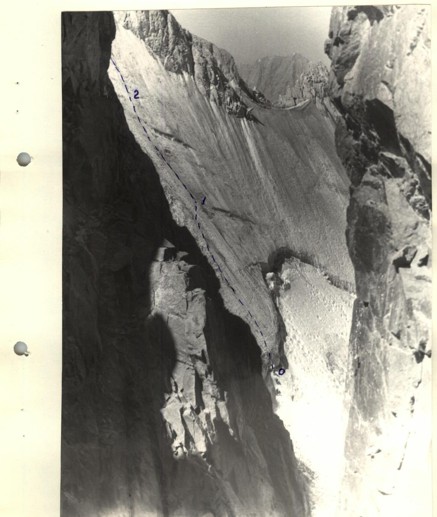
Photo 2. Ascent path to the saddle (sect. 0–1, 1–2).
Description of the approach to the route on peak 4804 via NW ridge, category 3B difficulty.
The group started the ascent from the base camp located under the "blockage" on the Arch-Kanysh river. The trail goes up along the left orographic bank of the Arch-Kanysh river to a meadow standing at the confluence of the Arch-Kanysh and Surmitash rivers. Then cross to the right bank of the Arch-Kanysh river and ascend the Surmitash valley in the direction of the Kosmonavtov horseshoe until the waterfall. Cross the Surmitash river near the waterfall. From here, peak 4804 is visible. From the "blockage" — 1.5–2 hours.
The ascent to the start of the route on peak 4804 begins on scree slopes with a characteristic light-yellow color, with the long and high ridge branching off from peak 4804 and obscuring almost the entire Kosmonavtov horseshoe remaining on the right. After 1 hour of ascent on scree, the glacier of peak 4804 comes into view.
The ascent continues:
- on scree and moraine of the glacier in the right orographic part of the peak 4804 cirque;
- the glacier should be crossed from left to right in the upper part, following the direction towards a deep bergschrund;
- through a large depression, reach the start of the route — a steep ice wall leading to the NW ridge of peak 4804.
From the "blockage" to the start of the route 5–6 hours.
Description of the route on peak 4804 via NW ridge, category 3B difficulty.
The ascent to the summit begins on a steep ice slope towards the saddle in the NW ridge, visible from the approach. To reach the ice, a fairly wide bergschrund must be overcome. In the narrowest part of the bergschrund, ice axes are used as artificial footholds. Further movement is up steep ice (55°), resembling "natеchniy" ice in structure (sect. 0–1). Movement is in crampons, with piton belay. Go to the right along the route in the direction of a noticeable ice fold. After 100–120 m, the steepness decreases somewhat to 50–45° (sect. 1–2, 2–3). On these sections, with a total length of 120 m, movement continues straight up along the ice fold on softer, porous ice. Belay is also via pitons. Sect. 2–3 leads to a saddle in the NW ridge.
From the saddle, 40 m along moderately difficult rocks (sect. 3–4) towards an inner corner. Movement is alternating, belay via rock outcrops.
Sect. 4–5 — a pronounced inner corner (40 m), which is overcome with piton belay. 2–3 m before the end of the corner, move to its right wall and, going to the right, reach a ledge. Movement along ledges is from right to left upwards (sect. 5–6). Rocks are heavily fragmented, belay is via pitons. The detour leads to the pre-summit ridge.
The ridge is heavily jagged. Along the route, two 3–5 m high "gendarme" rocks are overcome (head-on). The total length of the section after exiting the inner corner is 80 m.
From the saddle to the summit 2–3 hours.
The sharp pre-summit ridge leads to the summit of peak 4804, which is a sharp 3 m high "gendarme" rock with a narrow ledge at the base. On the summit — a cairn.
From the bergschrund to the summit 5–6 hours. Descent is by the ascent route.
TABLE OF MAIN ROUTE CHARACTERISTICS
| Date | Designation | Average steepness, ° | Length, m | Terrain type | Diff. cat. | Condition | Weather conditions | Rock pitons | Ice pitons |
|---|---|---|---|---|---|---|---|---|---|
| 0–1 | 55 | 120 | ice slope | 4 | "natechniy" ice | 18 | |||
| 1–2 | 50 | 80 | ice slope | 3–4 | porous ice | 7 | |||
| 2–3 | 45 | 40 | ice slope | 3 | porous ice | 2 | |||
| August 15, 1978 | 3–4 | 40 | 40 | ridge | 3 | fragmented rock | ○ | ||
| 4–5 | 60 | 40 | inner corner | 3 | fragmented rock | π | 4 | ||
| 5–6 | 40 | 80 | ridge | 3 | fragmented rock | ∝ | 7 | ||
| 0–6 | 50 | 400 | combined | 3 | rock-ice | 11 | 27 |