Ascent Passport
-
Ascent class: technical
-
Ascent area: Pamir-Alai, Alai ridge
-
Peak, its height: Leningradets, 5040 m, via North wall Ascent route: 5B (validated route)
-
Proposed difficulty category: 5B category of difficulty
-
Route characteristics: Height difference 1200 m
Average steepness 70°
Length of sections:
- 3–4 category of difficulty — 630 m
- 5 category of difficulty — 650 m
- 6 category of difficulty — 20 m
-
Pitons driven:
- For belay:
- rock — 39
- ice — 19
- protection elements — 13
- For creating RPS (Rope Protection System):
- rock — 2
- ice — 0
- protection elements — 1
- For belay:
-
Number of climbing hours: 14 hours
-
Number of bivouacs and their characteristics: no bivouacs
-
Surname, name, patronymic of participants, their sports qualification:
Tarasevich Sergey Nikitich, Candidate Master of Sports Okladnikov Viktor Efremovich, Candidate Master of Sports
-
Team coach: Yakovlev Vitaly Dmitrievich, senior instructor, Master of Sports of the USSR
-
Date of departure and return:
August 10, 1980, 2:00 AM — departure, August 10, 1980, 4:00 PM — return.
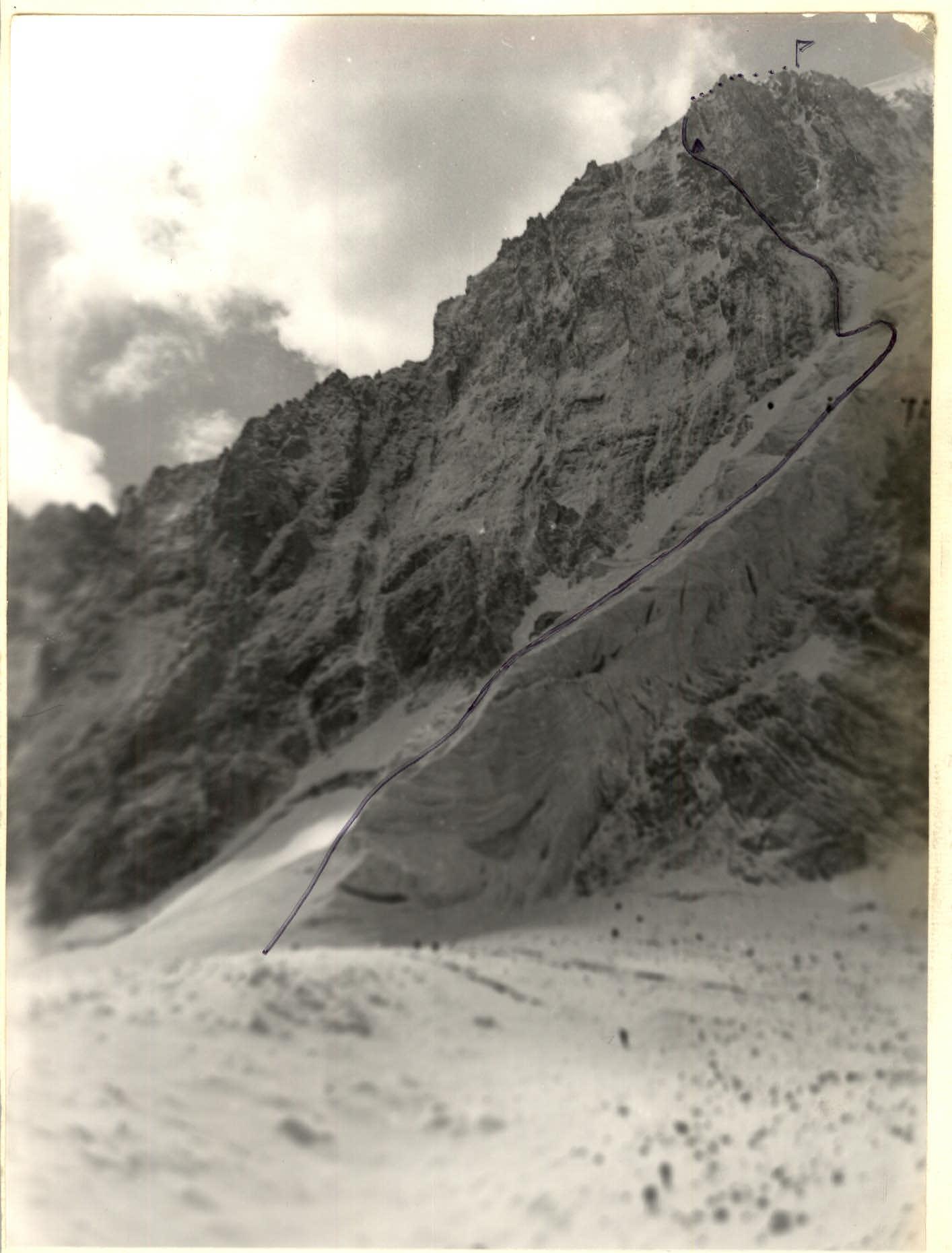
TABLE OF MAIN ROUTE CHARACTERISTICS

Explanations for the table
Section
- 0–1
- 1–2
- 2–3
- 3–4
- 4–5
- 5–6
- 6–7
- 7–8
- 8–9
- 9–10
- 10–11
- 11–12
- 12–13
- 13–14
- 14–15
Explanation
- Snow slope
- Bergschrund with snow bridges, with gullies from snow slides where ice is exposed.
- Ice slope with gullies.
- Rock outcrops with flowed ice.
- Destroyed ridge with slabs facing down. Sandy coating. Loose rocks.
- Crossing from the left part of the ridge to the right with overcoming an overhanging rusty fragment. Rocks hold well.
- Ridge turning into a wide crevice. Rocks falling! Caution!
- Shoulder of the ridge. Semi-reclined bivouac possible. Rocks are friable.
- Narrow ridge with a traverse to the wall of the left part of the ridge. Sand on the rocks. Flowed ice on the wall.
- Wall with very destroyed rocks. Rocks falling! Caution!
- Traverse along the wall to the right part of the ridge. Rocks are destroyed. Being swung out. The second has to make double handrails with rope pulling through.
- Right part of the ridge with an exit to its summit. Finely fragmented rock. No place to drive a piton.
- Crossing an ice gully to rock outcrops on the left. Control cairn.
- Rock outcrops. Destroyed rock! Caution!
- Snow ridge leading to the summit.