Ascent made on Peak "Krugozor" (conditionally) 4000 m
- Class: Technical
- Climbing area: Pamir-Alay
- Ascent route: p. 4000 m (Krugozor) via the northern ridge
- Ascent characteristics: Elevation gain 600 m. Length of difficult sections 200–200 m
- Pitons driven: rock 16 pcs.
- Number of climbing days: 1
- Number of climbing hours: 12
- Number of nights: —
- Team name: s/k "Polytechnic"
- Team composition:
- SHVEDCHIKOV I.P. — leader, Master of Sports
- GELLER A.B. — participant, 1st sports category
- EGOROV V.M. — participant, 1st sports category
- NOVIKOV E.D. — participant, 1st sports category
- FEDOSOV A.V. — participant, 1st sports category
- Ascent time: 17–18 August 1976
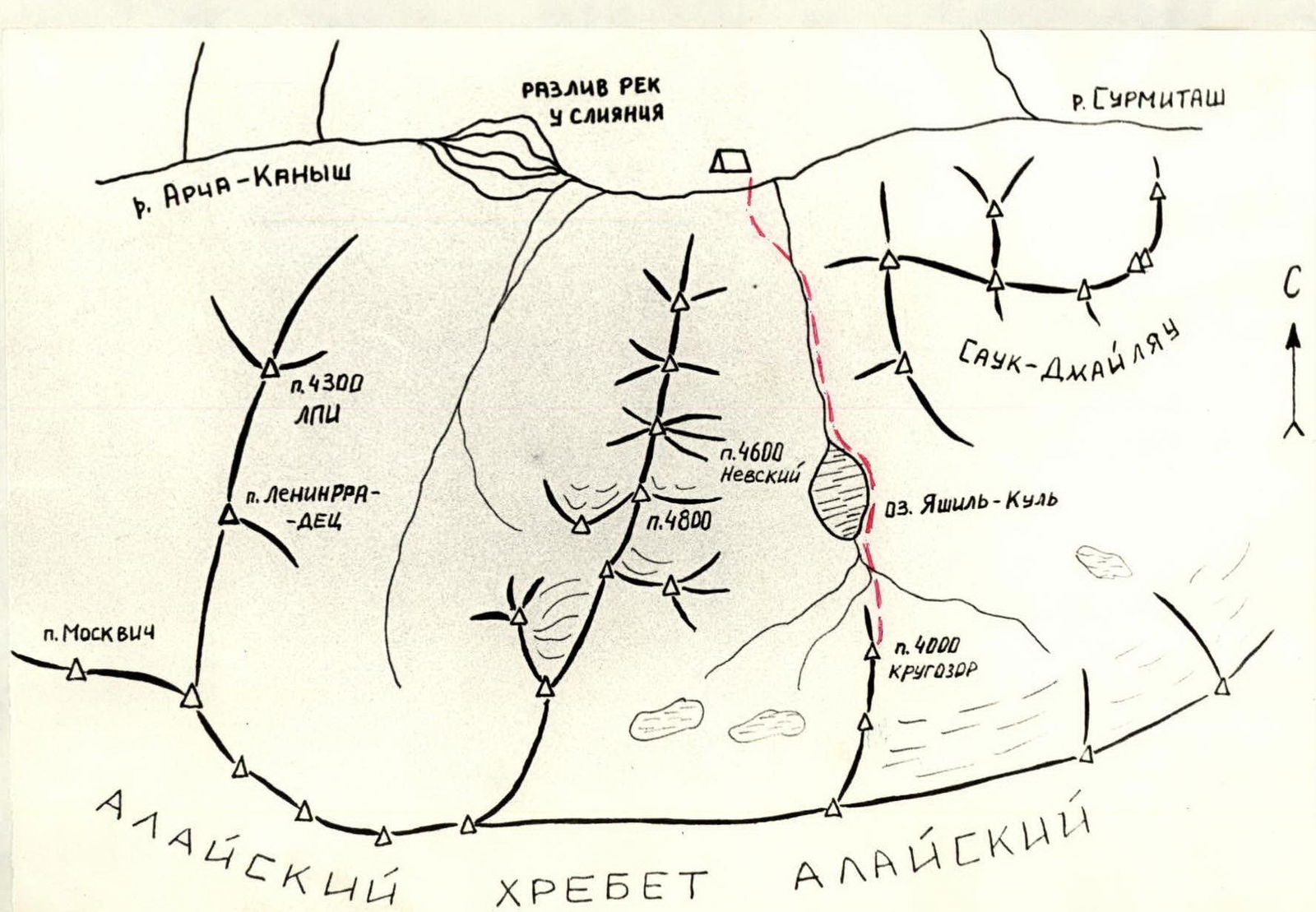
Peak 4000 m (approximately "Krugozor") is located in the northern spur of the Alay Range, which divides the valley of Lake Yashil-Kul.
From the confluence of the Surmitash River and the river flowing from the Yashil-Kul tract, upstream to Lake Yashil-Kul. Then along the right orographic tributary to the base of the route.
The approach from the confluence of the rivers takes 2.5–3 hours. From the river, via the middle talus to the base of the rock-talus couloir.
The couloir is climbed on the left (section R1). Rockfall hazard!
At the top of the couloir, there is a wall with smooth slabs 100 m (section R2).
On the saddle between the first and second gendarmes, there is a control cairn.
Further, the route follows the ridge:
- The second and third gendarmes (section R3) are passed upwards to the left via poorly defined internal corners. Rocks of moderate difficulty.
- The fourth gendarme — one rope length upwards, protection — outcrops, pitons.
- Then along the heavily serrated ridge to the grey rocks. The rocks on the ridge are bypassed on the right.
- Along the characteristic grey rocks with white spots on the right to the ridge.
- Along the ridge to the 7th gendarme.
The slab of the 7th gendarme is about 60 m (section R4). Rocks are more difficult than average and very rockfall-prone. Extremely careful work with the rope. Pitons for protection. The slab is climbed on the right side of a poorly defined internal corner.
Again, exit onto the ridge. Movement along the ridge is simultaneous.
From the 9th gendarme, descend to the right in a spiral to the base of the summit tower (section R5).
The summit tower is climbed via the left edge of the external corner — 1.5 ropes on grey monolithic rocks. Pitons for protection (section R5–R6).
Descent from the summit along the ridge to the south. After reaching the shoulder (section R7), descend on a rope (ice piton driven) to a wide talus shelf (section R8).
Further descent along the ridge to the base of the gendarme. The gendarme is bypassed on the left to the shoulder above the talus saddle. Descent on a rope about 20 m. Control cairn (section R9).
Then descent is possible:
- to the right via wide talus couloirs;
- to the left via wide talus couloirs.
Table
Route passage by sections
| Section # | Length | Character of section | Steepness | Note |
|---|---|---|---|---|
| R1 | 180–200 | rock-talus couloir | 30°–50° | rockfall hazard! |
| R2 | 100 | wall | 60° | piton protection |
| R3 | 250–300 | ridge with gendarmes | 50°–70° | piton protection, rockfall hazard |
| R4 | 60 | slab | —"— | —"— |
| R5 | 200 | ridge | simultaneous movement | |
| R5–R6 | 40 | summit tower | 60°–70° | piton protection |
| R6–R7 | 80 | ridge | 30° | |
| R7–R8 | 40 | walls on ridge | 70° | rappel |
| R8–R9 | 200 | ridge with wall | rappel 20 m | |
| R9 | talus couloir |
