XXXII USSR Climbing Championship – Rock Climbing Category – Pamir-Alai –
Report
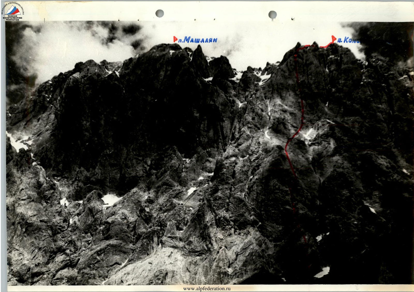
The team from the Sports Committee of the Ministry of Defense of the USSR on the ascent of Peak Konstruktors (4100 m) via the center of the left part of the South Face.
-
Mikhailov A.A. — team leader and coach — Master of Sports
-
Kharitonov A.P. — deputy leader — Candidate for Master of Sports
-
Zadvoryev Yu.V. — team member — Candidate for Master of Sports
-
Povolotsky V.Yu. — team member — Candidate for Master of Sports (–9) 07.81
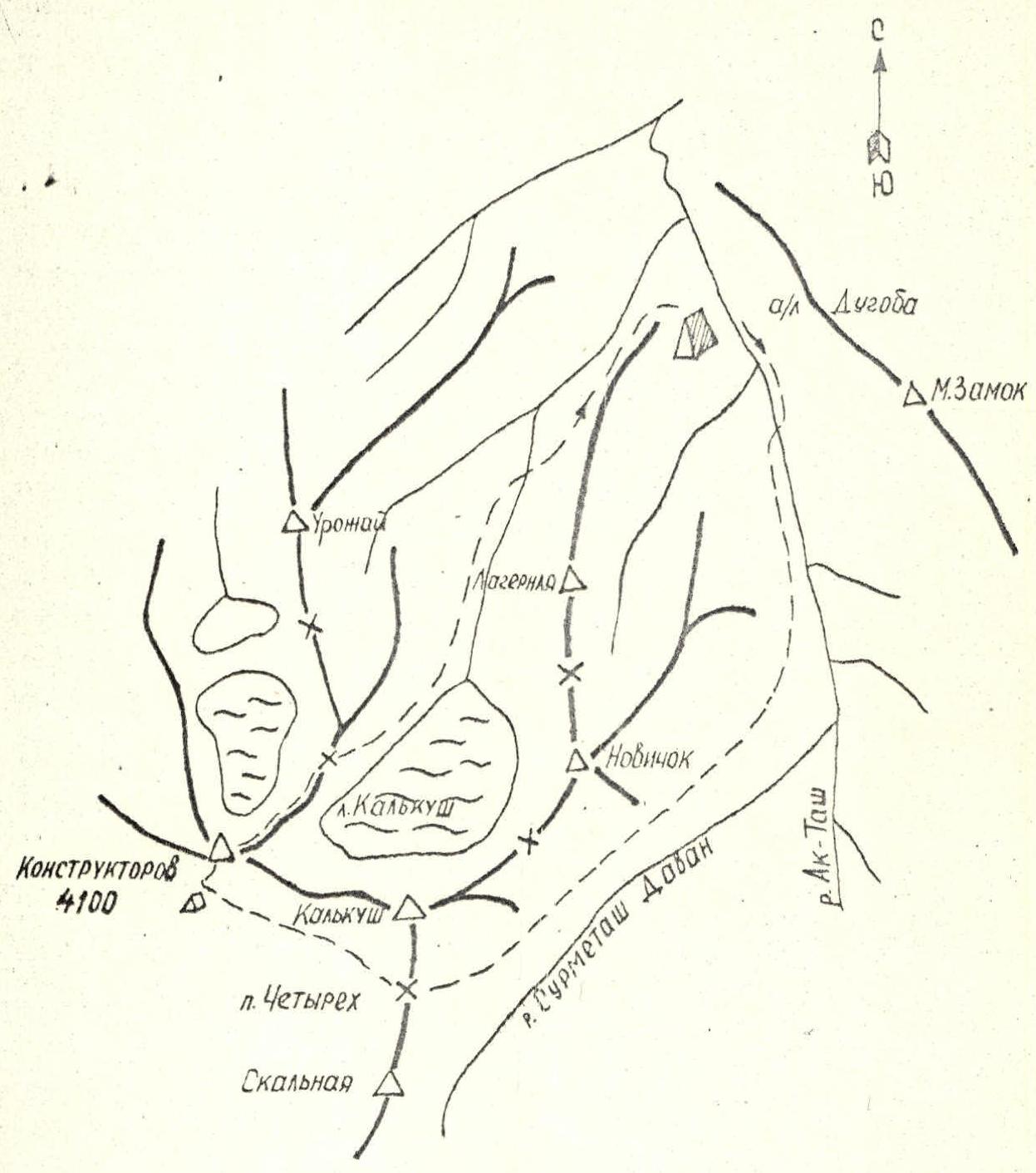
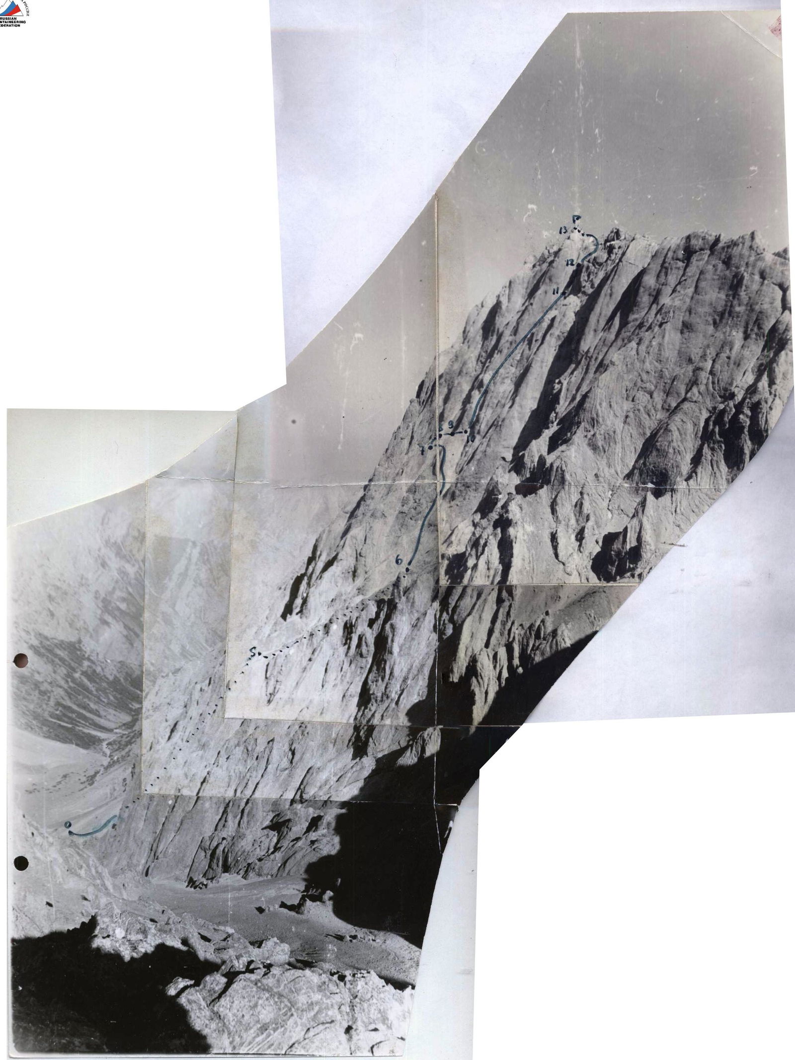
Map of the ascent area to Peak Konstruktors via the center of the left part of the South Face

- Description of the Approach to the Route
Peak Konstruktors is located in one of the spurs of the Alai ridge, east of Peak Kalkush. The massifs of peaks Konstruktors, Kalkush, and Novichok form a ridge that borders the cirque of the Kalkush glacier to the south.
The path from the "Dugoba" alpine camp to the overnight stay under the South Face of Peak Konstruktors includes:
- moving up the gorge;
- passing to the confluence of the Ak-Tash and Surmetash-Davan rivers;
- crossing the "Four" pass.
The total approach time is about six hours.
The path from the overnight stay lies up the scree and rock outcrops in the direction of the snowfield, to the left of which is the start of the route, and takes 40 minutes.
The total approach time from the "Dugoba" alpine camp to the route is 6.5 hours.
- Information about Reconnaissance and Supply Trips
The team from the Armed Forces arrived in the area of the objects entered for the USSR Championship on June 16, 1981, setting up a base camp near the Dugoba alpine camp.
The first reconnaissance trip was carried out on June 21, 1981.
The trip was made to:
- familiarize themselves with the massifs of peaks Mashalyan and Konstruktors;
- study the approach paths;
- choose a route for discussion by the coaching council;
- familiarize themselves with the state of the declared routes and their features.
During this trip, a tent, some supplies, and fuel were taken to the "Four" pass.
The reconnaissance trip was conducted by a group consisting of:
- Mikhailov A.A. — Master of Sports
- Yevsyukov G.K. — Master of Sports
- Povolotsky V.Yu. — Candidate for Master of Sports
- Kharitonov A.P. — Candidate for Master of Sports
- Zadvoryev Yu.V. — Candidate for Master of Sports
- Chiyanoy N.E. — Candidate for Master of Sports
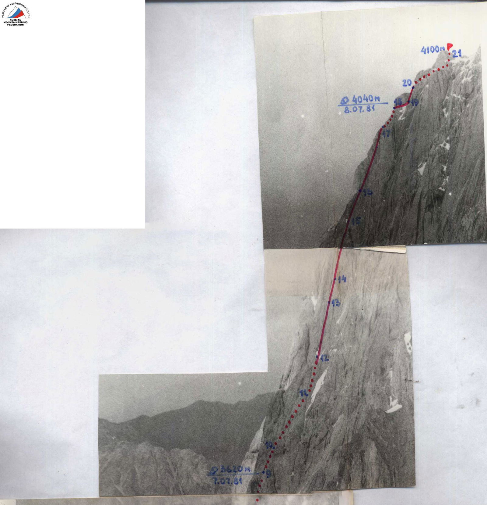
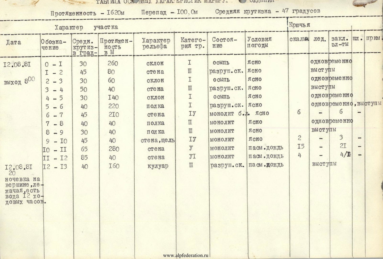
Table of main characteristics of the ascent route to Peak Konstruktors via the center of the left part of the South Face
| Date | Designation | Average steepness, degrees | Length, m | Terrain character | Complexity category | Condition | Weather conditions | Rock pitons | Bolt pitons | Placement elements |
|---|---|---|---|---|---|---|---|---|---|---|
| 07.07.81 | R0–R1 | 76 | 40 | Wall | 5 | Monolith | clear | 7 | – | 3 |
| R1–R2 | 80 | 40 | Inner corner | 5 | –"- | –"- | 4 | – | 5 | |
| R2–R3 | 75 | 40 | Wall | 5 | –"- | –"- | 5 | – | 3 | |
| R3–R4 | 65 | 40 | Slab | 5 | –"- | –"- | 3 | – | 2 | |
| R4–R5 | 78 | 40 | Inner corner | 5 | –"- | –"- | 3 | – | 6 | |
| R5–R6 | 80 | 40 | Wall | 5 | –"- | –"- | 5 | – | 5 | |
| R6–R7 | 80 | 40 | Wall | 5 | –"- | –"- | 6 | – | 5 | |
| R7–R8 | 78 | 40 | Chimney with inner corner at the top | 5 | –"- | –"- | 4 | – | 3 | |
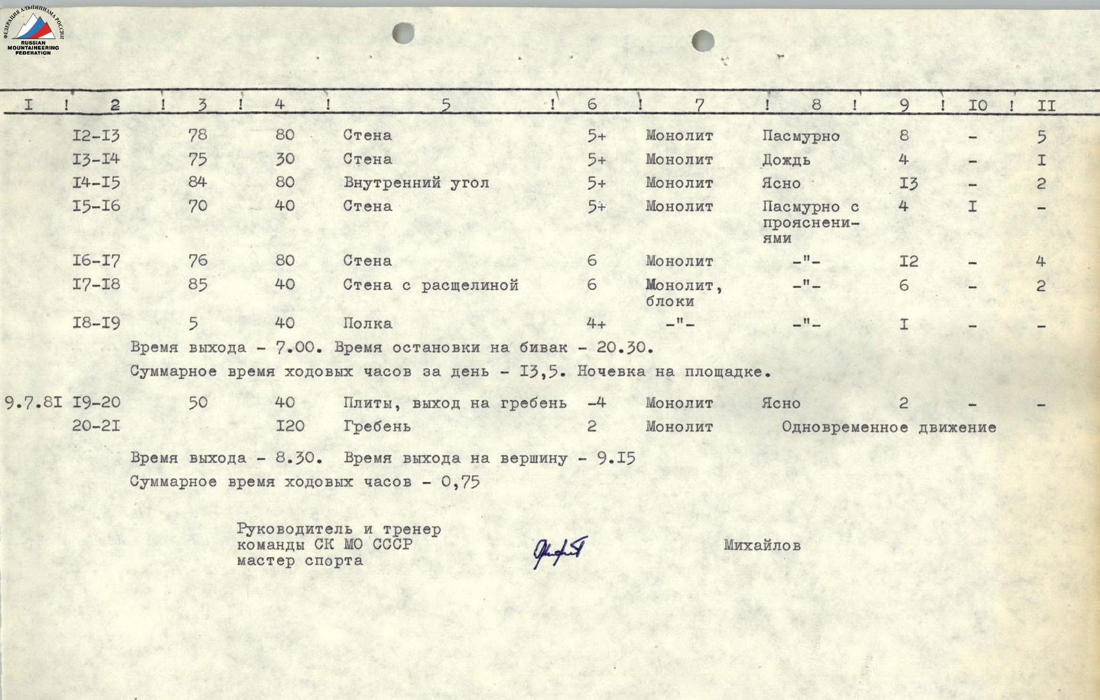
| R8–R9 | 75 | 120 | Wall | 6 | Monolith with blind cracks | Rain with snow | 12 | – | 9 |
Departure time — 8:00. Time of stopping for bivouac — 19:30. Total walking hours for the day — 11. Uncomfortable overnight stay on a rock shelf.
| Date | Designation | Average steepness, degrees | Length, m | Terrain character | Complexity category | Condition | Weather conditions | Rock pitons | Bolt pitons | Placement elements |
|---|---|---|---|---|---|---|---|---|---|---|
| 08.07.81 | R9–R10 | 75 | 50 | Crevice | 5 | Monolithic with smoothed-out holds | Overcast | 5 | – | 2 |
| R10–R11 | 65 | 80 | Wall with ledges | 5 | Monolith type "ram's foreheads" | Wet snow | 8 | – | 1 | |
| R11–R12 | 80 | 40 | Inner corner | 5 | Monolith | Overcast | 6 | – | 5 | |
| R12–R13 | 78 | 80 | Wall | 5 | Monolith | Overcast | 8 | – | 5 | |
| R13–R14 | 75 | 30 | Wall | 5 | Monolith | Rain | 4 | – | 1 | |
| R14–R15 | 84 | 80 | Inner corner | 5 | Monolith | Clear | 13 | – | 2 | |
| R15–R16 | 70 | 40 | Wall | 5 | Monolith | Partly cloudy with clearings | 4 | 1 | – | |
| R16–R17 | 76 | 80 | Wall | 6 | Monolith | –"- | 12 | – | 4 | |
| R17–R18 | 85 | 40 | Wall with crevice | 6 | Monolith, blocks | –"- | 6 | – | 2 | |
| R18–R19 | 5 | 40 | Ledge | 4 | –"- | –"- | 1 | – | – |
Departure time — 7:00. Time of stopping for bivouac — 20:30. Total walking hours for the day — 13.5 hours. Overnight stay on a platform.
| Date | Designation | Average steepness, degrees | Length, m | Terrain character | Complexity category | Condition | Weather conditions | Rock pitons | Bolt pitons | Placement elements |
|---|---|---|---|---|---|---|---|---|---|---|
| 09.07.81 | R19–R20 | 50 | 40 | Slabs, exit to ridge | 4 | Monolith | Clear | 2 | – | – |
| R20–R21 | 120 | Ridge | 2 | Monolith | Simultaneous movement |
Departure time — 8:30. Time of reaching the summit — 9:15. Total walking hours — 0.75 hours.
Team leader and coach of the USSR Ministry of Defense Sports Committee, Master of Sports Mikhailov
Description of the Route Passage
(Explanation for the table of main characteristics of the ascent route to Peak Konstruktors via the center of the left part of the South Face)
July 7, 1981
At 8:00, the team began the ascent. The first rope team, Mikhailov–Povolotsky, worked together. Mikhailov led. The route primarily follows a monolithic wall. At the end of the R3–R4 section, on a small platform, there was the first control point. Then, a 40-meter inner corner led to a smooth wall (80 m) with few holds. The next section (R7–R8) started with a chimney transitioning into an inclined inner corner. The weather deteriorated, and it started raining. The last three ropes of the planned section for the day, consisting of steep monolithic rocks, were led by Kharitonov. The climbing was extremely challenging. The "holds" were small depressions and roughness. Blind cracks made it difficult to hammer in pitons. At 16:30, the wall was hit by a heavy snow and rain charge, forcing a 25-minute stop. Under continuous rain, at 19:30, we reached the planned bivouac site under a diagonal crevice in the middle of the route. On a narrow shelf under an overhanging rock awning, we began organizing the bivouac.
Covered:
- 440 m of the route;
- 49 pitons hammered in;
- 41 placements used.
The altitude difference from the start of the route according to the altimeter was 400 m.
July 8, 1981
At 7:00, we started moving. Povolotsky led the 50-meter diagonal crevice. The second rope team worked independently. On sections R12, R13, R14, Povolotsky led. Subsequent sections were led by Kharitonov. 240 meters of sheer monolithic rocks with a lenticular character, leading to the pre-summit ridge, were the most challenging part of the route on the South Face of Peak Konstruktors. At 20:30, the wall was passed. We began organizing a bivouac on a platform just below the pre-summit ridge. On this day, we covered 520 m of the route, the altitude difference according to the altimeter was 420 m, 68 pitons were hammered in, and 22 placements were used.
July 9, 1981
At 8:30, we left the bivouac and ascended to the summit via a straightforward ridge.
On the same day, the team returned to the base camp near the Dugoba alpine camp.
Team leader and coach of the USSR Ministry of Defense Sports Committee, Master of Sports Mikhailov
General Route Characteristics:
- Length — 1620 m
- Altitude difference — 1000 m
- Average steepness — 47 degrees
Table of main characteristics of the ascent route
| Date | Designation | Average steepness, degrees | Length, m | Terrain character | Complexity category | Condition | Weather conditions | Rock pitons | Ice pitons | Placement elements | Bolt pitons | Notes |
|---|---|---|---|---|---|---|---|---|---|---|---|---|
| 12.08.81 | R0–R1 | 30 | 260 | slope | 1 | scree | clear | simultaneous | ||||
| R1–R2 | 45 | 80 | wall | 3 | broken rock | clear | ledges | |||||
| departure 8:00 | R2–R3 | 30 | 60 | slope | 1 | scree | clear | simultaneous | ||||
| R3–R4 | 50 | 40 | wall | 3 | broken rock | clear | ledges | |||||
| R4–R5 | 30 | 140 | slope | 1 | scree | clear | simultaneous | |||||
| R5–R6 | 40 | 220 | ledge | 1 | broken rock | clear | simultaneous, ledges | |||||
| R6–R7 | 45 | 210 | wall | 4 | monolith, b.l. | clear | 6 | 6 | ||||
| R7–R8 | 40 | 40 | ledge | 2 | monolith | clear | simultaneous | |||||
| R8–R9 | 30 | 40 | ledge | 2 | monolith | clear | ledges | |||||
| R9–R10 | 45 | 40 | wall, crevice | 4 | monolith | clear | 2 | 3 | ||||
| R10–R11 | 65 | 280 | wall | 5 | monolith | overcast, rain | 15 | 21 | ||||
| R11–R12 | 85 | 40 | wall | 6 | monolith | overcast, rain | 4 | 4/B | ||||
| 12.08.81 | R12–R13 | 40 | 160 | couloir | 3 | broken rock | overcast, rain | ledges |
Overnight stay on the summit, lying down, water available. 12 walking hours.
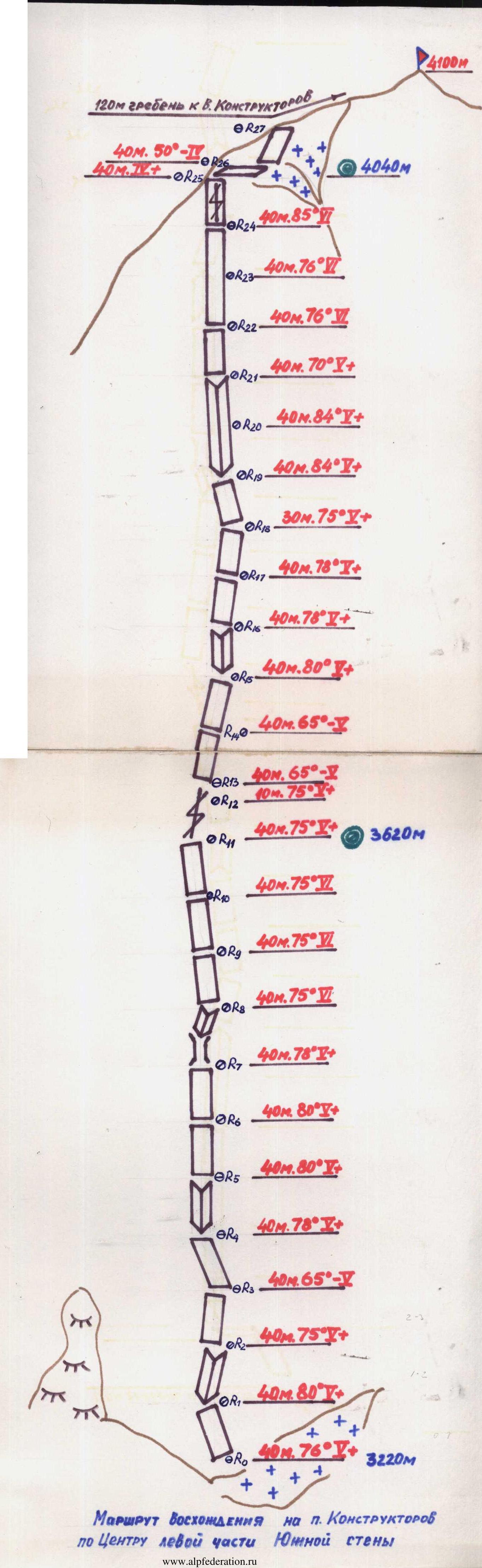
Route of ascent to Peak Konstruktors via the center of the left part of the South Face
Brief Explanation of the Table
- R0–R1: Scree slope, not dangerous.
- R1–R2: Broken rocks, loose stones.
- R2–R3: Scree and broken rocks in sections.
- R3–R4: Broken rocks, loose stones.
- R4–R5: Scree and broken rocks in sections.
- R5–R6: Broken ledges, not dangerous.
- R6–R7: Smoothed walls, monolithic. Movement on friction. Exit to the bastion summit.
- R7–R8: Ledge. Loose stones! Possible overnight stay, lying down, no water.
- R8–R9: Ledge. Monolith. Movement towards a chimney in the shape of a "comma" to a cave.
- R9–R10: Movement up a crevice straight up. Exit from the cave is difficult.
- R10–R11: Traverse one rope to the right into a chimney. Smoothed slabs. Difficult climbing. For the last part, a "fishing rod" is necessary. Then, up the chimney. In wet weather, it presents significant difficulties.
- R11–R12: Exit from the chimney up a wall into a couloir leading to the summit. Rockfall hazard. Climbing is difficult.
- R12–R13: Couloir with broken rocks. Exit to the summit. Descent via the North Ridge by route 3B category of complexity. Two rappel ropes. Then down the scree slope into the cirque of Peak Kalkush.