Climbing Passport
- Climbing category: technical (combined)
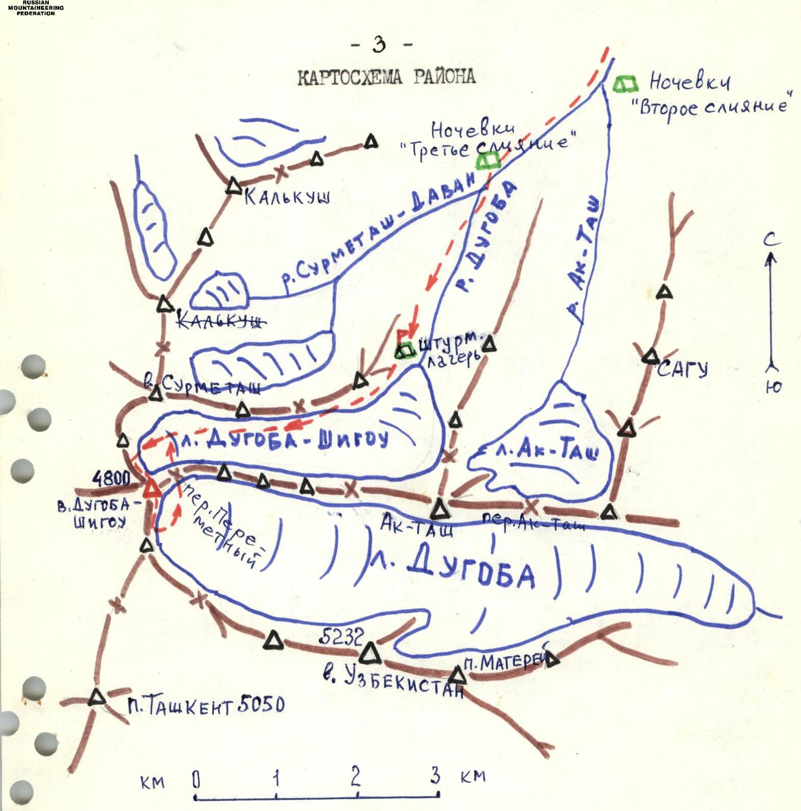
- Climbing area: Pamir-Alay, Kollektor Range, DUGOBA-SHIGOU river valley.
- Peak: DUGOBA-SHIGOU (4800 m), via the ice slab on the Western ridge, combined route.
- Category 4A difficulty.
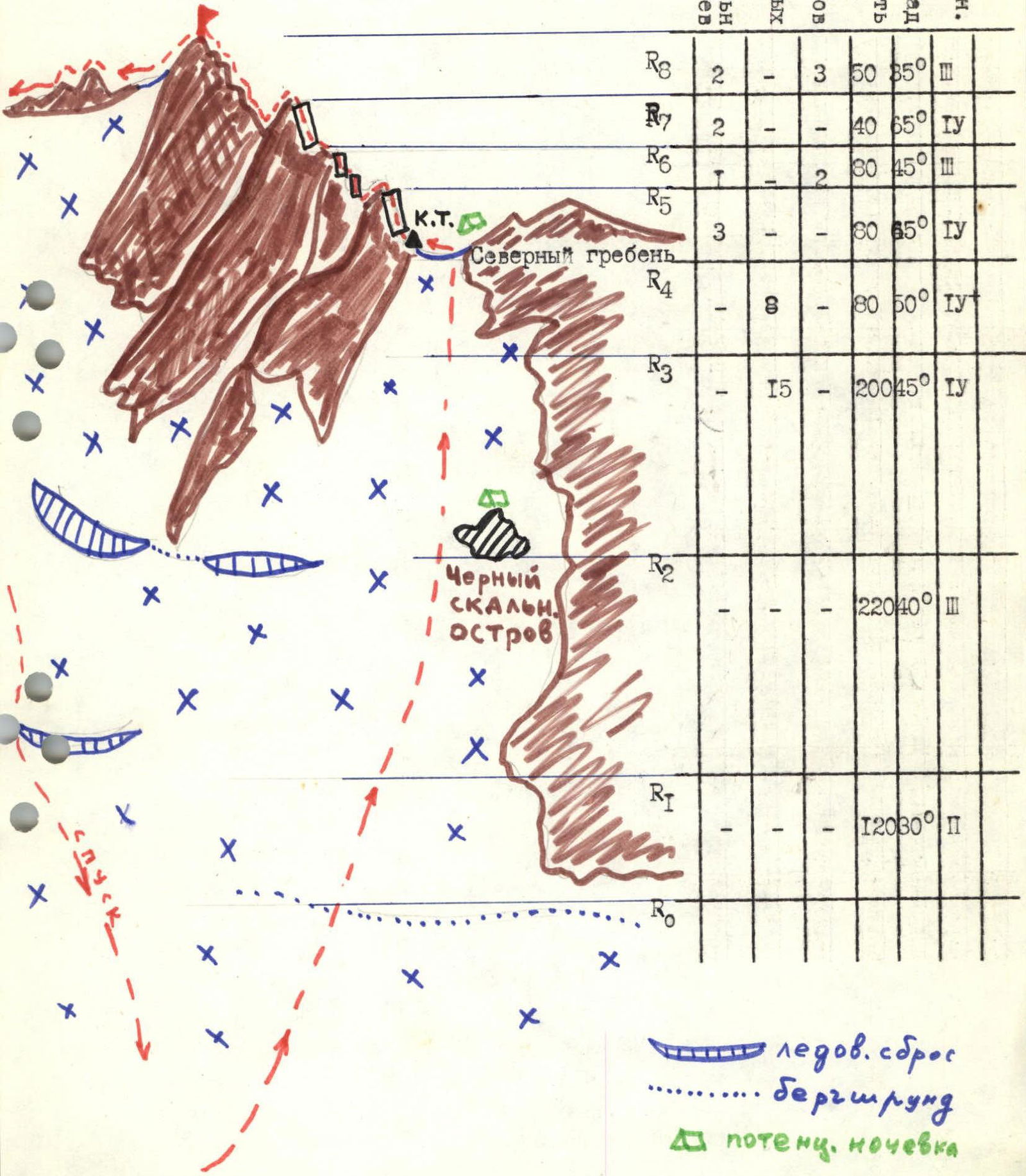
- Route characteristics: elevation gain 650 m, length of Category IV sections 250 m, average steepness of the snow-ice part 45°.
- Pitons used on the route: rock 8 ice 23 chocks 5
- Total climbing hours: 8 hours
- Surname, name, patronymic of the leader and participants, their qualification:
KULIKOV I.V. — CMS, LUKASHIN V.I. — CMS, a 2-person team.
Observers:
- SITCHIKHIN D.V. — CMS
- ZAMYATINA R.E. — CMS
- Number of bivouacs on the route: none.
- Team coach: VOCHAROV Vladimir Nikolaevich, Master of Sports of the USSR.
- Date of departure: August 4, 1988. Date of return: August 4, 1988.
- Organization: AUSP "Dugoba".
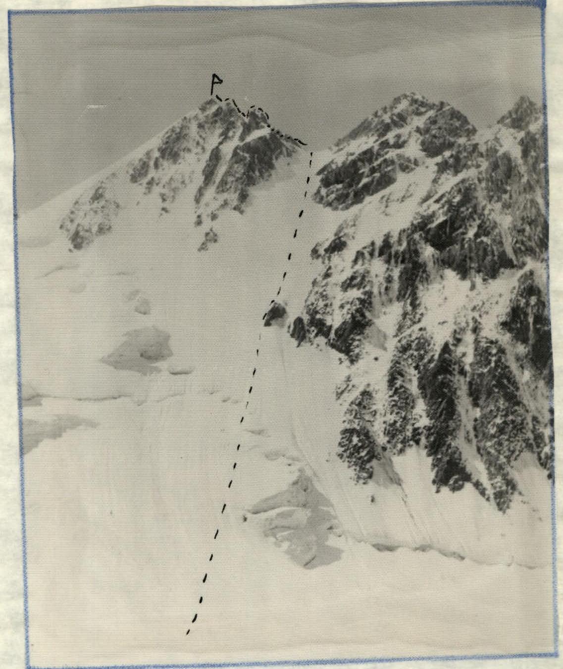
General view of the peak Dugoba-Shigou (4800 m) and the first ascent route, category 4A, combined. Route diagram in symbols for peak Dugoba-Shigou, 4800 m, category 4A.
Approach to the Route Description
From the bivouac by the lakes of the terminal moraine of the Dugoba-Shigou glacier, follow the gully between the slope of peak Sypuchaya and the lateral moraine of the Dugoba-Shigou glacier, then cross the moraine and continue along the glacier towards the snow-ice slopes of peak Dugoba-Shigou — 1.5 hours. (The approach to the bivouac from the 3rd confluence takes 3 hours along the trail following the Dugoba-Shigou river on the right — see map).
Brief Explanation of the Route Diagram
- Section R0–R1: snow slope, belay via ice axe. In good weather, ice is possible in the upper part. Cross the bergschrund.
- Section R1–R2: snow-ice slope with a steepness of 40°, ice covered with a firn layer, sometimes dense snow, belay via ice axe. Move towards the black rock island. There's a platform at the top of the island.
- Section R2–R3: ice slab. Ice sometimes covered with a thin firn layer. Belay via ice screws, alternating movement. Move along the center of the ice slab, avoid the rocks as they are fragile, and there's a risk of rockfall, especially on the left.
- Section R3–R4: ice wall with a steepness of 50–55°, exposed, hard ice, challenging climbing on the front points of crampons with an ice hammer. Belay via ice screws, alternating movement or via fixed ropes. Exit onto a saddle. This is a convenient spot for a bivouac. Control point.
- Section R4–R5: fragile rock wall covered with snow. Piton belay. The pinnacles on the ridge are bypassed on the right.
- Section R5–R6: small rock walls on a sharp ridge, rocks are fragile, belay via rock features, chocks. One channel piton is used.
- Section R6–R7: ascent onto a pinnacle, piton belay, climbing category IV difficulty. Descent from the pinnacle into a 12 m deep gap. The gap's saddle is very sharp.
- Section R7–R8: sharp, местами разрушенный гребень, leading to the summit. Piton belay, chocks are used.
Descent
Descent is advisable via the eastern ridge. On the other side of the summit, towards peak Uzbekistan, the ridge is fragile and sharp for about 200 m. Then descend from the ridge to the north onto a steep snow-ice slope leading to Peremetny pass, from which the Dugoba-Shigou glacier is on the left and the Dugoba glacier is on the right. Descent is possible in both directions. However, if you need to return to the bivouac in the Dugoba-Shigou valley, you should descend to the pass (170 m of ice with alternating belay via ice screws) and then down to the Dugoba-Shigou glacier.
The descent goes along a snow-ice slope with a steepness of 40–45°, 300 m. Be cautious: crevasses and bergschrund at the end of the slope! Alternating movement, belay via ice screws, sometimes via ice axe. Descent is face-in to the slope. Then follow the glacier and moraine to the bivouac site.
Descent onto the Dugoba glacier is easier, but you will need to return through a different valley — via Ak-Tash pass into the Ak-Tash valley. This descent is advisable in bad or deteriorating weather, or when fog sets in.
The descent route from peak Dugoba-Shigou via Peremetny pass into the Dugoba-Shigou glacier cirque is a potential category 2B–3A route, combined. It was traversed by the training group SS-2 on August 4, 1988 (team from Ternopol, led by instructor B.T. Reshetukha), but the Ternopol team (led by instructor B.T. Reshetukha) never submitted a report on this ascent.
Route Guidance
a. It's advisable to start the route early, but no later than 8:00 AM. b. Assess the avalanche danger on the route at the beginning of summer and after bad weather (this also applies to the descent route).
Compiled by: leader Kulikov I.V., observer Sitchikhin D.V., August 7, 1988.


