Ascent Passport
- Ascent category — rock climbing
- Ascent area — Archа-Kanysh gorge (Pamir-Alay)
- Ascent route — Peak XXII Olympiad (4550 m) via the center of the Eastern wall
- Ascent characteristics: total altitude difference — 900 m, wall section difference — 450 m, average wall steepness — 85°, wall length — 510 m
- Pitons driven: rock — 130 pcs. (including for TAE — 11 pcs.), bolt — 15 pcs. (including for TAE — 9 pcs.), chocks — 107 pcs. (including for TAE — 15 pcs.)
- Time to reach the summit — 36.5 hours
- Time on the wall — 27 hours
- Number of overnight stays — two: 1 — hanging, two in a hammock, two on platforms; 2 — lying down
- Team name — team of instructors from "Shkhelda" alpine camp
- Team leader — Georgy Sergeyevich Shchedrin — Master of Sports of the USSR
Team members —
- Boris Alexandrovich Barulin — Master of Sports of the USSR
- Alexander Edgarovich Glushkovsky — Master of Sports of the USSR
- Anatoly Ivanovich Moshnikov — Candidate Master of Sports
- Team coach — G.N. Shchepalova, Master of Sports of the USSR
- Departure to the route — July 9, 1980. Return — July 11, 1980.
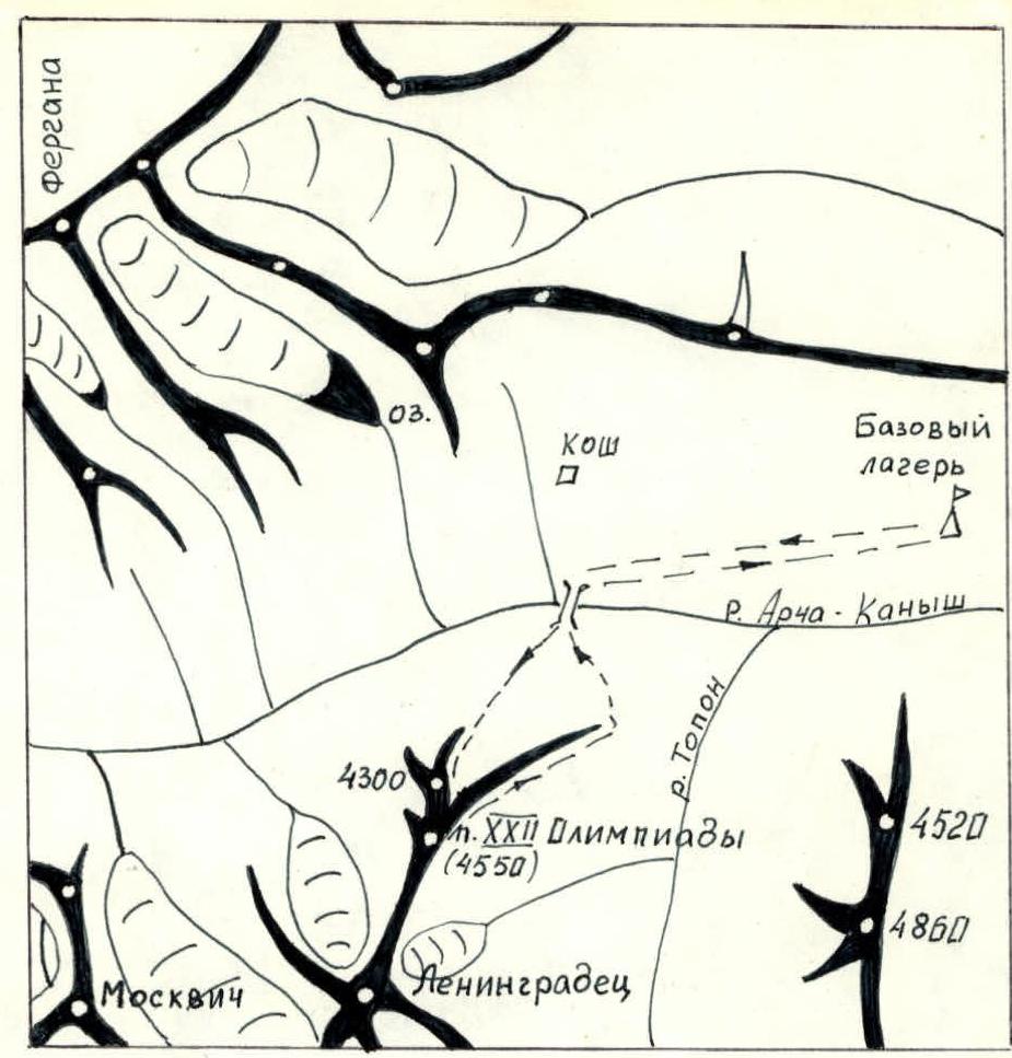
Brief description of the approach to the route. From the end of the road, where the branch of "Dugoba" alpine camp is located, it is necessary to go up along the left (orographic) bank of the Archа-Kanysh river. The trail is good. Two crossings are better made in the morning or evening hours.
After 7–9 hours of walking — a "large jam". The base camp was located on the "jam".
From the base camp:
- Along the left bank, 0.5 hours to the bridge (before the kosha).
- Crossing the bridge.
- Then along the right bank — under the Eastern wall.
The path from the base camp to the start of the route takes 2–2.5 hours.
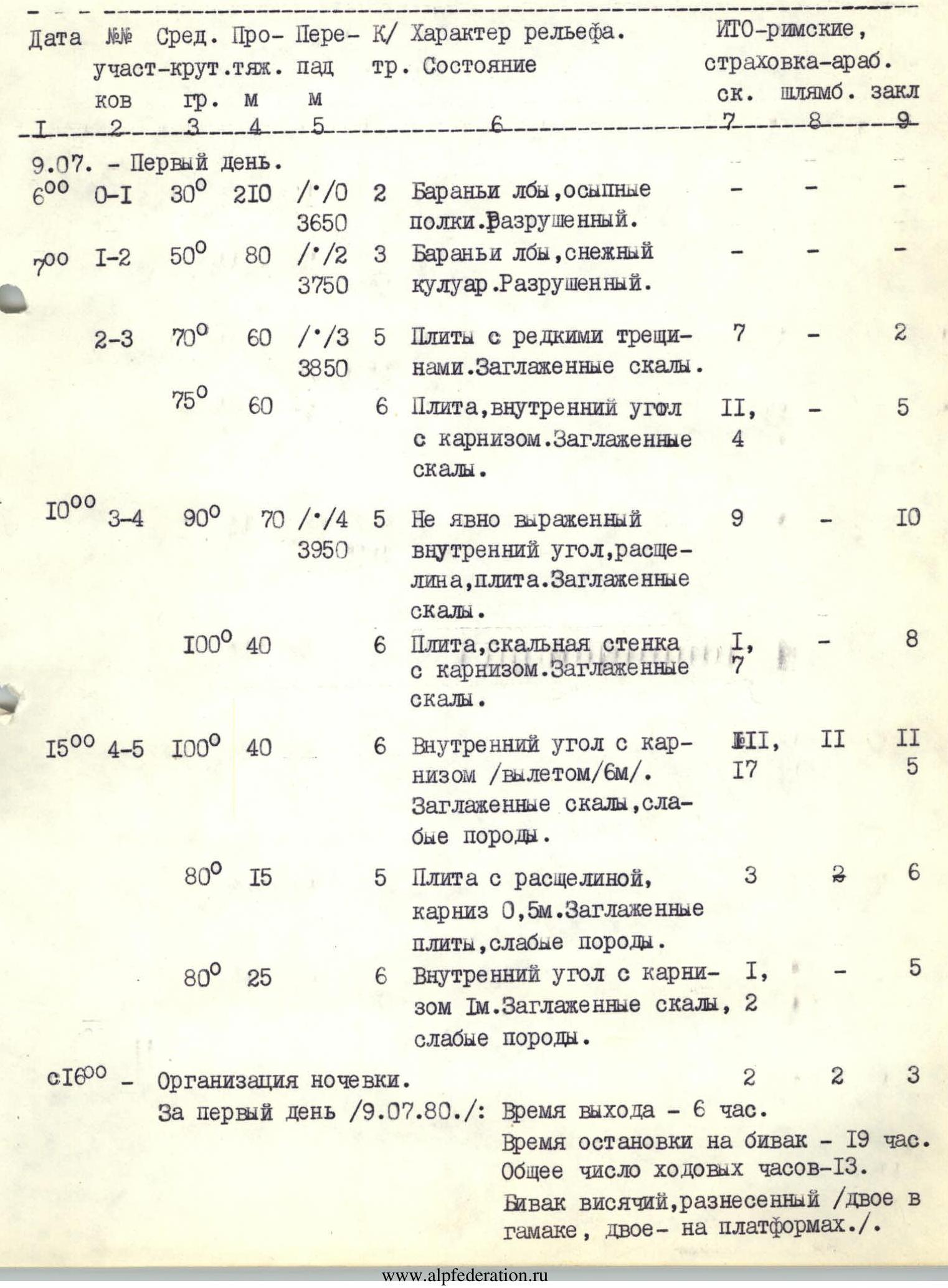
Table of main route characteristics
July 10, 1980 — Second day. 6:00 — First rope team ascent via ropes prepared in the evening. 8:00
- R4–R5, 90°, 40 m. /diff. cat. 5/. Diff. cat. 6. Wall with a slit, cornice, wall with an internal angle. Smoothed rocks, weak, crumbling rocks. (TAE: rock 1, bolt 1, chock III, 2). Height 4100 m.
- 80°, 20 m. Diff. cat. 6. Slab, shelf for three. No cracks. (TAE: rock 9, bolt VII, chock 1).
- R5–R6, 90°, 65 m. Diff. cat. 6. Smoothed slabs, internal corners, cornice. Blind cracks everywhere. (TAE: rock IV, bolt 1, chock VI, 13).
- 75°, 15 m. Diff. cat. 5. Internal corner, large shelf for the whole group. Blind cracks. (TAE: rock 2, bolt -, chock 3).
- 90°, 60 m. /diff. cat. 6/. Diff. cat. 6. Internal corner, two cornices 1 m and 0.5 m. Smoothed rocks, blind cracks. (TAE: rock 20, bolt -, chock IV, 11). Height 4200 m.
On the second day (July 10, 1980):
- Departure time — 6:00.
- Time of stopping for bivouac — 20:00.
- Total number of hours on the move — 14.
- Joint bivouac, lying down.
July 11, 1980 — Third day.
- 6:00 — First rope team ascent via ropes prepared in the evening.
- 7:00, R6–R7, 120 m. Diff. cat. 5. Ridge. Smooth walls, lack of cracks, unstable rock. Rain, snow, wind. (TAE: rock 7, bolt 1, chock 6).
- 70°, 10 m. Diff. cat. 4. Wall. Unstable rock. (TAE: rock 3, bolt -, chock 1).
- 35°, 30 m. Diff. cat. 4. Snowy couloir. Well-compacted snow.
- 10:00, R7–R8, 300 m. Diff. cat. 3. Dome, walls, snowfields. Summit of p. 4300 m.
- 12:30, 500 m. Diff. cat. 3. Ridge leading to Peak NII. Crumbly rocks.
- 15:30 — Summit of Peak XXII Olympiad (4550 m).
- 16:00 — Descent. Snow, crumbly rocks, scree.
- 19:00 — Return to base camp.
On the third day (July 11, 1980):
- Departure time — 6:00.
- Time of reaching the summit — 15:30.
- Total number of hours on the move — 9.5 hours.
TOTAL: Total number of hours to the summit — 35.5 hours (including on the wall section — 27 hours)
Wall height difference — 450 m.
Length of the wall section — 510 m.
Average steepness of the wall — 85°.
Length of sections of 5th diff. cat. — 280 m (including on the wall — 160 m).
Length of sections of 6th diff. cat. — 350 m.
Total number of pitons driven:
- rock — 130 pcs. (including for TAE — 11 pcs.)
- bolt — 15 pcs. (including for TAE — 9 pcs.)
- chocks — 107 pcs. (including for TAE — 15 pcs.)
Number of overnight stays — 2 (including one — hanging, the second — lying down)
Brief explanations for the table of main route characteristics
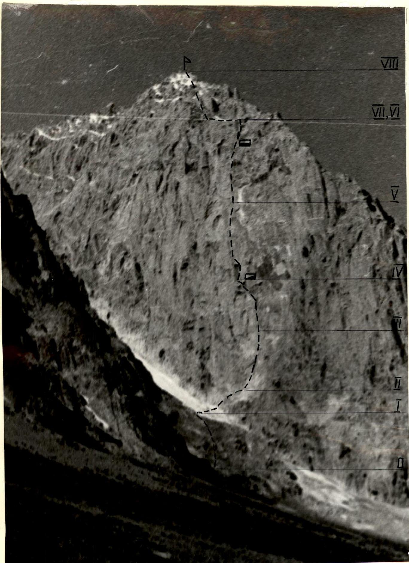
Section R0–R1. Rock "claw" is overcome with simultaneous belay. Early in the morning, icy sections are possible.
Section R1–R2. Snowy couloir is prone to rockfall. Pass before 7:00, one by one, observing the couloir. Then move up to the central upper point of the kara along rocks resembling "sheep's foreheads". The section is overcome with simultaneous belay.
Section R2–R3. Direction of movement is straight up, first along steep rocks resembling "sheep's foreheads", and then along a large internal corner with an overhanging right edge. At the end of the corner — a small shelf for one person. Climbing is complex and very complex. The entire section is climbed free.
Section R3–R4. Initially, the direction of movement is left and up along a vertical, not clearly defined internal corner towards a triangular cornice. Under the cornice, a very difficult traverse to the left along a slab and through the left edge of the cornice (TAE) leads to a vertical wall, which leads to a large triangular niche closed by a six-meter cornice.
In the niche — bivouac:
- two lie in a hammock,
- two sit on platforms.
Section R4–R5.
- Along the steep base of the niche, exit under the right edge of the cornice and then on TAE straight up.
- Above the cornice, traverse to the left along a small inclined shelf to the left and up to the base of a vertical internal corner.
- The internal corner ends with a smooth slab.
- Up the slab with the help of eight bolt pitons, exit to a small shelf for two.
- A sitting overnight stay is possible.
Section R5–R6. From the shelf, first along a crack, and then along a steep slab and internal corner — exit to a large shelf under a large cornice of the ridge wall. A good platform is laid out on the shelf. From the shelf, along a vertical internal corner with two small overhangs — exit to the ridge.
Section R6–R7. Along the smoothed ridge with unreliable holds, 3 ropes towards the summit. At the end of the ridge, a "sports" descent (10 m) to a snowy bridge of a gap. From the gap, a 10-meter wall leads to a snowy couloir. Along the couloir, again exit to the ridge to the base of the summit ascent.
Section R7–R8. Further movement is straight up towards the south summit. Crumbly rocks, small walls. Belay is simultaneous.
Section R8–R9. From the south summit along the ridge through a gap and a gendarme, which is overcome head-on — exit to the north summit (the highest point of the massif). Movement with simultaneous belay.
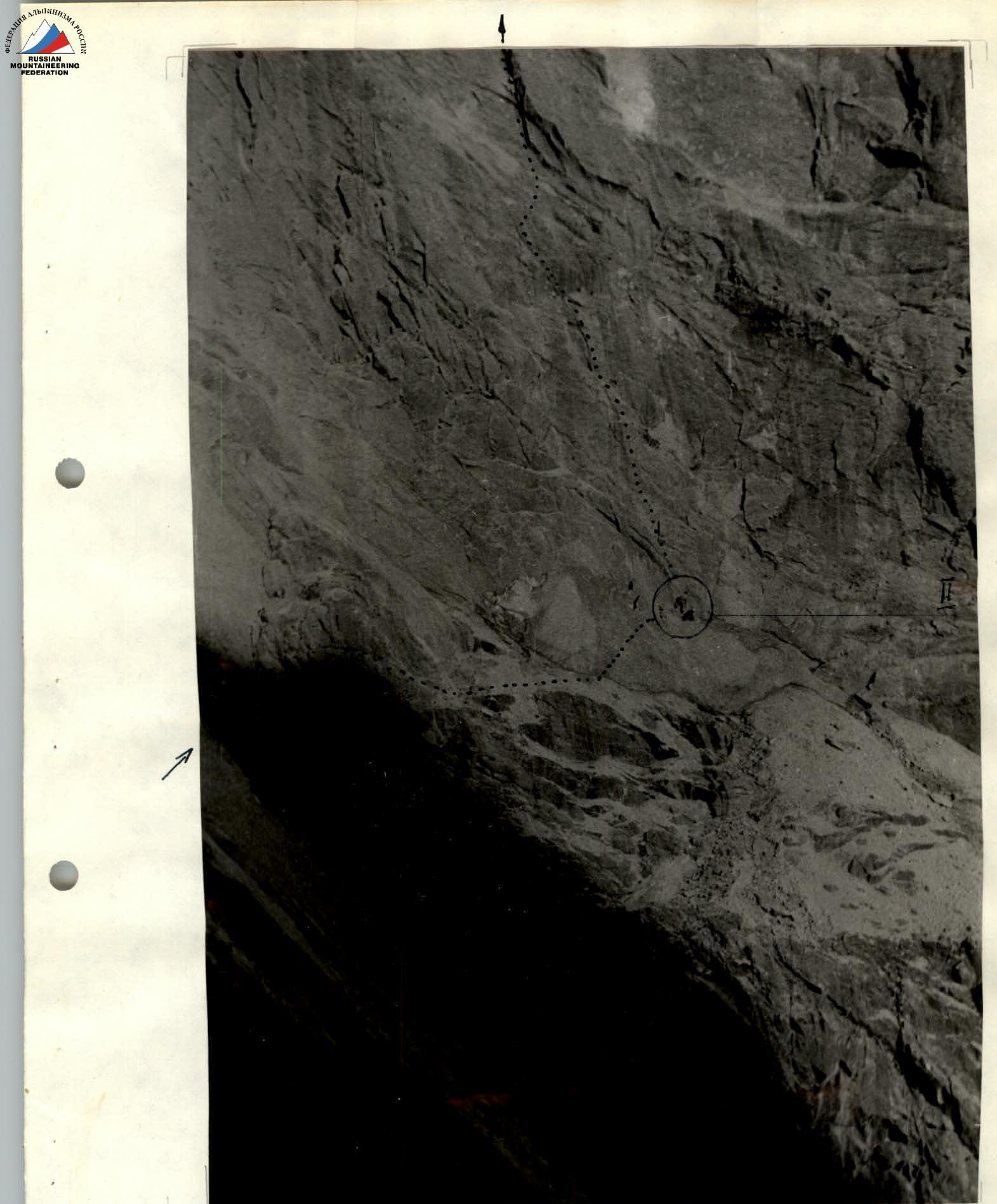
From the summit, descent first to the southeast, and then to the south along a route of the second category of difficulty. To the base camp — 2.5 hours. Croquis of the wall section of the route via the center of the Eastern wall of Peak XXII Olympiad (sections R0–R1, R1–R2, R5–R6).

The first rope team starts working on the wall section of the route, section R2–R3.


