
Central Council of the Zenit Sports Society Protocol No. 396 dated April 15, 1975 5A first ascent (daib)
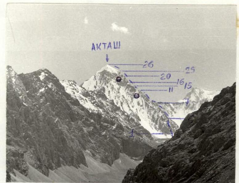
AKTASH — 4937 m VIA THE WESTERN EDGE (first ascent)
Naumov A.F. Master of Sports Galitsky G.S. Candidate for Master of Sports Yekimov S.M. Master of Sports Kozlov Yu.E. Master of Sports Semenov A.N. Candidate for Master of Sports Shelepov V.I. Candidate for Master of Sports
alpl "Dugoba" — 1974
Brief Geographical and Sporting Description of the Climbing Object
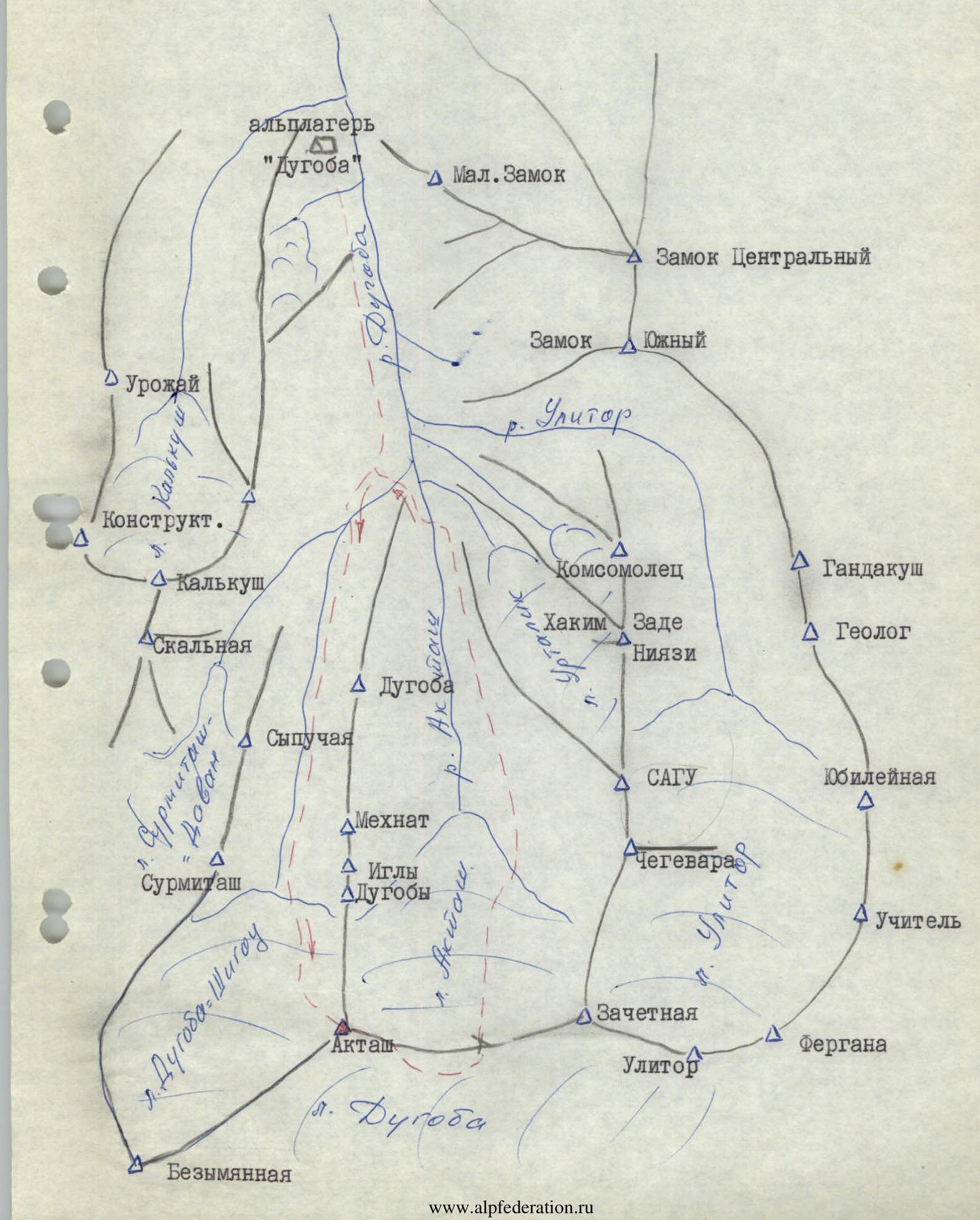
The Aktash peak — 4973 m is located in the Collector Ridge, which is the northern spur of the Alay Ridge. The Aktash nodal peak is the highest point in the alpl "Dugoba" area, situated at the junction of three gorges: Aktash, Dugoba-Shigou, and Dugoba, with glaciers of the same name in their upper reaches. The rivers of the Aktash and Dugoba-Shigou glaciers merge with the Ulitor River to form the Dugoba River, flowing north past the "Dugoba" alpine camp. The river of the powerful Dugoba glacier flows southeast and empties into the Archikhanysh.
The Aktash gorge is the most visited by climbers from the "Dugoba" alpine camp. Three routes to the Aktash peak have been laid from it: 2B, 4A, and 4B categories of difficulty. The Dugoba glacier is rarely visited by camp climbers due to its remoteness, mainly for sporting ascents to Peak Uzbekistan 5B category of difficulty.
To the east in the ridge, beyond the Aktash pass, lies the Zachetny peak, and to the west — the Nameless peak. The northern ridge beyond the Novice pass turns into a long spur with the "Dugoba Needles" and Dugoba peaks.
Until 1974, no routes had been laid to the surrounding peaks from the Dugoba-Shigou gorge. In 1960, a group of instructors from the "Dugoba" alpine camp ascended the northern couloir to the Western edge under the belt of smooth slabs and for unknown reasons did not pass it, descending back via the ascent route. In 1970, a group led by Master of Sports Zhukov, due to the "strong" destruction of the walls at the base of the Western edge and continuous rockfall, did not reach the edge and left the route. Other groups did not enter the Dugoba-Shigou gorge.
The route along the Western edge can be divided into eight parts:
- Lower wall (60–90°) 200–250 m with sections of 4–5 categories of difficulty, many "live" stones, rockfalls are possible.
- Lower part of the edge — ridge (45–50°) 300–350 m, sections of 3–4 categories of difficulty with sections of 2 categories of difficulty.
- "Saw" of numerous gendarmes 150–200 m, sections of 3–4 categories of difficulty with sections of 5 categories of difficulty.
- Middle part of the edge — ridge (40–45°) 250–300 m, sections of 3 categories of difficulty with sections of 2 and 4 categories of difficulty.
- Red gendarme (40–80°) 130–150 m, sections of 4–5 categories of difficulty.
- Belt of smooth slabs (40–90°) 150 m, 4–5 categories of difficulty.
- Belt of four walls (45–90°) 250–270 m, 4–5 categories of difficulty with a section of 6 categories of difficulty — the key section of the route.
- Summit tower-dome 15–20°, section of 1–2 categories of difficulty.
The team spent 30 hours to complete the route, hammering in more than 100 pitons (112). A subsequent team consisting of two Masters of Sports and two Candidates for Master of Sports completed the route in 20 hours, also hammering in about 100 pitons.
The team believes that this route belongs to the 5B category of difficulty, and the second team shares the same opinion.
The weather conditions during the ascent were good, but there were few good days in the season: it mostly drizzled in the camp, and snow fell in the highlands. The poor conditions in the area this year left small sections of ice on the route. Under normal weather conditions, snow and water are completely absent on the route.
Map of the Area
Route Description
The team started the route from a bivouac on the right-bank scree of the Surmetash glacier at 4:00 on August 17 and, crossing a small depression along the scree on the right side of the wide slope, ascended to the base of a wide chimney going up to the right, the rocky base of the Western edge of the Aktash peak.
They ascended the sometimes icy chimney to under the wall and, via a difficult wall, reached a ledge. From the ledge, having ascended a little, they traversed along a steep rocky slope (rockfalls are possible) under the overhanging walls through a wide flat couloir to the left and reached a vaguely defined edge going up. They ascended directly up the wide edge. From the end of the edge, where it turns into a wall, they went to the right wall, with a chimney in the upper part. In the upper part of the wall, there is a difficult exit (ladders) into the chimney, and via a vertical chimney with "live" stones, they reached a site where a tent can be set up.
From the site, the ascent was made along the steep Western edge, bypassing all walls and difficult gendarmes along the slabs on the right side. In the upper part, the edge becomes gentler and turns into a "saw" of numerous simple and difficult gendarmes, separated, as a rule, by sharp notches. Very difficult gendarmes were bypassed on the right along steep smoothed slabs. Beyond the "saw", again along steep, sometimes destroyed rocks of the ridge, bypassing difficult walls and gendarmes on the right, they reached around 17:30 a notch under the Red gendarme. To the right of the gendarme, on a small counterfort, they set up a site for an overnight stay. At the same time, they processed the ascent to the Red gendarme, hanging two ropes. Starting from the processing of the gendarme to the exit to the summit dome, the first one went in crampons.
On August 18, the team started the route at 8:00 and, passing the wall on jugs, ascended in a sporting manner to the top of the Red gendarme. From the gendarme, using sporting techniques and a 10 m rappel, they descended to a wide saddle (the site where the group of instructors reached the edge in 1960). From the saddle, there is a complex ascent along a steep internal angle with numerous "live" stones to the slabs under the overhanging walls, and, having passed 10 m along the slab, an ascent directly up a difficult wall to the next smooth slabs. Along steep slabs alternating with difficult, though short, walls, they ascended with a general direction first up to the right, then up to the left until they reached the Western edge.
Further along the not very steep but heavily jagged, moderately difficult ridge of the Western edge, with short more difficult walls and gendarmes, they ascended under the overhanging walls. Under the walls, along smooth slabs, they traversed to the right to approach a steep, narrow, deep couloir. To the south of the Western edge, many narrow rocky couloirs depart, but all couloirs are subject to frequent rockfalls.
From here, they ascended directly up a vertical, difficult, destroyed in the upper part wall (with sack hauling). From the wall, along a steep slab, they ascended to the right up under an internal angle — a chimney, a vertical smooth wall (the most difficult part of the route). Along a vertical smooth internal angle, with a chimney in the upper part (using ladders, jugs), they ascended to the Western edge, where sacks were hauled. Along the edge, bypassing a small gendarme on a steep slab with a pendulum, they reached a small site on the right counterfort of the Western edge around 17:00. On the site, they set up an overnight stay and simultaneously processed the route with two ropes.
On August 19, they started at 6:00 and, passing a slab and a ridge and on jugs a wall processed the day before, along a steep ridge, approached the last wall of the Western edge. They passed the wall on the left side and along a slab reached the snowy ridge of the Aktash peak dome. And along a simple snowy, sometimes rocky, ridge of the dome, at 10:00, the team reached the summit of Aktash.
The descent was made along the route of 2B category of difficulty, and on the same day, they returned to the "Dugoba" alpine camp.
Table of Sections

| Date of passage | Section designation | Steepness of section in degrees | Length of section, m | Nature of relief | Technical difficulty | Method of passage and belay | Pitons | Free climbing | Time of exit and stop at bivouac |
|---|---|---|---|---|---|---|---|---|---|
| 17.08.1974 | R1–R2 | 45–60 | 80 | chimney, internal angle | 3–4 | climbing | 4 | 4:00 | |
| R2–R3 | 90 | 10 | wall | 5 | 3 | ||||
| R3–R4 | 45–50 | 80 | slope of wide couloir | 3 | 2 | ||||
| R4–R5 | 50–60 | 80 | edge | 4 | 6 | ||||
| R5–R6 | 80–90 | 40 | wall with chimney | 4–5 | ladders | 8 | |||
| R6–R7 | 40 | 300–350 | ridge | 3–4 with sections of 4 | 10 | ||||
| R7–R8 | 25 | 150–160 | "saw" of gendarmes | 3–4 with sections of 5 | 4 | ||||
| R8–R9 | 40–45 | 250 | ridge | 3 with sections of 2–4 | 2 | 17:30 | |||
| R9–R10 | 80–90 | 20 | wall | 5 | ladders | 3 (processed 1) | |||
| R10–R11 | 45–50 | 60–70 | ridge of gendarme | 3–4 | sporting | ||||
| R11–R12 | 45–90 | 80, 10 | ridge, wall | 3–4 | rappel | 10 m | 3 | ||
| 18.08. | R9–R10 | 80–90 | 20 | wall | 5 | jugs | 8:00 | ||
| R10–R11 | 45–50 | 60–70 | ridge of gendarme | 3–4 | sporting | ||||
| R11–R12 | 45–90 | 80, 10 | ridge, wall | 3–4 | rappel | 10 m | 3 | ||
| R12–R13 | 65 | 40 | internal angle | 3–4 | 4 | ||||
| R13–R14 | 90 | 10 | wall | 5 | ladders | 4 | |||
| R14–R15 | 45–90 | 80, 10–15 | slabs, walls | 4–5 | ladders | 10 | |||
| R15–R16 | 25 | 120 | ridge, gendarmes | 3 with sections of 2–4 | 2 | ||||
| R16–R17 | 45–50 | 80 | smooth slabs | 3–4 | 5 | ||||
| R17–R18 | 85–90 | 35–40 | wall | 5 | 8 | ||||
| R18–R19 | 45–50 | 20 | slab | 4 | 2 | ||||
| R19–R20 | 90–95 | 35–40 | wall, internal angle, chimney | 5 with sections of 6 | ladders | 10 | |||
| R20–R21 | 20 | 40 | slabs of gendarme | 4–5 | pendulum | 17:00 | |||
| R21–R22 | 40 | 50 | slabs, ridge | 3–4 | 2 | processing | |||
| R22–R23 | 90 | 35–40 | wall, crevice | 4–5 | 8 | processing | |||
| 19.08. | R21–R22 | 40 | 50 | slabs, ridge | 3–4 | sporting | 6:00 | ||
| R22–R23 | 90 | 35–40 | wall, crevice | 4–5 | jugs | ||||
| R23–R24 | 45 | 60 | ridge | 3–4 | 2 | ||||
| R24–R25 | 80 | 25–30 | wall | 5 | 5 | ||||
| R25–R26 | 20 | 250 | snow-covered ridge | 1–2 | 10:00 |
Comments
Sign in to leave a comment