
Ascent via the North Ridge
The summit of Ak-tash is located in the northwestern spurs of the Alay Range, in the upper reaches of the following glaciers:
- to the southwest — Dugoba,
- to the northeast — Ak-Tash,
- to the northwest — Dugoba-Shigou.
The Ak-tash summit massif consists of heavily fragmented granite and limestone rocks.
Day One
From the "Dugoba" alpine camp, we proceed along the Dugoba River valley to the confluence of the Ak-Tash and Ulitor rivers (2 hours). At the confluence, the trail forks; the further path lies along the left orographic bank of the Ak-Tash River, bypassing a pronounced rocky massif on the right.
The trail leads to a green meadow; after crossing it, we descend to the Surmetash River, and then, traversing the talus and grassy slopes above the left bank of the Ak-Tash River, we reach a canyon-like steep descent to the river (3–3.5 hours from the confluence).
We cross to the right bank of the Ak-Tash River (its width here is 1.5–2 m) and proceed upstream to the terminal moraine of the Ak-Tash glacier (2.5 hours from the canyon). Here, there are bivouac sites.
Thus, from the "Dugoba" alpine camp to the bivouac on the Ak-Tash glacier moraine, it takes 7.5–8 hours of walking time.
Day Two
We traverse the terminal moraine of the Ak-Tash glacier, reach the glacier tongue, and after 40 minutes, we approach the ice slope. Here, we rope up.
Section R0–R1. The ice slope is 55–60° steep and approximately 80 m long. The ascent is made in crampons, with alternating belay in the upper part. Three ice screws were placed, and the section was completed in 45 minutes.
Section R1–R2. Traverse right towards the rocks along the ice slope, with a steepness of 45–60°, reaching 70° in some places, over a distance of 160 m. Movement is done in crampons with step cutting. Belay is alternating, through ice screws. Crevasses are avoided from below. Ten ice screws were placed, and about 100 steps were cut. The section was completed in 2 hours and 30 minutes.
The ice slopes are continuously exposed to rockfall during the day, so sections R0–R1 and R1–R2 must be traversed very early in the morning.
Section R2–R3. A rocky-ice couloir, 60° steep and 60 m long. The section is traversed on the rocks to the right of the couloir. Movement through the couloir is not practical due to the couloir ice being mostly névé. Belay is through rock pitons (6 pieces) and protrusions. The section ends with a small horizontal platform composed of yellow slabs, clearly visible from below. The first control cairn is built here. The time taken for this section is 1 hour and 15 minutes.
Section R3–R4. Rocks of moderate difficulty, 40–50° steep, heavily fragmented. Movement is alternating, with belay through protrusions and rock pitons (10 pieces were placed). The pitons hold weakly. The section ends with a good platform where an overnight stay can be organized. The second control cairn is built here. The time taken for this section is 1 hour and 30 minutes.
Section R4–R5. Difficult rocks, approximately 80° steep and 40 m long. There are very few holds and cracks. Fourteen rock pitons were placed, sometimes as additional support points. Sections covered with névé ice are encountered. The section was completed in 2 hours and 40 minutes.
Section R5–R6. A rocky ridge, about 130 m long, with an average steepness of 30°. The rocks are heavily fragmented and covered with névé ice. Therefore, it is sometimes necessary to move right onto the ice, which is covered with a thin layer (about 10 cm) of snow. Movement on the rocks is simultaneous; on the ice, it is with alternating belay through ice screws (2 pieces). The ridge ends with a large platform where an overnight stay was organized, and the third control cairn was built. The section was completed in 35–40 minutes.
Day Three
Section R6–R7. Rocks of moderate difficulty, 50–60° steep. The section is 140 m long. Belay is through pitons; 15 rock pitons were placed. The section was completed in 2 hours and 10 minutes.
Section R7–R8. (40 m) Smoothed rocks, about 60° steep, covered with névé ice. Movement is done to the right of the rocks on the ice in crampons. About 50 steps were cut. In some places, the ice is covered with a 5–8 cm layer of snow. Belay is through ice screws (4 pieces). The section was completed in 1 hour and 20 minutes.
Section R8–R9. Easy rocks, 45–50° steep (70 m). Movement is simultaneous. The section ends with a small platform before a steep rocky ascent. The time taken for this section is 20 minutes.
Section R9–R10. A wall, about 80° steep, 350 m long. A natural path is clearly visible — a moderately pronounced ridge running through the middle of the wall. The rocks on the left are heavily fragmented, making movement dangerous and unlikely. On the right, the rocks end with an ice wall. Therefore, the ridge is the natural path, and specific landmarks are not indicated. On this section, 20 rock pitons and 4 ice screws were placed, sometimes as additional support points. The time taken for this section is 3 hours and 40 minutes. There are no good rest spots.
Section R10–R11. (150 m) Easy rocks, 30° steep. Movement is simultaneous; after completing the section in 20–25 minutes, we reach a snow slope and then the pre-summit ridge (route 2B category of difficulty) 300–350 m from the summit.
Section R11–R12. A rocky ridge; belay is alternating through protrusions and existing rock pitons (30 minutes).
The descent from the Ak-tash summit is made via route 2B category of difficulty:
- initially along the ascent path,
- then, after a large gendarme, we move down a couloir from the ridge to the Dugoba-Shigou glacier (2 hours).
We proceed along the glacier tongue towards the Ak-Tash pass, ascend the pass via a steep talus slope, and descend along the ice to the moraine of the Ak-Tash glacier. After crossing the moraine, we reach the overnight stay location (2 hours from the Dugoba-Shigou glacier).
Day Four
Return to the "Dugoba" alpine camp.
Thus, the ascent to the summit (excluding approaches) took approximately 17 hours and 30 minutes, and the descent and return to the overnight stay location took 4 hours.
On the route, the following were placed:
- 65 rock pitons
- 23 ice screws.
About 150 steps were cut.
In good weather, the ascent, including approaches, takes 4 days. We do not recommend this ascent for large groups (more than 4 people) as the route is prone to rockfall, and the rocks are heavily fragmented in some places. The most challenging sections are considered to be sections 4–5 and 9–10.
The first ascent was made by a group of instructors from the "Dugoba" alpine camp:
- Zhukov V.M. — senior instructor, 1st sports category
- Tokmakov V.S. — instructor, 1st sports category between July 29 and August 1, 1962.
The group evaluates the route as category 4B difficulty.
(Zhukov)
(Tokmakov)
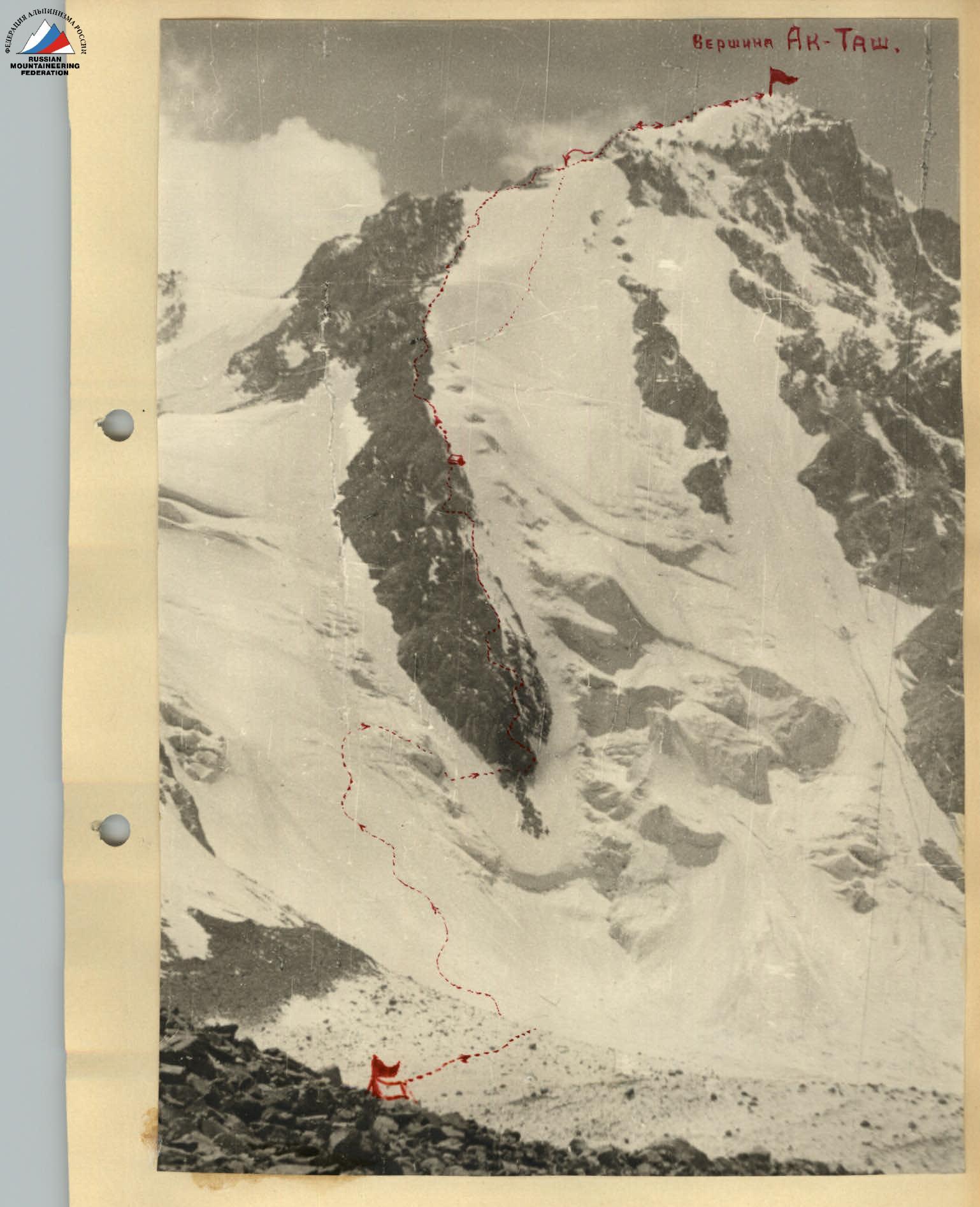
PHOTO 1. The Ak-tash summit and ascent route.
Comments
Sign in to leave a comment