7.16.24. Cat. 4A
Description of the ascent route to Peak 4500 m
"Festival'naya" (from the north, via the pass)
Peak 4500 m is located at the northern tip of the Bayankol ridge, and its eastern slopes descend to the left bank of the Sary-Kaynau River. The peak is situated in a hard-to-reach area of the cirque with very difficult approaches.
From the base camp on the green meadow, located on the right bank of the Sary-Kaynau River, it is necessary to cross to the left bank of the named river. Having crossed the river, we head downstream. After 5 km of walking downstream and rounding several spurs extending from the peak and the subpeak "4500", we reach the foot of the ridge. At the exit of a small mudflow, we turn left and begin to ascend. Up to the middle of the slope, which has a total length of about 1 km, the course of the named mudflow leads, and then - medium and small scree.
On the ridge, the altimeter shows 3800 m above sea level. Leaving a note on the ridge, we begin the technical work of traversing the peak "4500 m".
The first obstacle - a 200 m "gendarme" - required about 3 hours of work. The first 50 m of ascent up the "gendarme" wall are very difficult due to the steepness of the rocks (about 75°), the small number of holds, and cracks suitable for driving pitons. Only 4 rock pitons can be driven in this section. Further, the path becomes somewhat easier, but this is only at first glance. Moving slightly to the right (in the direction of travel), we proceed along a narrow crevice, where the use of piton belay is also difficult. The patches of flowstone covering the ledges are treacherous.
Having reached the right side of the "gendarme" (photo #2), we approach a gently sloping rock wall about 35 m long, after passing which we traverse further to the right and to the foot of a 30-meter chimney with a plug at the exit. Thus, we reach the top of the gendarme from the eastern side. There is almost no opportunity to drive pitons both on the entire wall and in the chimney, but still, we managed to drive 8 rock pitons on the entire "gendarme". We descend from the "gendarme" along a two-tier wall using the "sitting" method, each tier being 10 m. Further, to the "saddle" (not very pronounced) - strongly destroyed medium rocks (see photo #1). The ascent to the subpeak, which has a height of 4250 m, is made along destroyed medium, sometimes difficult rocks with a length of 210 m. Behind the subpeak, the ridge is strongly destroyed, the rocks are not difficult, and in some places, they allow even simultaneous movement (see photo #3). With a total length (in this place) of about 300 m, the ridge descends to the saddle between the subpeak and the peak (more precisely, between the southern and northern peaks). From the saddle, an ascent begins immediately along strongly destroyed medium, sometimes difficult rocks with a length of 60 m, behind which lies a 150-meter snow-ice climb with a steepness of about 50-55°. We spent more than two hours overcoming this section. This climb can be confidently called an ice wall, as the "treacherous" 10-cm layer of snow did not hold the weight of the climber. The exit to the rocks is dangerous due to the risk of falling (a 200-meter rock wall goes down to the left). 10 ice screws were driven in this section. Traversing to the right, in the upper part of the wall, we approach heavily snow-covered difficult rocks with a length of 30 m. Further follows the second snow-ice climb (with a length of 60 m) with a steepness of 45-50°, which we traverse with a gain in height and abut against a 15-meter snow cornice. The cornice in this place overhangs in the eastern and northern directions; it can be bypassed 100 m below along strongly destroyed, snow-covered, difficult rocks. The group decides to cut through the cornice. It takes another 2.5 hours to cut through the cornice and overcome the last ice climb, where 3 ice screws were driven. The exit to the peak along the snowy slope is not difficult but requires careful belay and great caution when moving. Overcoming the last sections of the ascent to the peak and descending from it is done in complex meteorological conditions - continuous cloud cover and snowfall. The descent from the peak to the saddle (4100 m) was made along destroyed rocks, requiring great caution when moving. From the saddle - small, in some places medium scree with a transition to large scree. The ascent is combined in its character. The entire traverse took the group 16.5 hours, i.e., departure from the camp at 6:00 with return at 22:30.
Overcoming all rock sections is very dangerous due to their strong destruction, and passing the subpeak "gendarme" and subpeak is possible only for a small sports group. Considering the peculiarity of this area - that bad weather starts in the second half of the day - it is necessary to start the ascent at 2-3 am, making approaches by the light of a pocket flashlight, and begin work on technical sections at sunrise (or make the ascent in two days).
The traverse of the peak "4500" from north to south was first made by a sports group of the Kazakh Republican Alpine Club on August 4, 1957, consisting of:
Mansurov Babir - leader,
members - B. Krasilnikov, Nebogin, A. Tarasenko.
We determined the difficulty of the traverse as Cat. 4A.
The description was compiled by B. Mansurov. 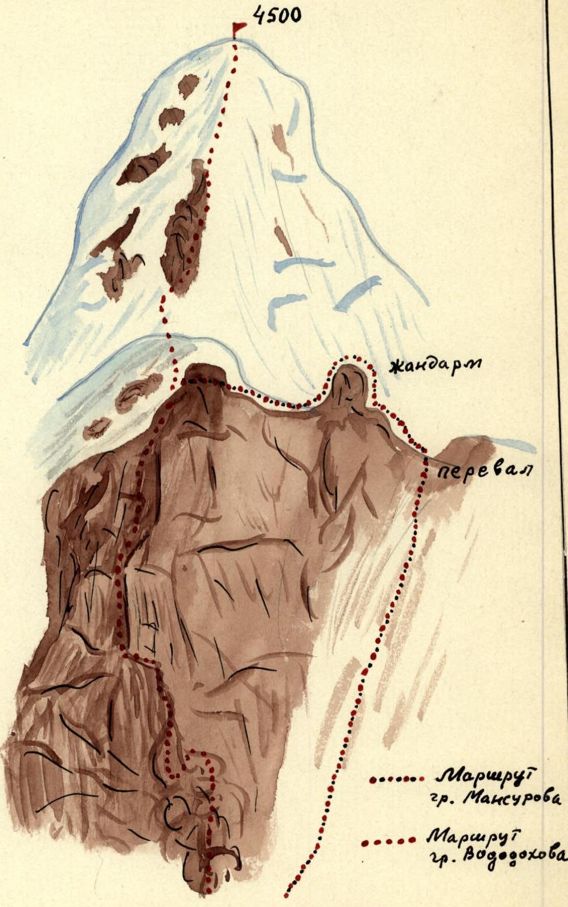
View of Peak Festival'naya