Ascent Passport
- Ascent class - high-altitude technical
- Ascent area - Central Tian-Shan, North Inylchek Glacier
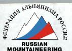
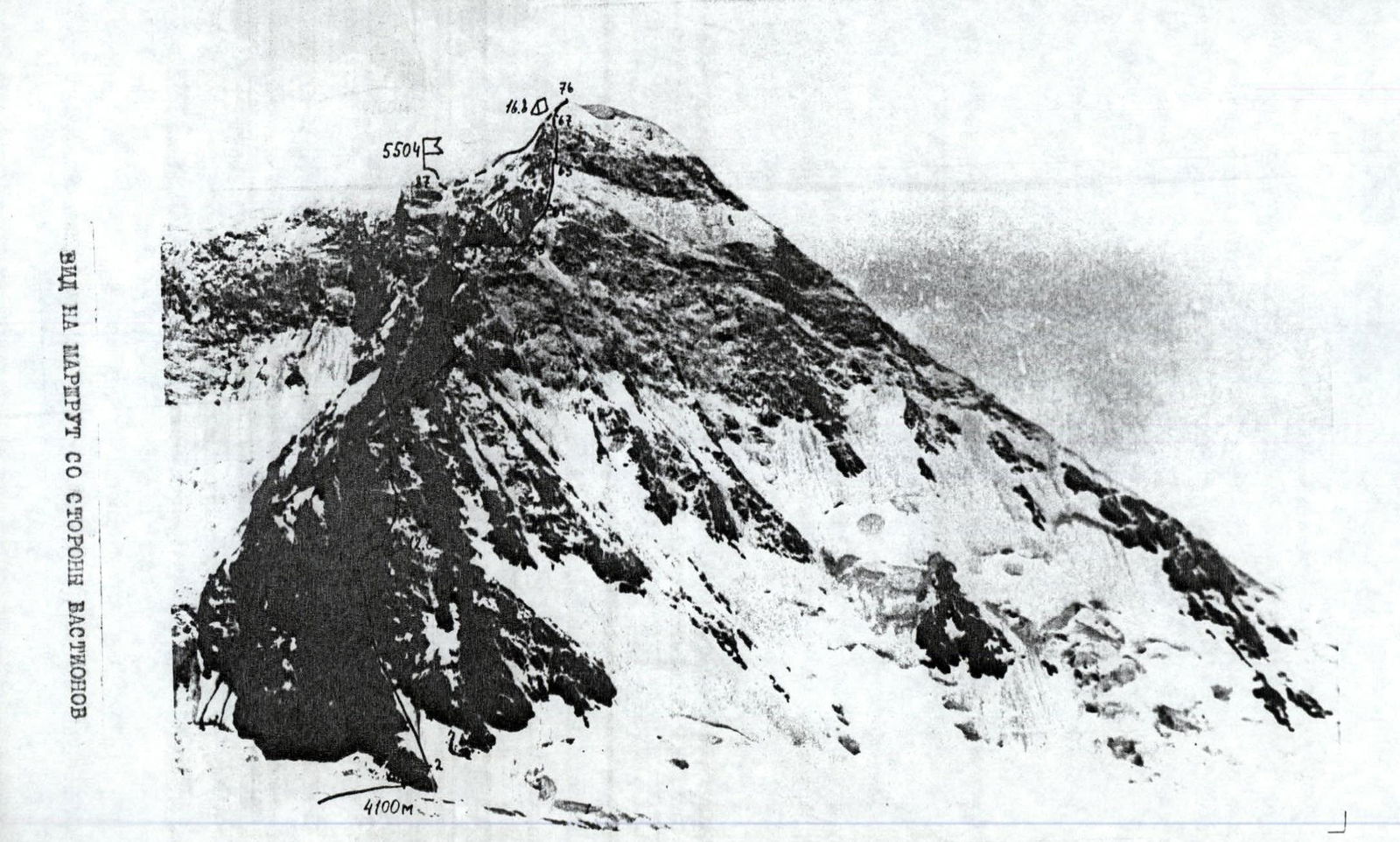
- First ascent route - Pik Trekhlavy (5504), North-Eastern ridge
- Estimated difficulty category - 5B
- Route characteristics:
height difference - 1400 m average steepness of the difficult section - 56° average steepness - length of the difficult section U-UI cat. diff. - 900 m route length - 3000 m
- Pitons hammered: rock - 153, ITO - 3
ice - 37, bolted - none, chocks - 40
- Number of climbing hours - 63
- Number of nights and their characteristics:
- 6 nights
- all lying down
- Team composition:
Pletnikov Andrey Evgenievich - CMS, captain Vodopyanov Sergey Konstantinovich - CMS Eremin Vladimir Viktorovich - 1st sp. category Prokopenko Vladimir Ivanovich - CMS
- Team coach - Prokopenko Vladimir Ivanovich, MS
- Dates of departure and return:
- August 12, 1980
- August 18, 1980
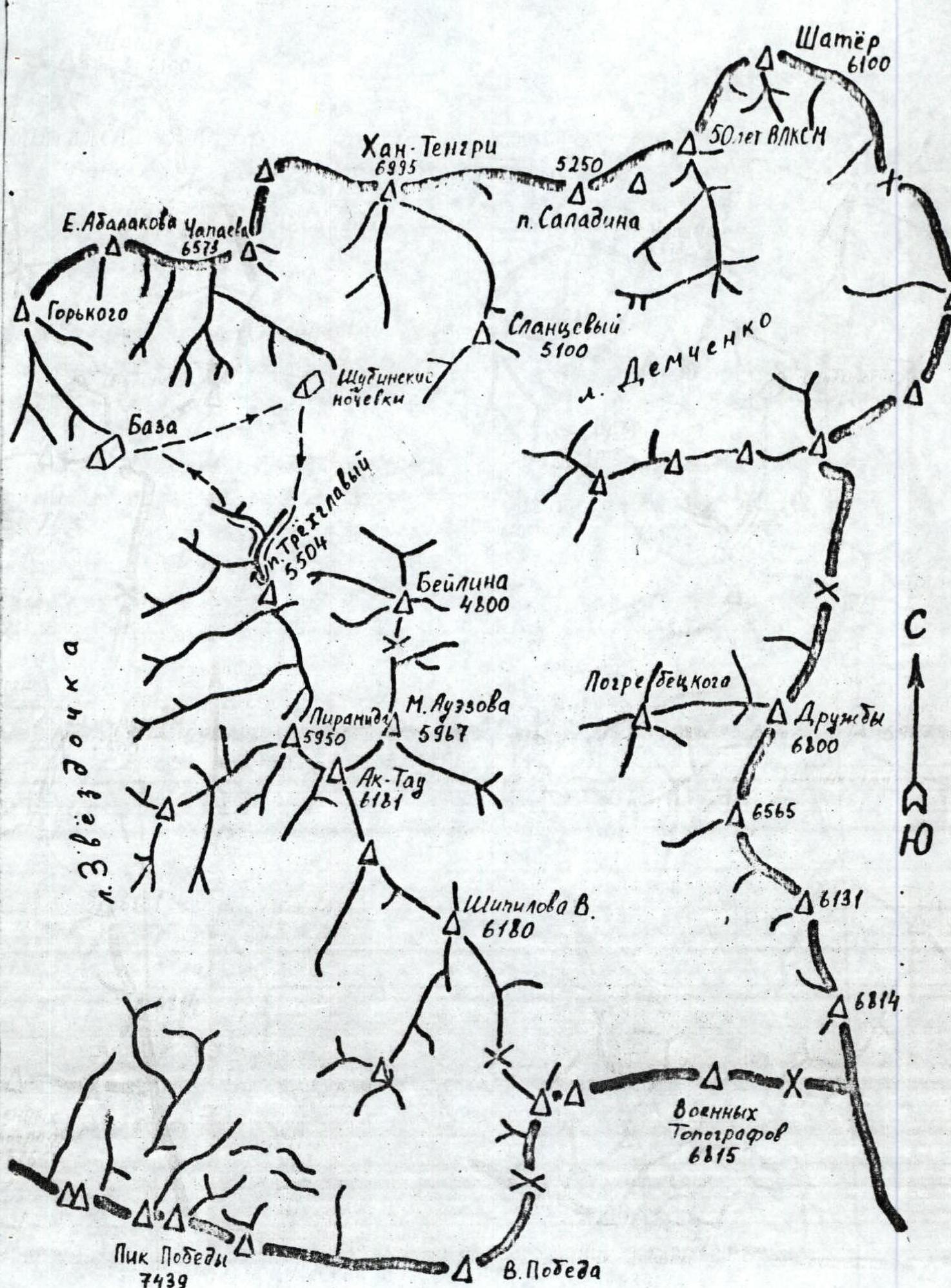
Area Map
Ascent Description
The route begins above the icefall at the confluence of the lateral glacier and Inylchek at the lower edge of the rocky "paw". Exit to the rocks through the bergschrund via a snow bridge.
Section O-1. Along the inclined rocky ledge to the right. Piton belay and protection through protrusions.
Section 1-2. Up the internal corner directly to the ice slope.
Section 2-3. In crampons straight up to the right of the rocky protrusion and then along the left rocks. Belay through ice screws.
Section 3-4. Along the inclined snow-ice ledge.
Section 4-5. To the left of a large stone up a vertical rocky internal corner, turning further into a steep couloir filled with ice.
Section 5-6. On a small rocky ledge under the overhanging cornices, the first control cairn.
Section 6-7. In the left part of the ledge, an overhanging rocky cornice is passed head-on using ladders.
Section 7-8. Straight up the rocky cleft with piton belay.
Section 8-9. A small ledge with a convenient place for belay organization.
Section 9-10. Along the continuing cleft with a series of short but steep walls.
Section 10-11. Ledge with a large stone stuck in the cleft.
Section 11-12. From the stone to the right along the chimney with a plug, bypassed on the right side.
Section 12-13. Ledge convenient for bivouac organization. The group equipped a horizontal platform for a tent. The second control cairn is set.
Section 13-14. In the first part of the ledge up a vertical crack to a small ledge.
Section 14-15. Along the rocky slope under the rocky wall.
Section 15-19. Steep rocks. Possible to pass straight up. Due to the snow fallen the day before, several short traverses to the right and left were made. Climbing is difficult.
Section 19-22. Along a faintly expressed ridge and further along the internal corner leading to a rocky wall, exiting to a ledge.
Climbing 4-5 category of difficulty.
Section 22-23. A small ledge under large rocky overhangs. Convenient for a short rest with a snack.
Section 23-24. Up a steep rocky wall under the overhangs. Climbing is difficult due to the lack of holds.
Section 24-27. Along a small ledge to the left behind the ridge. Further through a small wall and a destroyed couloir, leading to the top of the first bastion.
Section 27-29. Along the destroyed ridge, becoming more complicated as you move forward under the red wall.
Section 29-30. Up a steep wall with a small traverse to the right in its middle part.
Section 30-31. Horizontal section on the ridge. In its middle part, a horizontal platform for a tent is cut out in ice and shale.
Section 31-32. Traverse to the left from the ridge to a small ledge with a convenient place for belay organization.
Section 32-33. From the ledge up the internal corner with an overhang in the upper part using ladders.
The passage of this section by one of the participants along the rope is shown in the photographs (see photo).
Section 33-34. A sheer slab approaches the next key section of the 2nd bastion.
Section 34-35. Represents a cleft with an overhang. In crampons, this section is passed without artificial footholds, using "chocks".
Section 35-36. Convenient for belay and rope pulling, a small ledge.
Section 36-37. An almost vertical wall has few holds. In several places, it was possible to use "chocks".
Section 37-40. After a small ledge follows a rocky wall, leading to the top of the 2nd bastion. The third control cairn is built here.
Section 40-41. Represents a sharp ridge with a jagged relief.
Section 41-42. The wall in the ridge is overcome straight up. The overhang in the upper part is bypassed on the right side.
Section 42-43. Snow-ice section is passed with belay through ice screws.
Section 43-46. Two successive rocky walls lead to a "room" between three large stones. A horizontal platform for a tent is equipped here, protected from the wind on all sides.
Section 46-50. An easy ridge leads to two rocky walls, following one after another.
Section 50-58. The saddle before the 3rd bastion is formed by a powerful cornice. Pass under the cornice on the left side, and then exit onto the cornice through a window.
Section 53-61. Represents a series of rocky walls, filled with ice and dusted with snow. Belay is difficult. Great care and attention are required here.
Section 61-63. Snow and ice become more abundant. It becomes possible to use ice screws for belay. Walls are encountered in places. Along the steep ridge with ice, approach under the overhanging wall.
Section 63-66. Under the wall, a difficult traverse to the right into a couloir filled with ice. Up the couloir along a rocky outcrop in its middle part, and then, sticking to the left side along the rocks, exit to the ridge.
Section 66-67. Along the snowy ridge through a small wall. On a faintly expressed shoulder on the ridge, a platform for a tent is cut out in the ice.
Section 67-76. Represents a series of powerful snow cornices, breaking off to the east. Snow is loose, laborious. Finally, the ridge leads to a snowy shoulder, representing a large snow field. Leave bivouac equipment.
Section 76-79. In the direction of the summit, a fairly wide ridge goes, breaking off to the left with huge snow-ice cornices. Cracks are often encountered.
Section 79-80. The ridge leads to a steep snow-ice ascent, belay through ice screws.
Section 80-83. Through ice breaks, along deep snow, approach under the summit ice tower.
Section 83-84. The path to the tower is blocked by overhanging ice walls formed by breaks. The passage in the lower part is a 5-meter wall.
Section 85-86. Traverse to the left to the break in the ridge. Snow is loose. The first one up to the chest in the snow digs a trench. At the edge of the southern exposure, the snow is firmer - belay through an ice axe is possible.
Section 86-87. From the break again up. The trench is dug up to the very summit.
The first summit of Pik Trekhlavy is lower than the second and not lower than the third. Leave a note in a vitamin jar on the dome. Descent along the ascent route to the bivouac equipment on the snowy shoulder. Further descent along the North-West ridge towards the first rocky island. On the rocks, a Dolpher loop of 80 m is left. Further descent along the ice along the edge of the ridge. About 20 ropes of 80 m. Belay through ice screws. The last one - with lower belay. About 60 screws are wrapped up.
In the lower third of the ridge, the group, leaving an ice screw with a loop in compacted firn, descended to the right along the snow slope and then onto the Inylchek Glacier.