
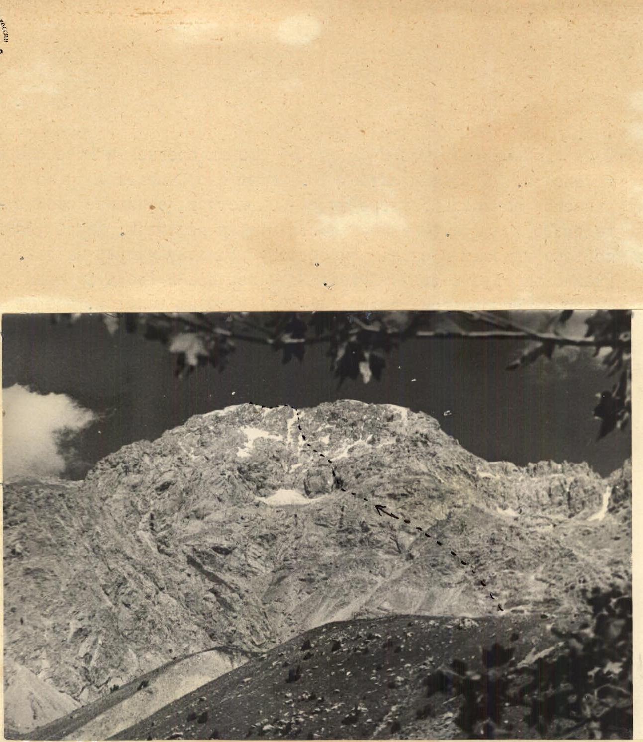
Bau-besh-ata, 4485 m, 2B. Location: pr. 120905.15/3-637. Compiled by: Nekrasov G.
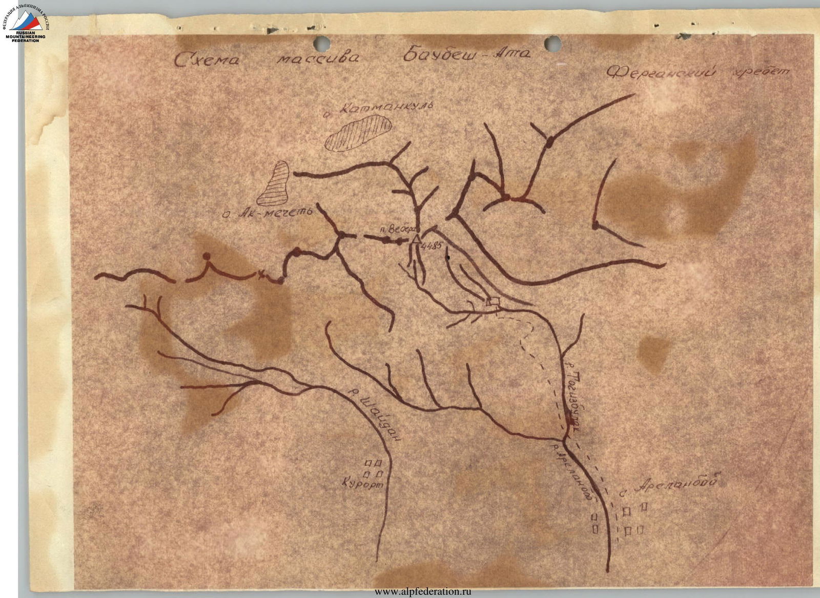
To the north of Jalal-Abad city, above the north-eastern edge of the Fergana valley, rises the Bau-besh-ata mountain massif. The highest peak of this massif is Peak Weber (Bau-besh-ata or Bak-bash-ata), named after a prominent Soviet geologist-academician.
The foot of Peak Weber, like the entire Bau-besh-ata massif, is covered with walnut forests - the largest walnut forests in the world.
The main watershed of the massif, which also passes through the peak, branches off from the main ridge of the Fergana range to the southwest, thus forming a separate spur. The entire massif is composed of limestone (marbleized) with a monolithic structure.
Approaches
From Jalal-Abad, you can drive by car through Bazar-Kurgan and along the Kara-Utur river to the famous Arslan-Bob tract in Central Asia. From Arslan-Bob, you need to walk north along the Arslan-Bob river on a trail. In the upper reaches, the trail crosses to the left bank (orographically) and heads east. The trail leads to a grassy plateau located directly under Bau-besh-ata. The base camp should be set up on the plateau near one of the springs.
Ascent Route
From the base camp, we ascend along the grassy slope to the right towards the ridge. The altitude gain along the grassy slope is 200–250 m. There are rock outcrops on the ridge. We follow the ridge north and reach a scree slope, and then below the rocks. We ascend the rocks by 5–6 m and then move to the right and up along a wide ledge, bypassing large rocks. After 30–40 m of ascent, we enter a couloir. The ascent along the couloir is on scree. The width of the couloir is 2–3 m, the steepness is 30–35°. After 10 m, the couloir abuts against steep rocks.
We move to the right along the ledge for 10 m and then ascend to the left up the rocks for 15–20 m. We enter the couloir again and ascend 12–15 m along its steep grassy bottom. Then we ascend another 20 m along easy rocks and move to the right. After 25 m of walking, we reach the ridge and enter the next couloir. The width of the couloir is 10–15 m, the steepness is 35–40°, simple rocks, and scree in places. After 40 m of ascent along the couloir, we reach the ridge. Then we follow a gentle ridge for 30–40 m. After this section, we move to the right along ledges to bypass steep rock outcrops. After 50–60 m, we reach the ridge again and continue along it on easy, broken rocks (70–80 m). We reach a wide scree ridge (scree mixed with clay). We ascend the scree slope towards the rocks. At first, the gentle ridge becomes steeper. In the second half, the ridge is represented by red scree. The length of the scree section is 350–400 m. Then we ascend along the scree along the "ram's foreheads" towards the rock massif. A narrow snow-ice couloir descends from the rock massif. To the right of this couloir, there is an scree couloir with a length of 30–40 m. The couloir is not steep and leads to the ridge, from which we descend into the next couloir. This couloir is adjacent to the snow-ice one. The steepness of the couloir is up to 40°, the length is 75–85 m, rocks of medium difficulty. The couloir ends with a sheer wall. 20 m before it, we exit to the left onto the ridge and move along wide ledges along the rock walls. We pass 100 m along the ledges to the ridge running south.
In the opposite direction, the ridge ends in a wall. 10 m before the ridge, we turn to the right into a cleft with a steepness of 45–50° and a length of 40–50 m. The bottom of the cleft is covered with snow, and in the upper part - with ice. Having passed the cleft, we turn to the left and ascend up the rocks of medium difficulty. The steepness of the rocks is 50°. Having ascended 30–40 m, we turn to the right and ascend along the wall with a length of 15–17 m onto a ledge. Here begins the key section of the route. The first 3–4 m of the path pass along an inclined slab. The slab is wet, there are no holds. Then follows a sheer 40–50 m wall with a chimney. You need to move along the chimney. The rocks are wet. This section requires careful piton belay. The chimney ends with a plug, which is bypassed on the right.
The further path passes along rocks of medium and below medium difficulty. Along the rocks for 20 m. Then we turn to the right and move along the rocky ridge for 80–100 m to the beginning of the snow-ice couloir. In the lower part, the couloir is not steep. After 50–60 m of ascent, we reach a rocky island dividing the couloir into two. We turn into the right branch of the couloir. We always walk along large rocks. The couloir ends with a steep (45–50°) ice ascent covered with a thin layer of snow. The length of this section is 50–60 m. We exit along this ascent onto the ridge. To the north, the ridge ends in an ice wall. To the south, it descends steeply, first an ice slope, then rocky walls. We walk west along a relatively sharp ridge. After 100–150 m, we approach a wide crevasse. We pass on the left side of the crevasse. We enter a depression. On the left is a rocky ridge, on the right - an ice one. We move along the depression, sometimes exiting onto rocks. The length of this part is 300–350 m. It abounds with small ascents and descents. We exit below a steep snow ascent, turning to the right, with a length of 50–60 m. Along this ascent, we reach the sub-peak. Another 40 m along the ridge to the north and the summit. The entire ascent to the summit takes 9–10 hours. The descent to the ridge, from which we exit into the snow-ice couloir, follows the ascent path.
The further descent follows the same couloir, first snowy, then scree. The couloir is divided into several branches. We turn into the rightmost one and descend along it to the "ram's foreheads". The length of the "ram's foreheads" section is 50–60 m. When descending along them, careful belay should be applied. From the "ram's foreheads", we descend onto a gentle glacier (90–100 m) and then onto scree. Along the scree, we pass to the right. We bypass a large gendarme and ascend to the pass. Then the descent down along small and medium scree to the base camp. The descent takes 3–3.5 hours.
In the opinion of the group, the route is of certain interest in sports terms and is a 3B category route.
Crema Macuba
Gaver - May 4
- Депеанкель шпер
- Камманя
- М
- Ак-мерцемо
- Беанс
- Кюром
- Спецавтобус
- И
- И