I. Climbing Passport
- Climbing category: technical.
- Climbing area: North-West Tian Shan, Talas Alatau range.
- Peak, its height, climbing route — South Manas 4512 m, via the north face of the eastern ridge.
- Estimated difficulty category: 5A.
- Route characteristics: height difference 1000 m. Length of sections 5–6 km/tr. 365 m, average steepness 60°.
- Pitons used: for rock protection — 65; for creating rock ITO — 4.
- Total climbing hours: 30 hours.
- Number of nights and their characteristics: one night on the wall, semi-reclined for four people.
- Surname, name, patronymic of the leader, participants, and their qualifications:
under the guidance of Troshchinenko L.A. — Master of Sports of the USSR, consisting of:
- Glushkovsky A.E. — Master of Sports of the USSR
- Koren A.V. — II sports category
- Ivanov A.K. — II sports category.
- Team coach — Troshchinenko L.A. — Master of Sports of the USSR.
- Dates of departure and return: May 9, 1981 – May 10, 1981.
II. Schematic map of the climbing area
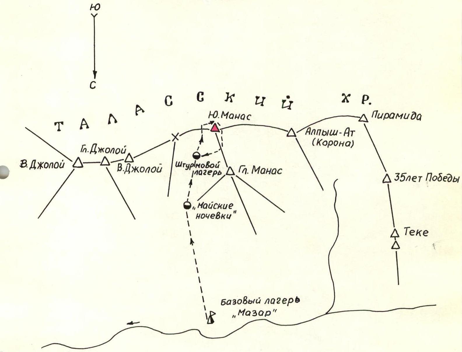
Legend: → group path
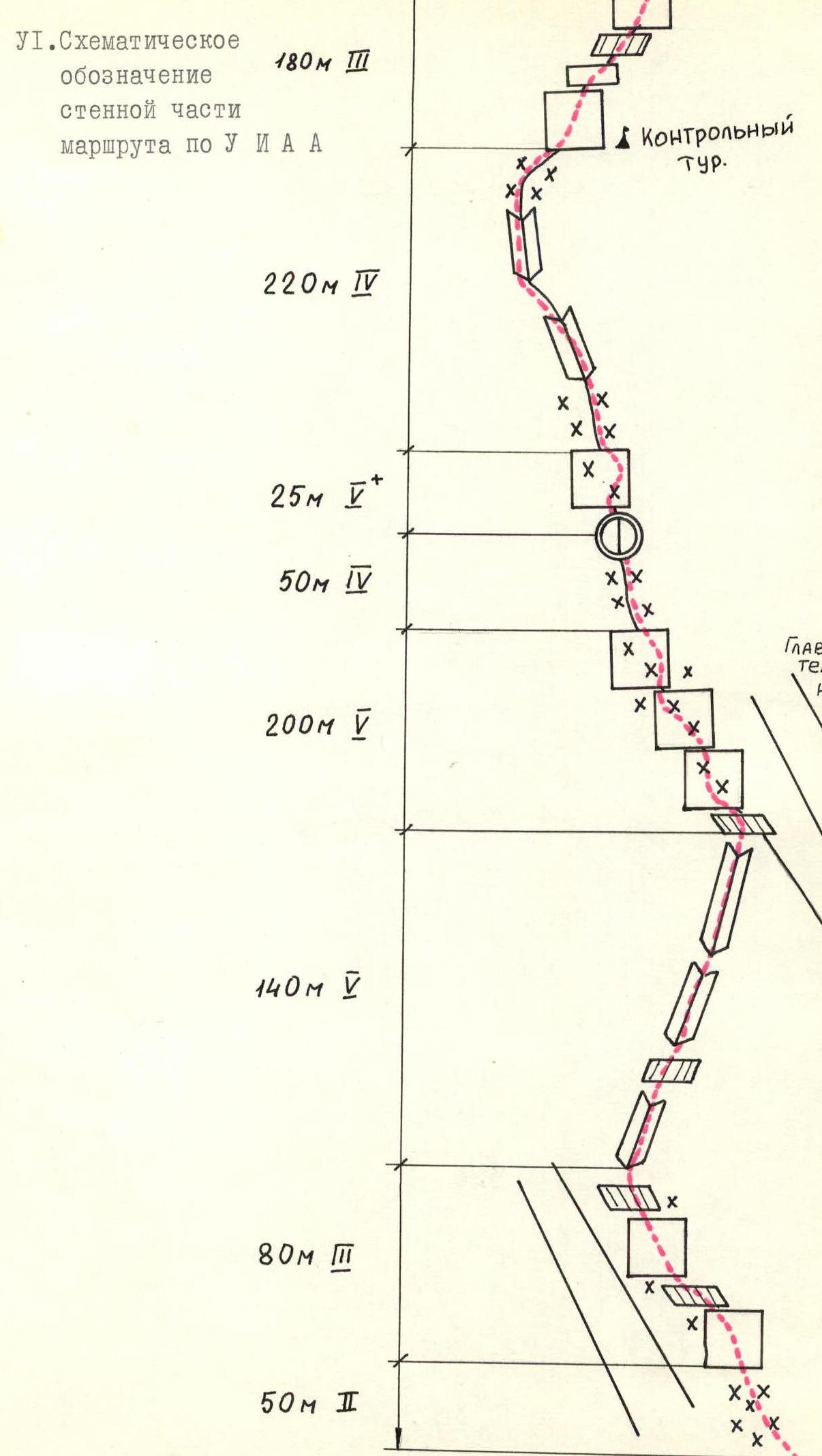
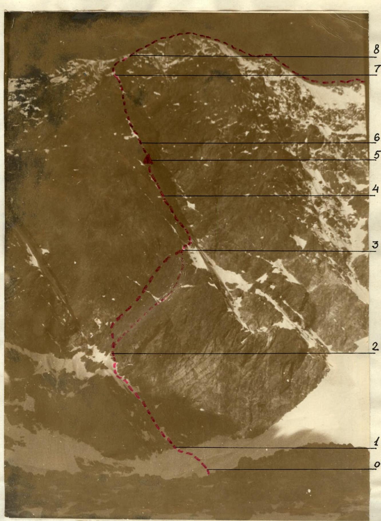
Fig. 1. Wall section of the climbing route.
III. Brief description of the approach to the climbing route on South Manas peak (4512 m) via the north face of the eastern ridge (5A category)
From the "Mazar" base camp, 3–3.5 hours of hiking uphill along the trail to the "May" campsite under the slope of Manas peak. Elevation mark of the campsite according to the altimeter: 3300 m. From the "May" campsite, 1.5–2.0 hours uphill along the moraine under the north face of the eastern ridge of South Manas peak. Location of the assault camp (on the moraine). The object of the ascent is the black rock wall dominating the center of the north slope of the eastern ridge, with a characteristic rock-ice couloir dividing the wall from left to right downwards into two parts. The climbing route first passes through the left part of the wall, then along its edge, exiting onto the eastern ridge and further to the summit of South Manas (see Fig. 1, 2).
IV. Table of main characteristics of the climbing route
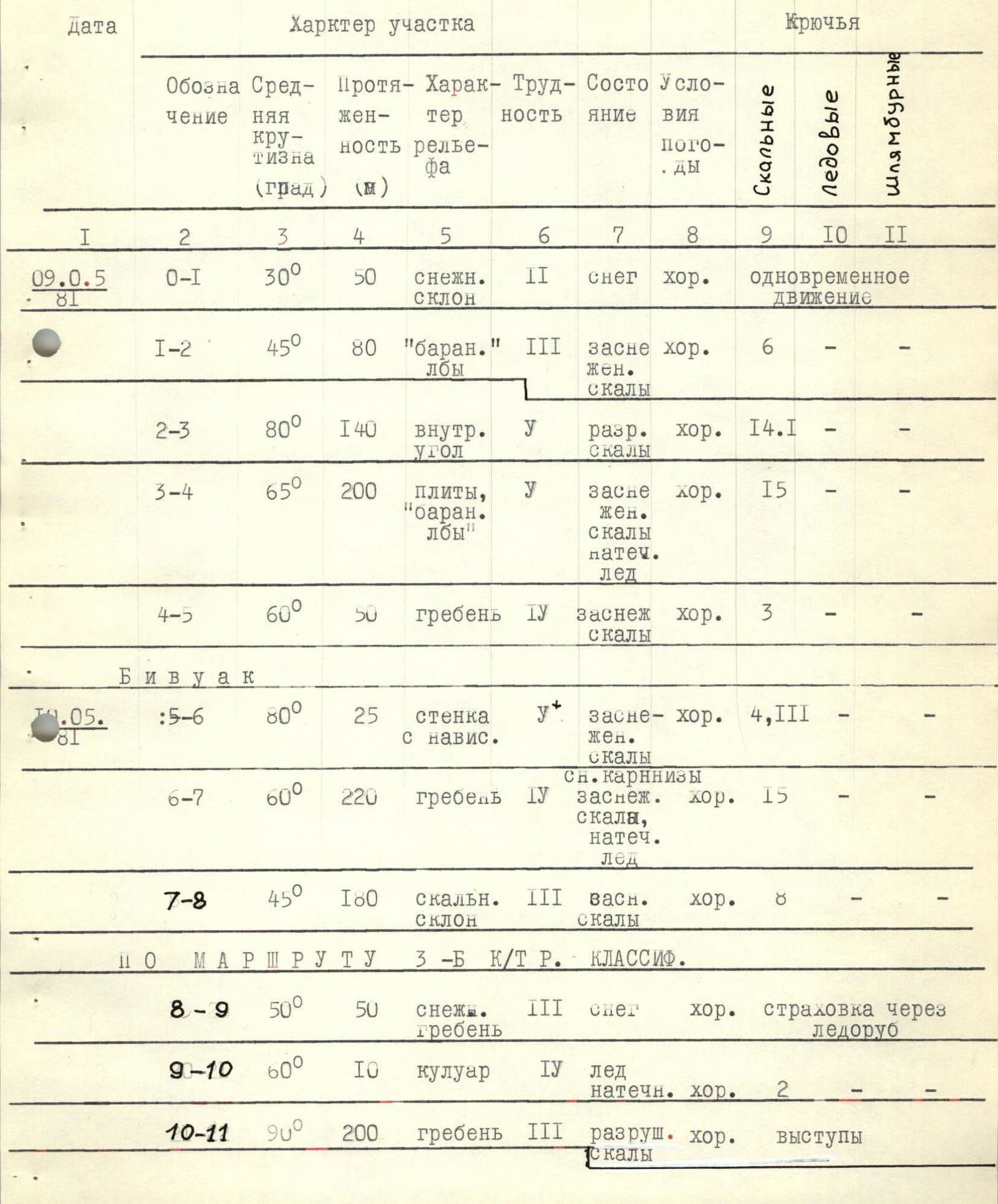
| Date | Designation | Avg. steepness (deg) | Length (m) | Terrain type | Difficulty | Condition | Weather conditions | Rock pitons | Ice pitons | Bolts |
|---|---|---|---|---|---|---|---|---|---|---|
| 09.05.81 | R0–R1 | 30° | 50 | snow slope | II | snow | good | simultaneous movement | ||
| R1–R2 | 45° | 80 | "ram's foreheads" | III | snow-covered rocks | good | 6 | |||
| R2–R3 | 80° | 140 | inner corner | V | fractured rocks | good | 14 | 1 | ||
| R3–R4 | 65° | 200 | slabs, "ram's foreheads" | V | snow-covered rocks, ice | good | 15 | |||
| R4–R5 | 60° | 50 | ridge | IV | snow-covered rocks | good | 3 | |||
| 10.05.81 | Bivouac | |||||||||
| R5–R6 | 80° | 25 | wall with overhang | V+ | snow-covered rocks | good | 4 | III | ||
| R6–R7 | 60° | 220 | snow cornice, snow-covered rock, ice | IV | good | 15 | ||||
| R7–R8 | 45° | 180 | rocky slope | III | snow-covered rocks | good | 8 | |||
| via 3B category route | classified | |||||||||
| R8–R9 | 50° | 50 | snowy ridge | III | snow | good | protection via ice axe | |||
| R9–R10 | 60° | 10 | couloir | IV | ice, ice crust | good | 2 | |||
| R10–R11 | 90° | 200 | ridge | III | fractured rocks | good | ledges | |||
| R11–R12 | 45° | 200 | ridge | IV | fractured rocks | good | 5 | ledges | ||
| R12–R13 | 60–70° | 120 | wall | IV | monolith | good | 12 | ledges | ||
| R13–R14 | 30° | 220 | ridge | II | fractured rocks | good | simultaneous movement | |||
| R14–R15 | 80° | 20 | wall | IV | monolith | good | rappelling with rope retrieval | |||
| R15–R16 | 40° | 80 | ridge | III | fractured rocks | good | ledges |
V. Brief explanation of the table of main characteristics of the climbing route
R0–R1. Traversing the snow slope at the base of the wall. Can be rockfall-prone. Ice falls possible in summer. R1–R2. Start of the route. Up and left along "ram's foreheads". Piton protection, exit under the system of inner corners going up and right. Rocks are monolithic. R2–R3. Up and right through the system of inner corners. Rocks are fractured, few places for piton placement, good use of chocks and slings. Use of quickdraws necessary. Section ends with an exit to the edge of the left part of the wall (main dividing rock-ice couloir, see I–II). R3–R4. Along slabs and "ram's foreheads" along the edge of the wall. Few places for piton placement, difficult to use chocks. Rocks are covered with loose snow, often with ice crust. At the end of the section, the edge of the wall becomes pronounced. R4–R5. Along the ridge to a characteristic rise. The rise is a 25–30 m wall with a snow cornice attached. Can accommodate four people on the cornice. Can hammer in reliable pitons for protection and for the tent. First possible bivouac site. Next suitable site — at the end of section R6–R7. R5–R6. Key location. Small traverse (5–6 m) rightwards along the wall with a slight overhang — exit to the ridge. Piton protection, chocks. Quickdraws necessary. Ice crust encountered, rocks are covered with snow. R6–R7. Straight up along the ridge. Piton protection, through slings thrown over ledges. Control cairn at the end of the section. R7–R8. Rocky slope, alternating: wall – ledge.
- Rocks are snow-covered
- Ledges are snowy Protection is mainly through chocks. Exit to the eastern ridge. Further along the 3B category route, classified.
Recommendations for climbers:
- Ascent is advisable for a group of no more than 4 people.
- It is necessary to have an extensive set of chocks, as well as quickdraws.
- Passage of section R0–R1 should be done in the morning hours (rockfall-prone).
VI. Schematic representation of the wall section of the route according to UIAA