Ascent Log
-
Ascent category — technical
-
Ascent area — NW Tian Shan range, Talas Alatau range
-
Peak, its height, ascent route — South Manas 4512 m via the right buttress of the north face of the eastern ridge
-
Expected category of difficulty — 4A
-
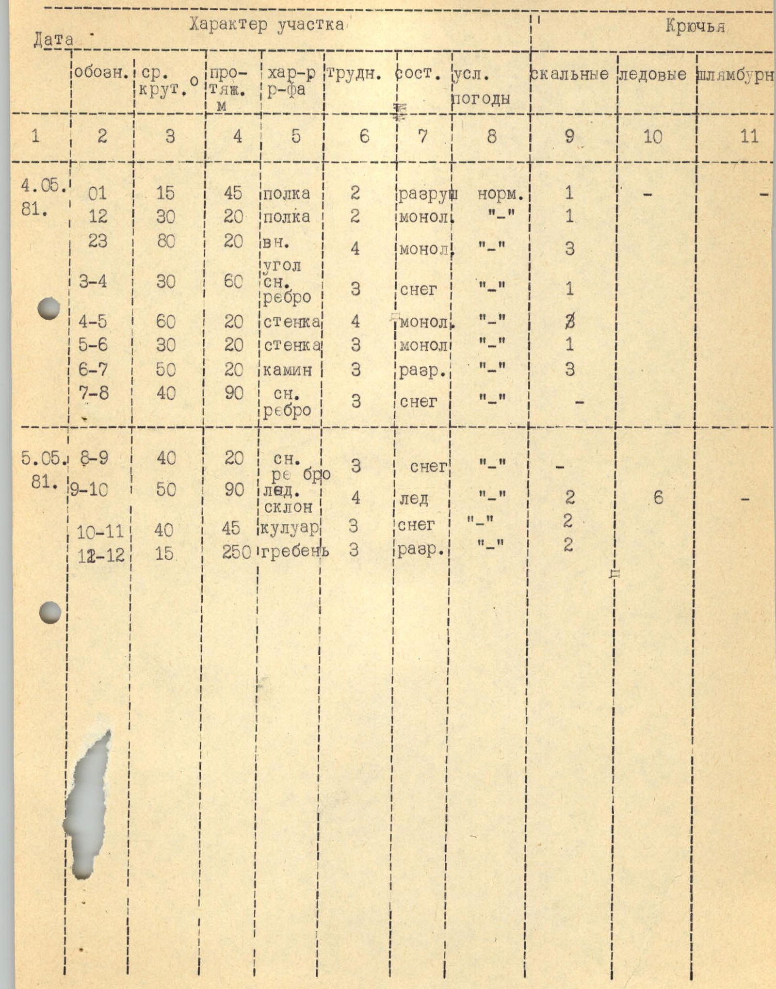
Route characteristics: height difference 650 m
Length of sections 5–6 km/tr. — none, average slope 45°–50°
-
Pitons hammered in: for rock protection 19, ice screws 6, for creating anchor belay rock 1
-
Number of climbing hours 15
-
Number of nights and their characteristics: 1 overnight stay on a snow site, lying down for four people
-
Surname, name, patronymic of the leader, participants, and their qualifications:
Led by Zayonchkovsky A.Ya. USSR Master of Sports, consisting of:
- Golubtsov S.G. 2nd sports category
- Makelnikov A.A. 2nd sports category
- Fomin O.A. 2nd sports category
-
Team coach Troshchinenko L.A. USSR Master of Sports
-
Date of departure and return May 4–5, 1981
-
Brief description of the approach to the route: ascent to South Manas peak (4512 m) via the right buttress of the north face of the eastern ridge (4A category of difficulty)
From the "Mazar" base camp, 3–3.5 hours of walking uphill along the trail to the "May" overnight stay under the slope of Manas peak. Altitude mark of overnight stay according to the altimeter 3300 m.
The location of the assault camp (at the "May" overnight stay). The object of the ascent is the buttress, to the left of the ice slope, ending below with a pronounced shoulder.
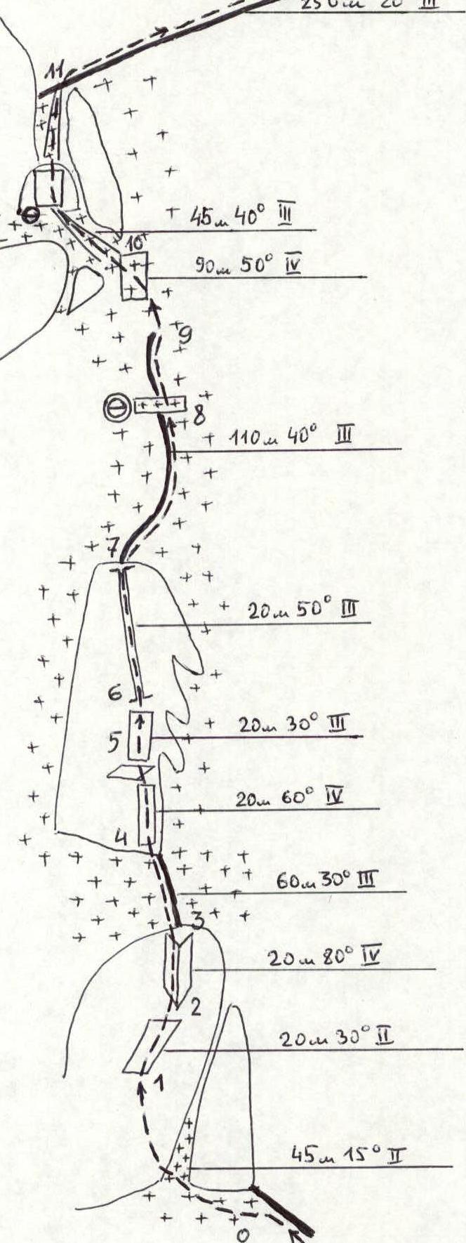
The ascent route passes along the shoulder, then along the buttress, emerging onto the eastern ridge and further to the South Manas peak (see Fig. 1)
-
Table of main characteristics of the ascent route.
-
Brief explanation of the table of main characteristics of the ascent route
Section R0–R1. Traverse of a snowy (with rock outcrops) couloir to the base of a rock wall.
Section R1–R2. Ascent along slabs to a pronounced wall.
Section R2–R3. Via a wide crack or internal angle — ascent upwards.
Section R3–R4. Snow ridge with rock outcrops. Approach to the base of a rock wall.
Section R4–R6. Ascent along the wall and rock ledges to the base of a snow-filled couloir (possible ice). Control cairn.
Section R6–R7. Ascent up the couloir. In the upper part, the rocks are destroyed.
Section R7–R8. Snow ridge with rock outcrops. At the end, there is a snow area suitable for an overnight stay.
Section R8–R9. Ascent towards the ice slope.
Section R9–R10. Ascent along the ice to the left, upwards — to a rocky cape. On the rocks, there is a convenient ledge for belaying.
Section R10–R11. Approach along the snow to a 3-meter wall and further along a wide snow couloir — exit onto the ridge.
Section R11–R12. Along the classified route of 3B category of difficulty — to the summit.
Recommendations for climbers:
-
Time of departure from the assault camp — no later than 7:00.
-
Stop for a bivouac — at 19:00.
UIAA scheme.

-
-
Appendices.

Fig. 1. On section R0–R1.
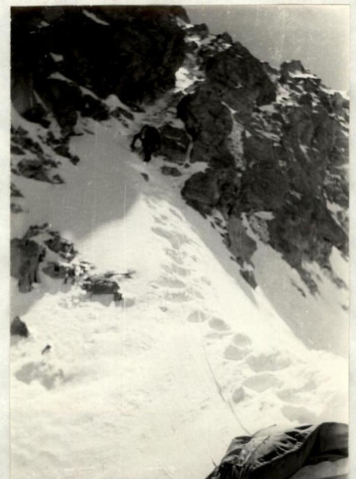
Fig. 2. On section R6–R7. Shot from the control cairn.

Fig. 3. View of South Manas peak from the overnight stay location on the route.
Fig. 4. Ice slope on section R9–R10.


