North-Western Tian Shan consists of several major ranges:
- Chotkal,
- Ugam,
- Pskem,
- Maidantal,
- Sandalash, and others. The highest peaks are close to 5000 m. Talas Alatau is the northernmost range of this mountain region. It is oriented roughly along the 42nd parallel and has a slightly curved shape. Significant glaciation and snow cover in this range are influenced by the fact that it receives a large amount of precipitation from the vast plain of Kazakhstan, being the first natural barrier on the path of northern winds. The Kyrgyz Range forms the north-eastern boundary of the region, located at an angle to Talas Alatau. The most interesting area for alpinism is around Peak Manas, located in the middle part of the range. The best approaches to the area are through the Kurkureu gorge. The gorge is located 70–80 km from the town of Dzhambul near the Kyrgyz village of Koksay. There are buses between Dzhambul and the village twice a day. The travel time is 2–2.5 hours. The Kurkureu-Su river flows through the gorge, surrounded by dense thickets of juniper, barberry, sea buckthorn, wild cherry, and ephedra. Therefore, the area is well-provided with firewood. The first base camp can be set up near the mazār - an ancient burial ground, a place of pilgrimage for locals. There is a small house and poplar trees at this location. The mazār is located 15 km from Koksay upstream along the gorge. The second base camp is located further up the gorge in the floodplain of the Terek River (Kurkureu-Su is formed by the confluence of Terek and Arabik rivers). The conditions for a base camp are much better here, with lush vegetation and several interesting peaks in the immediate vicinity, including:
- Teke
- Korona
- Pyramida
- Manas
This camp is a 30-minute walk from the "Mazār" camp.
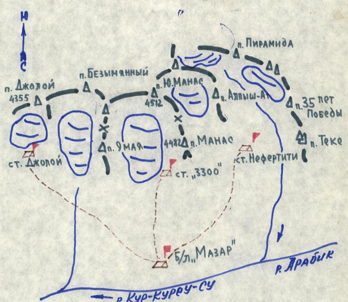
Legend
- Ridges, crests
- Peaks, passes
- Glaciers
- Base and assault camps
- Paths to camps
- Rivers and streams
Location of Manas and Joloĭ Peaks
"Nefertiti" Camp (2866 m)
The "Nefertiti" camp is located at an altitude of 2866 m above sea level, on the right bank of the Terek River (orographically). From the "Mazār" base camp:
- Ascend upstream along the gorge to the confluence of Arabik and Terek rivers (30–40 minutes).
- Then follow the Terek River along its right bank (orographically) (see diagram) for 2–2.5 hours to the assault camp. The assault camp is located at the foot of Peak Teke (two large 12–15 m high rocks serve as a landmark). This location offers views of the peaks:
- Teke
- Pyramida (Tervk)
- Korona (Alpysh-At)
- Manas
- others. The camp is convenient due to its proximity to the main routes, availability of water, and firewood throughout the season. The journey from the "Mazār" base camp to "Nefertiti" camp takes 3–3.5 hours.
"Joloĭ" Camp (3560 m)
The "Joloĭ" camp (3560 m) is located on a moraine under the northern wall of Joloĭ Peak. It is advisable to leave the "Mazār" base camp in the morning. Then:
- head in a northeasterly direction for 2–2.5 km to a stream flowing from under the Joloĭ glacier;
- ascend along the stream for 1 hour to a broad canyon of the main river flowing from the Joloĭ glacier;
- continue ascending a fairly steep talus slope (small and medium talus) for 40–60 minutes to the camp, orienting towards the center of the northern wall of the peak. The camp is situated on a convenient platform 30 minutes from the base of the wall, protected by large boulders. The camp offers a good view of all possible routes up the wall. The entire journey from the "Mazār" base camp to "Joloĭ" camp (3560 m) takes 3.5–4 hours.
Peak Alpysh-At (3860 m)
via the Southeast Ridge to the IV tower — Category 2B (from the cirque between Peak Yu. Manas and Peak Alpysh-At)
From the "Nefertiti" bivouac (2866 m) to Peak Alpysh-At (Korona) — 1 hour. Then ascend a broad snowy couloir to a rocky gate to the left of the aforementioned peak — 30–40 minutes. The path continues across the cirque of the Korona glacier, which is snow-covered depending on the time of year — 1.5–2 hours walking. Directly ahead is a beautiful unnamed peak; a route can be laid from the ridge connecting the two peaks. The route is rated Category 2B–3A. We leave behind:
- the talus slopes of Peak Yu. Manas,
- to the right — the rocky walls of I, II, and III towers of Peak Alpysh-At. Looking at the entire ridge of this peak, the leftmost (closer to the unnamed beautiful peak) position is occupied by the IV tower of Peak Alpysh-At, height 3860 m. We approach a fairly steep (40–45°) rocky slope. The ascent is about 400 m. A distinctive sharp rocky "finger" remains to the left. The exit is onto the Southeast Ridge. The start of the route is to the right along the ridge. The ridge includes short rocky sections up to 5–7 m high, with simultaneous belay. Movement along the ridge is facilitated by laying rope around outcrops, over a distance of about 150 m.
- I gendarme: traverse to the left along easy Category II rocks.
- Ahead is the II gendarme: we pass a rocky "konëk" (ridge) about 13–15 m long, with steep rocky walls dropping down to the right.
- We approach the base of the gendarme from the right (along the route) using small inclined ledges; the gendarme is about 25–30 m high.
- Movement is always on the "konëk" and during the overcoming of the gendarme — with alternate belay (including Category III elements).
- Then there is a 12 m shoulder, from which a traverse of snowy ledges begins, followed by a 30 m ascent to the ridge — Category II–III.
- Next is a lowering in the ridge to a 25–30 m col.
- The rocky ridge is bypassed on the left along simpler sections, about 100 m.
- After that, an ascent begins along easy rocks to the summit of the IV tower of Peak Alpysh-At.
The descent into the Korona glacier cirque is via snowy and talus slopes from the middle part of the route. The descent path is clearly visible. Then the descent continues along the moraine to the "Nefertiti" camp. The ascent from camp to camp takes 8–9 hours. As an alternative, one can descend towards Peak Pyramida to the south, along talus (or snowy) slopes to the Terek River, and then down to the "Nefertiti" camp. The difficulty of the descent is not more than Category 1.
The first ascent was made on May 3, 1980, by a group from the USSR Sports Committee, consisting of:
- Mukanov K.B.
- Oreshko V.V.
- Tashmanbetov Kh.S.
- Prokop'ev V.V.
Recommendations for Climbers
- Number of participants — 6 people.
- Initial bivouac — "Nefertiti" camp (2866 m).
- Departure from the bivouac no later than 6:00.
Equipment for the Group
- Main rope — 3 × 30/40 m.
- Rock pitons (various) — 5–6 pieces.
- "Dedovskie" pitons — 2–3 pieces.
- Rock hammers — 2 pieces.
Apparatus — Ar, etc.
Appendix No. 2. Nature of the Route. Pitons.
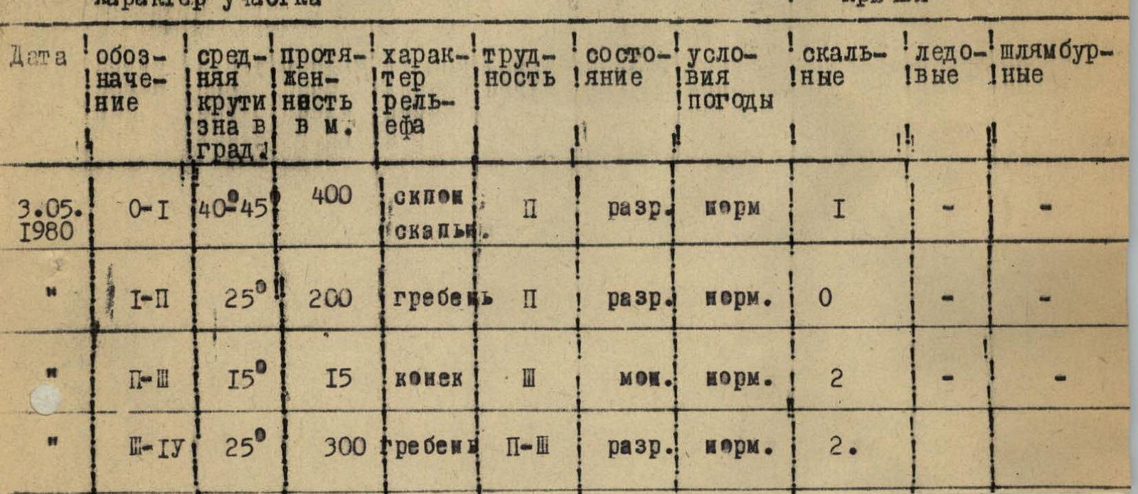
| Date | Designation | Average steepness in degrees | Length in m | Nature of terrain | Difficulty | Condition | Weather conditions | Rock pitons | Ice pitons | Bolt pitons |
|---|---|---|---|---|---|---|---|---|---|---|
| May 3, 1980 | O–I | 40–45° | 400 | rocky slope | II | loose | normal | 1 | ||
| I–II | 25° | 200 | ridge | II | loose | normal | 0 | |||
| II–III | 15° | 15 | "konëk" | III | wet | normal | 2 | |||
| III–IV | 25° | 300 | ridge | II–III | loose | normal | 2 |