Ascent Passport for
Mt. Okhotnichya (3099) (according to the 1989 classifier) Mt. Okhotnichy (3099) (according to the 2011 classifier)
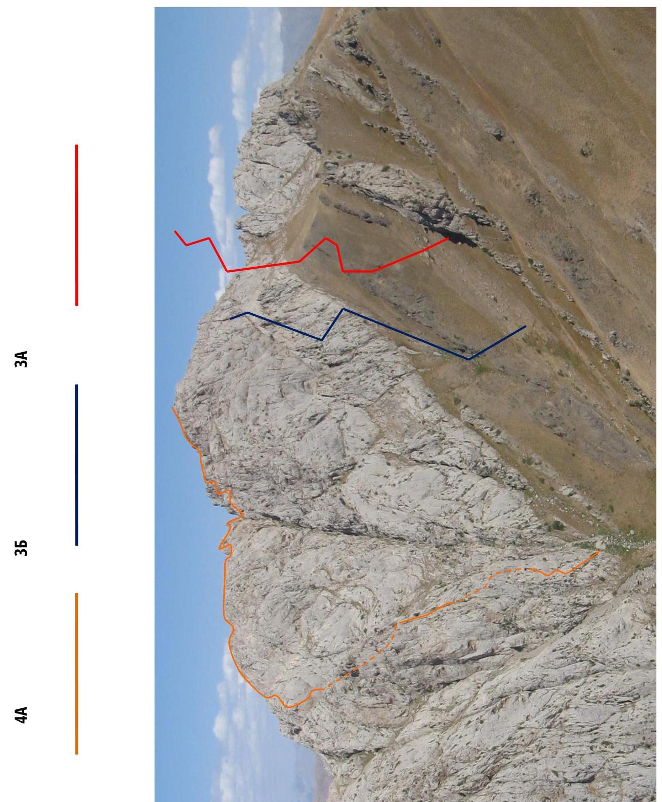
Left part of the Western wall
October 9, 2011
Sheet 1, page 1.
Ascent Passport
- Western Tian-Shan, Chatkal Ridge, Mazarsay river gorge №7,12 according to the 2011 classification table.
- Peak Okhotnichya 3099 m. Left part of the Western wall. First ascent. Coordinates of the peak: 41303765 C; 70665860 C
- Proposed — Category III complexity.
- Character of the route: rock.
- Height difference of the route: 400 m
Route length: 590 m. Average steepness of the entire route: 55°. Main part of the route: 65°;
- Number of pitons left on the route — none.
- Team's walking hours: route passage 5 hours, 1 day.
- Leader: Alisher Fuzailov, II+ sports category.
Participants:
- last name, first name, sports category:
Alexey Sadykov — II sports category; Alexander Chertanov — II sports category; Umid Salamullaev — II+ sports category.
- Coach: Nina Shashlova (Zhutova), CMS I category, №4593 (STR title)
- Exit to the route from the base camp: 8:00, October 9, 2011. Route started: "8:00", "9", "October", "2011". Summit reached: 13:00, October 9, 2011. Return to BC: 17:00, October 9, 2011. Descent via Tumanный pass to Mazarsay gorge.
- Organization: Republic of Uzbekistan, Tashkent. IRBIS Climbing Club.
- Person responsible for the report: Umid Salamullaev. Email: chimgan3309@gmail.com
Sheet 1, page 2.
Photograph taken from the North ridge of Mt. Big Chimgan.
Sheet 2, page 4.
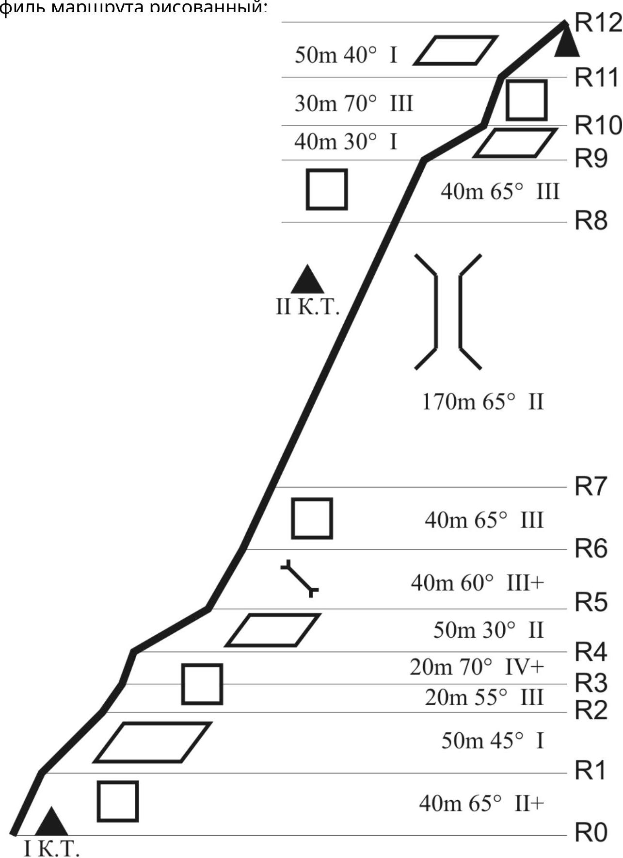
It is not possible to provide a photo of the route profile, as the route is closed by the terrain on both sides.
Profile of the route:
 Sheet
3, page 5a.
Sheet
3, page 5a.
Approach to the route:
From the 82nd km of the Tashkent — Brichmulla road, ascend to the "Pesochny" pass. Descend along the trail to the Gulkamsay gorges (do not enter the gorges!). Ascend 150–200 m along the left tributary, cross the say, and ascend along the trail (red scree slope, the trail is poorly visible in the lower part).
Reach the ridge crest, ascend to the right. The trail then flattens out and reaches the crest, the eastern slope of which descends into Kuyliksay. Continue to the right along the wide trail to the upper reaches of Kuyliksay (do not descend to the lower trail!).
Then, along a steep, light-colored scree trail, ascend to the Northeast ridge, and continue to the right along its Eastern slope on the most noticeable wide trail. The Northeast ridge separates the Kuyliksay and Mazarsay gorges. The trail runs 300–400 m above the Mazarsay river and, bypassing the counterfors of the ridge, reaches the last counterfor. Here is a grotto with a characteristic "window".
From the grotto, descend to the left along the trail towards the say. Cross the say and ascend along the trail. Then, follow the clearly visible trail towards Mt. Okhotnichya.
The approach takes 7–8 hours from the 82nd km of the Tashkent — Brichmulla road. Sheet 3, page 6.
| Section № | Length (m) | Steepness, degrees | Terrain character | Difficulty category | Number of pitons |
|---|---|---|---|---|---|
| Ro | Start of the route. 1st control point | ||||
| R0–R1 | 40 | 65 | Vertical wall | II+ | |
| R1–R2 | 50 | 45 | Terrace, movement to its left part | I | |
| R2–R3 | 20 | 55 | Wall of medium difficulty. Movement up and right. | III | 4 |
| R3–R4 | 20 | 70 | Wall, difficult climbing. Movement up and right. | IV+ | 6 |
| R4–R5 | 60 | 30 | Terrace. Traverse to its right part. | II | |
| R5–R6 | 40 | 60 | Inner corner of medium difficulty. (live rocks at the exit) | III+ | 7 |
| R6–R7 | 40 | 65 | Steep blocks form a wall. Movement up and right. | III | 5 |
| R7–R8 | 170 | 60 | Steep couloir with "live" rocks. Movement up and right. At the exit from the couloir, a second control point on the right. | II | 13 |
| R8–R9 | 40 | 65 | Wall of medium difficulty. Movement straight up. | III | 6 |
| R9–R10 | 40 | 30 | Terrace. Movement up and right. | I | |
| R10–R11 | 30 | 70 | Wall of medium difficulty. Movement up and left. | III | 4 |
| R11–R12 | 50 | 40 | Pre-summit ridge. Simultaneous movement. | ||
| R12 | Summit. |
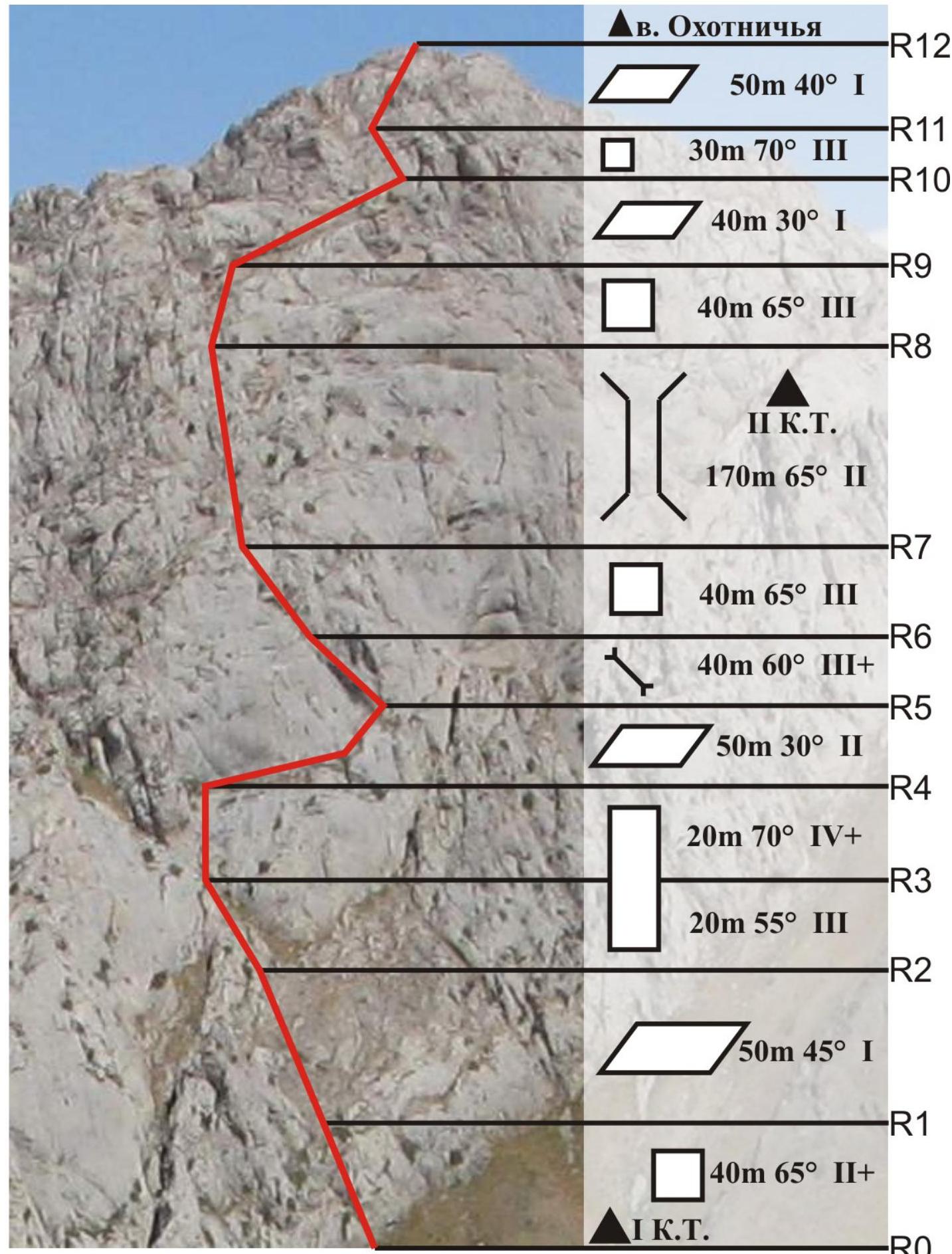
Sheet 4, page 7. Technical photograph of the route:
Sheet 4, page 8.
Route description:
R0–R1 — vertical wall, piton belay, chocks. First control point under the wall ( landmark — juniper).
R1–R2 — grassy terrace, movement to its left part.
R2–R3 — wall of medium difficulty. Movement up and right. Belay: pitons, chocks.
R3–R4 — wall, difficult climbing. Movement up and right. Belay: pitons, chocks.
R4–R5 — terrace. Traverse from left to right.
R5–R6 — inner corner, piton belay, chocks. Live rocks at the exit!
R6–R7 — steep blocks form a wall. Movement up and right. Piton belay.
R7–R8 — movement along a steep couloir, "live" rocks! Exit up and right. Before exiting the couloir, a second control point on a small terrace at the base of the wall on the right. Landmark: white circle on the left wall of the couloir.
R8–R9 — wall of medium difficulty, move straight up. Piton belay, chocks.
R9–R10 — terrace. Movement up and right.
R10–R11 — wall of medium difficulty. Move up and left. Piton belay, chocks.
R11–R12 — pre-summit ridge. Simultaneous movement.
R12 — summit.
Descent to Tumanный pass, then along the approach path to Gulkamsay gorges, to Pesochny pass.
Sheet 5, page 9.
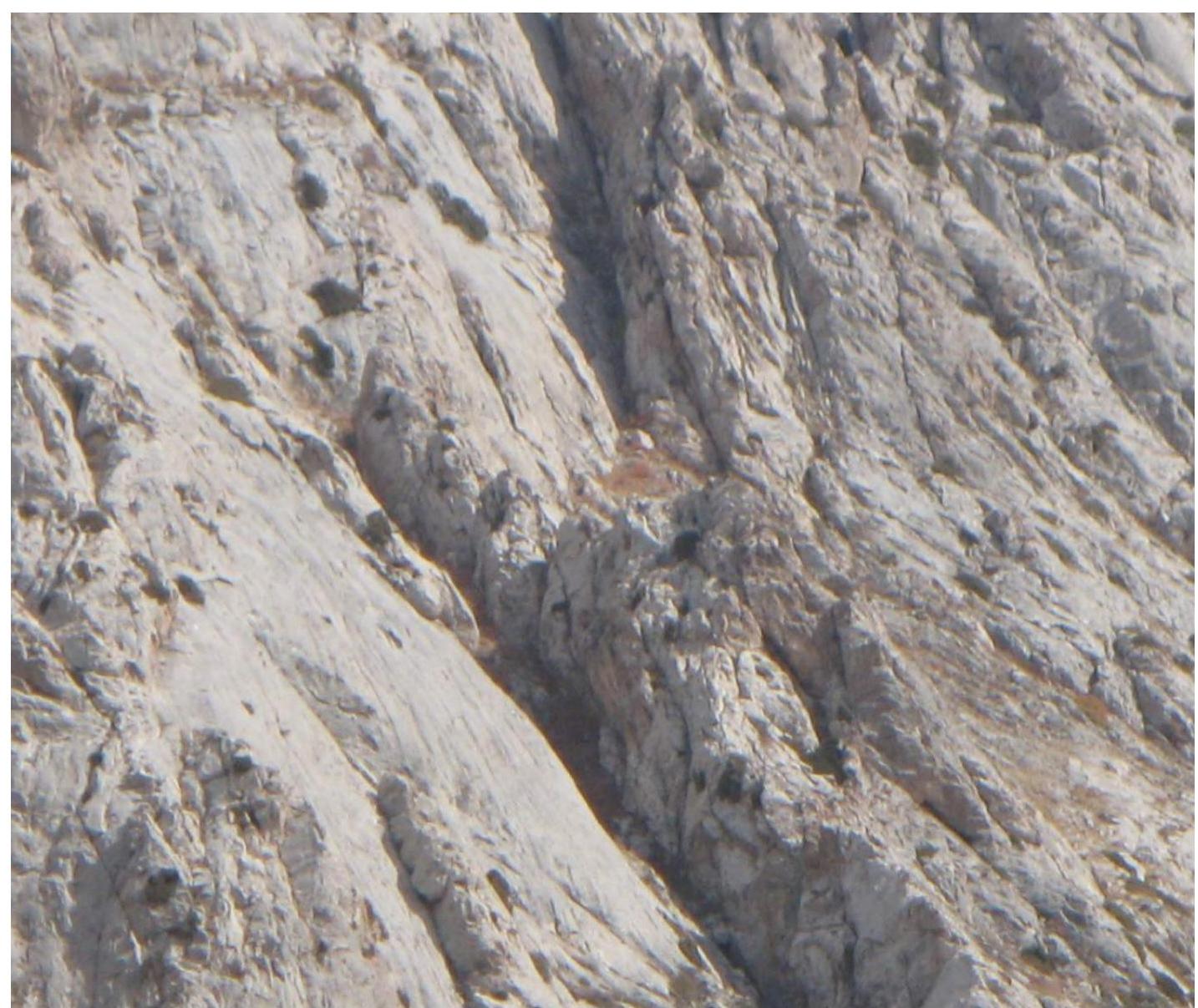
Photographic illustration of the report. The photograph shows:
- section R1–R2 (terrace),
- R3–R4 — key section (difficult climbing) with exit to the terrace.
Section R2–R3 is closed by the terrain and not visible.