ASCENT CERTIFICATE №1
Class: ROCK Region: TIEN-SHAN, Ugam ridge (7.II) Peak: SOLIDARNOST Height: 3600 m (according to KTMGV-89) Route and proposed complexity category: via south-west slope 41. Solidarnost 3600 1B cat. diff. (via 3rd slope V. Shadrin, 1998) 1B cat. diff.
Height difference: 400 m Length: 700 m Steepness: avg. 40° (max – 65°) Protection: 4 pitons driven + ledges Climbing hours: to the summit — 4 (from bivouac "2300" — 6)
Leader: Shadrin Viktor Aleksandrovich (CMS) Participants: Agafonov Anat. Kondr. (P), Agafonov Al-dr Isak. (–), Kukushkin Oleg Ivan. (P), Muslimov Enver I. (–), Sedanova Nat. Vas. (–), Khudayberdin Airat S. (–) Deputy leader: Yusev Anton Yur. (P) Date: April 30, 1998
ASCENT CERTIFICATE №2
Class: ROCK Region: TIEN-SHAN, Ugam ridge (7.II) Peak: CHIMKENT Height: 4000 m (according to group's altimeter) Route and proposed complexity category: from south to western ridge Chimkent 4000 2A cat. diff. (via S to W ridge V. Shadrin, 98) 2A comb.
Height difference: 680 m Length: 1050 m, including the summit tower — 120 m Steepness: avg. 40° (max – 65°) Protection: 8 pitons + 3 placements (no old pitons) Climbing hours: to the summit — 5.6 (from bivouac "2300" — 8.2)
Leader: Instructor Shadrin Viktor Aleksandrovich (CMS) Participants: Agafonov Al-dr Isak. (–), Kukushkin Oleg Ivan. (P), Muslimov Enver I. (–), Sedanova Nat. Vas. (–), Khudayberdin Airat S. (–) Date: May 5, 1998
NOTE. V. Shadrin's group was released for the second ascent and found a note from A. Romanov + V. Bobrovsky, A. Kozlov's group on the axial line of the Ugam ridge, about 40 m from the highest point of p. Chimkent, and on the summit — a note from UPI-97 group (S. Askarov + Z). The first ascent was NOT CREDITED to A. Romanov's group.
Senior coach: Lyovin Mikh. Semen. (MS, 1st sports category).
SOLIDARNOST via south-west slope 1B cat. diff. From the motorway near Kasaksu settlement, and from the bridge over the Sazanata river near the camping site, the Solidarnost massif appears to be dominant in the Sayram-su gorge.
The first ascender Sh. Rafikov (Chimkent) in 1985 ascended via one of the northern buttresses of the western edge (4B). Two years later, both "profiles" were climbed:
- 4A
- 3B (three more routes not lower than the category are suggested).
There have been unpleasant cases when groups, searching for an easy descent, lost their bearings and a lot of time, cut ropes, etc. Therefore, we will describe the most convenient "DESCENT PATH" for any time of the year to be included in the KTMGV.
Technical description
From the fork "1860" upstream along the trail along the Sayram-su river with a transition to the northern slopes of Altus and a gain in height along the trails in the direction of the Solidarnost massif.
Having descended under the western slopes of the massif (bivouac is possible at the so-called "Green hill" after the confluence "2300"), bypass the buttresses to the right:
- first along the riverbed,
- then along the scree and snowfields of the cirque.
Leaving behind the southern edge (3B), and then three parallel ridges — the "Lap", turn left — up.
ALTERNATIVE: gain another 100–120 m in height along the BZ slope and go left in traverse along the middle scree through the ridges of rocks.
LANDMARK: the junction of the wall of the eastern ridge of Solidarnost with the wall of the long buttress, forming the "Lap" below.
Before the junction of the walls, the BZ slope becomes steeper. In roped teams, exit via the internal corner to the beginning of an inclined shelf 80 m, allowing to cross the steep wall of the buttress. The width of the shelf is 0.4–2 m, there is ice in spring.
After exiting onto the ridges of the buttress, a pre-summit saddle is visible above. Where the shelf leads, we built a large cairn so that those descending do not miss the turn onto the shelf — the key to the descent.
The scree "spade" surrounded by rocks on three sides leads to the saddle of the ridge, leading to p. Chimkent. 15 m above the saddle — the summit cairn. Descent, naturally, via the ascent route.
PHOTO №3: view of the described route from the summit of Arsen (August 1997).
Route 1B cat. diff. is shown with a dotted line.
Arrow A indicates the direction to the "So-Chi" (Solidarnost — Chimkent) saddle when ascending to p. Chimkent via route 2A cat. diff. ("Certificate №2").
The junction of the walls is not visible in the photo, but the inclined shelf and the profile of the top of the 3B cat. diff. edge are clearly visible.
In the background:
- NW ridge of Sayram peak,
- behind it — the wide valley of the Sazanata river.
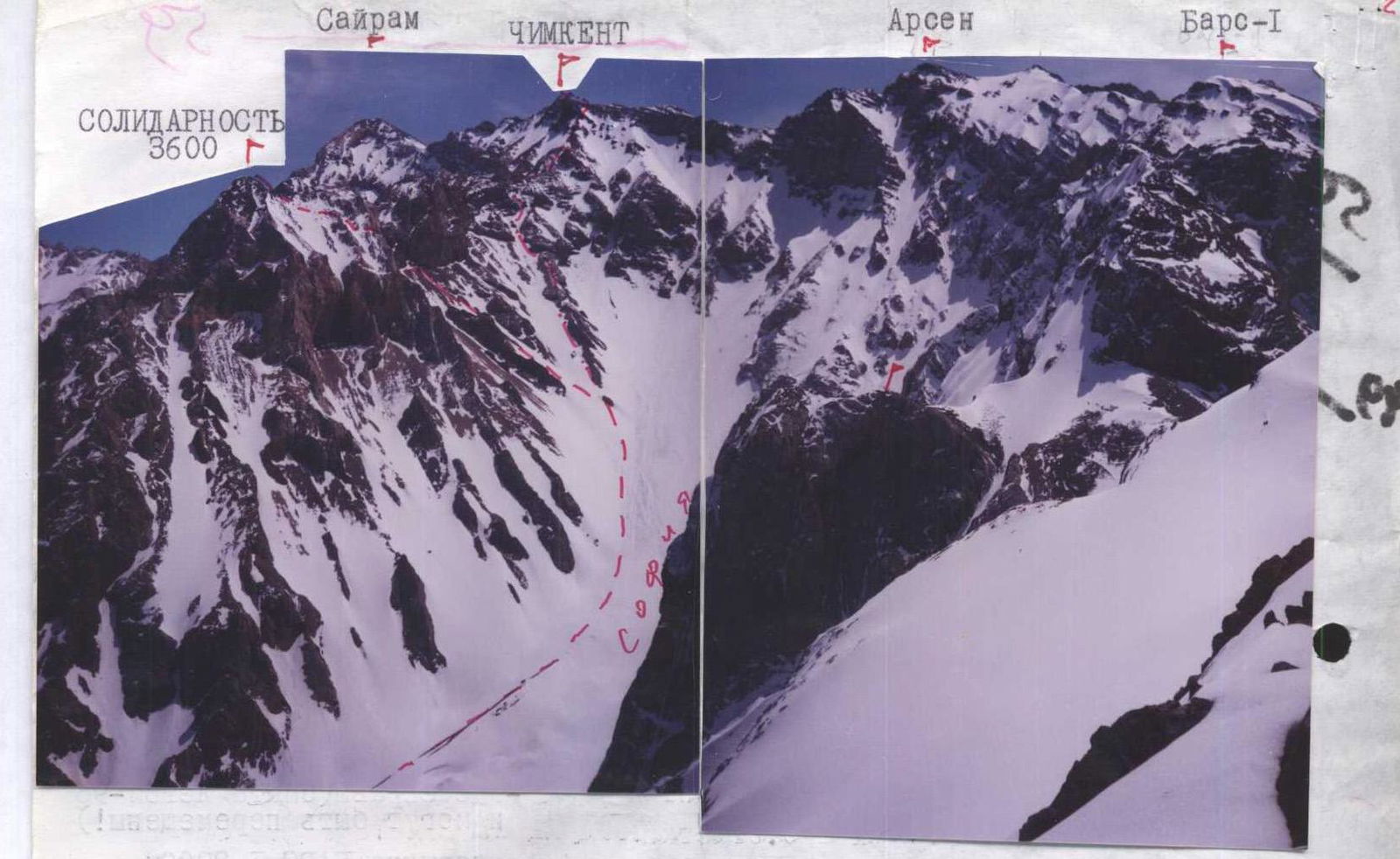
PHOTO №1: View from p. Altus to the east (April 1998). The eastern ridge of p. SOLIDARNOST overlaps with the western slope of Sayram and the Sayram — Chimkent ridge.
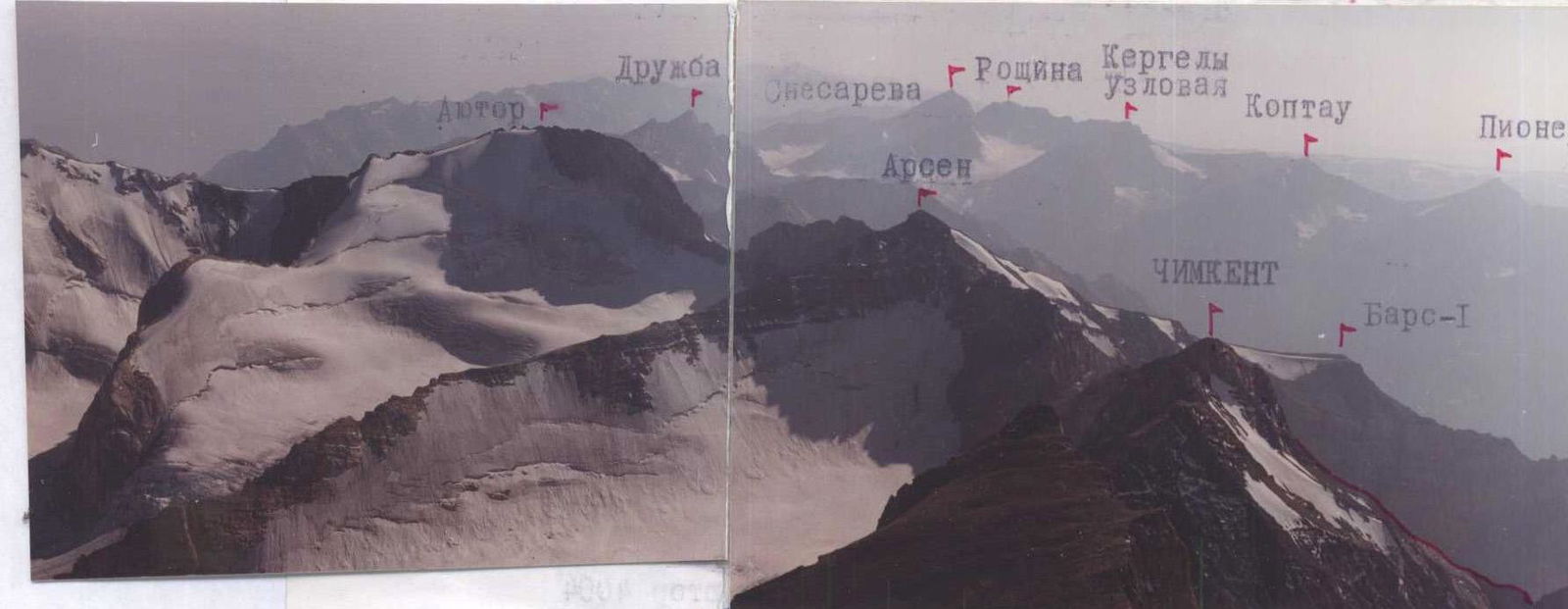
PHOTO №2: View from p. Sayram to the south and southwest (August 1997). Glaciation is more extensive on the Uzbek side.