Ascent Passport
- Tian-Shan, Ugam ridge, Sayram-Su gorge, 7.11
- Peak name: Kyzylbash, route: via the left part of the NE wall
- Route category 6A difficulty level according to KMGV 1999 >3×205
- Route type: rock
- Route elevation gain: 755 m Route length: 835 m Section lengths: R1 — 228 m, R2 — 217 m Average steepness: — main part of the route — 82°, — entire route — 72°
- Pitons driven on the route: total — 244; including bolted: 12. Pitons used on the route: stationary bolted: 31, including for artificial climbing — 16 removable bolted — Including for artificial climbing — Total artificial climbing points (ACP) used: 55.
- Team's travel hours: 36 h. 4 days (including 20 h of route development).
- Leader: Paveliev Anatoliy Vasilievich, CMS Participants: — Pavelieva Nelya Abbasovna, CMS — Kartsev Sergey Mikhailovich, 1st sports category — Koltakov Nikolai Nikolaevich, 1st sports category — Popova Rimma Valentinovna, 1st sports category — Rafikova Natalia Vladimirovna, CMS
- Coach: Paveliev Anatoliy Vasilievich
- Departure to the route: 10:00 August 19, 2000
Summit reached: 16:00 August 22, 2000
Return: 20:30 August 22, 2000
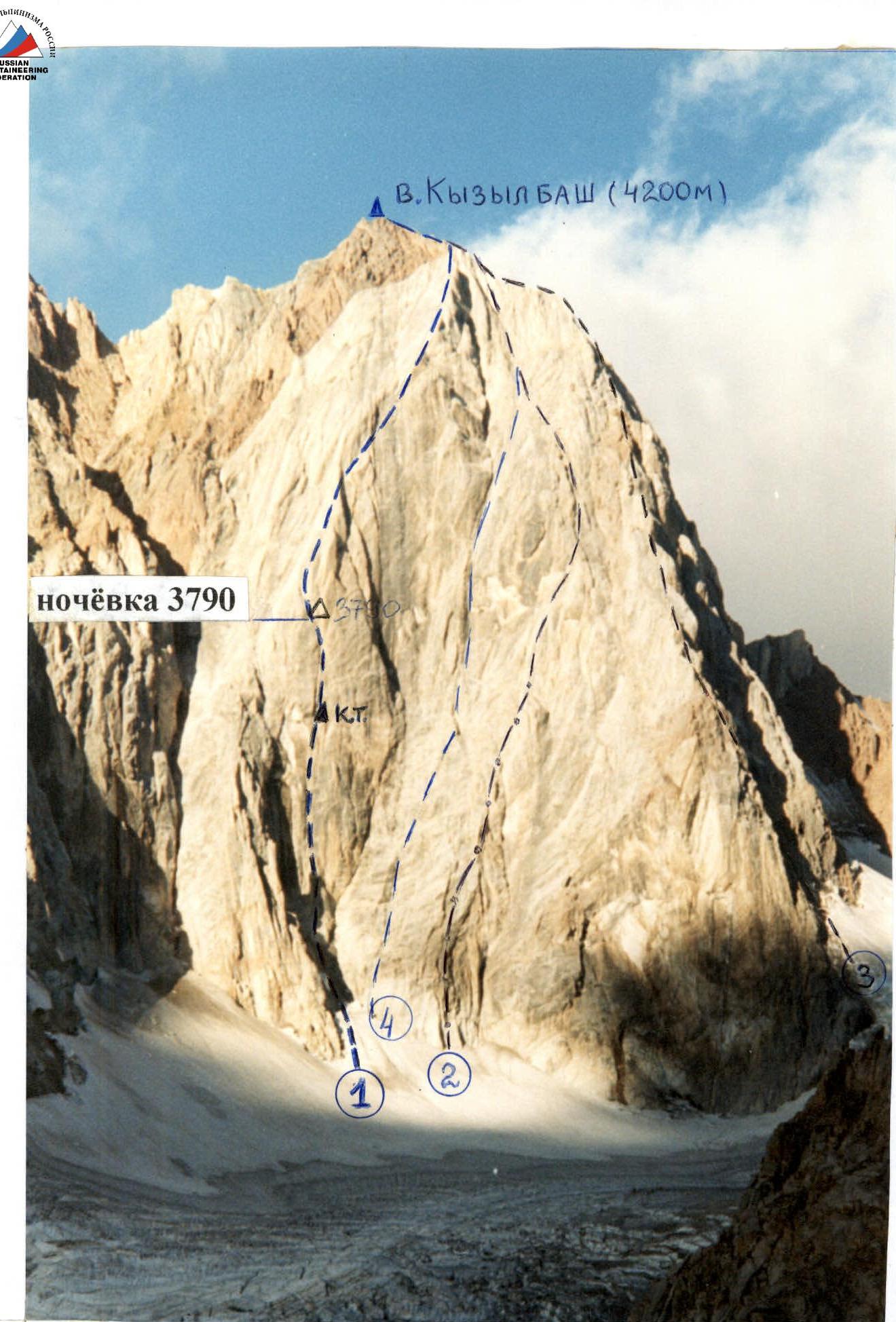
General photo of the peak Kyzylbash (4200) taken on August 18, 2000 at 10:00. Distance 2 km. 1 — 2000 team route, 6A category via the left part of the NE wall (Sh. Rafikov, 1986) 2 — route 5B category via the NE wall (A. Timofeev, 1986) 3 — route 5A category via the N ridge (V. Dediй, 1986) 4 — route 5B category via the center of the NE wall (F. P'yachek, 1988)
List of routes:
— 1 — 2000 team route, 6A category via the left part of the NE wall (Sh. Rafikov, 1986) — 2 — route 5B category via the NE wall (A. Timofeev, 1986) — 3 — route 5A category via the N ridge (V. Dediй, 1986) — 4 — route 5B category via the center of the NE wall (F. P'yachek, 1988)
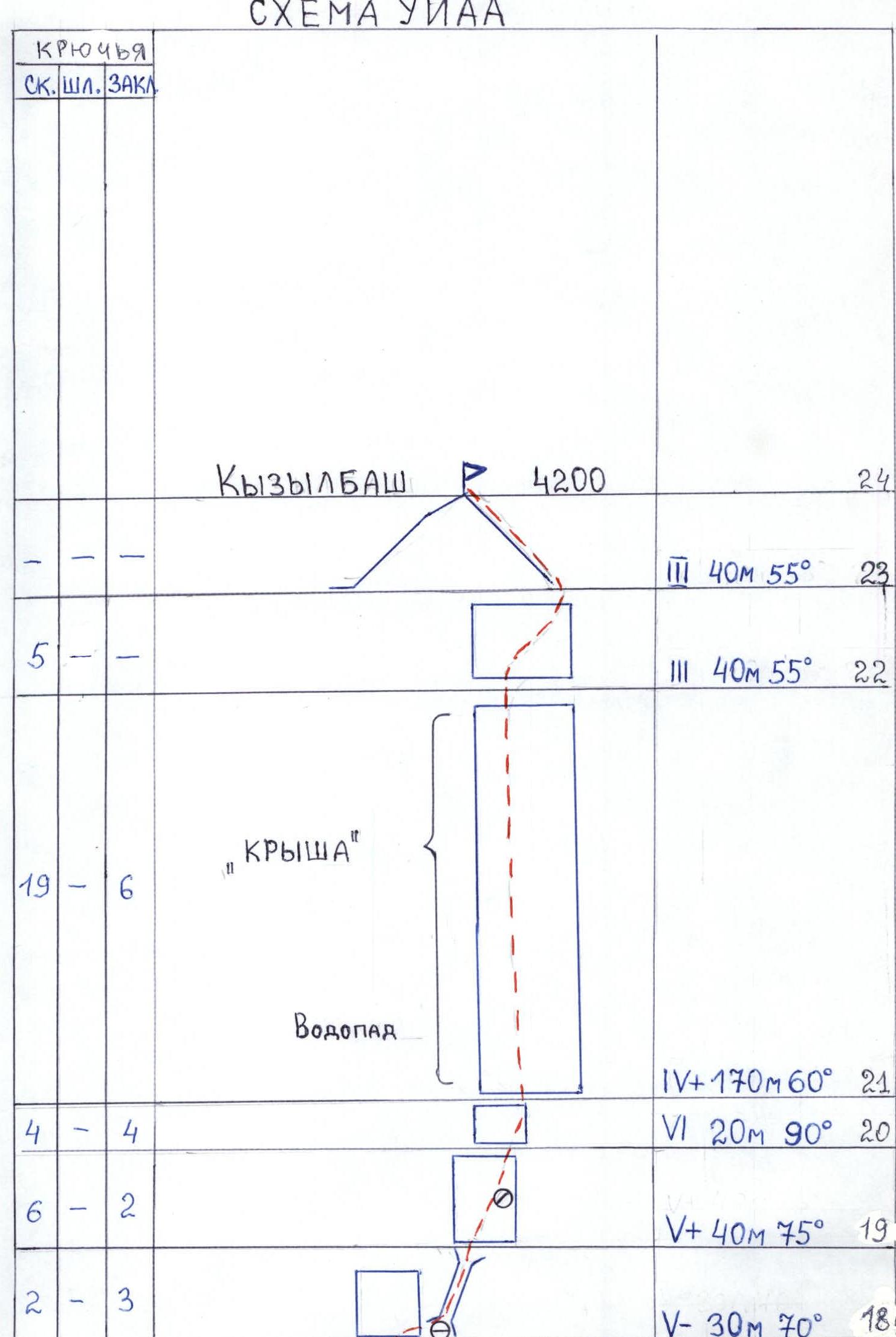
UIAA Scheme
M1:2000
| PITONS | |||||
|---|---|---|---|---|---|
| ROCK | BOLT | ANCHOR | ICE | ||
| 2 | 2 | V+e 10 m 90° 17 | |||
| 2 | 2 | 2 | V+e 30 m 75° 16 | ||
| 5 | 4 | "Rhombus" | V– 70 m 70° 15 | ||
| 3 | 6 | 4 | VI 8 m 85° 14 | ||
| 5 | 4 | 3 | Overnight A | VI 6 m 90° 13 | |
| 1 | 2 | V+ 8 m 75° 12 | |||
| 7 | 5/3 | 8 | VI A2e 20 m 90° 11 | ||
| 2 | 3 | V+e 15 m 75° 10 | |||
| 3/3 | 2/2 | 6/4 | VI A3e 6 m 95° 9 | ||
| 8/4 | 10/5 | Cairn | VI 20 m 90° 8 | ||
| 8/6 | 17/9 | 6/2 | "White Horse" in the form of a Horse | VI A2–A3e 30 m 95° | |
| VI 10 m 95° 7 | |||||
| 8/1 | 4 | VI 20 m 85° 6 | |||
| 12/6 | 1/1 | 7/5 | "Finger" peak | VI A2e 45 m 90° 5 | |
| 3 | 2 | V+ 25 m 85° 4 | |||
| 3 | 1/1 | 2 | VI A2e 12 m 90° 3 | ||
| 4/2 | 1 | VI+A2 10 m 90° 2 | |||
| 2 | 2 | V- 30 m 80° 1 | |||
| 3 | 2 | 4 | IV+ 40 m 60° 0 | ||
| III 80 m 55° 00 | |||||
| Kyzylbash | 4200 24 | ||||
| III 40 m 55° 23 | |||||
| 5 | III 40 m 55° 22 | ||||
| 19 | 6 | "Roof" | IV+ 170 m 60° 21 | ||
| Waterfall | VI 20 m 90° 20 | ||||
| 4 | 4 | V+ 40 m 75° 19 | |||
| 6 | 2 | V- 30 m 70° 18 |
Section Scheme
Route Description by Sections
Section R0–R0 — Steep snow slope 80 m, 55°.
Section R0–R1 — Ice slope cut by a bergschrund. Movement goes around the bergschrund on the left, with an exit to the rocks. Short sections of the ice slope are traversed in crampons.
Section R1–R2 — Rock wall 30 m, 80°. Rocks are fragile. Passed via free climbing. Movement goes from left to right towards an internal corner.
Section R2–R3 — Internal corner 10 m, 90°. Unstable rocks greatly complicate climbing. Exit from the corner straight up — 2 pitons for artificial climbing. To the right, there is a narrow inclined shelf — an inconvenient spot for belaying.
Section R3–R4 — Wall 12 m, 90°. There are practically no holds. Passed using artificial climbing points.
Section R4–R5 — Chimney 25 m, 85°. Climbing is complex, relying on opposition. Leads to a shelf convenient for organizing belays. This is the "Finger" peak. Three people can stand here.
Section R5–R6 — Internal corner 45 m, 90°. Walls are smooth. Vertical cracks are inconvenient for belaying (brittle rocks). In the middle of the internal corner, there is an overhanging section of 2.5–3 m. Passed using artificial climbing points.
Section R6–R7 — Inclined internal corner 20 m, 85°. Climbing is extremely difficult. Walls are smooth. From the internal corner to the left, there is an exit to an inclined shelf sized 0.6 m by 2 m under the "White Horse," suitable for a sitting bivouac.
Section R7–R8 — Internal corner (10 m) transitions into a vertical crack 10 m, 85°, with a width from 15 to 50 mm. Passed via free climbing. "Friends" and stoppers are convenient for belaying. The crack leads under a 30-meter overhanging wall at 95°. The rock is rust-colored, with a scaly structure. The surface layer (crust) breaks off easily, making free climbing impossible. The section is traversed using skyhooks and artificial climbing points. Bolts are used for belaying. Movement is directed towards an internal corner visible from below. The wall ends with an overhang. At the base of the internal corner, there is a small ledge, half the size of the wall, the only spot suitable for organizing a belay.
Section R8–R9 — Internal corner 20 m, 90°. Climbing is extremely difficult. "Friends" and stoppers are used for belaying.
Section R9–R10 — Overhanging crack 6 m, 95°. Passed using artificial climbing points (bolts, eccentric cams, stoppers).
Section R10–R11 — Inclined slab 15 m, 75° without cracks. Passed on friction. Bolts are used for belaying.
Section R11–R12 — Internal corner 20 m, 90°. Walls are smooth. Movement goes up a crack filled with moss using artificial climbing points. Bolts are used for belaying.
Section R12–R13 — Wall 8 m, 75°. Rocks are fragile. Movement is extremely cautious. Exit to a small inclined shelf 30°. Two to three people can stand here.
Section R13–R14 — Steep internal corner 6 m, 90° leads to a second inclined shelf where two people can also stand.
Section R14–R15 — Internal corner 8 m, 85°. Climbing is extremely difficult, relying on opposition. Stoppers are used for belaying.
Section R15–R20 — Upper part of the "Rhombus." Rocks are rust-colored. Heavily destroyed. The structure is similar to section R7–R8. When moving, it is unacceptable to load holds perpendicular to the rock surface (pulling out). There are very few spots to drive pitons, and thus bolts are used for organizing running belays.
Section R20–R21 — Wall with "black streaks" 20 m, 90°. Rocks are wet. Climbing is extremely difficult. Exit to the "Roof."
Section R21–R22 — Gray slabs 170 m, 60°. Movement goes up along water-filled gullies.
Section R22–R23 — Belt of red granite 40 m, 55°. Exit to the ridge.
Section R23–R24 — Ridge 50 m, 35° leads to the summit.
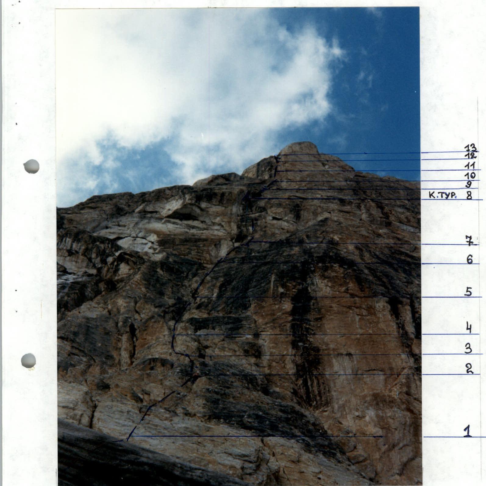
Technical photograph of the main part of the route taken on August 20, 2000 at 12:00 from the start of the route.
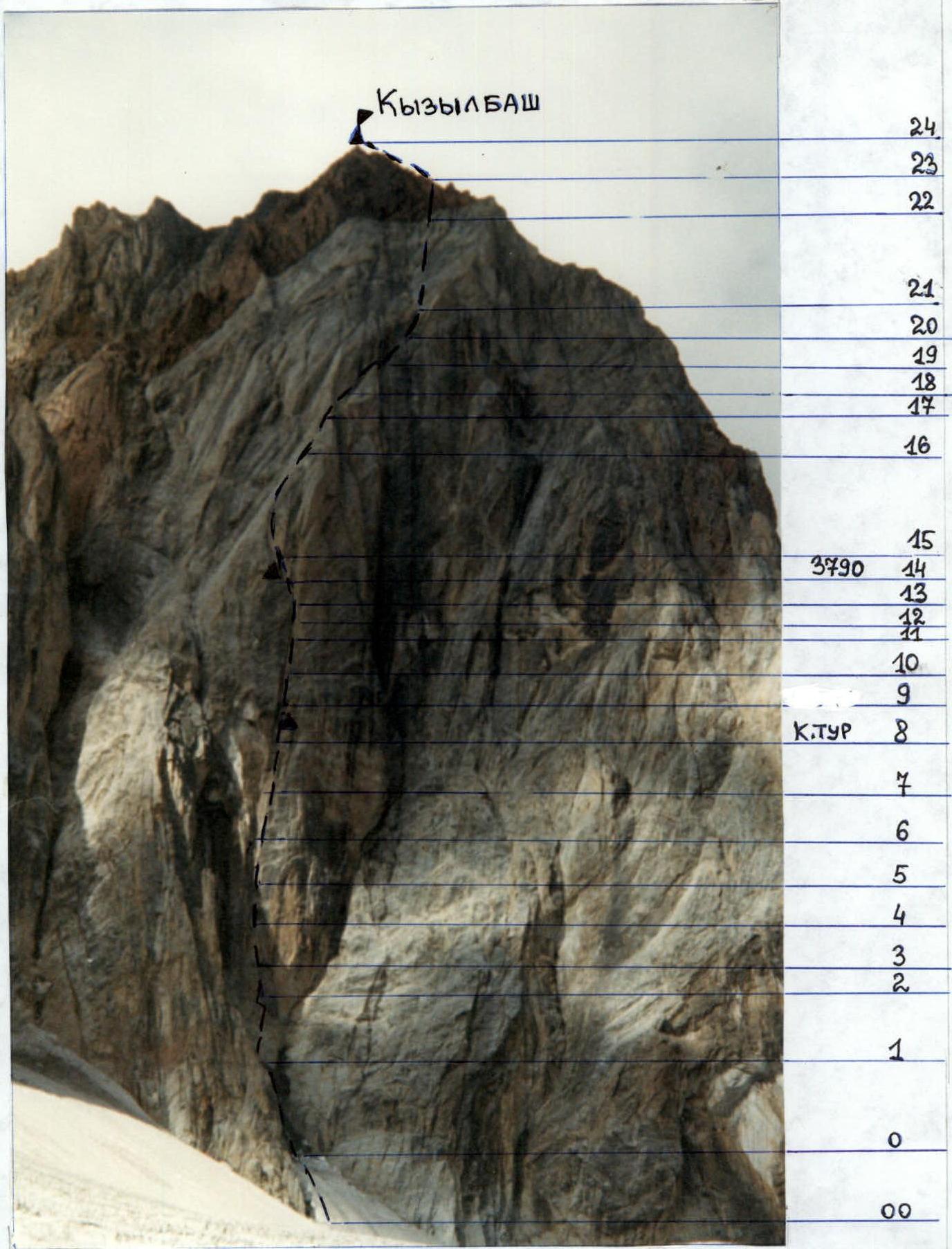
Technical photograph of the route taken on August 18, 2000 at 11:00. Distance 500 m.
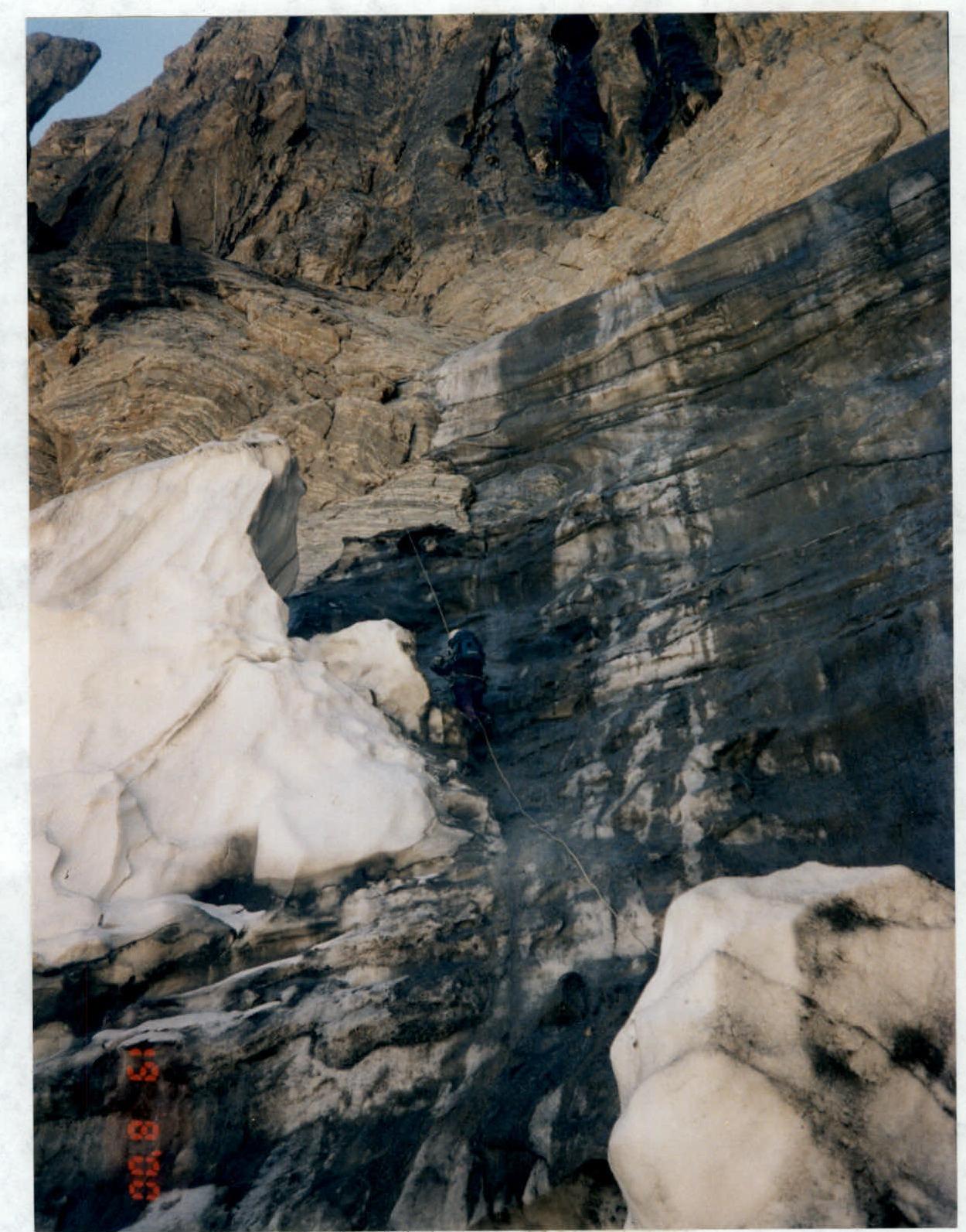
Photo #1. Section R0–R1. Movement along fixed ropes, section with ice.
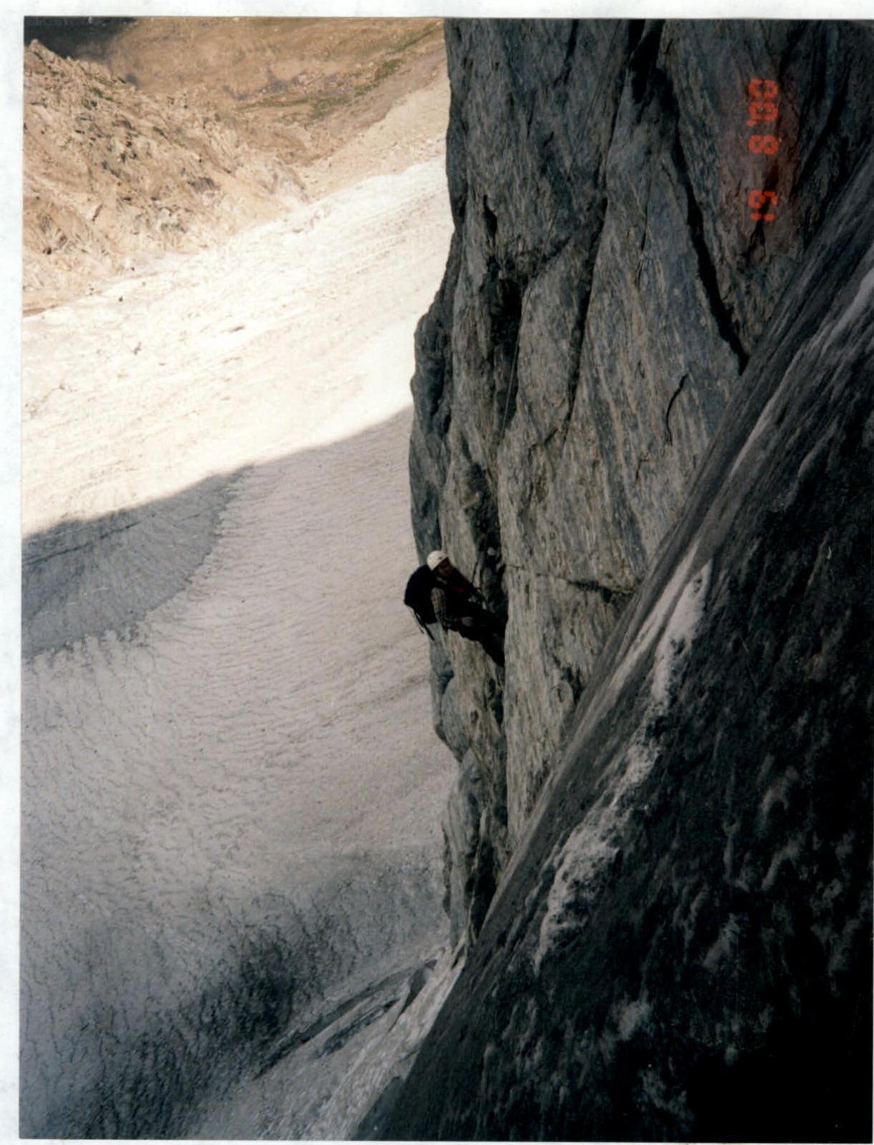
Photo #2. Section R0–R1. Movement along fixed ropes, transition from ice to the rocky part of the route, diagonal ropes.
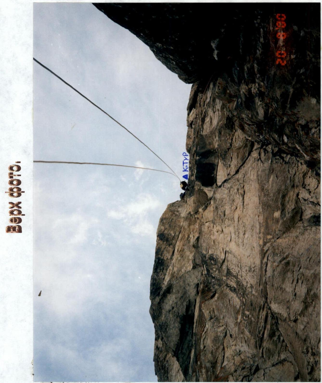
Photo #4. Section R6–R8. Movement along fixed ropes upwards, a participant is bringing up ropes for the lead climber. Above, a control cairn is visible.