Passport
- Rock class
- Western Tian-Shan, Ugam ridge
- Peak 4200 (Kyzylbash), via the left part of the NE wall
- Proposed — 6B category, first ascent
- Height difference: 695 m, length — 755 m, length of sections 5–6 category — 465 m, average steepness of the main part of the route 82° (3540–3990)
- Pitons hammered in:
| Rock | Bolt | Nuts | Ice |
|---|---|---|---|
| 119/22 | 37/13 | 87/16 | 0 |
-
Team's travel hours: 40 hours and days — 4
-
Overnights:
- 1st — two in hammocks, four sitting on ledges of an inclined shelf, hammocks underfoot;
- 2nd — four in hammocks, one sitting on a suspended platform, one sitting on a shelf.
-
Team leader: Rafikov Shamil Rifovich, Master of Sports Participants:
- Dediĭ Viktor Ul’yanovich, Candidate Master of Sports
- Bobrov Aleksandr Mixailovich, Candidate Master of Sports
- Mukanov Kenzhebek Bektoleuovich, Master of Sports
- Savin Aleksandr Borisovich, Candidate Master of Sports
- Uruzgaliev Anatoliĭ Alekseevich, Candidate Master of Sports Coach: Popenko Yuriĭ Stepanovich, International Master of Sports, Honored Coach of the Kazakh SSR
II. Departure to the route: July 1, 1986 Summit: July 4, 1986 Return: July 4, 1986
- Organization: Republican Alpine Club (Kazalpclub)
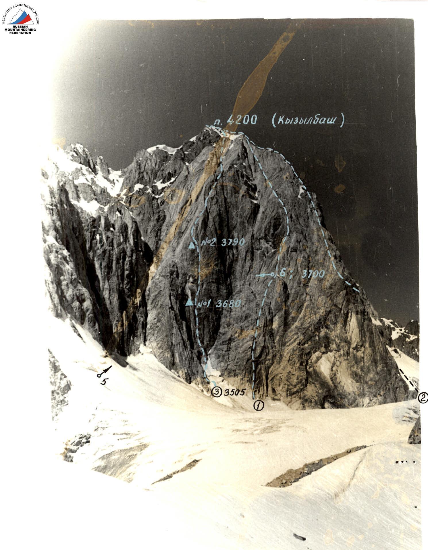
GENERAL PHOTO OF THE PEAK July 1, 1986, 11:00, lens I-50-2, F = 50 mm, distance 2 km, point I, H = 3600 m.
- Route of 1982, 5B category
- Route of 1986, 5B category
- Route
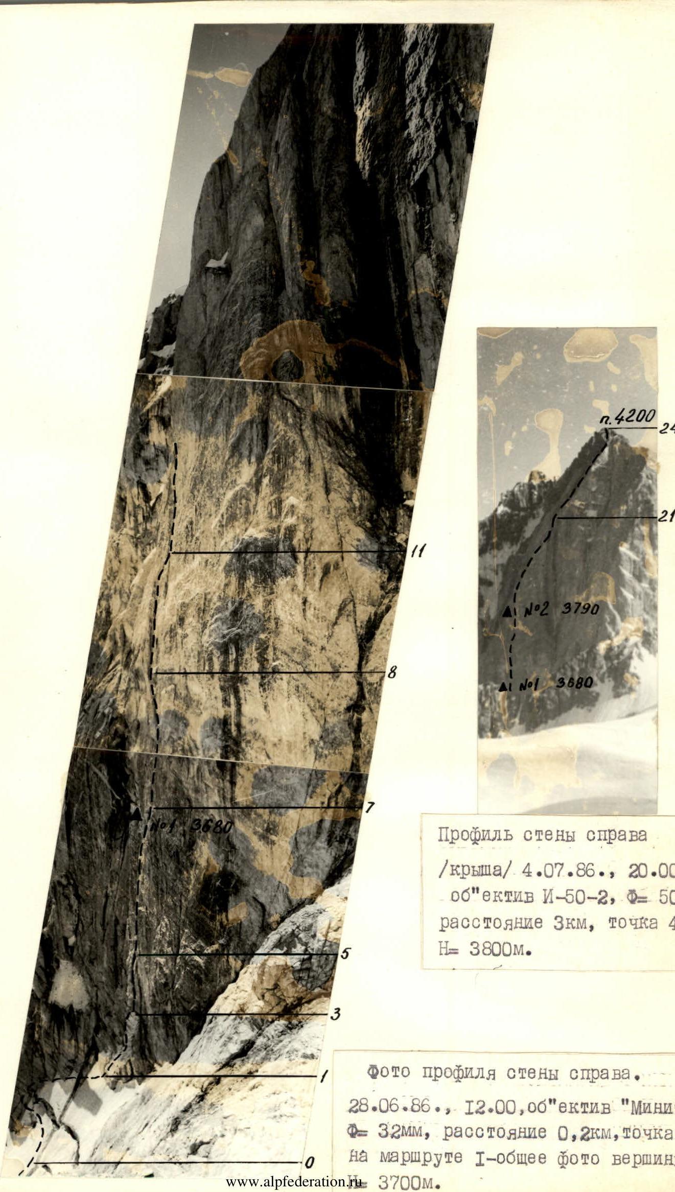
Profile of the wall on the right
"The Roof" July 4, 1986, 20:00, lens I-50-2, F = 50 mm, distance 3 km, point 4, H = 3800 m.
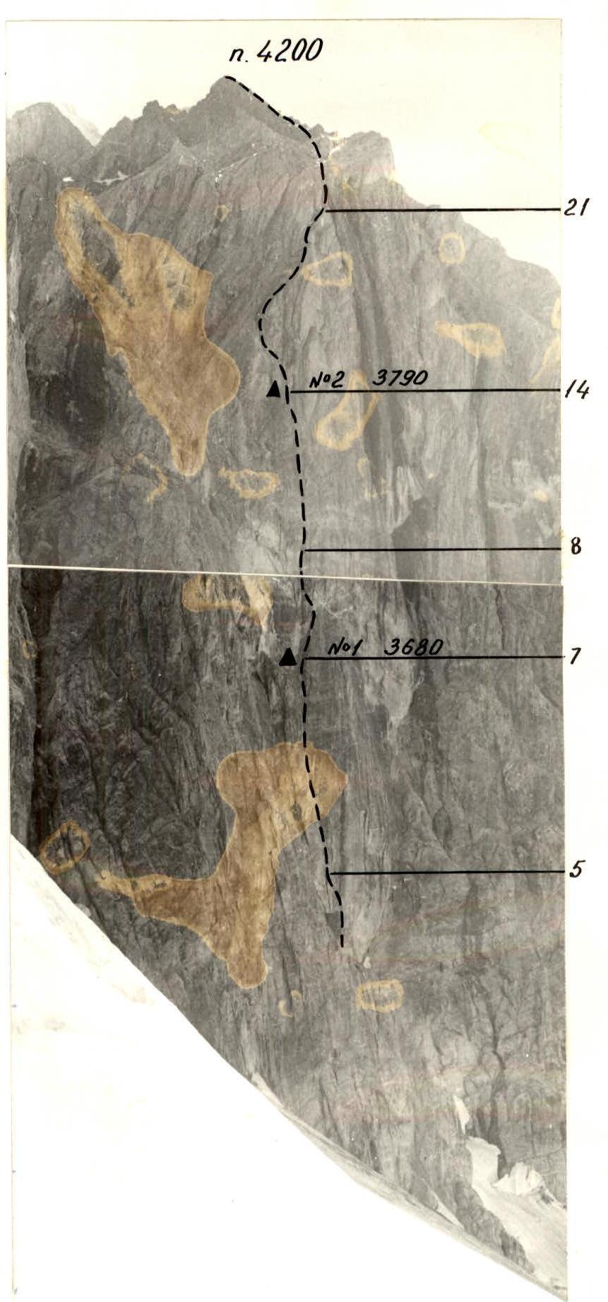
Photo of the wall profile on the right. June 28, 1986, 12:00, lens "Minitar" F = 32 mm, distance 0.2 km, point 6 on route I — general photo of the peak, H = 3700 m.
Photo of the wall profile on the left. June 30, 1986, 14:00, lens I-50-2, F = 50 mm, distance 0.5 km, point 5, H = 3500 m.
Route diagram according to UIAA
Peak Kyzyl-Bash 4200, Route diagram according to UIAA Scale 1:2000
Description of the route by sections
Section R0–R1. Snow-ice slope cut by a bergschrund. Movement bypasses the bergschrund on the left, leading to rocks. Short sections of snow-ice slope are traversed in crampons.
Section R1–R2. Rock wall 30 m, 80°. Rocks are fragile. Passed by free climbing. Movement is from left to right towards an internal corner.
Section R2–R3. Internal corner 10 m, 90°. Unstable rocks greatly complicate climbing. Exit from the corner straight up — 2 pitons for artificial climbing. On the right — a narrow inclined shelf — an uncomfortable place for belaying.
Section R3–R4. Wall 12 m, 90°. Holds are practically absent. Passed using artificial climbing.
Section R4–R5. Chimney 25 m, 85°. Climbing is complex, relying on opposing pressure. Leads to a shelf convenient for organizing belays. This is the summit of the "Finger". Three people can stand.
Section R5–R6. Internal corner 45 m, 90°. Walls are smooth. Vertical cracks are inconvenient for belaying (brittle rocks). In the middle of the internal corner, there is an overhang of 2.5–3 m. Passed using artificial climbing.
Section R6–R7. Inclined internal corner 20 m, 85°. Climbing is extremely difficult. Walls are smooth. From the internal corner, there is an exit to the left onto an inclined shelf sized 0.6×2 m under the "white horse", suitable for organizing a sitting bivouac.
Section R7–R8. Internal corner (10 m) transitions into a vertical crack 10 m, 85°, width from 15 to 50 mm. Passed by free climbing. "Friends" and nuts are convenient for belaying. The crack leads under a 30-meter overhanging wall at 95°. The rock is rust-colored, with a scaly structure. The surface layer (crust) easily breaks off, excluding free climbing. The section is traversed using skyhooks and artificial climbing. For belaying, bolt pitons are used. Movement along the wall is directed towards an internal corner visible from below. The wall ends with an overhang. At the base of the internal corner, there is a small ledge halfway up the wall. The only place suitable for organizing a belay station.
Description of the route (continued)
Section R8–R9. Internal corner 20 m, 90°. Climbing is extremely difficult. For belaying, "friends" and nuts are used.
Section R9–R10. Overhanging crack 6 m, 95°. Passed using artificial climbing (bolt pitons, eccentrics, cams).
Section R10–R11. Inclined slab 15 m, 75° without cracks. Passed on friction. For belaying, bolt pitons are used.
Section R11–R12. Internal corner 20 m, 90°. Walls are smooth. Movement upwards is along a crack filled with moss using artificial climbing. For belaying, bolt pitons are used.
Section R12–R13. Wall 8 m, 75°. Rocks are fragile. Movement is extremely cautious. Exit onto a small inclined shelf 30°. Here, 2–3 people can fit.
Section R13–R14. Steep internal corner 6 m, 90° leads to a second inclined shelf where 2 people can also stand.
Section R14–R15. Internal corner 8 m, 85°. Climbing is extremely difficult, relying on opposing pressure. For belaying, nuts are used.
Section R15–R16, R19–R20. Upper part of the diamond. Rocks are rust-colored. Severely eroded. The structure is similar to section R7–R8. When moving, loading holds perpendicular to the rock surface (pulling out) is not allowed. Places for hammering in pitons are extremely limited; therefore, bolt pitons are used for organizing running belays.
Section R20–R21. Wall with "black streaks" 20 m, 90°. Rocks are wet. Climbing is extremely difficult. Exit onto the "roof".
Section R21–R22. Gray slabs 170 m, 60°. Movement is straight up along gutters with water.
Section R22–R23. Belt of red granite 40 m, 55°. Exit onto the ridge.
Section R23–R24. Ridge 50 m, 35° leads to the summit.