
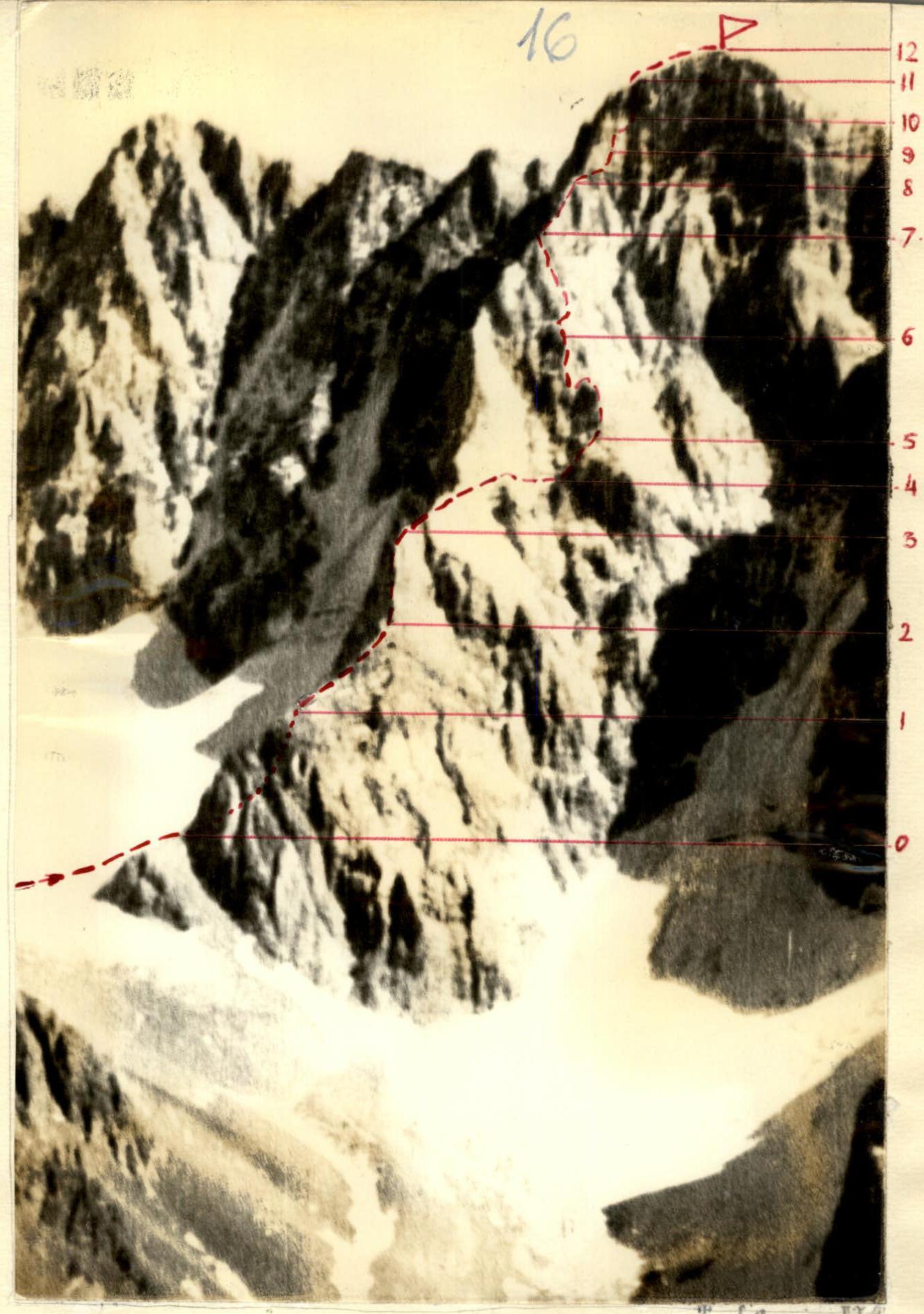
Ascent Route
Druzhba, category 4A via SW ridge (V. Mendorf, 79).
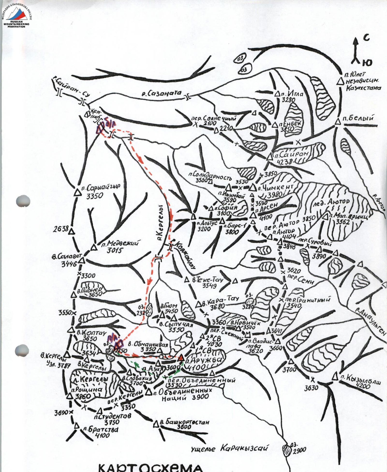
Map
Sairam-su valley, West Tian Shan, Ugam ridge. Scale 1:50,000.
Brief Description of the Approach to the Routes
The "Druzhba" peak is located in the Ugam ridge (Western Tian Shan), southwest of the "Sairam" peak, the highest point in the area. From Chimkent city, follow the asphalt road to the Kaskasu settlement and then continue on a dirt road along the Sairam-su river to the base camp (see the map of the area).
From the base camp, follow a good trail along the Kergely river for 3.5 hours to reach the overnight stay location near the upper lakes.
The approach to the start of the routes takes 1.5 hours walking through a wide couloir to the right of the "Obmanchivaya" peak. Upon reaching the upper moraine near the glacier, the northwest facade of the "Druzhba" peak is clearly visible.
The descent from the summit is via the southwest ridge, and, without reaching the "Obedinenny" pass, follow the path to the right and down to the upper lakes.
Table
Main Characteristics of the First Ascent of the Central Counterfort of the S-3 Wall of "Druzhba" Peak
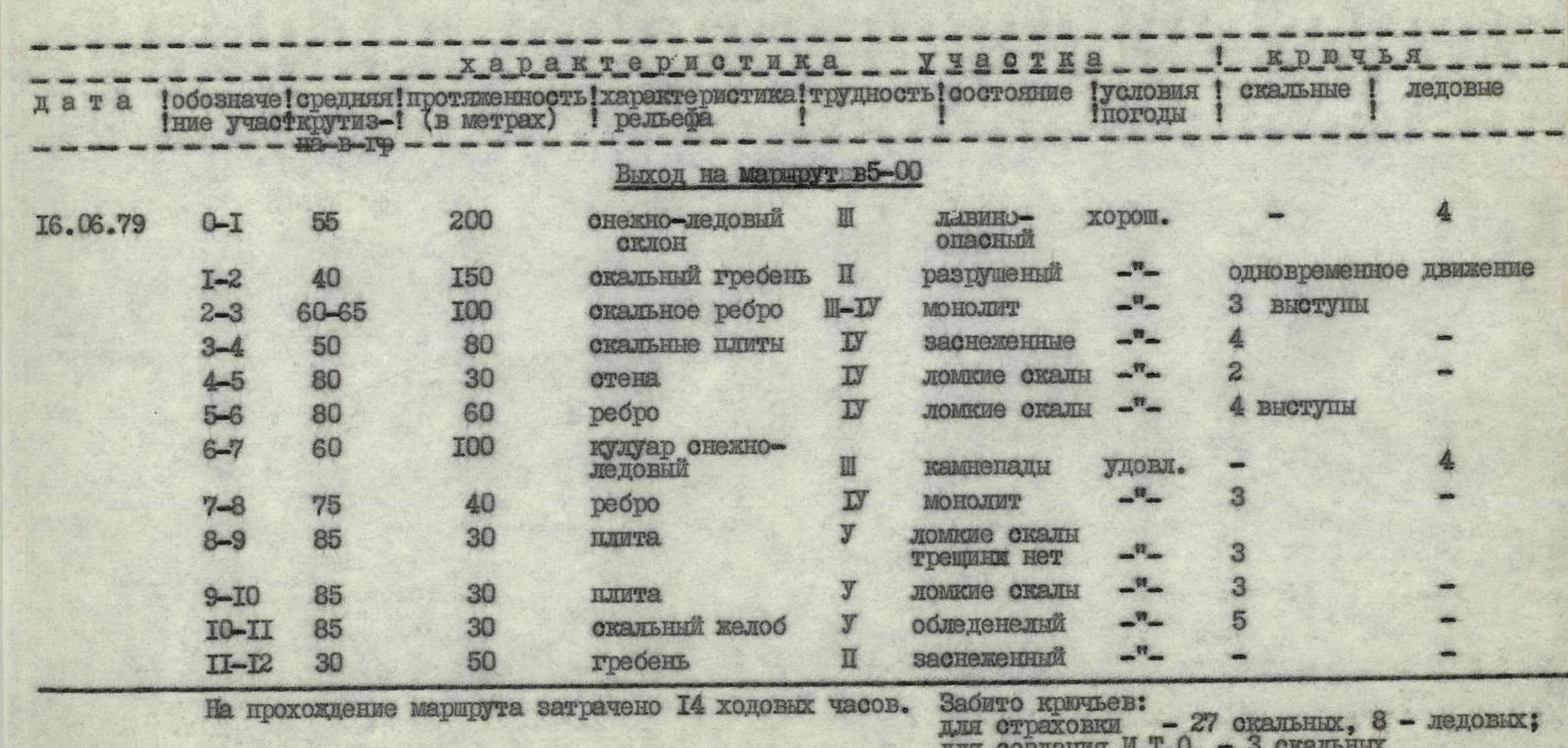
Route start at 5:00.
| Date | Section | Average Steepness (°) | Length (m) | Relief Characteristics | Difficulty | Condition | Weather Conditions | Rock Pitons | Ice Pitons |
|---|---|---|---|---|---|---|---|---|---|
| June 16, 1979 | R0–R1 | 55 | 200 | Snow-ice slope | II | Avalanche-prone | Good | — | 4 |
| R1–R2 | 40 | 150 | Rocky ridge | II | Destroyed | — | Simultaneous movement | — | |
| R2–R3 | 60–65 | 100 | Rocky edge | III–IV | Monolithic | — | 3 protrusions | — | |
| R3–R4 | 50 | 80 | Rocky slabs | V | Snow-covered | — | 4 | — | |
| R4–R5 | 80 | 30 | Wall | V | Brittle rocks | — | 2 | — | |
| R5–R6 | 80 | 60 | Edge | V | Brittle rocks | — | 4 protrusions | — | |
| R6–R7 | 60 | 100 | Snow-ice couloir | IV | Rockfall | Fair | — | 4 | |
| R7–R8 | 75 | 40 | Edge | V | Monolithic | — | 3 | — | |
| R8–R9 | 85 | 30 | Slab | V | Brittle rocks, no cracks | — | 3 | — | |
| R9–R10 | 85 | 30 | Slab | V | Brittle rocks | — | 3 | — | |
| R10–R11 | 85 | 30 | Rocky chute | IV | Icy | — | 5 | — | |
| R11–R12 | 30 | 50 | Ridge | I | Snow-covered | — | — | — |
The route took 14 hours to complete. 27 rock pitons and 8 ice pitons were used for protection; 3 rock pitons were used to create an Intermediate Anchorage.
Brief Explanation of the Table
On June 15, the Mendorf and Rafikov team climbed the "Obmanchivaya" peak, from where they had a clear view of the central counterfort of the S-3 wall of the "Druzhba" peak. After observing, they determined that the route via the central counterfort was the most logical and safe.
On June 16, the team started their ascent from the lower lake campsite.
The route begins with a snow-ice slope leading to the first snow saddle of the counterfort, followed by a heavily destroyed rocky ridge that transitions into an edge, leading to the second snow saddle.
The first control point is located here.
From this point, traverse to the right and upwards along icy, snow-covered slabs. This section requires attention due to potential rockfall.
The R4–R5 section involves ascending a steep rocky wall that leads to the edge of the counterfort. The path continues along the rocky edge, which is very brittle. After 60 meters, there is an option to move to the right into a snow-ice couloir.
By following the left side of the couloir, the team reached the third snow saddle, located directly below the 130-meter vertical tower of the "Druzhba" peak.
The second control point is located here.
The ascent to the tower begins with a 40-meter rocky edge leading to a small ledge (difficult climbing, with the first person preferably wearing rubber boots). Ahead lies a 60-meter gray slab with no bypass. It is climbed "head-on" (extremely difficult climbing, compounded by the lack of cracks for piton placement).
The final section before reaching the summit ridge is a black, vertical, ice-filled chute. It is climbed with great effort. The upper part of the chute is capped by a cornice on the summit ridge, up to two meters thick. The summit is visible 50 meters away. The ascent to it along the ridge is not difficult.
The descent is via the southwest ridge to the pass, and then down wide couloirs to the upper lakes.