Ascent Passport
N 582 p. 55 dated January 26, 1988
Complexity category 3A.
I. Ascent class — rock climbing 2. Ascent area — Tian Shan, Ugam ridge 3. Summit, its height, and ascent route — "Gnom", 3450 m, via South ridge 4. Proposed difficulty category — 3B 5. Route characteristics — height difference — 800 m — average steepness — 53° — section lengths — I-500 m, III-140 m, IV-200 m 6. Pitons hammered in — for belaying — rock — 10 — ice — - — bolt — 4 — chock stones — 1 — for creating RPR (Rope Protection Rigging) — - — - — - — - 7. Climbing hours — 16 8. Number of overnight stays and their characteristics — none 9. Full name of team leader and participants, their sports qualification — Tishakov A.V. — II sports category — Kudaybergenov T.U. — I sports category — Nepomnyashchikh A.V. — II sports category — Trusilov I.B. — II sports category — Popenko Yu.S. — Master of Sports of International Class 10. Team coach 11. Date of departure and return — September 6, 1987

Description of the first ascent route to the summit "Gnom" via the South ridge, category 3B. Approximate.
— First ascent route — Route category 2B

Route category 2B, 3A. Descent route.
Brief description of the approach
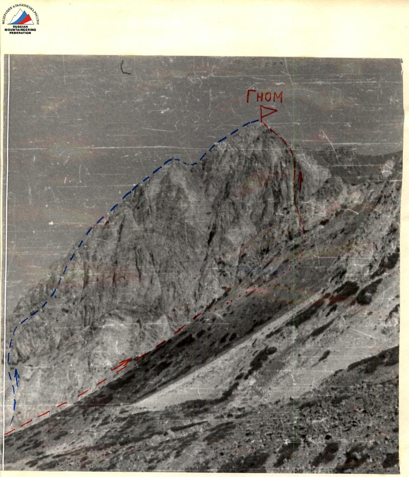
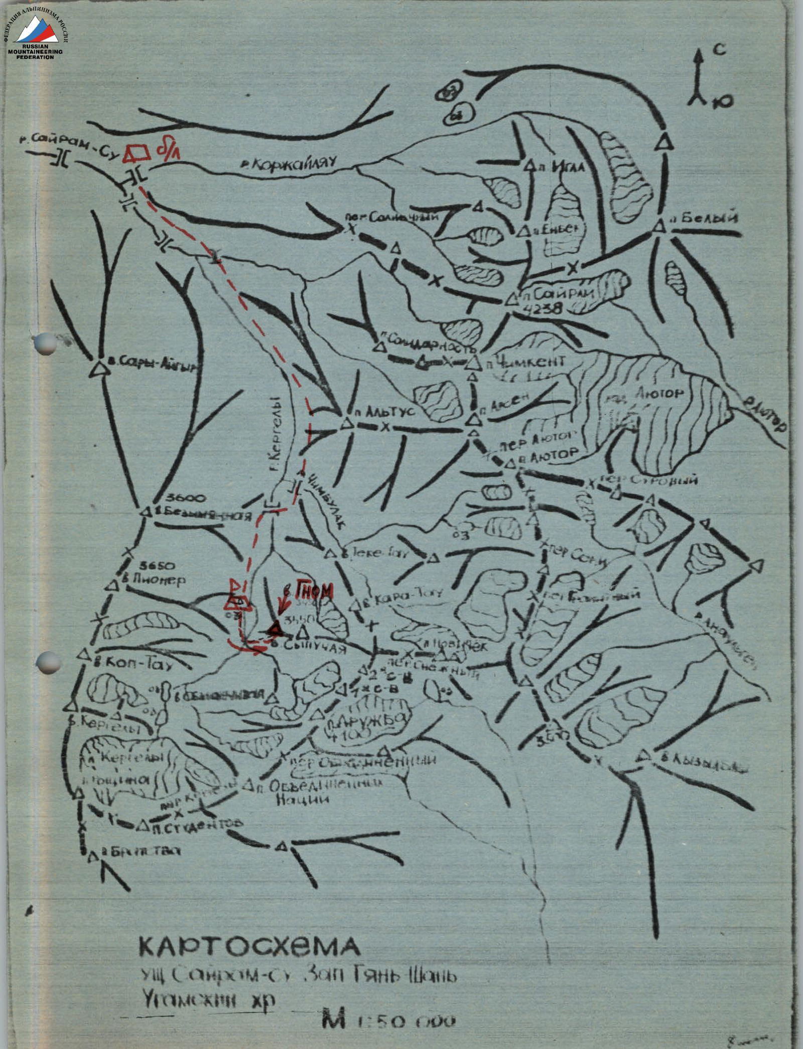
The summit "Gnom" (3450 m) is located in the Ugam ridge (Tian Shan), west of the summit "Sairamskaya" — the highest point in the area.
From the city of Chimkent, follow the asphalt road to the "Sinegorye" pioneer camp, then continue on a dirt road along the Sairam-su river to the base camp (see the map of the area). From here, follow a well-trodden trail along the Kergely river for 3 hours to reach the camping site near the lower moraine lake.
The approach to the start of the route is made via the moraine between the summits "Gnom" and "Sypuchaya", immediately from the lake, exiting onto the South ridge via a couloir used for descending from the summit "Gnom" (see the route photo).
The approach from the lake to the route takes 1 hour.

Route diagram (according to UIAA).
Route sections
R0 — start of the route. R1: 50 m, 45°, category 3. R2: 50 m, 60°, category 4. R3: 50 m, 35°, category 3. R4: 40 m, 40°, category 3. R5: 50 m, 60°, category 4. R6: 200 m, 35°, category 2. R7: 50 m, 80°, category 4. R8: 50 m, 90°, category 5. R9: 300 m, 20°, category 2, to the summit Gnom 3450 m.
Brief route description
The route begins with a steep couloir climb up characteristic light-colored rocks, followed by an exit onto a ridge with a steepness of 45°. Continue moving along the right side of the ridge. Climbing is complicated by a lack of holds and cracks, as well as brittle and crumbling rocks. The ridge leads to an internal corner with a steepness of 40°, followed by a passage under a gendarme, which is bypassed via narrow ledges on the right. A control cairn is located here.
Then, continue moving along a U-shaped couloir. Stay on the left side. After 200 m, the couloir leads to inclined, smoothed slabs, which lead to a chimney. Move carefully here (rockfall!). After complex climbing (about 100 m), there is an exit onto a gentle ridge with a steepness of 20–25° and a length of 300 m, which leads to the summit.
Descend onto a saddle towards the summit "Sypuchaya" and then down a couloir to the start of the route.