(А. Zakharchenko, turclubbarhan@yandex.ru)
Ascent Passport
- Western Tian-Shan, Ugam ridge (7.11), Sayram-Su gorge.
- Gagarin's peak 4000 m from the west along the south-eastern ridge from the west.
- Proposed category 2B, first ascent.
- Route type: rock (at the time of passage — heavily snowed).
- Height difference of the route — 250 m (GPS).
Route length — approx. 700 m, including sections of category II — 160 m. Average steepness of technical sections — up to 70°.
-
No pitons were left on the route.
-
Team's travel time — 7 hours, one day (+ 3 hours approach from Base Camp).
-
Descent from the summit via the ascent route.
-
Leader: Ildar Gabbasov — Candidate Master of Sports, instructor category 3 (Almaty, RK) Participants:
-
Alexander Zakharchenko — 3rd sports category (Baikonur, RF).
-
Yuri Belikov — 3rd sports category (Baikonur, RF).
-
Grigory Prokhorov — 3rd sports category (Baikonur, RF).
-
Denis Chepelev — 3rd sports category (Baikonur, RF).
-
Coach: Master of Sports of the USSR M. S. Levin, instructor category 1, badge 036 (Chelyabinsk, RF).
-
Departure from Base Camp 1760: at 12:00 on August 5, 2013.
Route started from Camp 2400: at 4:30 on May 6, 2013. Summit reached: at 12:00 on May 6, 2013. Return to Base Camp 1760: at 21:00 on May 6, 2013.
- Ascent by the team of the tourist club "Barhan" (Baikonur, Russia) organized by the educational department of the 5th Mountain Festival "SAYRAM 2013"
- Responsible for the Report: A. Zakharchenko, turclubbarhan@yandex.ru 87713015464
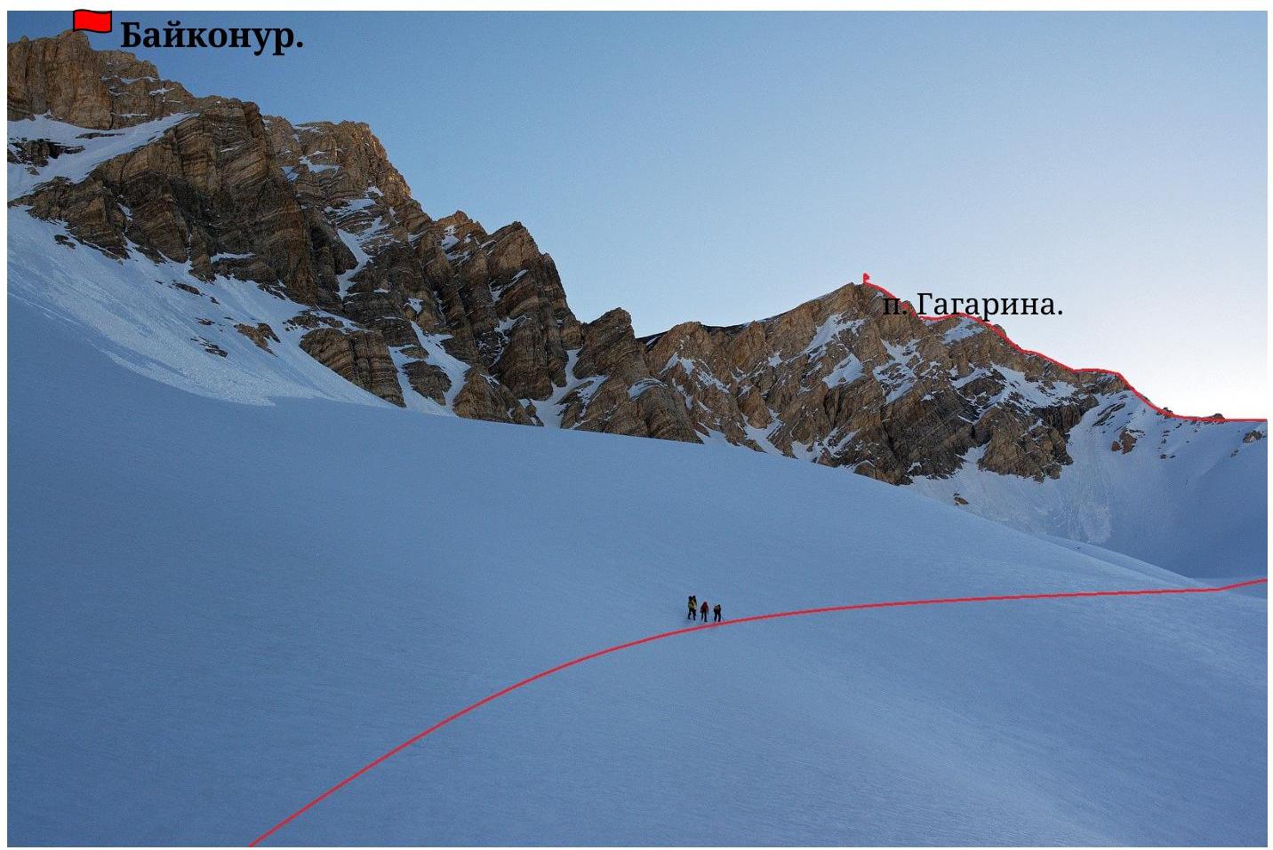
Photo #1 (author — A. Zakharchenko). On the approach to the pass.: General view of the first ascent object Note: All shooting points are indicated on
the Map
 MAP
(Photo
#2):
MAP
(Photo
#2):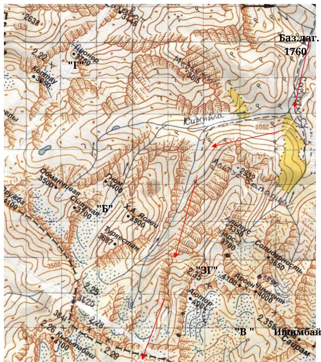 Baikonur
3990
Baikonur
3990
Δ Gagarina 4000
«A»
Notes on the map (grid: M 15 mm = 500 m):
- Geographical coordinates of the first ascent object: Latitude 42°06′34.7″ N.
Longitude 70°28′31.1″ E. 70 km along the asphalt road from Shymkent to the second checkpoint — 1 hour drive. The Sayram-Su river gorge is fenced off by guest houses of a sheikh from the state of Qatar. Bypassing the fence to the right along the slope — 1 hour to 1760.
- From Base Camp 1760, ascend along the Sayram-Su gorge to the confluence with the Kirgiyly river (30 minutes),
turn right and go up along Kirgiyly for 45 minutes to the confluence with the Chimbulak river 2000, here
turn left and ascend along the gorge (so-called "Wild Climbers") to 2400 m, to a wide meadow («ZG») — «Green Hotel» (2–2.5 hours from 1760).
Here is a bivouac, and early in the morning, depart upwards to 2800 — confluence of streams from under the passes (left).
and Snowy (right). From here, the first ascent object is clearly visible (from 2400, in summer — 6–8 hours).
Table of main route characteristics
| Summit (4000 m GPS) | ||||||
|---|---|---|---|---|---|---|
| 4-5 | 40 m #6 | 70 | Rocky | 2 | 1 | Alternating |
| 3-4 | 60 m #6 | 10 | Heavily snowed | 1 | - | Simultaneously |
| 2-3 | 120 m #5 | 70 | Rocky, snowy | 2 | 2 | Simultaneously |
| 0 | ||||||
| :-- | :-- | :--: | :--: | :--: | :--: | :--: |
| 1-2 | 150 m #4 | 50 | Heavily snowed | 1 | - | Simultaneously |
| 0-1 | 300 m #3 | 40 | Snowy | 1 | - | Simultaneously |
| Section/time | Length m / «№» photo | Steepness deg | Terrain type | cat. diff | Number of belay points | Movement type |
Photo #3 start of the route
(0–1)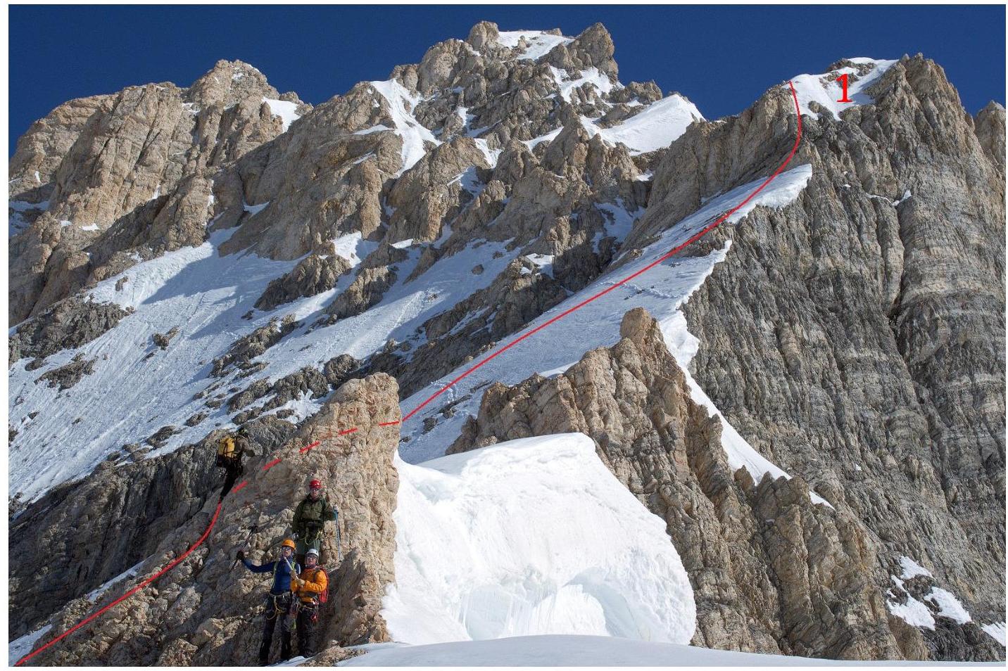
0 .


