Ascent Passport
- Ascent class — technical.
- Ascent region — Tian Shan, Teskey Ala-Too.
- Peak, its height and ascent route — 4550 m, via the Southeast ridge.
- Expected difficulty category — 3B.
- Route characteristics: height difference — 650 m, average steepness — 30–35°. Section lengths: 1st difficulty category — 150–200 m, 2nd difficulty category — 400–450 m, 3rd difficulty category — 600–650 m, 4th difficulty category — 20 m, 5th difficulty category — 5 m.
- Pitons hammered: for belay — 7 rock, for creating RPE (Rope Protection Equipment) — 3 ice, expansion bolts — none.
- Number of climbing hours — 5 h 30 min.
- Number of overnight stays and their duration — none.
- Surname, name, patronymic of the leader and participants, their sports qualification:
- Bochkov Dmitry Sergeevich — leader, Candidate for Master of Sports
- Musienko Vyacheslav Vladimirovich — participant, 1st sports category
- Potashov Alexander Ivanovich — participant, 1st sports category
- Gorodensky Boris Karlovich — participant, 2nd sports category
- Averina Natalia Alexandrovna — participant, 2nd sports category
- Surzhanskaya Lyubov Anatolyevna — participant, 2nd sports category
- Team coach — Bochkov D. S.
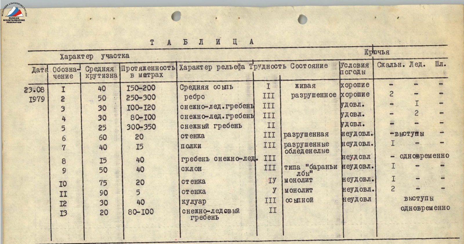
Table
| Date | Designation | Average steepness | Length in meters | Nature of terrain | Difficulty | Condition | Weather conditions | Rock | Ice | Exp. |
|---|---|---|---|---|---|---|---|---|---|---|
| 23.08 | R1 | 40° | 150–200 | Medium scree | 1 | Loose | Good | — | — | — |
| 1979 | R2 | 50° | 250–300 | Edge | 3 | Destroyed | Good | 2 | — | — |
| R3 | 30° | 100–120 | Snow-ice ridge | 3 | — | Fair | — | 1 | — | |
| R4 | 30° | 80–100 | Snow-ice ridge | 3 | — | Fair | — | 2 | — | |
| R5 | 25° | 300–350 | Snow ridge | 2 | — | Fair | — | — | — | |
| R6 | 60° | 20 | Wall | 3 | Destroyed | Poor | — ledges | — | — | |
| R7 | 40° | 15 | Shelves | 3 | Destroyed | Poor | 1 | — | — | |
| icy | ||||||||||
| R8 | 15° | 40 | Snow-ice ridge | 3 | — | Poor | — | Simultaneously | — | |
| R9 | 50° | 40 | Slope type "ram's foreheads" | 3 | — | Poor | 1 | — | — | |
| R10 | 75° | 20 | Wall | 4 | Monolith | Poor | 1 | — | — | |
| R11 | 90° | 5 | Wall | 5 | Monolith | Poor | 2 | — | — | |
| R12 | 30° | 40 | Scree gully | 3 | Scree | Poor | ledges | — | — | |
| R13 | 20° | 80–100 | Snow-ice ridge | 2 | — | — | — | Simultaneously | — |
Brief description of approaches to the route
Peak 4550 m is located in the watershed part of the northwest spur of the Teskey Ala-Too ridge. The spur is located between the Aylyanysh and Archaly-Tor rivers (see map diagram).
From Przhevalsk city by car to the Jety-Oguz resort, then along the Jety-Oguz gorge to the Telety river — 12 km. Further, the car cannot pass. Convenient place for a camp.
From the mouth of the Telety river along the right (orographically) bank of the Jety-Oguz river, and then the Aylyanysh river in the direction of the main peak of the Jety-Oguz wall — 4 hours walking.
Before the tongue of the Aylyanysh glacier:
- Climb to the left lateral moraine.
- Under the waterfall — a good place for a assault camp.
- There is firewood.
4 hours walking.
From the waterfall along the right (orographically) moraine — climb along the glacier to the gravel plateau. Cross the plateau in the lower part to the left. Along the grassy slopes, then along the scree — approach under the tongue of the leftmost branch of the Aylyanysh glacier.
Climb to the glacier along the scree on the left. Movement along the glacier in teams (glacier is closed, there are crevasses).
Along the left edge of the glacier under the slopes of peak 4550 m — approach under the route.
From the camp under the waterfall to the start of the route — 3.5–4 hours walking. Thus, approaches to the route are:
- 2 hours by car to the Telety river
- 7.5–8 hours walking
Brief description of the route
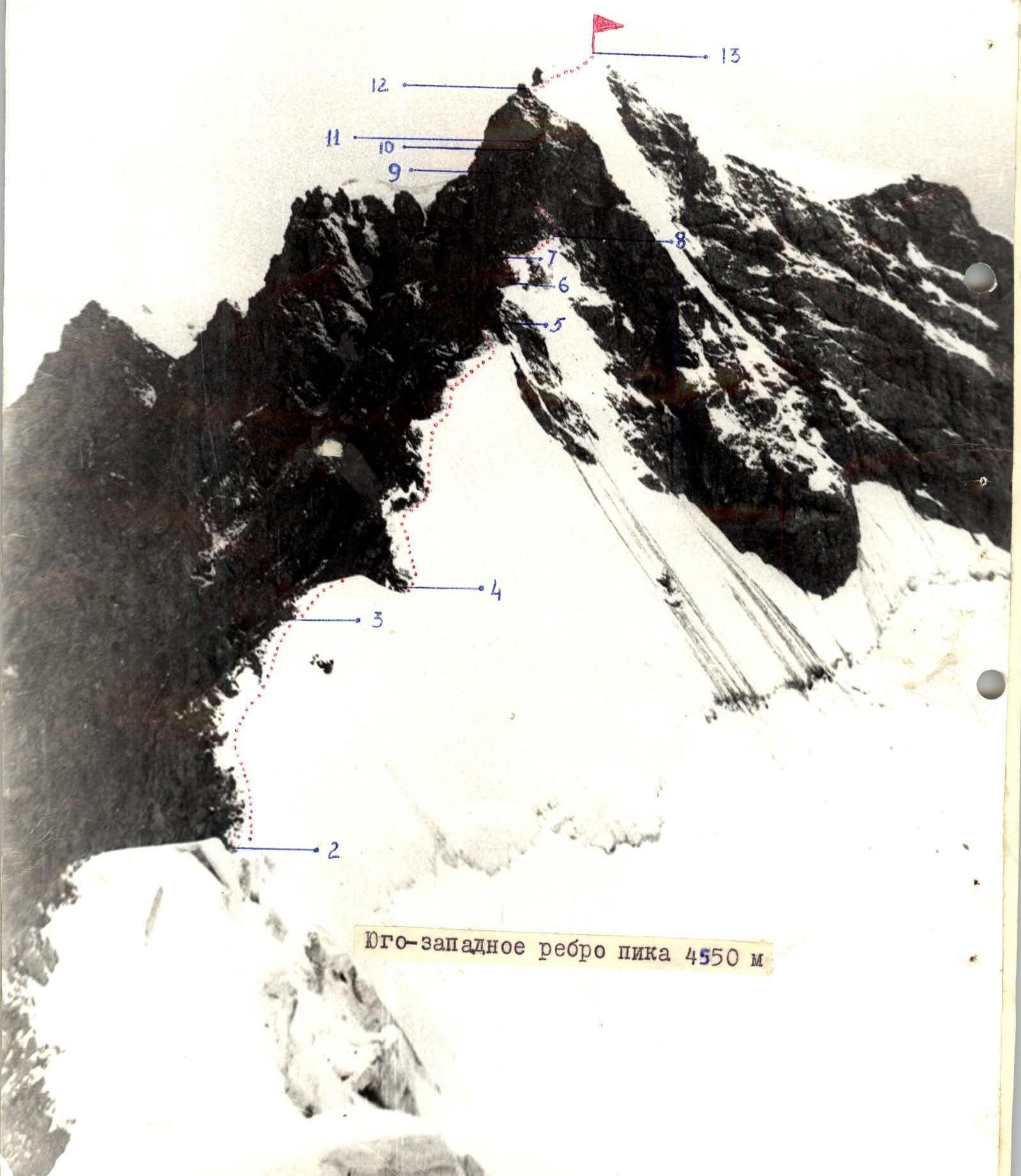
Along the wide middle scree — climb to the base of the scree counterfort (150–200 m, section R1). Along it — exit to the main ridge (section R2).
Exit to the ridge to the right of the saddle, then — to the left along the ridge towards the summit.
Climb to the gendarme on the right along the snow-ice slope (section R3). From the top of the gendarme — descent to the saddle (80–100 m, section R4).
Along the snow ridge 25°, 300–350 m, with cornices to the northeast — approach under the rocky heavily destroyed wall (section R5).
The wall (section R6) turns into steep scree shelves. The rocks are covered with ice, sprinkled with snow (section R7).
Along the snow-ice ridge (section R8) — approach under the base of the summit bastion.
Bypassing the bastion to the left upwards — climb to the scree shelf (section R9). Place for organizing belay.
From here to the right upwards 20 m, 75° (section R10) — rocks of medium difficulty, turning into a wall 5 m, 90° — difficult climbing (section R11).
The wall leads to a scree gully (section R12), overhanging the wall.
Along the snow ridge — exit to the summit (section R13).
The summit is a snow ridge with islands of rocks on the southwest side. A cairn is built on one of them.
Descent along the northwest ridge.