Ascent Passport
I. Climbing category — technically challenging. 2. Ascent area — Tian Shan, Terskey Alatau ridge. 3. Peak, its height, and ascent route — Peak 4400, height 4400 m, first ascent, via the northern ridge. 4. Estimated category of difficulty — 2B. 5. Route characteristics: height difference — 500 m, average steepness — 35–40°, length of sections — R1 – 300 m, R2 – 400 m, R3 – 250 m, R4 – 100 m, R5 – 55 m.
- Pitons driven:
| For belay | For creating ITO | |
|---|---|---|
| Rock | 6 | 0 |
| Ice | 2 | 0 |
| Bolt | 0 | 0 |
- Number of climbing hours — 6 hours.
- Number of nights and their characteristics — the group did not spend the night on the route. It is possible to organize overnight stays on the ridge.
- Surname, name, patronymic of the leader and participants, their sports qualification:
Vorobyev Anatoliy Borisovich, 1st sports category — leader, Bolonin Vladimir Petrovich, 1st sports category — participant, Keytelgisser Ilya Isaevich, 1st sports category — participant, Rapoport Fayva Abramovich, Master of Sports — participant.
- Team coach — Tunik Alfred Lvovich, Master of Sports.
- Date of departure and return:
August 13, 1977 — departure,
August 15, 1977 — return.
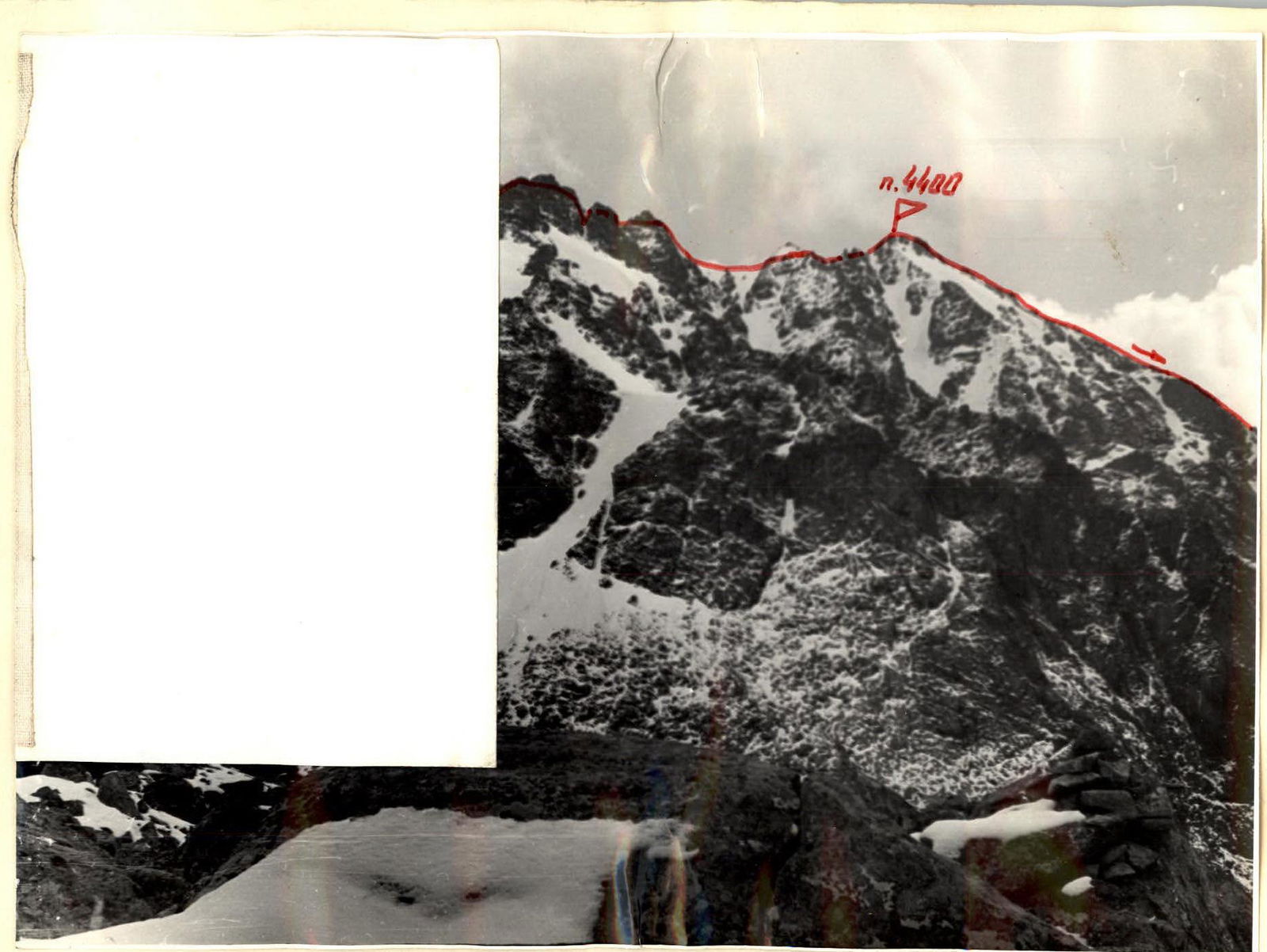
Peak 4400
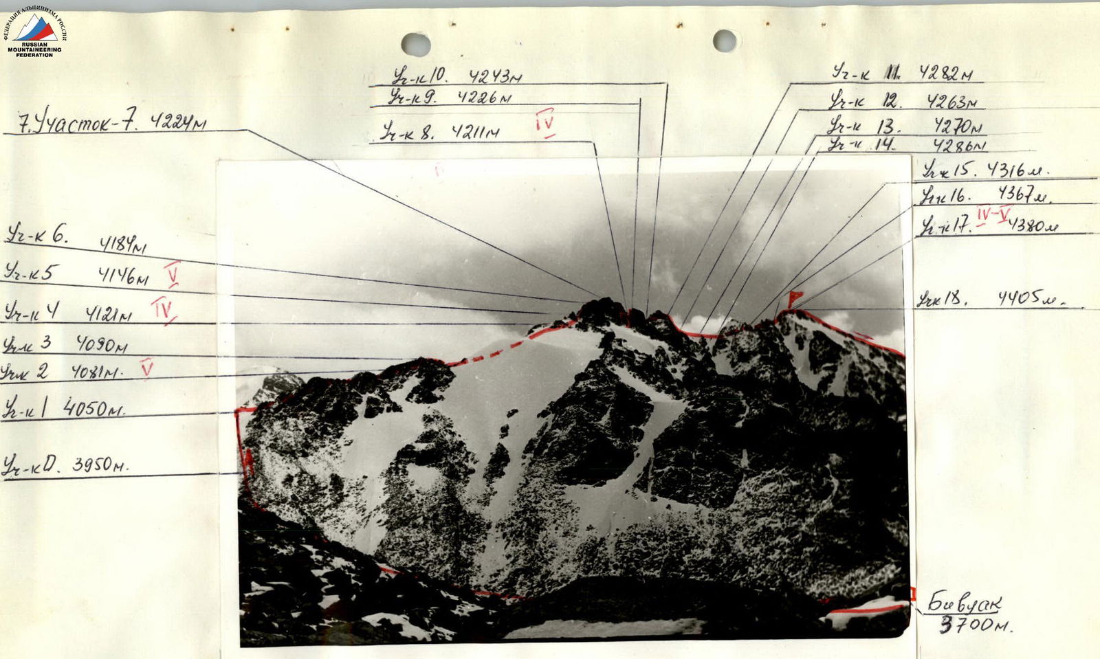
Photo of the peak
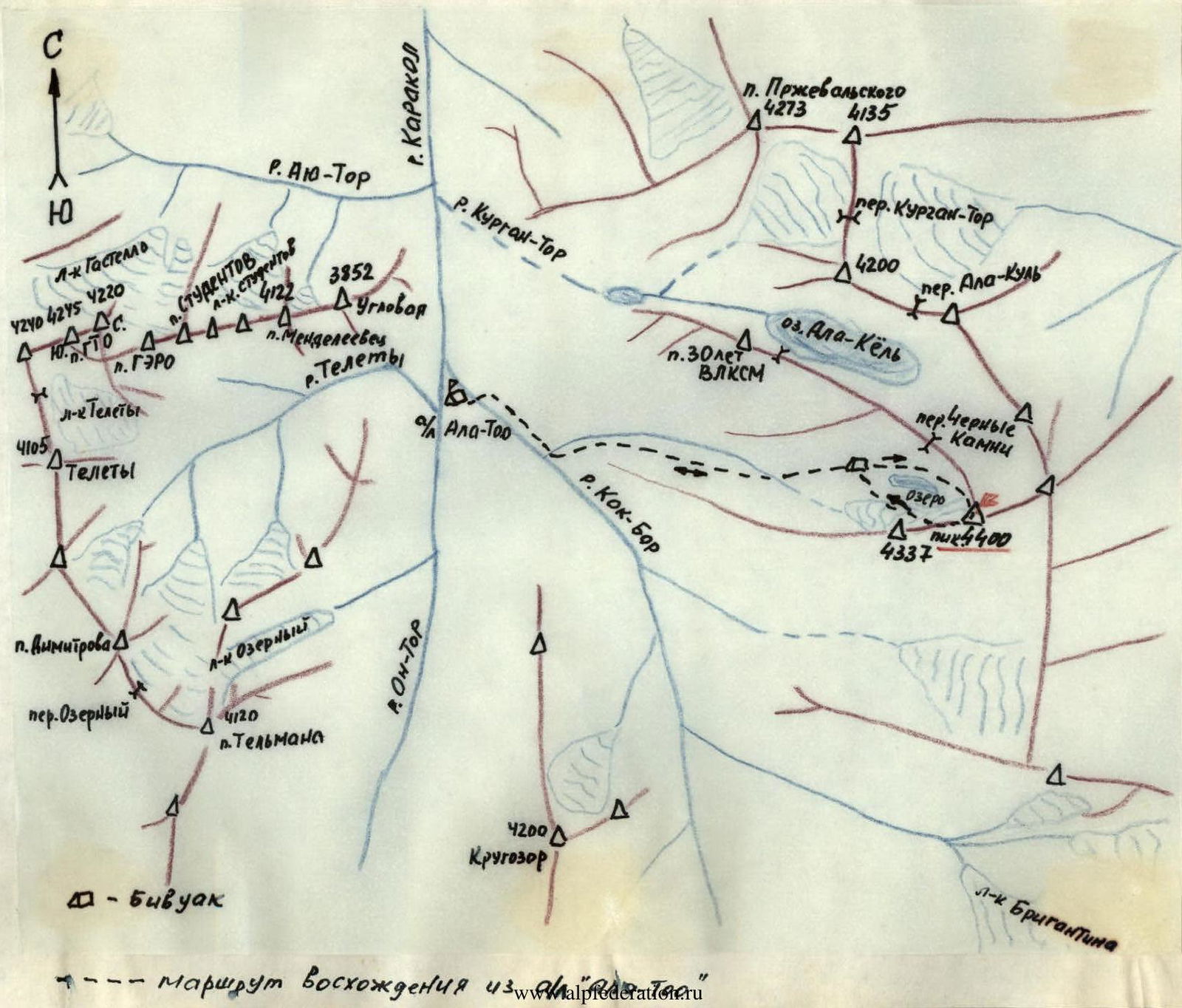
Cartographic scheme of the ascent area to Peak 4400.
Description
ROUTE OF THE FIRST ASCENT TO PEAK 4400 VIA THE NORTHERN RIDGE (APPROXIMATELY 3B CATEGORY OF DIFFICULTY), MADE BY THE GROUP OF ALPLAGER "ALA-TOO" UNDER THE LEADERSHIP OF VOROBYEV A.B. IN THE PERIOD FROM AUGUST 13 TO AUGUST 15, 1977.
The peak 4400 m is located at the end of a mountain spur extending north from the Terskey Alatau ridge in the area of the MGMI peak. Peak 4400 borders the glacier to the northeast, which feeds Lake Ala-Kol. The northern ridge of the peak approaches the "Black Stones" pass, connecting the Kok-Bor and Kurgan-Tor gorges.
Day 1. From the "Ala-Too" alpine camp, walk for 1 hour up the Kok-Bor gorge and ascend along the canyon (first across the scree, then across the grassy slopes) to the second branch on the right (orographic) side of the gorge, to the lake under the "Black Stones" pass — bivouac. The ascent time from the trail to the lake is 2–2.5 hours.
Day 2. From the overnight stay, proceed along the lake towards the pass (15–20 minutes), then ascend to the right towards the narrow snow bridge at the base of the northern ridge of Peak 4400. Ascent:
- first across the scree,
- then along the boundary of the rocks and the snowy slope descending from the bridge.
In the upper part under the snow, there is ice, the slope steepness is 40–45°. It is possible to move to the rocks. Belay is necessary. The ascent time to the bridge is 1–1.5 hours.
The beginning of the route is on the left side of the ridge, 120 m across easy rocks. Exit to the ridge to a 10-meter wall, which is climbed with piton belay. Further, 120 m along the ridge to the first sentinel. The ascent to the sentinel is across a snow-ice slope — 50–60 m. In the upper part of the slope, when approaching the rocks, piton belay through ice screws. The rock wall is 40 m, climbed with piton belay. The upper part of the sentinel is bypassed on the right across snowy rocks. Descent down a sloping shelf, 20 m, and subsequent ascent to the bridge on the main ridge (piton belay). Across rocks of medium difficulty, 100 m along the ridge, and ascent to the second sentinel. Descent from the sentinel via a 20 m rappel. The snowy ridge with a cornice (30–40 m) is traversed with careful belay. The "sharp" sentinel is bypassed on the left across rocks and shelves with alternating belay. 80 m along the ridge lead to the summit tower, which is climbed on the left part. A wall with a crack — 10–15 m is climbed with piton belay. Further, 40 m across simple rocks lead to the summit.
The ascent to the summit from the beginning of the route takes 6–7 hours.
Descent from the summit is along the southwestern ridge across easy rocks to a scree couloir, then down the couloir towards the bivouac. The descent takes 1.5 hours.
As a recommendation to subsequent climbers, it should be noted that the rocks on the route are mostly solid, and there are many places suitable for organizing belay. However, there are "live" rocks on the route.
The group considers the route logical and safe to pass and corresponding to the 3B category of difficulty.
Description compiled by A.B. Vorobyev
Table
Appendix 2
| № | Designation | Average steepness, degrees | Length, m | Terrain character | Difficulty | Condition | Weather conditions | Rock pitons | Ice pitons | Bolt pitons |
|---|---|---|---|---|---|---|---|---|---|---|
| 1 | R0–R1 | 30 | 200 | sheep's foreheads | II | icy | sun | ledges | – | – |
| 2 | R1–R2 | 15 | 120 | ridge | I | destroyed | – | simult. | – | – |
| 3 | R2–R3 | 60 | 10 | wall | V | monolith | – | 1 | – | – |
| 4 | R3–R4 | 15 | 120 | ridge | T | destroyed | – | simult. | – | – |
| 5 | R4–R5 | 30 | 50 | snow-ice | IV | – | cloudy, wind | – | 2 | – |
| 6 | R5–R6 | 70 | 40 | wall | V | snowy monolith | cloudy, wind | 3 | – | – |
| 7 | R6–R7 | 0 | 40 | shelf | III | snowy | cloudy, wind | ledges | – | – |
| 8 | R7–R8 | 40 | 20 | shelf | III–V | snowy | – | descent (right) | – | – |
| 9 | R8–R9 | 50 | 20 | couloir | IV–V | ice-snow | – | 1 | – | – |
| 10 | R9–R10 | 10 | 100 | ridge | II | slabs | – | ledges | – | – |
| 11 | R10–R11 | 40 | 60 | sentinel | III | slabs | – | ledges | – | – |
| 12 | R11–R12 | 70 | 20 | wall | III | monolith | – | rappel | – | – |
| 13 | R12–R13 | 10 | 40 | ridge | III | snowy cornice | – | ledges | – | – |
| 14 | R13–R14 | 15 | 60 | shelves | II | destroyed | sun | ledges | – | – |
| 15 | R14–R15 | 30 | 60 | ridge | I–II | snowy | – | simult. | – | – |
| 16 | R15–R16 | 40 | 80 | shelves | III | slabs | – | ledges | – | – |
| 17 | R16–R17 | 60 | 15 | crack | IV–I | monolith | – | 1 | – | – |
| 18 | R17–R18 | 40 | 40 | ridge | I | destroyed | – | simult. | – | – |
Time of departure from the bivouac — 4:30; time of return to the bivouac — 14:30. Climbing hours — 6.