Passport
Ascent to Peak 4337 via the Eastern Counterfort of the North Face, completed on August 9-10, 1980.
- Class of ascent — technical.
- Area of ascent — Eastern Tian-Shan, Karakol valley.
- Ascent route — Peak 4337 via the Eastern Counterfort of the North Face, approximately category 3B difficulty. First ascent.
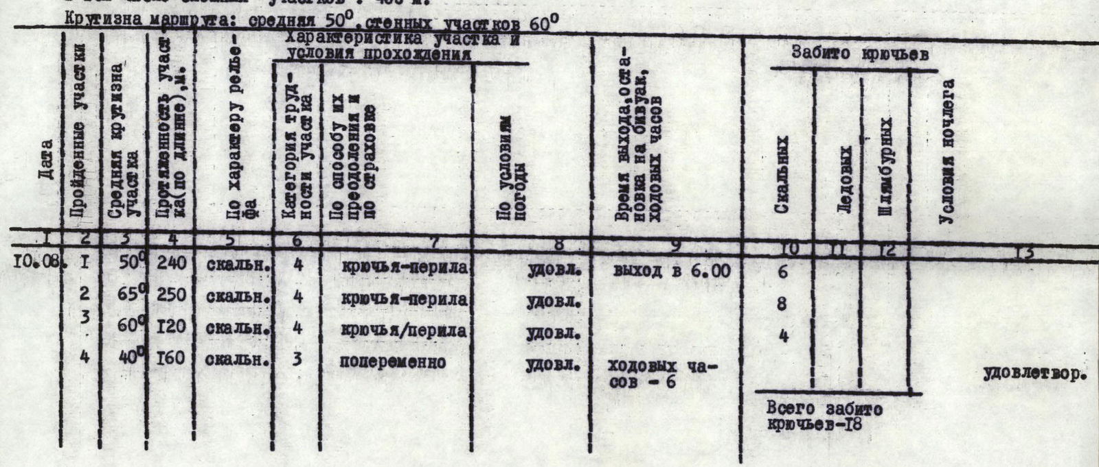
- Characteristics of the ascent: — route length — 800 m. — elevation gain — 500 m. — average slope of the route — 50°, wall sections — 60°.
- Pitons used: — rock pitons — 18, — ice screws — not used, — bolt pitons — not used.
- Total climbing time — 6 hours.
- Number of climbing days — 1 (not counting 1 day of approach).
- Number of bivouacs and their characteristics — none.
- Group composition: — Borisova Natalya Nikolaevna, 1st category, leader, — Ermakov Alexander Grigorievich, 1st category, — Polin Alexey Grigorievich, 1st category, — Seleznev Fedor Fadeevich, Candidate Master of Sports, — Vakhitov Shakir Yasherovich, 1st category, — Pepenko Vladimir Alekseevich, 1st category.
- The group is part of the LSS DSO "Trud" gathering, a/l "Alo-Too".
- Time of ascent — August 9-10, 1980.
Characteristics of the Ascent Object
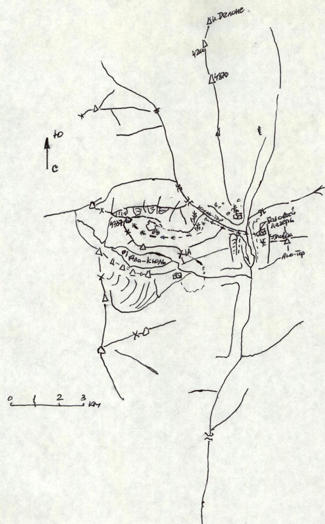
The Karakol valley area, located in the Eastern Tian-Shan, where the "Alo-Too" alpine camp is situated, is popular among climbers. It features well-known peaks such as Dzhigit and Karakol, with heights exceeding 5000 m, and many peaks of various difficulty categories.
The height of the peak that was the object of the ascent (4337 m) is lower than the aforementioned heights, but its convenient location relative to the alpine camp and the safety of the routes should attract the attention of climbers.
According to information obtained at the KSP and the alpine camp, it was confirmed that there had been no previous ascents to Peak 4337. Preliminary reconnaissance allowed for the selection of a route from the north. Among several possible ascent paths (approximately equivalent, assessed as category 3B difficulty), the route via the Eastern Counterfort of the North Face was chosen.
The route has the following key landmarks: a large slab at the initial part of the counterfort, ending in a ledge, a section of the counterfort above the ledge, a gendarme, a wall, and the summit tower.
The route via the Eastern Counterfort of the North Face is the most interesting. A characteristic feature of the ascent variant completed, as well as other possible variants, is that the most challenging rock sections are largely snow-free or clear of snow. The weather during the climbing season resembled that typical for the Bezengi area in the Caucasus: low temperatures on the routes, almost certain deterioration of weather in the second half of the day, and periods of severe bad weather lasting up to 2-3 days.
Overall, the ascent route, like the North Face, is sufficiently safe.
Description of the Ascent
The initial bivouac is located on the moraine (above the alpine meadows) within 40-50 minutes' walk from the start of the route.
The approach to the peak from the "Alo-Too" alpine camp takes about 3-4 hours. Initially, the path goes from the camp up the Koltor valley along a trail past the training rocks to a stream flowing from the left (orographically) valley (30-40 minutes). Then, the path goes left along the stream, on a trail leading to the Panoramic pass, emerging onto a plateau (alpine meadows) that extends to the right (1.5-2 hours). Initially, the trail goes to the left of the stream, then on the right side of the stream. Further along the left side of the stream, which turns together with the plateau, the path goes across alpine meadows, emerging onto a large moraine. Along the moraine is the approach to the route (1.5-2 hours).
The plateau narrows and ends in a cirque, which is closed by the distinctly prominent North Face of Peak 4337.
There are many places here suitable for a bivouac. There is water. From the bivouac sites to the start of the route is 40-50 minutes.
The ascent route proceeds as follows. Up snow-covered scree to a large slab (section R1 on photo 1), located in the center of the North Face (80-100 m). The entire route is clearly bounded by rock couloirs, partially filled with snow and ice. The slab is ascended on its left side via a vertical internal corner (160-180 m). Climbing is of moderate difficulty. Piton protection. Exit onto a wide snow-covered ledge, along which there is a traverse to the right and upwards (photo 2) for 30-40 m. Further, on the right part of the counterfort (section R2 on photo 1), ascent to a gendarme (200-250 m) and along a connecting ridge to the wall at the start of the summit tower. Direct ascent up the wall for 30-40 m (section R3 on photo 1). Climbing is difficult, with piton protection. On the connecting ridge, there is a control cairn.
In its upper part, the wall transitions into a rock ridge (60-70 m), see photo 3. Further along the snow-covered ridge of the counterfort (section R4 on photo 1), on simple rocks (150 m), is the exit to the summit of Peak 4337, where a cairn is located.
The group reached the summit at 12:00. The entire ascent path is quite logical and safe. Descent from the summit initially along the ridge, then down simple snow-covered rocks onto the moraine and along the approach path back to the alpine camp.
The route completed is logically divided into the following sections (see photo 1 and the table):
- R1:
- 2 ropes of scree slopes to the slab;
- 4 ropes of moderately difficult climbing up the internal corner of the slab;
- R2:
- 1 rope for traversing right and upwards along the ledge at the top of the slab;
- 4-5 ropes of difficult climbing on the right part of the counterfort;
- R3:
- 1 rope along the connecting ridge to the wall;
- 2 ropes of difficult direct climbing up the vertical wall;
- R4:
- 3-4 ropes along the snow-covered ridge of the counterfort to the summit.
Table of Main Characteristics of the Ascent Route
Ascent route: Peak 4337 via the Eastern Counterfort of the North Face (approximately category 3B difficulty).
Elevation gain of the route: 500 m.
Including challenging sections: 400 m.
Slope of the route: average 50°, wall sections 60°.
Evaluation of the Completed Route by Participants
Considering the presence of several fairly long sections of relatively complex climbing that required the use of nearly two dozen rock pitons, the route length of almost 800 m, despite the peak's relatively lower height compared to other peaks in the area, and based on a comparison with other routes in the area of similar difficulty categories and taking into account the experience of the group members, the route to Peak 4337 via the Eastern Counterfort of the North Face corresponds to category 3B difficulty.
A distinctive feature of the route is that it is two-thirds composed of rocks that are relatively snow-free. The peak's location is sufficiently close to the "Alo-Too" alpine camp.
The weather during the ascent was satisfactory, allowing the group to successfully complete the ascent according to their planned tactical plan.

Photo 2