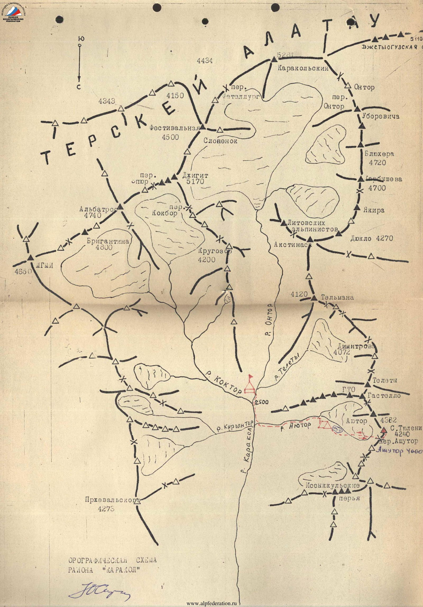
TIAN-SHAN TERSKEI-ALATAU RANGE (Karakol gorge)
S. Tyulenina Peak (4240 m) via Ashutor Pass
The route is approximately Category 3B, combined
Sitchikhin Yu.V., Ryabukhin A.G., Meshkova N.B., Karpenkov M.N., August 12, 1982
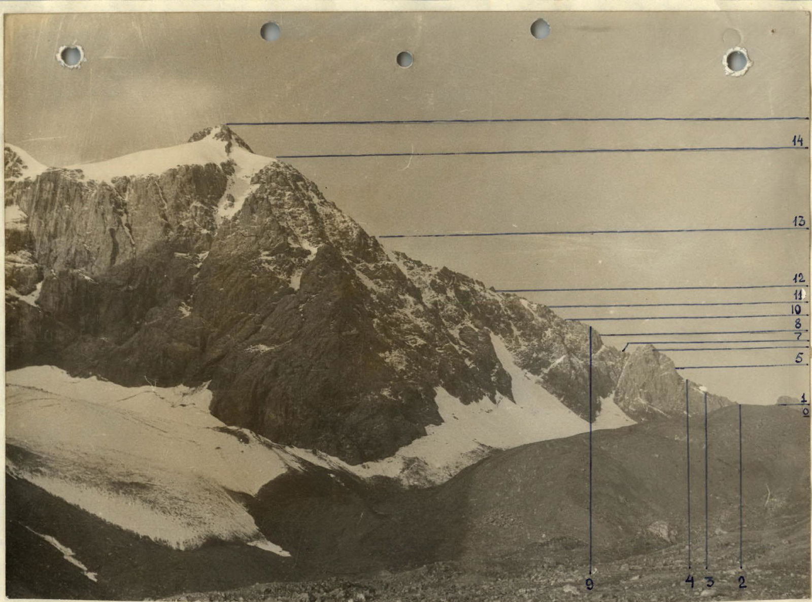
Photo 1. General view of the summit

Photo 2. Fragment of the general view (bastion)
Brief description of the approach to the route
The initial bivouac is located by a lake under the northern slope of Ayuter Peak. The approach here along the trail from the Karakol River gorge takes 3 hours.
From the bivouac, bypassing the lake on the left, ascend via large moraine scree and continue moving along the moraines in a general northwest direction towards Ashutor Pass. The pass is located between S. Tyulenina Peak and Ashutor Peak. Its height is about 3700 m.
Near the pass, the moraine gives way to a glacier with minor crevasses. The approach to the pass takes 1 hour.
The ascent from the glacier to the pass is via large scree (snow patch) stretching about 60–70 m. The pass cairn is located in the right depression of the pass.
| Date, time | Notation | Average steepness, degrees | Length, m | Terrain characteristics | Difficulty | Condition | Weather conditions | Pitons (rock) | Notes |
|---|---|---|---|---|---|---|---|---|---|
| 6:30 | R0–R1 | 50 | 40 | Rocky couloir | 2 | Icy | Cloudy | Control cairn on Ashutor Pass | |
| 7:00 | R1–R2 | 60 | 10 | Diagonal slab | 3 | Monolithic | — | 1 | |
| 8:00 | R2–R3 | 35 | 160 | Chain of gendarmes | 2 | Destroyed | — | ||
| 8:40 | R3–R4 | 70 | 25 | Crack with a plug and a wall | 4 | Monolithic | — | 2 | |
| 9:00 | R4–R5 | 50 | 55 | Slabs | 3 | Monolithic | — | 1 | |
| 9:25 | R5–R6 | 45 | 30 | Diagonal ledge left, corner | 3 | Snow-covered | — | 1 | |
| 9:50 | R6–R7 | 40 | 45 | Alternating slabs | 2 | Loose rocks | — | ||
| 10:30 | R7–R8 | 80 | 40 | Inner corner, ledge | 4 | Icy | — | 4 | |
| 11:00 | R8–R9 | 80 | 35 | Inner corner | 4 | — | — | 4 | |
| 11:30 | R9–R10 | 35 | 120 | Gendarmes with 3–5 m walls | 2 | Snow-covered | — | ||
| 11:50 | R10–R11 | 80 | 18 | Inner corner with a crack | 4 | Icy | Snowing | 2 | |
| 12:20 | R11–R12 | 30 | 150 | Chain of walls and gendarmes | 1 | Snow-covered | — | ||
| 12:40 | R12–R13 | - | 130 | Snow-ice ridge with gendarmes | 1 | — | Heavy snowfall | Control cairn | |
| 13:00 | R13–R14 | - | 180 | Snow-ice ridge | 1 | — | — | ||
| 13:30 | R14–R15 | 35 | 120 | Summit rock tower | 3 | Snow-covered | — | Summit cairn |
The descent from the summit is via the ascent route. On sections R10–R11, R8–R9, R7–R8, rappel down was used, with 3 rock pitons hammered in. The descent took 4 hours.
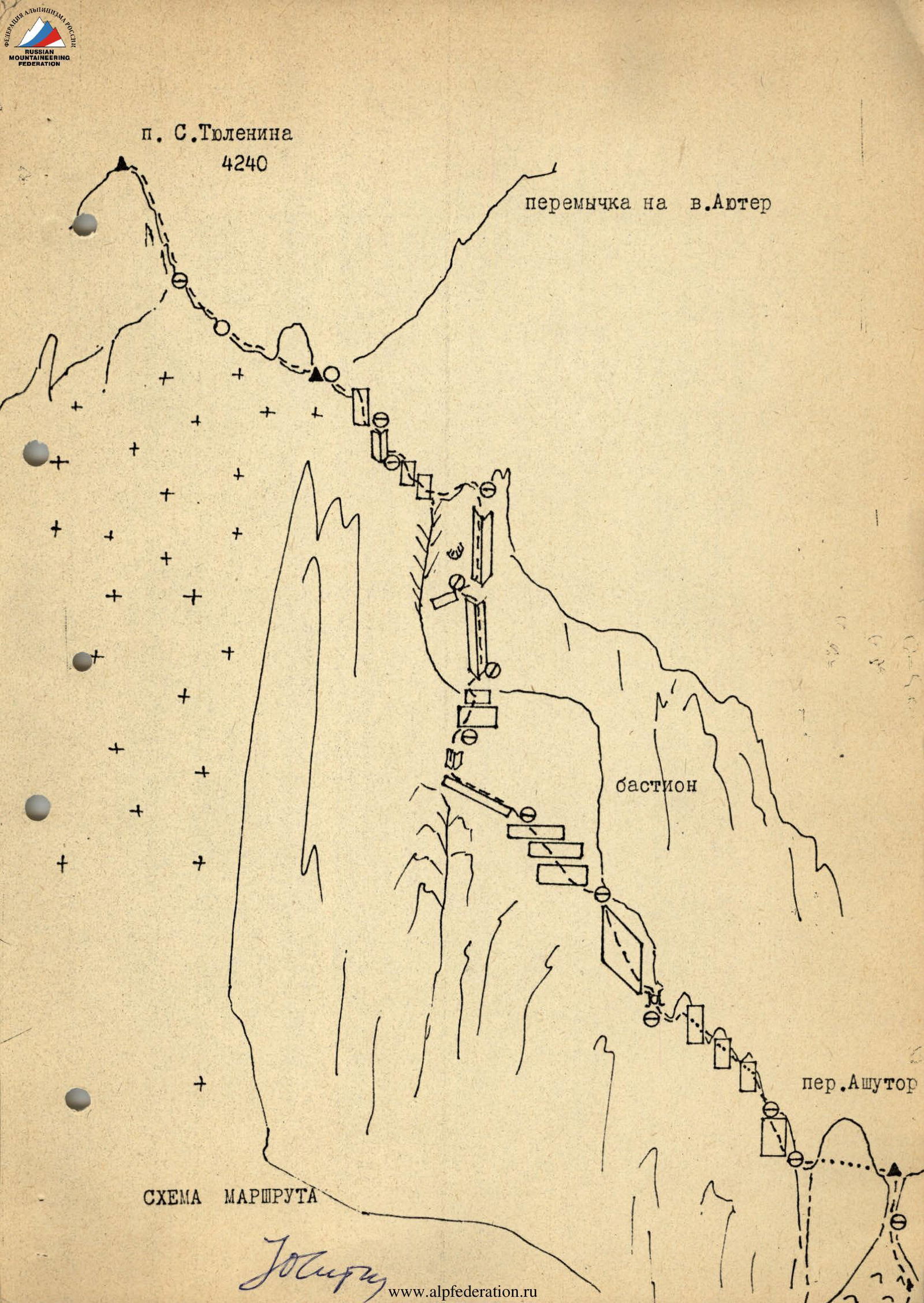
Description of the route to S. Tyulenina Peak (4240 m) via Ashutor Pass
From the campsite under Ayuter Peak (by the dammed lake), ascend via moraine to Ashutor Pass. The ascent to the pass is via the right (here and further - in the direction of travel) scree couloir and simple short rocks. Control (pass) cairn. Overall, the route follows the NW ridge of S. Tyulenina Peak. Initially, the pass gendarme is traversed, followed by an ascent along an inclined slab (10 m). Then, a chain of low, destroyed gendarmes is traversed, mostly directly. Belays were organized by wrapping the rope around outcrops. Through a small crack in the ridge (with a plug), exit onto a 25 m wall facing east. Further, approach the bastion blocking the ridge. Initially, ascend via 55 m slabs, then along a diagonal ledge left to the edge of the wall. Via a short inner corner, exit to slabs with a steepness of 45–50°, which are traversed with protection through outcrops. From the top of the bastion, a small descent via scree into a depression to the junction of the main, NW, and lateral ridges. Ascent via the right inner corner at the junction of these ridges - 75 m. Midway, there is a small ledge for organizing piton protection and receiving companions. Further, via low walls (3–5 m) and through an inner corner (18 m), approach along the ridge to the last gendarme, where the rocky ridge drops down to the left via a snow-ice slope with a steepness of 60°. Near the gendarme - a control cairn. Stick to rocky outcrops - ascend via the snow-ice section of the ridge (300 m) to the summit base of S. Tyulenina Peak. Ascent via destroyed simple rocks to the summit - 7–8 hours from the campsite. The descent is via the ascent route. On the descent, 3.5 rappels (40 m) were organized, with 3 loops and pitons left behind.
The total time for the route is 10–12 hours.

Photo 5. 75-meter inner corner