Ascent Passport
I. Ascent class. Technical
- Ascent area, ridge. Tian Shan, Terskey Alatau
- Summit, its height, route. Peak Tashtanbek 4710 m, via the northwest wall.
- Proposed difficulty category. 6B
- Route characteristics:
height difference 1070 m, length of sections Rн — R1 cat. sl. 1040 m, average steepness 76°
- Pitons driven: for belaying, for creating artificial holds.
rock — 157, 30 ice — 44, 11 bolts — 5, 3
- Total hours of climbing 93.5
- Number of nights and their characteristics: 8 nights
1st — lying on the glacier under the wall, 2nd — hanging, 3rd, 4th, 5th — sitting, 6th — hanging, 7th, 8th — semi-reclining
- Name of the team leader, participants, and their qualifications
team leader Zhurzdin Vladimir Iosifovich — Master of Sports, Gladchenko Vladimir Isaakovich — Candidate for Master of Sports, Ponchuk Valentin Lavrentyevich — Master of Sports, Podymov Evgeny Vasilyevich — Candidate for Master of Sports. 10. Team coach Ponchuk V.L. 11. Date of departure and return
July 21 — July 30, 1977
3480
July 21–22, 1977
Sheet | Doc. No. | Signature | Date | Sheet | Sheets
Developed.
Verified.
T. control.
N. control.
Approved.
Brief Geographical Description of the Area and the Ascent Object
Approach to the Route
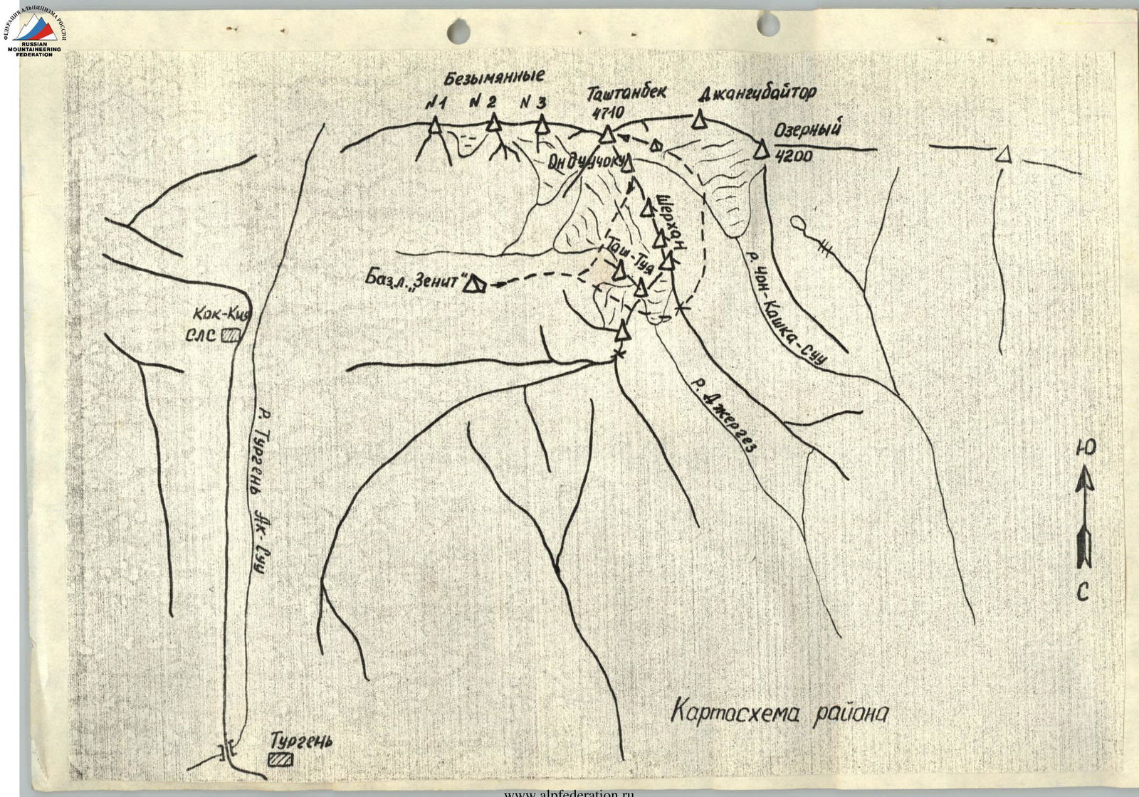
Peak Tashtanbek (4710 m) is located in the upper reaches of the eponymous lateral valley, flowing into the Turgen valley, along which the well-known road to Sarydzhas runs, near the peaks of Khan-Tengri and Pobeda.
This is the eastern part of the Terskey Alatau ridge, which is poorly developed in terms of mountaineering.
It is known that in 1953, a group of Uzbek climbers led by Elchibekov ascended Peak Tashtanbek. This ascent was classified as a route of 4A category difficulty, after which there were no ascents to the peak.
From the city of Przhevalsk to the village of Turgen, you can take a regular bus (2 hours), then cargo vehicles mainly go to the village of Kok-Kiya (Snow Avalanche Station (SAS)) (20 km); here the road turns left to the Chong-Ashu pass and further to Sarydzhas.
To get to the Tashtanbek-Tor valley, you need to cross to the left bank of the Turgen-Ak-Su river, 1.5–2 km above the village of Kok-Kiya, and enter the lateral valley, rising to the west. After 6 km, a panorama of the northeastern and northern walls of the peaks Tashtanbek and the adjoining massifs Onduuchoku and Sherkhan opens up.
The valley begins with two steep glaciers descending from the northeastern and northern slopes of Peak Tashtanbek. Going northeast, it gradually deviates to the east and, slightly decreasing, exits to the Turgen valley.
The base camp of the Zenit Sports Society (DSO) was set up 1.5 km from the mentioned glaciers (3100 m) on the grassy slopes of the valley sides.
To the west, behind the massifs of the peaks Onduuchoku and Sherkhan, extending from Peak Tashtanbek to the north, lies the Kashka-Su valley, descending into the Ak-Su valley.
To the right, if you look to the west, in front of the Sherkhan massif stands a two-humped peak Tas-Tuya (“stone camel”), on which the climbers of the gathering had laid a route of approximately 3B category difficulty.
To get to the Kashka-Su valley, from where the route of the Uzbek climbers began and our route on the NW wall started, it is necessary:
- To pass a small ice circus located in front of the peak Tas-Tuya;
- To climb to the saddle between this peak and a nameless peak (250 m, 45°).
From here:
- To the right, to the north, the Jergez valley descends sharply;
- To the northwest, along the left lateral ridge of this valley, there is a descent (450 m) into the Kashka-Su valley.
After 400–450 m of descent along the destroyed, not very steep ridge, a scree slope goes down to the left, from which the tongue of the Kashka-Su glacier is visible.
Having descended to the grassy slopes, you should turn left to the south and climb along the glacial tongue towards the beginning of the route.
After 2 km, the path logically transfers to the lateral moraine of the glacier, and in the upper part, the last 2 km go along the glacier itself.
The upper reaches of this valley are a fairly powerful glacial circus formed by the peaks:
- Onduuchoku;
- Tashtanbek;
- Dzhangibaytor;
- Ozerna.
It descends to the north, then, turning to the west, exits into the Aksu valley.
Climatic conditions in the area are apparently determined by the proximity of Lake Issyk-Kul and the fairly high Terskey Alatau ridge, which captures most of the precipitation. Therefore, frequent:
- Rains;
- Thunderstorms;
- Snowfalls.
So, in the period from July 5 to August 5, snow fell three times in the Tashtanbek-Tor valley, 12 days were rainy and quite cold. The snow line in the valleys lies at an altitude of 3500–3600 m.
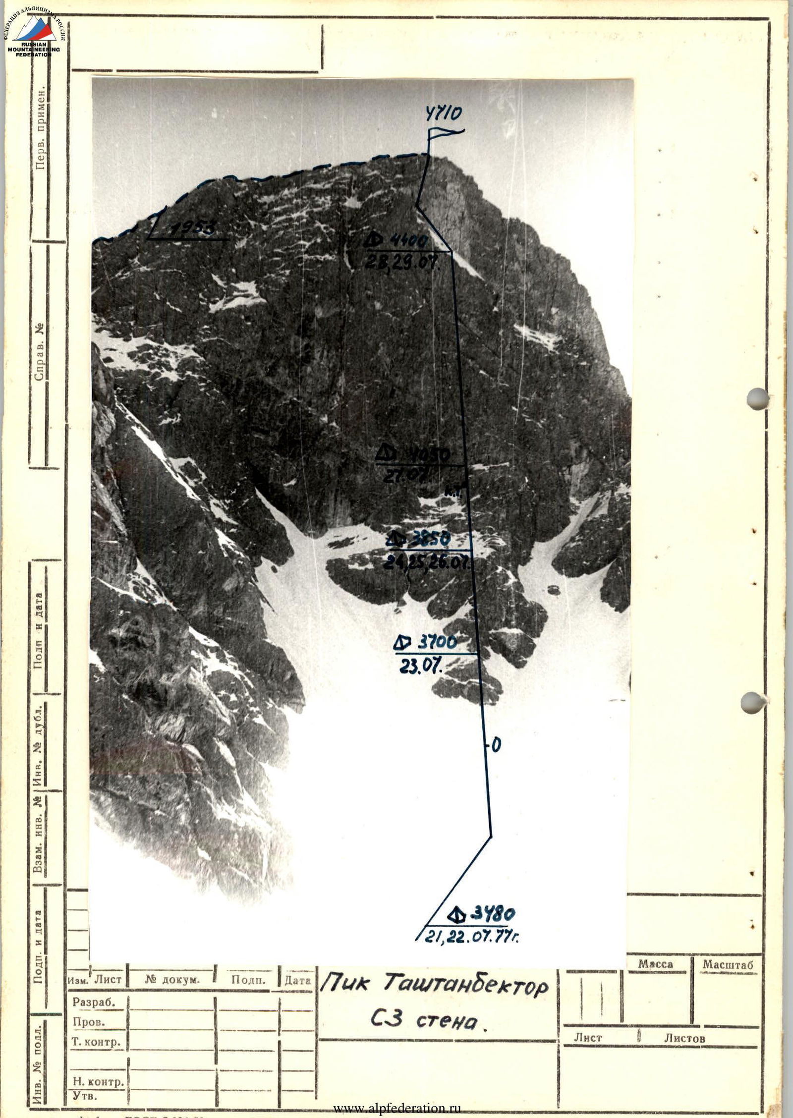
The northwest wall of Peak Tashtanbek-Tor is a kilometer-long granite slab, vertically rising from the foot to the summit. The slab structure of the rocks alternates here with rocks like “ram's foreheads”, inclined platforms, crevices, and corners, as a rule, are filled with ice. The wall is exposed to the west-northwest (10–15° to the north from the western direction), so it is in the shade for the first half of the day and begins to be illuminated by the sun only from 13:00.
There are few loose stones on the wall due to its verticality. Only in the upper part, there are more of them, but their falls are not very frequent and mainly occur along the ice couloirs to the left and right of the route.
Profile of the lower part of the NW wall. Photo by V. Gladchenko — from the NW ridge (on descent).
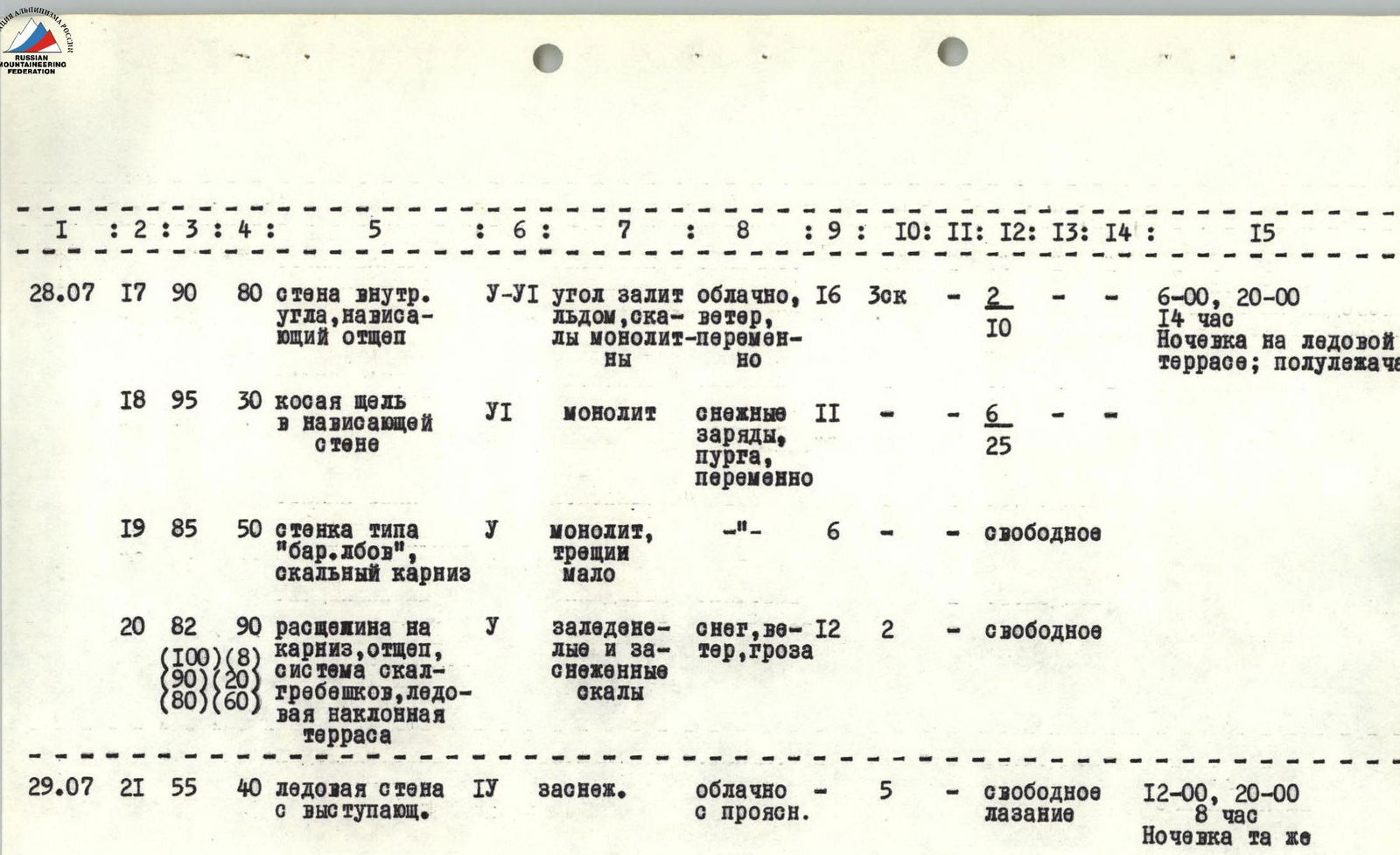
Table of Main Characteristics
- Ascent route: Peak Tashtanbek, northwest wall


| Date | № R | Length (m) | Height (m) | Characteristics of the section | Category of difficulty | Condition | Weather conditions | Pitons: rock | Pitons: ice | Pitons: bolts | Passage: ladders | Passage: pendulum | Climbing hours | Camping conditions |
|---|---|---|---|---|---|---|---|---|---|---|---|---|---|---|
| 1977 | ||||||||||||||
| 22.07 | R1 | 80 | 15 | Ice-firn wall, bergschrund | TU-U | Snowy, bridges weak | Cloudy, wind | 2 | 4 | 7:00–11:00, normal camping on the glacier | ||||
| R2 | 45 | 50 | Ice ascent, rock slabs | IV | Firn crust | Thunderstorm, snow | 2 | 4 | 1 | On crampons | ||||
| 23.07 | R3 | 85 | 25 | Rock slabs, internal angle with a plug | У-U I | Icy | Clear | 4 | 2 | 0 | 11 | 6:00–17:00, camping at the base of the 2nd tower; hanging | ||
| R4 | 70 | 65 | Rocks like “ram's foreheads” | У | Wet | High clouds | 6 | 2 | 1 | Free climbing | ||||
| R5 | 45 | 10 | Ice ridge | У | Rockfall | - | 1 | - | - | |||||
| R6 | 90 | 60 | Slightly overhanging internal angle, overhanging wall, slab-like rocks | У I | Waterlogged and icy | Wind, snow grains | 8 | 1 | 6 | 25 | ||||
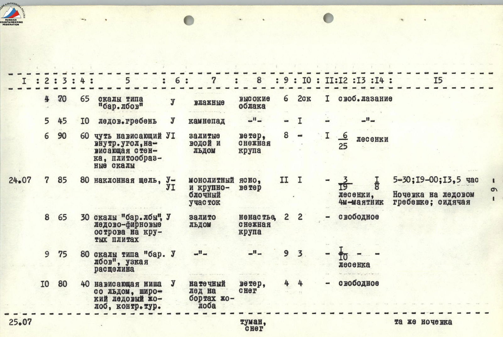
| 24.07 | R7 | 85 | 80 | Inclined crack, monolithic and large-block section | У-U I | Clear | Wind | 11 | 1 | 1 | 3 | 1 | 13.5 | 5:30–19:00, camping on an ice ridge; sitting |
| R8 | 65 | 30 | Rocks “ram's foreheads”, ice-firn islands on steep slabs | У | Icy | Bad weather, snow grains | 2 | 2 | Free | |||||
| R9 | 75 | 80 | Rocks like “ram's foreheads”, narrow crevice | У | - | - | 9 | 3 | 1 | 0 | ||||
| R10 | 80 | 40 | Overhanging niche with ice, wide ice gully, control tour. | У | Ice on the edges of the gully | Wind, snow | 4 | 4 | Free | |||||
| 25.07 | Fog, snow | Same camping | ||||||||||||
| 26.07 | R11 | 90 | 40 | Vertical gully with ice (icicle), rock like “ram's forehead” | VI | Icy, firn crust. Rocks—monolithic, few cracks | Cloudy, wind | 6 | 10 | 5 | 14 | 7:00–21:00, same camping | ||
| R12 | 65 | 70 | Slab, rock belt under the wall | У | Ice with firn on the slab—monolith, almost no cracks | Wind, thunderstorm | 5 | 1 | Free | |||||
| 27.07 | R13 | 92 | 40 | Narrow inclined ledge on an overhanging wall-slab | У I | Monolithic granite, wet | Clear, frost | 2 | 25 | 15 | 14 | 6:00–20:00, camping in hammocks under a ledge on the rock belt | ||
| R14 | 90 | 50 | Wall-slab, narrow ledge | У | - | Clear | 7 | 2 | 1 | 10 | ||||
| R15 | 90 | 40 | Chimney with ice, narrow angle | У-U I | Holds and cracks | - | 8 | 1 | 2 | 30 | ||||
| R16 | 75 | 50 | Slabs, blocky rocks, inclined ice-snow ledge | IV | Rare loose stones | - | 4 | 1 | Free | |||||
| 28.07 | R17 | 90 | 80 | Wall of the internal angle, overhanging fragment | У-U I | Angle icy, rocks monolithic-variable | Cloudy, wind, variable | 16 | 3 | 2 | 10 | 14 | 6:00–20:00, camping on an ice terrace; semi-reclining | |
| R18 | 95 | 30 | Oblique crack in an overhanging wall | VI | Monolith | Snow charges, blizzard, variable | 11 | 6 | 25 | |||||
| R19 | 85 | 50 | Wall like “ram's forehead”, rock overhang | У | Monolith, few cracks | - | 6 | Free | ||||||
| R20 | 82 | 90 | Crevice on the overhang, fragment, system of rock ridges, inclined ice terrace | У | Icy and snow-covered rocks | Snow, wind, thunderstorm | 12 | 2 | Free | |||||
| 29.07 | R21 | 55 | 40 | Ice wall with protruding stones | IV | Snowy | Cloudy with clearances | 5 | Free climbing | 8 | 12:00–20:00, same camping | |||
| R22 | 85 | 40 | Ice gully, embedded stones, protruding rock banks | У | Ice | Cloudy with clearances | 2 | 6 | 6 | 18 | ||||
| R23 | 50 | 80 | Ice wall | IV | Soft firn crust on ice | Clear | 9 | Free | ||||||
| R24 | 75 | 80 | Rock ridge | IV | Monolith, icy | - | 7 | Free | ||||||
| 30.07 | R25 | 85 | 80 | Wall of blocky structure, ice gullies | IV-V | Blocks “cemented” with ice, snow-covered | Clear, frost | 10 | 1 | Free | 15 | 5:30–20:30, camping in the base camp | ||
| R26 | 80 | 80 | Large-blocky and slab-like rocks, pre-summit firn ridge. Summit, Descent | IV | Icy and snow-covered | - | 7 | 2 | Free |
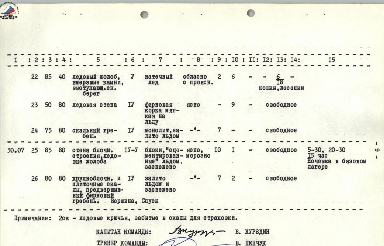
Note: 2 sc — ice screws driven into rocks for belaying.
TEAM CAPTAIN: V. Zhurzdin TEAM COACH: V. Ponchuk
Description of the Route Passage
July 21. At 5:00, the team, along with the observation group, fully prepared, left the base camp in the Tashtanbek-Tor valley and headed to the Kashka-Su valley to the start of the route. At 14:00, they approached the NW wall of Peak Tashtanbek and set up an intermediate assault camp on the Kashka-Su glacier under the wall. The weather was excellent, so until 21:00, they observed the wall and prepared for the next day's ascent to process the beginning of the route.
July 22. At 7:00, the rope team Zhurzdin — Gladchenko started processing the route. 400 m of snow ascent (25–30°) to the bergschrund was done quickly on frozen crust. The lower edge of the bergschrund was almost entirely covered with loose snow that couldn't support a person's weight. It was necessary to descend 2 m into the bergschrund and climb up the wall of its upper edge with the help of pitons and ladders to reach the ice ascent before the rocks (R1). The ice slope to the rocks (500 m, 45°) was overcome in crampons with piton belays (R2). The rocks started with steep granite slabs, partially covered with ice; crampons were not used here. The weather began to deteriorate, and by 11:00, a strong thunderstorm with wind and snow grains broke out. With difficulty, having climbed 10 m of the slab, the leader secured himself in a small internal angle but couldn't wait out the bad weather, so, having fixed the rope, the rope team returned to the tents and arrived back at 14:00. By 16:00, the bad weather had passed, but the loose and wet snow stopped them from further processing the route.
They decided to ascend again the next morning to:
- have one rope team continue processing;
- have the second rope team pull up the backpacks to the possible camping site along the processed path.
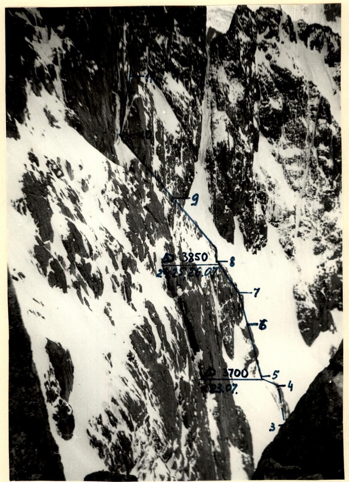
July 23. At 6:00, the rope team Zhurzdin — Podymov ascended to the route, and the second rope team dismantled the camp and headed to the start after 20 minutes. Having climbed up the previously hung rope through the bergschrund and the ice wall, the rope team secured the backpacks on rock pitons and began further ascent. The route went vertically up a granite slab and after 8 m turned into a steep internal angle. Climbing was complex, with a bolt piton driven into very hard rock at the bottom (R3), and with the help of ladders and two auxiliary pitons (artificial holds), they first overcame the slab and then the internal angle. Climbing was complicated by very cold rocks. The internal angle ended with a slab-like overhanging ledge (R4), which was bypassed on the left with ladders, and they reached the beginning of rocks like “ram's foreheads” (R4), having a steepness of about 70° and ending after 65 m with a steep (40–45°) ice ridge connecting the first rock tower to the second. Here, they organized the pulling of backpacks and set up the first hanging bivouac at the base of the second tower, but this was after the first rope team had passed a very difficult part of the second tower (R6), and the bad weather that started at 17:00 forced the team to stop. The second tower began with a vertical, slightly overhanging internal angle, turning into a 5-meter overhanging section (100°), which was overcome with ladders and artificial holds. The next 40 m of the tower were steep (up to 80°) slab-like rocks ending with a narrow inclined ledge. Here, driving the third bolt piton on the route, they broke the first bolt. Looking ahead, it is noted that all three bolts taken were broken on the hard rocks of the summit. Under the overhanging 5-meter slab, the belayer (Podymov) was forced to release the first climber, standing and securing himself on ladders. The weather deteriorated again, snow grains stung their faces, so, having secured the rope on the inclined ledge, they descended to the base of the tower, where the second rope team arrived with the backpacks. On a narrow ledge at the base of the tower, two people could sit, and for the other two, they decided to hang a hammock, which they managed to do with some effort. Those sitting on the ledge managed to have a hot dinner.
July 24. The sky above them was clear in the morning, but an cloud front was visible from the direction of Issyk-Kul. Therefore, they had an early rise, breakfast, and by 5:30, the first rope team ascended to continue working and find a more suitable bivouac before the bad weather.
They passed the previously hung rope to the inclined ledge. Here, an intermediate point was organized for pulling up the backpacks. From here, the route went slightly left and up a crack, bypassing an overhanging “awning” (R7).
After 15 m, when the “awning” remained on the right and slightly below:
- The leader made a 4-meter pendulum to reach it;
- Then, along the vertical edge of the internal angle (30 m), they reached a section of large-block rocks (20 m).
The tower ended with an 8-meter slab, which was climbed only with the help of a bolt piton driven into its upper part and ladders (R7).
Almost 8 hours were spent overcoming the 80 m of the tower, but now the beginning of ice-firn islands among the rocks like “ram's foreheads” promised a more convenient bivouac than the previous one.
From here, the route went left and up towards the base of a large vertical crevice on the wall. The backpacks were pulled up here, and on R8, 30 m higher, on a small ice ridge, they decided to clear a platform for a tent. The weather deteriorated again. Since there was barely enough space on the ridge for one person to work, they decided to leave two people to clear the platform, and the second rope team continued processing the route. Along rocks like “ram's foreheads”, often covered with ice, the rope team Zhurzdin — Podymov went left and up towards the wall-slab to the base of the crevice. A vertical 10-meter internal angle was climbed along its left edge with ladders, and from there, towards a niche under the overhang (R9). From here, having secured the rope, the leader descended, and Ponchuk ascended instead. The overhang was bypassed to the left into an ice couloir (more like a wide gully), along which they climbed 40 m up and to the right, directly to the base of the wall-slab along rocks like “ram's foreheads” (R10). Here, at the base of the vertical crevice, a control cairn was left on a piton. Now, as the snow intensified (19:00), the rope team descended to the “platform”, which consisted of two steps since the ice ridge rested on an inclined rock. Even such a semi-reclining bivouac (two people sitting, two lying down) with a secured tent seemed like a luxury to them, frozen and exhausted.
July 25. It snowed all night but stopped during the day. The fog was so thick that visibility was no more than 6–8 m. It was not fog, actually, but clouds covering them. Naturally, working on the wall in such conditions was impossible. They had to wait.
July 26. The snow had clogged all the ledges and corners — everything they could hold onto. But the wall as a whole was black. From around 3:30 in the morning, the wind that had picked up began to disperse the clouds. At 7:00, the first rope team (Zhurzdin — Podymov) started further processing of the route. The wall was very cold in the morning, their feet were freezing, and the wind was hindering them.
They passed the previously hung ropes to the control cairn. The second rope team prepared the backpacks to start moving and pull them up to the new bivouac site upon the signal from the first team.
From the control cairn, after a short discussion on the spot, they decided to ascend not directly up the crevice (this was dangerous due to falling ice fragments, small stones, and avalanches caused by falling snow), but to the right — up a vertical ice gully filled with ice (like a hanging icicle).
The ice was hard and wavy, like a real icicle, splitting off in lenses, going up as if from there, from a height of 15 meters, suddenly frozen falling water. The width of the gully was 2 m, the depth was about 0.5 m, which allowed them to drive 2 ice screws for artificial holds. First, along the left edge of the gully, having hung 2 ladders, they managed to climb 10 m and drive a good rock piton, using which, they made a 6-meter pendulum to a small ledge on the right edge.
Now, along the “ram's foreheads” on the right edge — straight up (20 m, 85°) parallel to the gully. The already difficult climbing was complicated by an ice-snow crust covering all holds, ledges, and cracks, of which there were very few. They cleared 2–3 m of rock from the crust, and everything was “slick”, no cracks... This work made their hands freeze strongly, and they could warm them only by taking turns putting them in their mouths.
Finally, they reached the source of the gully (R11) — an inclined (65°, 10 m) slab, onto which water flowed from the wall and then into the gully. The slab encircled the granite slab of the wall for 60 meters, rising to the summit.
Now, the path was clear; it was observed from below: parallel to the crevice, along the wall — straight to the summit. Here, on a tiny ledge for one person's feet, they could organize the pulling of backpacks.
Now, they needed to climb 10 m up the slab to the wall and then to the right — almost without gaining height — 60 m to a large ledge on the rock belt (R12). The slab under the ice crust had no cracks, making the ascent extremely difficult, especially psychologically.
The granite wall was almost entirely covered with water and ice flows, making crampons unsuitable here.
Processing the 60-meter belt to the large ledge took place under again deteriorating weather (from 14:00): a thunderstorm with snow grains. By this time, the second rope team had pulled up two backpacks with things that could be left here for the night without much harm to them.
Under the ledge, they planned a site to hang hammocks for the next bivouac. But the thunderstorm and lack of daylight (18:30) did not allow them to do this today, so they returned to the tent at 21:00.
July 27. Early rise, breakfast, and at 6:00, they began ascending the previously hung ropes. The clear, frosty morning promised excellent weather for the whole day. The task of the first was to check the quality of the previously driven pitons and clear the rope from the ice that had formed, so the first rope team's movement was cautious and slightly slow. The rope was largely covered with ice.
From the large ledge, where the rope team ascended (R12), the route went slightly left and up along a narrow (half a foot wide) ledge on an overhanging (95°) wall-monolith (R13). The surface character of the wall resembled complex Crimean rocks (only cold) with few holds for the front phalanges of fingers. The holds were more suitable for friction than for gripping. Without bolt pitons, it was only safe to proceed with caution (!). The leader moved on a double rope, using ladders. 40 m of the wall were processed in almost 4 hours (R13). Here, on a narrow ledge going to the right and up (50 m) to the base of an ice-filled vertical angle (R14), the second climber (Podymov) was taken in. Now, the task was to reach the angle where the second could be taken in, having previously hung 2 ladders for him. The angle with ice resembled a 1.5-meter chimney, going up 40 m (R15). The technique of movement along it was chimney-like, with exits to the right, almost overhanging side, in the lower and middle parts, and to the left — at the top. From the angle, along slabs filled with ice (R16, 75°, 50 m), they exited left and up onto an inclined snow-covered ledge, where they could organize the pulling of backpacks. By 20:00, the rope team descended to the ledge on the rock belt, where the second rope team had pulled up the backpacks and hung two hammocks on the designated section of the wall for tonight's bivouac. The ledge reliably protected them from possible rockfall and ice fragments; otherwise, the bivouac was "bird-like".
July 28. At 6:00, they dismantled the “camp”, and the trio Podymov — Ponchuk — Zhurzdin ascended along the previously hung ropes to an oblique ledge to pull up the backpacks. The backpacks were mostly pulled through the air with one transfer at the base of the chimney. The weather began to deteriorate again, with increasing wind and cloudiness. From the oblique ledge, the path went up and slightly to the right, crossing an internal angle into which the chimney had turned, towards a fragment of the wall (R17, 90°, 80 m). From the fragment, straight up, along a wall like a “ram's forehead” (R18, 95°, 30 m, and R19, 85°, 50 m) to an angle under a rock overhang, using ladders (twice) and artificial holds. At 12:00, a thunderstorm hit, with snow charges falling on them in cycles of 40 minutes — snow, 20 minutes — wind without snow. They began pulling the backpacks into the angle, after which they took in the last climber, Gladchenko. Somewhere above the overhanging overhang, there should have been a snow ledge that they had seen from below and planned to organize a bivouac there. From the angle to the overhang, which turned out to be a large split-off slab, they exited left along a crack (10 m, 100°) and then to the right and up (20 m, 90°) onto rocks filled with ice with steep rock outcrops — “trunks” (60 m, 80°). This part of the wall (R20) to the inclined ice terrace was climbed using free climbing. Here, having cleared the ice, they laid out a nearly horizontal platform for a tent with stones.
At 19:50, they pulled up the fourth participant following the backpacks. Two hours were spent preparing a decent platform and setting up the tent. All this time, a snowstorm continued, with lightning discharges nearby at times. At 22:00, they climbed into the tent in icy storm suits. Their legs hung down from the platform, but they were securely fastened. The bad weather continued throughout the night and the next half-day (until 12:00), and from 15:00 the next day, sunny weather was re-established.
July 29. The bad weather and fatigue of the previous day allowed them to rest. They felt the proximity of the summit. At 12:00, the rope team Podymov — Gladchenko went to process the ice wall-terrace, steeply climbing to the left and up. 40 m to the ice gully were an ice wall with embedded and protruding stones and rocks (R21) with a steepness of up to 50–60°, belayed with ice screws. The ice gully (R22, 85°, 40 m) was overcome with ladders and ice screws, after which an ice wall (50–55°) began, covered with a thin firn crust (R23, 80 m). The wall led to the base of a steep rock ridge, with rocks partially filled with ice and covered with wet snow (R24, 75°, 80 m). Climbing was complex but free. At 20:00, having secured the rope, Podymov began descending to Gladchenko, and an hour later, they returned to the tent, pleased with the processing, to a hot dinner.
July 30. Despite the strong cold, the day was clear, so they had an early rise (at 4:00), and by 5:30, the first rope team Zhurzdin — Podymov began ascending along the processed route. On the section of the ice gully, the backpacks were pulled up; the other sections were climbed with backpacks. The first climber was extremely light, with a backpack weighing about 7–8 kg. But even this had to be removed when climbing the pre-summit section of the wall (R25, 85°, 80 m), representing a steep, barrel-like structure with islands of ice and firn. It was very cold, and their feet and hands froze badly. It was visible 100–120 m to the summit; they were heading straight for it (20 m to the left). On the last section to the pre-summit ridge (R26, 80°, 80 m), climbing became somewhat easier, and all participants climbed with backpacks. The 25-meter pre-summit snow-ice ridge presented no great technical difficulty, and at 11:30, they reached the summit of Peak Tashtanbek! This was apparently the 3rd ascent to the summit after Elchibekov's group (4A category difficulty) and a group led by Ivanchin, who had made a first ascent of the opposite wall (6B category difficulty) two days earlier. They photographed the panorama of the mountains, rested, and at 12:30, began their descent through Peak Onduuchoku (Elchibekov's route) and then down the NE slopes to the Tashtanbek glacier. At 20:00, the team returned to the base camp, where they were met by members of the rescue team led by G. Starikov and other members of the gathering free from ascents.