
Report №104
Report
on the ascent to the summit of Tashtambektor-bashi (4710 m) via the right buttress of the North-East wall.
Team composition:
- Team leader: IVANCHIN I.A. — Candidate Master of Sports
- Participants: RYABOV N.A. — 1st sports category, MAKHNOVICH L.A. — Candidate Master of Sports, STRIKICA N.I. — Candidate Master of Sports
- Coach: PENCHUK V.L. — Master of Sports of the USSR
— 1977 —
Geographical description and sporting characteristics of the Tashtambektor gorge area
The object of the gathering of the Moscow Regional Council of the "Zenit" Sports Society in 1977 was the Terskey-Alatau ridge (Eastern Tien Shan). The Terskey-Alatau ridge is latitudinal and located south of Lake Issyk-Kul, within the territory of the Kirghiz SSR.
The Tashtambektor gorge, which flows into the Turgen Ak-Suu gorge near the snow-avalanche station "Chon-Ashu" (Kok-Kiya settlement), from which a road steeply rises to the Chon-Ashu pass in the Sary-Jaz gorge, is located 50 km east of the city of Przhevalsk.
The area of operation was chosen based on photographs taken from Peak Jigit, which clearly showed the Western wall of Peak Tashtambektor-bashi. Additionally, during the May holidays of that year, a reconnaissance of the area was organized, and the gathering leadership already had a clear understanding of the area.
From classified routes, we knew that there was only one 4A category route, passed by the Marechek group in 1948, to Peak Tashtambektor-bashi via Ondouu-choku, but we still had to find the peak Ondouu-choku, as it was not marked on our maps.
The climate in the area is very unstable, with a large number of overcast days and significant precipitation. This is due to the proximity of Lake Issyk-Kul and prevailing westerly winds. For example, in the city of Przhevalsk, up to 2000 mm of precipitation falls annually, and the Tashtambektor gorge area is even more rainy, as clouds forming over Issyk-Kul have just enough time to fully concentrate.
Good weather lasts no more than 2 consecutive days, and according to local residents, this is the case every year. However, in 1977, the bad weather was exacerbated by cold temperatures, which significantly affected the high-altitude meadows (according to workers of a botanical expedition in the Turgen Ak-Suu gorge, the grasses had only risen by one-third that year).
The Tashtambektor gorge gently rises from the Turgen Ak-Suu gorge and has juniper thickets only in the very lower part, while in the upper part, where the base camp was located, there was only a small amount of grass.
It takes about 30 minutes to walk from the base camp to the glacier. Although the heights of the peaks in the area are relatively low, their glaciation is significant due to the high amount of precipitation. The climate is harsh. At night, there are typically severe frosts, and during bad weather:
- blizzards
- winds reach significant strength.
Preparation for the ascent
Team members began preparing for the upcoming 1977 sports season in the fall of 1976, conducting regular training 3-4 times a week and participating in competitions organized by:
- The Regional Council of the "Zenit" Sports Society
- The Moscow City Alpine Federation.
Transportation of participants and expedition cargo from the city of Frunze to the snow-avalanche station "Chon-Ashu" was carried out by automobile transport. Further, cargo was delivered to the base camp:
- by horse;
- by the gathering participants over 2 days, which contributed to better acclimatization of the participants.
The path upwards took about 2 hours with a load along the trail, which gently rises along the left bank of the Tashtambektor River from the confluence with the Turgen Ak-Suu River.
All team members prior to this ascent:
- completed training sessions,
- made training ascents,
- participant L. Makhnovich had already made a first ascent to the summit of Sherkhan South with a 5B category difficulty.
In addition to training objectives, the tasks of the team members prior to this ascent included:
- reconnaissance of the snow-ice situation,
- observation of the route's condition to choose possible bivouac locations,
- direct acquaintance with the climatic features of the given area.
The task was facilitated by the fact that a significant part of the route was clearly visible from the base camp.
Organization of the ascent
Considering the characteristics and condition of the routes in the area, we took the following group climbing equipment:
- "Pamirka" tent — 1 piece
- Main ropes — 2 × 40 m
- Auxiliary rope — 1 × 40 m
- Rock pitons of various modifications — 30 pieces
- Ice pitons of various modifications — 15 pieces
- Carabiners (in addition to personal ones) — 12 pieces
- Two-step ladders — 2 pieces
- Climbing harnesses for ascending on the rope — 4 pieces
- "Vitalka" type radio — 1 piece
- Green and red flares — 5 pieces
The food ration was selected based on the duration of the ascent, as well as participants' preferences, at a rate of 800 g of dry rations per person per day, for 7 days of stay on the route.
Our buttress was clearly visible from the base camp, so for the first days, we did not need a special observation point. After the ascent to the summit, a planned observation point was to be set up on the glacier under Peak Sherkhan for the descent.
The initial return deadline to the base camp was set for July 26 at 14:00. Subsequently, during communication with the base camp, the return deadline was extended.
In accordance with observation results, the entire route was divided into main sections, and locations for planned overnight stays were identified.
The group left the base camp on July 20 at 17:00, moving upstream along the Tashtambektor River's left bank, and within half an hour, at the confluence of streams from under the glaciers flowing from the North and North-East walls of Peak Tashtambektor-bashi, they crossed both streams and reached the glacier under the NE wall of Peak Tashtambektor-bashi.
After crossing from left to right in the flattening part of the glacier, the group approached the base of the North ridge of the peak and stopped for the night (a total of 1 hour and 20 minutes of walking time from the base camp).
Route progression
First day — July 21, 1977. From the overnight stay at 5:30, the group moved along the northern ridge, crossing an avalanche and rockfall-prone slope, and approached the right buttress of the NE wall. The path took about 30 minutes (it is necessary to pass it early in the morning). The weather was excellent, with a slight frost, and the snow held well. Group members linked up already at the overnight stay: Ivanchin — Ryabov, Makhnovich — Strikiica.
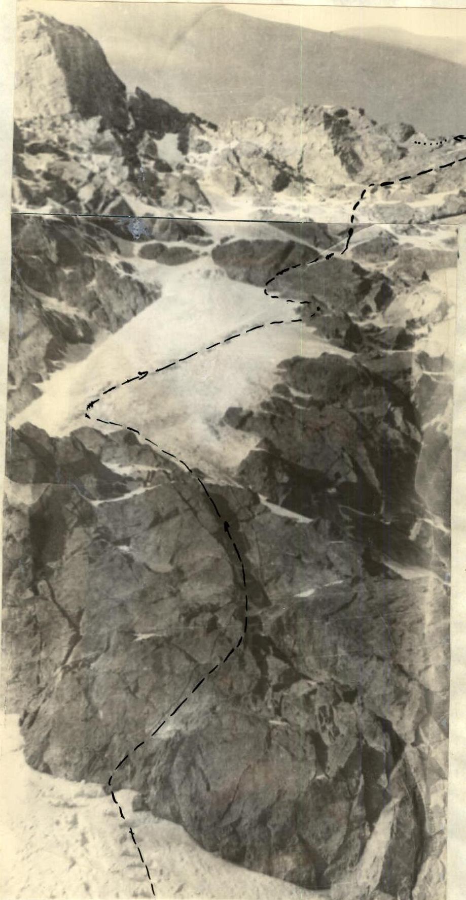
The buttress is a wall in the form of a large triangle in its lower part. The participants named this wall the "Big Triangle." In the middle of the base of this triangle, the participants chose the most expedient path upwards.
On the section R0–R1:
- Rocks of medium difficulty and medium steepness.
- The group proceeds cautiously.
- Constantly observes the "Big Triangle" wall.
- Assesses its rockfall hazard.
However, concerns were unfounded: practically no rocks fell during the passage of the wall and further on the buttress. After 40 m, there is an exit to a small rock ledge.
On the first day, the first rope team led by Ryabov worked ahead. Then, to the left along the ice forehead (section R1–R2), after 2 ropes, there is an exit to another ledge, with alternate belaying and using ice pitons.
From the ledge, 80 m (section R2–R3) — rocks of medium difficulty — lead to a wall, with a gap visible below it on the left, which bypasses the wall on the left.
The path then lay through the gap under the vertical wall (section R3–R4) and upwards to the left — with piton belaying, complex climbing, and the leader's backpack remaining mid-wall, although it was significantly lightened beforehand. The third participant (Ivanchin) used the second rope team's slings to pull the backpack up to the leader. This method of movement was used several times that day.
In the second rope team:
- Makhnovich led,
- Strikiica removed pitons.
It is worth noting that three group members had repeatedly climbed 5B category routes together, so they understood each other with half a word, and the group worked cohesively.
After the wall, the group reached a diagonal shelf (section R4–R5), which bypassed the upper part of the wall and led to debris-covered ledges, from which a large section of the "Big Triangle" wall was visible. The wall was:
- close to vertical,
- but with large cracks.
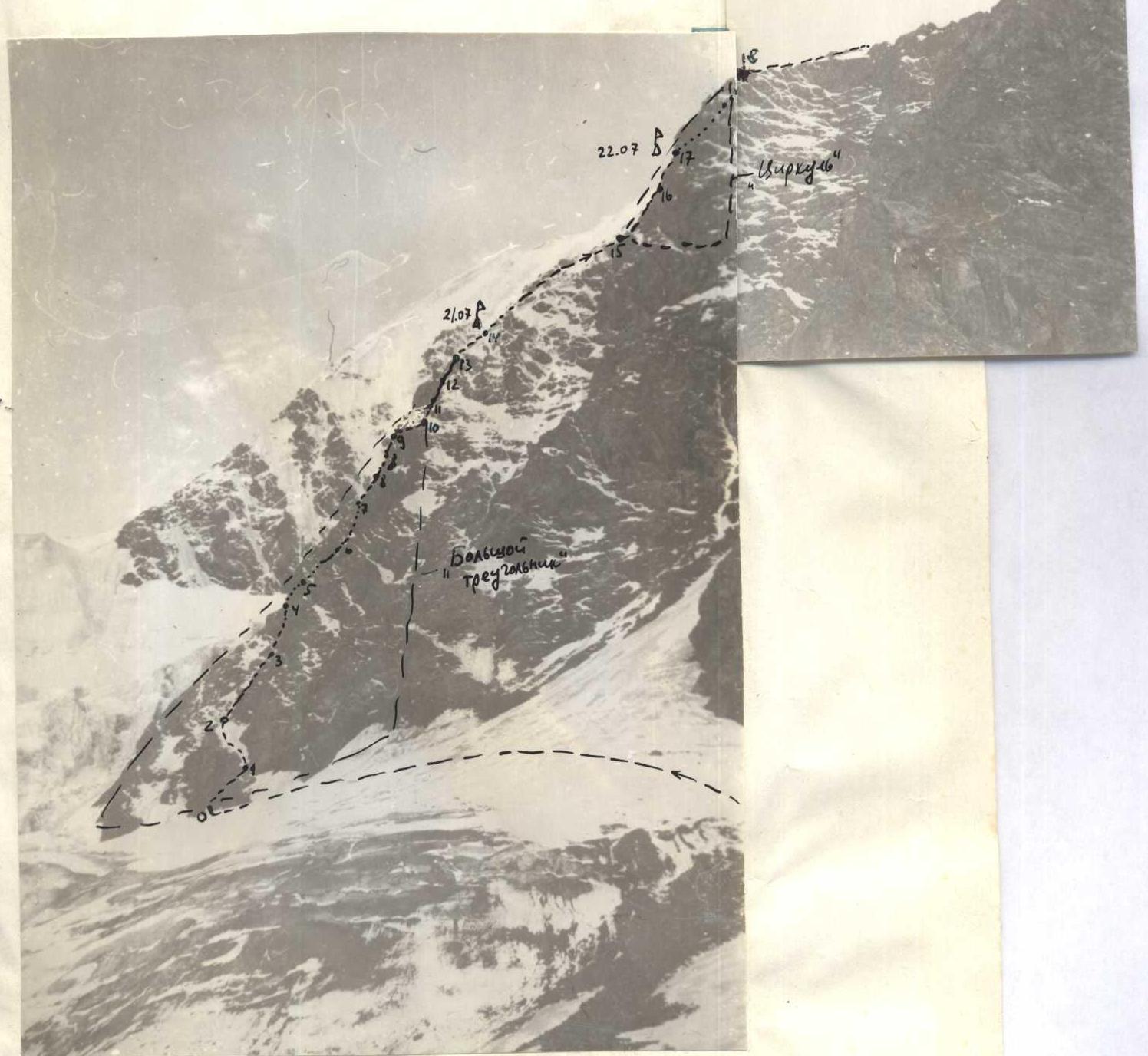
Directly through the center of the triangle, after 2 ropes (section R5–R6), the group approached the steepest part of the wall. Here, to the right and left, non-explicitly defined gullies lead upwards, through which water flows from the remaining ice and snow on the wall.
The group decided to move:
- directly through the center of the triangle,
- as movement through the gullies was complicated by rime ice,
- while the wall had large cracks, facilitating movement and belaying.
After another rope of complex climbing, the group approached a snow-ice gully (section R6–R7), which led to a small ledge on the left side of the "Big Triangle." The gully was very steep, with steps cut into the ice, and piton belaying from the gully walls.
Another rope of steep and sharp rocky ridge (section R7–R8) led to a ledge. From this ledge, the further path up the wall was visible.
The rocks were monolithic, with insignificant handholds, and climbing was very complex (section R8–R9), with the leader's backpack left behind again. Ice pitons were used in the rocks. This section, spanning 2 ropes, took a lot of time and effort, with many pitons hammered (11 pieces).
On section R9–R10, along a shelf crossing the "Big Triangle" wall horizontally, the group traversed to the right lateral side of the triangle, i.e., to the right ridge of the buttress.
From this point, a steep ridge began, but the path did not become easier, as the rocks on the ridge were heavily smoothed and iced, interspersed with sections of rime ice. On section R10–R11, there were 20 m of steep ice ridge and another 20 m of smooth slab. The leader's backpack was pulled up.
On section R11–R12, initially, there was a vertical deflecting wall (5 m), followed by a steep slab-like ridge with practically no handholds, resulting in:
- a large number of pitons,
- and again, the leader's backpack was pulled up.
On section R12–R13, the smooth, iced ridge was passed by the leader with several attempts and using driven pitons as artificial support points, with his backpack pulled up again.
Section R13–R14 was straightforward, with easy climbing and an exit to a snowy ledge, which is the summit of the "Big Triangle" and suitable for an overnight stay. Part of the ridge was cleared, many pitons were hammered into the rocks, and the tent was secured, with participants also belayed inside due to the sharp ridge and steep slopes on both sides of the buttress.
The weather on this day was favorable, and the group worked until 20:00. They fell asleep in complete darkness.
Second day — July 22, 1977. In the morning, the weather began to deteriorate. Ahead, a sharp ridge with a slight ascent was visible, followed by another wall in the form of a triangle, but smaller in size, named "Compass" due to its resemblance to a real compass. The ridge abutted the left side of "Compass." Small ledges and gaps were visible, but there was no clear path to the summit of "Compass." The upper part of the wall was sheer and even overhanging. However, in the middle, a ledge was visible, allowing for a possible bypass of the upper part of "Compass" on the left. To the left of "Compass," a snow-ice gully under the NE wall of the peak was clearly visible, which:
- led to the North ridge of the peak,
- descent into it and further movement were complex,
- the path through the gully was not safe.
On section R14–R15, initially, the ridge was of medium difficulty, then very sharp with walls. After 3 ropes, they approached the foot of "Compass." The new rope team, Makhnovich — Strikiica, with Makhnovich leading, moved ahead. Bad weather set in, with rain mixed with sleet, complicating movement along the wall.
Section R15–R16 consisted initially of a 50° wall and another 20 m at 80°, leading to a small ledge. Many pitons were hammered.
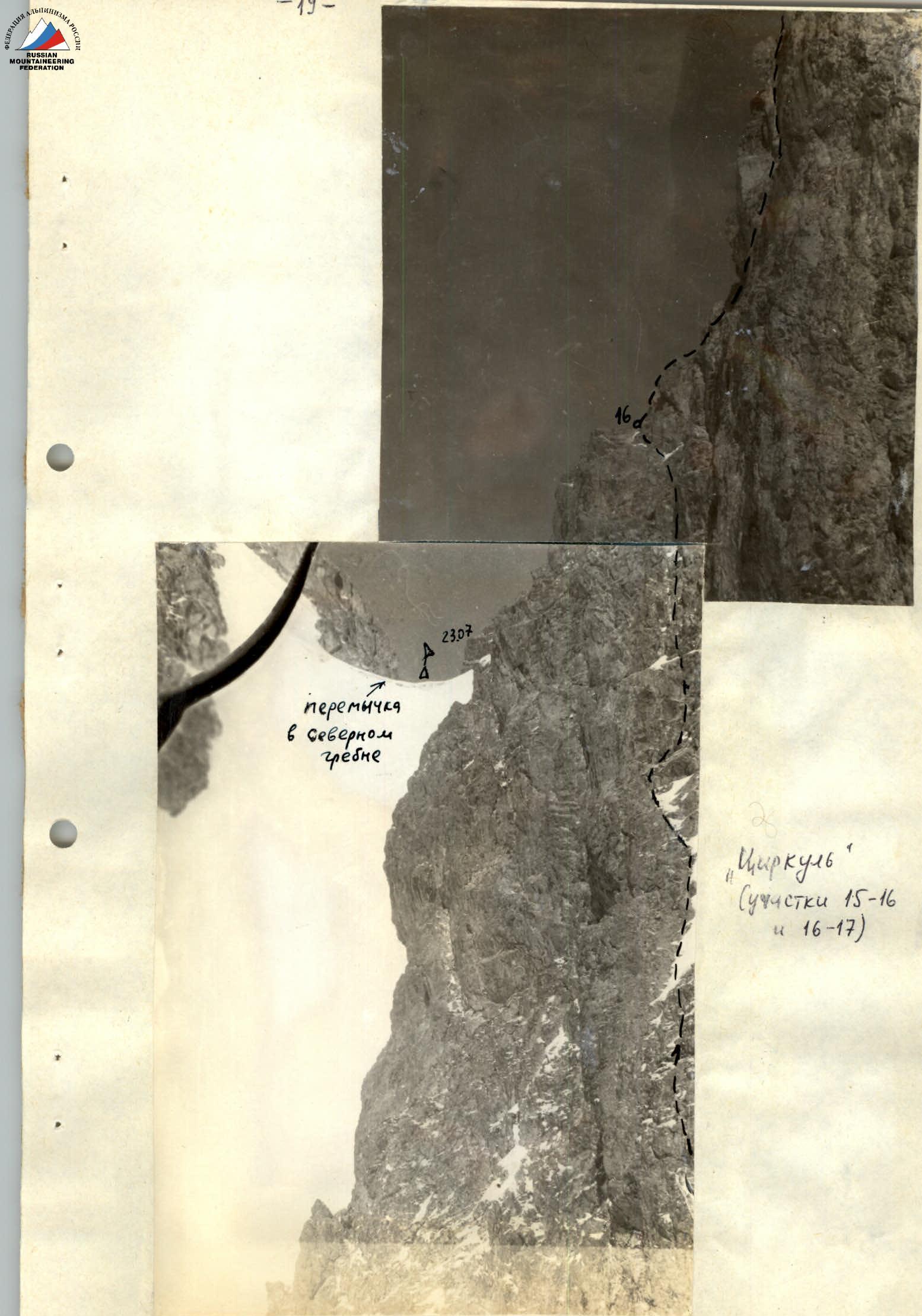
The path then became vertical (section R16–R17), about 20 m, with a large number of pitons hammered, exacerbated by bad weather. A thunderstorm began, and after this wall, they reached a large debris-covered ledge, where they immediately started building a platform for the tent, as further movement in such weather was impractical. By 16:00, a good platform for the tent was constructed. During a brief lull, the further path was examined to bypass the upper part of "Compass" on the left. The tent was secured and belayed with a rope. A control cairn was established here (midway up the "Compass" wall).
Third day — July 23, 1977. The group set out at 7:30 along a very destroyed ledge (5 m), moving left upwards under the uppermost, steepest part of the "Compass" wall with an overhang, entering a very steep rock-ice gully-chimney and exiting onto a col above the "Compass" wall. This rope (section R17–R18) took over 2 hours to overcome with great difficulty.
On section R18–R19, movement was along a ridge of medium complexity, interspersed with sheer but short (2-6 m) walls. The general direction of movement was to the left of the ridge, bypassing walls and pinnacles, some of which were overcome head-on. Here, the ascent on the buttress ended with an exit to the North ridge. To the left, a large gap in the ridge was visible, with a pinnacle in the center, named "Big Tooth."
Section R19–R20 involved descending in a sporting manner into the gap before "Big Tooth." Climbing "Big Tooth" was not straightforward, so they decided to bypass it on the left, although they understood that photos from it of the further path would have been useful.
Section R20–R21 involved:
- descending by snow to the left rocky part of the "Big Tooth" pinnacle,
- bypassing it along an inclined slab to the col,
- rising in the North ridge.
The col in the North ridge was a deep and wide gap, with steep snow-ice gullies descending from it to the west and east. This was a good spot for an overnight stay, with a small lake under the ice. Again, bad weather with a thunderstorm. After setting up the tent and the weather subsiding, Ryabov fixed one rope on a steep rock-ice section. Steps were cut into the ice during the passage. Overnight stay.
Fourth day — July 24, 1977.
The Ivanchin — Ryabov rope team moved ahead. Ivanchin led for the first time. From the gap, they exited to the ridge along a very complex, vertical ice wall with rocky outcrops (section R21–R22). The first 30 m were at 55°, the next 40 m at 80°, and the last 10 m at 90°. A large number of rock and ice pitons were hammered. This was the most complex, key section of the route. It would be advisable to prepare this section in advance from the overnight stay. Bad weather resumed. Snow squalls with strong westerly winds followed one another. The wind was so strong that they had to wait it out, as the leader was literally torn from the slope.
Section R22–R23, after exiting to the ridge, was also an ice wall with rocky outcrops, but less steep than the previous section. However, overcoming these 150 m required a lot of effort in bad weather conditions. After reaching a large snowy shoulder on the ridge, the weather improved, but the wind remained very strong, so the group did not risk setting up an overnight stay directly on the snow. The overnight stay was built on a rocky ridge before the shoulder, but the platform was very small, semi-reclined, yet the tent and participants were reliably secured.
Fifth day — July 25, 1977. Bad weather continued, with heavy snowfall, minimal visibility, strong winds, and the group decided to take a rest day. In such weather conditions, passing the steep snow-ice section before the summit was considered unsafe.
Sixth day — July 26, 1977. Section R23–R24. Movement along the snowy shoulder of the ridge, on the right part, below the line of cornices breaking off, which significantly overhang the NE wall, proceeded with alternate belaying through ice axes.
Section R24–R25 was the pre-summit ice dome, overcome by the leader on the front teeth of crampons. On each rope, 4 hooks were hammered (screwed in).
After completing this section and exiting to the final, almost horizontal ridge (section R25–R26), the weather deteriorated again. The group left all equipment on the ridge and waited out a severe thunderstorm below the slope for about 2 hours. Around 15:00, the group reached the summit and, after a long search, found a note left by the Elchibekov group in 1953, which had ascended via the route of the first ascender, Marechek (via Ondouu-choku).
On the same day, the group descended to the NW ridge of the summit (5 rappels and sporting descents) and spent the night on the first col in the NW ridge extending from the summit.
Seventh and eighth days — July 27 and 28, 1977. Dense cloud cover prevented observation of the descent path from the NW ridge to the right or left, so the group continued straight along the NW ridge to Peak Sherkhan, after which they descended to the glacier Kashka-Suu via a very straightforward path, then bypassed the Sherkhan massif and Peak Tas-Tuya, and, passing through 2 relatively straightforward passes, descended to the base camp.
Overall assessment of the participants' actions
All team members were physically well-prepared. During training ascents, athletes underwent:
- technical training,
- altitude training,
- psychological training,
which helped maintain their working capacity and a sufficient pace of ascent during prolonged stay at altitude.
The team thoroughly prepared for the ascent: studied the route, conducted preliminary observations of the route's condition, was adequately equipped with technical gear and food supplies, which contributed to maintaining a sporting spirit and the success of the entire ascent. On the route, the group acted confidently and technically competently.
Conclusion
Three group members — Ivanchin, Makhnovich, and Strikiica — had repeatedly climbed 5B category routes together, such as:
- Dykh-Tau via the S counterfort,
- traverse of Peak Moskovskaya Pravda,
- traverse of Jigit-Karakolsky,
- Peak Kommunisticheskoy Akademii as part of the Union Championship,
and had 6-7 ascents of 5B category in their records. Ryabov was on his second 5B category ascent and held the 1st sports category in rock climbing. Nonetheless, this ascent made a very strong impression on all group members — it was even more challenging than the aforementioned routes and undoubtedly corresponds to the 5B category.
Even in good weather, one should count on 5-6 days of complex work. Special attention should be paid to:
- unstable weather in the Tashtambektor-bashi peak area,
- a large number of thunderstorm rains,
- frequent strong westerly winds with blizzards and frosts at altitudes above 4000 m.
Therefore, subsequent groups should pay special attention to having:
- warm clothing,
- protection from wet clothing and footwear,
- timely organization of bivouacs.
Team leader I. Ivanchin Team members L. Makhnovich, N. Ryabov, N. Strikiica
Table of main route characteristics
| Date | Section | Steepness | Length (m) | Terrain character | Difficulty | Condition | Weather | Rock | Ice | Step | Time / Notes |
|---|---|---|---|---|---|---|---|---|---|---|---|
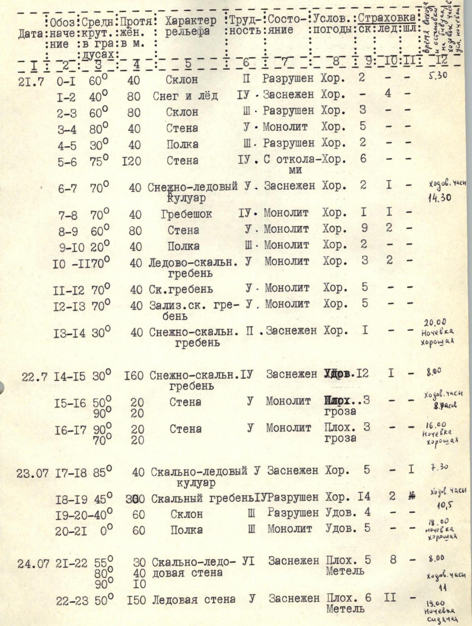
| July 21, 1977 | R0–R1 | 60° | 40 | Slope | 2 | Destroyed | Good | 2 | – | – | 5:30 |
| R1–R2 | 40° | 80 | Snow and ice | 4 | Snow-covered | Good | 4 | – | – | ||
| R2–R3 | 60° | 80 | Slope | 3 | Destroyed | Good | 3 | – | – | ||
| R3–R4 | 80° | 40 | Wall | 5 | Monolithic | Good | 5 | – | – | ||
| R4–R5 | 30° | 40 | Ledge | 3 | Destroyed | Good | 2 | – | – | ||
| R5–R6 | 75° | 120 | Wall | 4 | With cracks | Good | 6 | – | – | ||
| R6–R7 | 70° | 40 | Snow-ice gully | 5 | Snow-covered | Good | 2 | 1 | – | Travel time: 14:30 | |
| R7–R8 | 70° | 40 | Ridge | 4 | Monolithic | Good | 1 | 1 | – | ||
| R8–R9 | 60° | 80 | Wall | 5 | Monolithic | Good | 9 | 2 | – | ||
| R9–R10 | 20° | 40 | Ledge | 3 | Monolithic | Good | 2 | – | – | ||
| R10–R11 | 70° | 40 | Ice-rock ridge | 5 | Monolithic | Good | 3 | 2 | – | ||
| R11–R12 | 70° | 40 | Rocky ridge | 5 | Monolithic | Good | 5 | – | – | ||
| R12–R13 | 70° | 40 | Smoothed rocky ridge | 5 | Monolithic | Good | 5 | – | – | ||
| R13–R14 | 30° | 40 | Snow-rock ridge | 2 | Snow-covered | Good | 1 | – | – | 20:00, Good overnight stay | |
| July 22, 1977 | R14–R15 | 30° | 160 | Snow-rock ridge | 4 | Snow-covered | Fair | 12 | 1 | – | 8:00 |
| R15–R16 | 50°/90° | 20 | Wall | 5 | Monolithic | Thunderstorm | 3 | – | – | Travel time: 8 hours | |
| R16–R17 | 90°/70° | 20 | Wall | 5 | Monolithic | Bad, thunderstorm | 3 | – | – | 16:00, Good overnight stay | |
| July 23, 1977 | R17–R18 | 85° | 40 | Rock-ice gully | 5 | Snow-covered | Good | 5 | – | 1 | 7:30 |
| R18–R19 | 45° | 300 | Rocky ridge | 5 | Destroyed | Good | 14 | 2 | 2 | Travel time: 10 hours 30 minutes | |
| R19–R20 | 40° | 60 | Slope | 3 | Destroyed | Fair | 4 | – | – | ||
| R20–R21 | 0° | 60 | Ledge | 3 | Monolithic | Fair | 5 | – | – | 18:00, Good overnight stay | |
| July 24, 1977 | R21–R22 | 55°/80°/90° | 30/40/10 | Rock-ice wall | 6 | Snow-covered | Bad, blizzard | 5 | 8 | – | 8:00 |
| R22–R23 | 50° | 150 | Ice wall | 5 | Snow-covered | Bad, blizzard | 6 | 11 | – | Travel time: 4 hours, 19:00, Sitting overnight stay | |
| July 26, 1977 | R23–R24 | 30° | 160 | Snowy shoulder | 3 | Firn | Fair | – | – | – | 8:00 |
| R24–R25 | 45° | 140 | Ice dome | 5 | Ice | Fair | – | 14 | – | ||
| R25–R26 | 20° | 200 | Snow-ice ridge | 3 | Snow-covered | Bad, thunderstorm | – | – | – | Descent began: 16:00 | |
| July 27–28, 1977 | Descent | – | – | – | – | – | – | 14 | 8 | – | On descent: good overnight stays, Travel time: 14 hours |
"Big Triangle" (section R5–R6)
Split photo of the lower part of the NE buttress.
— 20 —
Section R21–R22
Comments
Sign in to leave a comment