Ascent Passport
- Ascent category — technical
- Ascent area: Tian Shan range, Teskey Ala-Too.
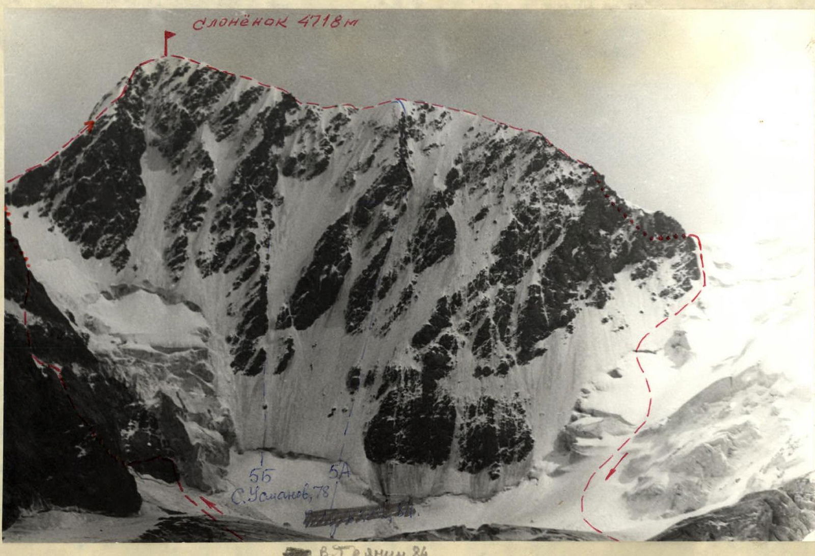
- Slonenok peak, 4718 m, traverse from East to West, 45 km traverse.
- Estimated category of difficulty: 4B (3 with passage).
- Route characteristics: length of sections with 4–5 category of difficulty — 680 m, average steepness of the route — 60°.
- Pitons hammered for belay — 61, of which:
- rock pitons — 28,
- protection gear — 7,
- ice screws — 26.
- Number of climbing hours — 19.
- Number of nights on the route — 1.
- Group composition:
- Filin V.N. 1st category — leader
- Naumov B.E. 1st category — training instructor
- Ostapenko L.A. 1st category
- Sushko S.E. 2nd category
- Pivovarov V.V. 2nd category
- Team coach: Rutkovskaya L.D. (s.r.).
- Date of departure — August 13, return — August 15, 1982.
Main Route Characteristics Table
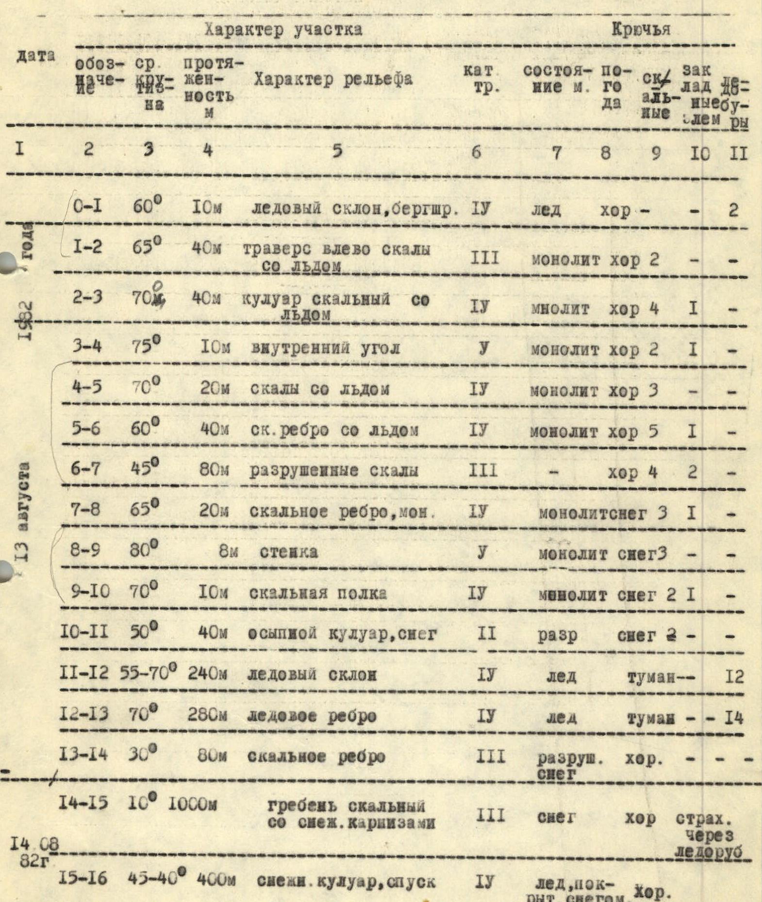
| Date | Designation | Avg. steepness | Length, m | Relief characteristics | Cat. dif. | Condition | Weather | Rock pitons | Protection gear | Ice screws |
|---|---|---|---|---|---|---|---|---|---|---|
| August 13, 1982 | R0–R1 | 60° | 10 | Ice slope, bergschrund | 4 | Ice | Good | – | – | 2 |
| R1–R2 | 65° | 40 | Traverse left, rocks with ice | 3 | Monolith | Good | 2 | – | – | |
| R2–R3 | 70° | 40 | Rocky couloir with ice | 1 | Monolith | Good | 4 | 1 | – | |
| R3–R4 | 75° | 10 | Inner corner | 5 | Monolith | Good | 2 | 1 | – | |
| R4–R5 | 70° | 20 | Rocks with ice | 1 | Monolith | Good | 3 | – | – | |
| R5–R6 | 60° | 40 | Rocky ridge with ice | 1 | Monolith | Good | 5 | 1 | – | |
| R6–R7 | 45° | 80 | Broken rocks | 3 | Good | 4 | 2 | – | ||
| R7–R8 | 65° | 20 | Rocky ridge, monolith | 1 | Monolith, snow | 3 | 1 | – | ||
| R8–R9 | 80° | 8 | Wall | 5 | Monolith, snow | 3 | – | – | ||
| R9–R10 | 70° | 10 | Rocky ledge | 4 | Monolith, snow | 2 | 1 | – | ||
| R10–R11 | 50° | 40 | Scree couloir, snow | 2 | Broken | Snow | 2 | – | – | |
| R11–R12 | 55–70° | 240 | Ice slope | 4 | Ice | Fog | – | – | 12 | |
| R12–R13 | 70° | 280 | Ice ridge | 1 | Ice | Fog | – | – | 14 | |
| R13–R14 | 30° | 80 | Rocky ridge | 3 | Broken, snow | Good | – | – | – | |
| August 14, 1982 | R14–R15 | 10° | 1000 | Rocky ridge with snow cornices | 3 | Snow | Good | Belay via ice axe | – | |
| R15–R16 | 40–45° | 400 | Snow couloir, descent | 1 | Ice, covered with snow, névé | Good | – |
Brief Explanations for the Main Route Characteristics Table
R0–R1. Start of the route — left of the overhanging ice blocks in the snow-ice couloir. Bergschrund is crossed in rope teams. If there is snow, there is a snow bridge.
R1–R2. Parallel to the bergschrund at a height of 10–15 m from the edge of the snow (ice). Move left along the smoothed rocks to the adjacent couloir. Landmark — the boundary between gray and light-brown rocks.
R2–R3. Ascend along the boundary of the above-mentioned rocks up the couloir. Piton belay. Rocks are icy.
R3–R4. Inner corner. In the upper part — chimney jams. Snow and ice complicate the passage.
R4–R5. Sections are overcome with piton belay and rope installation.
R5–R6. Ropes.
R6–R7. Movement with alternating belay. Possible falling of unstable stones.
R7–R8. Rocky ridge is traversed with rope installation.
R8–R9. Wall is overcome in crampons if the rocks are dry.
R9–R10. The exit to the rocky ledge is complicated by water flowing from the crevice.
R10–R11. Exit from the rocks to the main couloir with ice and snow should be done in crampons, i.e., in vibram shoes. There is a risk of falling: there is no possibility to use ice and rock pitons due to the thin layer of ice on the scree.
R11–R12. Ice slope leads to the saddle before the summit. Alternating belay, possible rope installation. The route goes near the rocks on the left.
R12–R13. Summit is reached after simultaneous movement in rope teams. Piton belay.
R13–R14. Cornice ridge.
R14–R15. At the end of the ridge, descend to Metallurg pass.
R15–R16. Descent from Metallurg pass along the ice slope and then along the snow slope. Piton belay.
Sлоненок 4718 m.
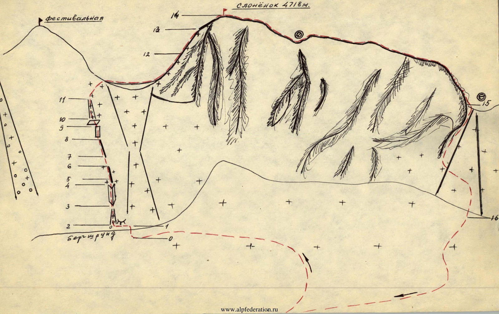
Schematic Route