Ascent Passport
- Ascent class: rock
- Ascent area: Terskey Ala-Too, Tian Shan
- Peak Mendeleevets, 4122, via the "triangle" of the North Face and North Ridge
- Proposed difficulty category: 5B.
- Route characteristics: height difference: 1400 m, length of sections with 5–6 difficulty category — 490 m, average steepness of the wall 74°.
- Number of pitons hammered: rock 61, chocks 37, ice screws 3 (for descent); including 84 for belay and 14 for creating intermediate belay anchors.
- Number of climbing hours: 21.
- Number of bivouacs and their characteristics: one, semi-reclined.
- Team composition: Petrov Andrey Evgenievich, Candidate for Master of Sports, instructor Polyakov Sergey Nikolaevich, 1st sports category
- Team coach: Fyodorov Alexander Sergeevich, Master of Sports, instructor.
- Date of departure on the route: August 17, 1981.
Date of return: August 18, 1981.
The sports club of MIFI conducted mountaineering gatherings from August 1 to 30, 1981, in the "Ala-Too" alpine camp under collective vouchers.
With the aim of mountaineering exploration of the Terskey Ala-Too area, achieving sports categories, and participating in the 1981 Championship of the Central Council of the FIS by mountaineering, the team consisting of: Petrov Andrey Evgenievich — Candidate for Master of Sports, instructor; Polyakov Sergey Nikolaevich — 1st sports category completed the second ascent of the route via the "triangle" of the north face of Peak Mendeleevets, category 5B, on August 17–18.
Our gatherings were held for the first time in the Terskey Ala-Too area. Following the established tradition of making first ascents (previously routes were climbed in the Fann Mountains, Caucasus, and Pamir), we sought new routes.
During a training exit to the Aiu-Ter valley, our attention was drawn to a very steep and extensive wall of triangular shape, which by its north ridge connects to the saddle between Mendeleevets and Uzlovaya peaks.
During our second exit to the bivouac site named "Sказка" (Fairy Tale), we made ascents: — to Peak Karbyshev (category 4B); — the team Petrov—Polyakov ascended Peak Pamyati Blyukhera (category 5B).
The latter route was complicated by heavily snowed-over rocks and bad weather, which well prepared us for a more serious ascent.
At the camp, we learned that the "triangle" had already been climbed on August 13, 1953, by a team from Kuibyshev gatherings, consisting of V. Kalyugin and S. Borodin. The desire to climb this wall did not diminish; on August 16, 1981, we were at the bivouac site under the route.
Description of the Karakol Valley Area
"... We stand on the summit of Peak Gastello... To the east, the ruby triangle of Khan-Tengri glows, the Ak-Suu wall advances towards us in the form of a white trapezoid, Peak Dzhigit stands with black sheer faces, directly to the south is Karakol Peak — the main summit of the Terskey Alatau ridge, and to the west, the delicate ridges of the Dzhety-Oguz wall stretch away...." This is how A. Ryabukhin describes the panorama of the Karakol valley — one of those who pioneered these peaks. ("Conquered Peaks," 1970–1971, p. 77. Peak Dzhigit.) The same view from the same Peak Gastello opened before our eyes, though blurred by bad weather that temporarily settled in. We too came to this land of green slopes dotted with candles of blue Tian Shan spruces, harsh glaciers, and abundant alpine meadows, quiet springs, and roaring waterfalls.
The Terskey Ala-Too area is now well explored, and we too look at these mountains with the hunter's eye because unclimbed routes will always remain as long as there are mountaineers willing to climb them.
The area belongs to the Central Tian Shan, which includes: — large ridges between the Issyk-Kul depression to the north and the Tarim Basin to the south; — a meridional ridge to the east; — western spurs of the Terskey Alatau, Naryntau, Atbashi, and Kokshaaltau ridges to the west.
Tian Shan — the Heavenly Mountains — is a system of parallel ridges stretching almost 1200 km from the vicinity of Tashkent, where the Chatkal Range already reaches a height of 4503 m, to the USSR-China border near Peak Pobeda, 7439 m, the highest in this part of Tian Shan.
Tian Shan ridges, mostly latitudinal: — drop steeply to the steppes of Kazakhstan in the north; — decrease in height towards the extensive and flat Fergana Valley in the west; — descend to the deserts of Central Asia in the east.
The ridges are sometimes separated by wide elevated valleys resembling steppes. In one such valley between the Kungey Alatau and Terskey Alatau chains lies the large Lake Issyk-Kul, with an area of 6206 sq. km and a depth of up to 702 m, its level at a height of 1608 m.
The snow line in Tian Shan rises from 3200–3700 m in the west to 4200 m in the Khan-Tengri area. Tian Shan has intense glaciation — its numerous glaciers reach significant lengths and thicknesses.
Over the Central and Eastern Tian Shan, a climatic front forms at the beginning of summer, making climbing conditions less favorable than in the Pamir. Thunderstorms are frequent; precipitation decreases from July to August, so the second half of summer is considered more favorable for climbing.
It is worth noting that this year the weather was characterized by persistent unfavorable conditions for climbing throughout the season. In July, due to bad weather, about a third of all planned ascents were not carried out. In August, rain (snow at higher altitudes) and accompanying thunderstorms were almost daily phenomena, leading to the early closure of climbing routes due to avalanche danger: — first for Peaks Karakol and Dzhigit; — then for the remaining areas. However, a sharp decrease in spontaneous rockfalls was noted.
The flora and fauna of Tian Shan are diverse. In the northern regions, there are thickets of Tian Shan spruce, and in the foothills, wild apple trees and other deciduous species. In the milder climate of the western regions, there are forests of numerous heat-loving deciduous species, including wild fruit trees (pear, apple, walnut) and shrubs. Subalpine and alpine meadows serve as excellent pastures. As in other mountainous areas, poplar, maple, honeysuckle, aspen, euonymus, sea buckthorn, and Rhodiola rosea grow here.
 There are thickets of juniper and birch; edelweiss can be found both among the meadows and on sheer cliffs. There are many mushrooms.
Among the animals, one can find: — hares; — badgers; — marmots; — ground squirrels; — roe deer; — ibex; — bears; — wolves; — foxes; — snow leopards, and others.
Among the birds: — tits; — woodpeckers; — bullfinches; — black grouse; — alpine choughs; — crows; — snowcocks, and others.
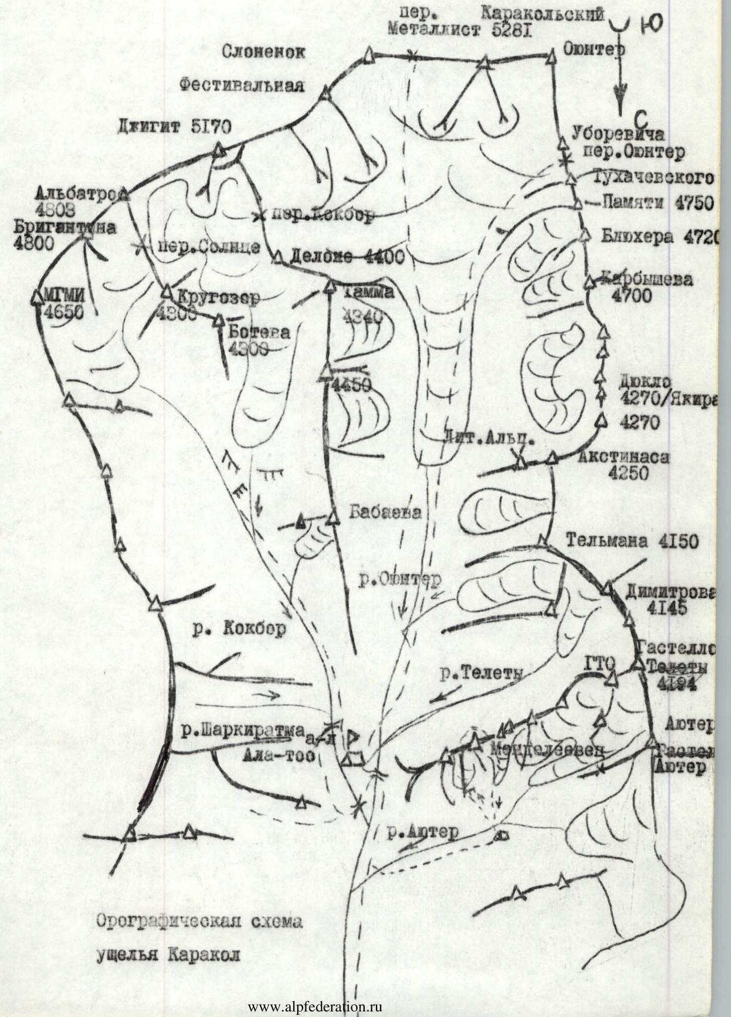
The high Terskey Ala-Too ridge, latitudinal like most Tian Shan ridges, runs directly south of Issyk-Kul. This ridge is characterized by a typical Tian Shan flat shape of heavily glaciated peaks, the highest of which are: — Karakol Peak 5280 m; — Peak Dzhigit 5130 m; — Tashtambe ktorbashi 4716 m; — Gadzhyr 4700 m; — Peak Pamyati Blyukhera 4750 m; — Peak Tukhachevsky 4700 m; — Peak Karbyshev 4720 m, and others.
To the east, Terskey Ala-Too connects with the Sarydzhaz ridge, with main peaks: — Peak Semenov 5816 m; — Bayankol 5790 m; — Peak Kazakhstan.
In mountaineering terms, the Karakol valley has earned a reputation as a training ground for high-altitude climbers due to the strong glaciation of high peaks and changeable, often persistently bad weather. The area is well explored. Based at the "Ala-Too" alpine camp, located in a picturesque meadow with springs among spruces, 20 km from the town of Przhevalsk, numerous ascents to the peaks of the area are made annually.
Nevertheless, the following areas are considered less explored: — the Dzhety-Oguz valley; — areas south of Dzhigit.
The valley and its spurs can be divided into several areas with bivouac sites from which ascents are directly made.
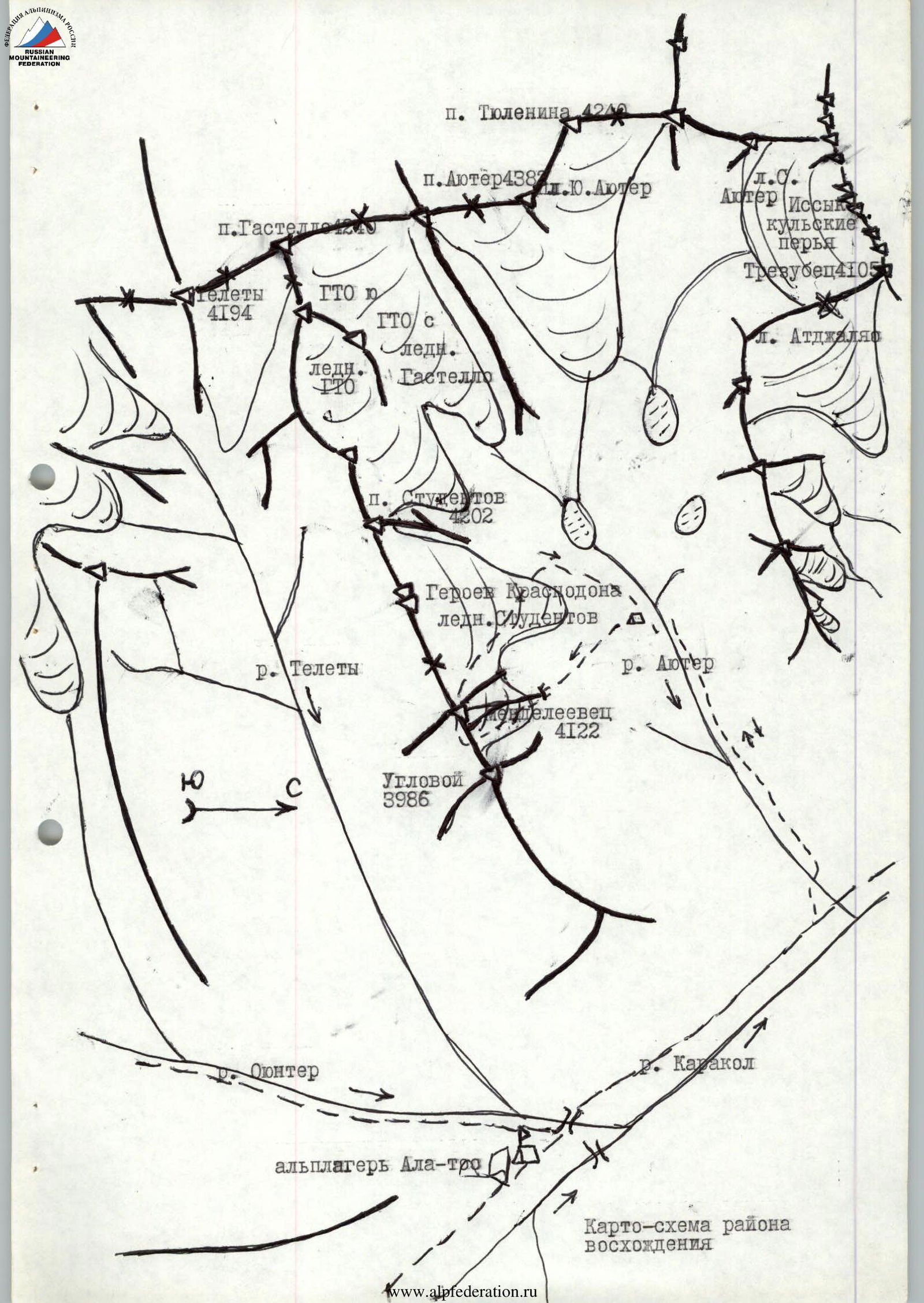
Opposite the camp is the Telety valley with peaks of categories 2A–3B — a training area. The approach from the camp takes 2–3 hours.
Up the valley, to the right, on the moraine above the Karakol glacier — is the "Sказка" (Fairy Tale) bivouac site with grass and a spring (5–6 hours). Ascents: — Peak Litovskikh Alpinistov 3B; — traverse of Djuklo-Akstinas 3A; — Peak Karbyshev 4B, 5A, 5B; — Peak Pamyati Blyukhera 4A, 5A, and 5B; — ascents to Karakol Peak.
On the opposite side of the valley, there are bivouac sites under Peaks Dzhigit and Festivalnaya, from which ascents are made: — Peak Dzhigit 4A, 5B, 5B (credited, A. Ryabukhin's route), and category 6; — traverse Festivalnaya—Slonenok 5B; — Peak Slonenok 5B, etc.
This year, several routes were laid on Festivalnaya and Slonenok, categories 4A–4B, under the guidance of Kudashkin.
Also leading to Dzhigit is the Kok-Bor valley, which goes up from the camp. Here are located beautiful peaks: — Brigantina; — Albatros with routes of categories 4B–5A. From here, routes start to the upper Dzhigit and along the serried North Face 5B.
Down the valley, along the road from the camp, to the left, after 0.5 hours, the Aiu-Ter valley opens — the warmest in this area. Routes here are rock and mixed: — Aiu-Ter 3A, 3B, 4A, 4B, 4B; — Gastello 2A; — Gastello-GTO — 3A; — GTO 2B; — Mendeleevets 2B, 3B; — Issyk-Kulskie Per'ya 4A, 4A; — Grecheskikh Patriotov 3B, etc.
This area is very convenient (approaches take 2–3 hours from the camp) for training ascents and fulfilling category norms, but for a full-day gathering work, there were not enough routes of categories 5A–5B. During training, we made an ascent to Peak Mendeleevets, category 2B, getting to know the peak and the descent route. At the end of August, we also made an attempt to lay a route of category 5A–5B on the east face of Peak Aiu-Ter via Peak Tyulenina, but it was unsuccessful due to weather.
In accordance with the observations made and the description obtained from the first ascenders, a tactical plan for the ascent to Peak Mendeleevets via the "triangle" of the north face was drawn up: — August 16, 1981 (Approach to the bivouac site under the route. Observation and photography.) — August 17, 1981: — 5:30 — Departure from the bivouac site. — 5:30–6:30 — Approach to the route. — 6:30–7:30 — Section R0–R1, R1–R2, communication with the observation camp. — 7:30–8:30 — Passage of the key section R3–R4, R4–R5. — 8:30–9:30 — Sections R5–R6 and R5–R7. — 9:30–11:00 — Passage of key sections R7–R8 and R8–R9. — 11:00–11:30 — Section R9–R10, communication with the camp, snack. — 12:00–13:00 — R10–R12 and key section R11–R12. — 13:00–14:00 — Section R12–R13. — 14:00–15:00 — Section R13–R14. — 15:00–16:30 — Key section R14–R15, control round. — 16:40–17:30 — Ridge section, communication with the camp. — 17:40–19:00 — Section R15–R16, exit to the saddle. — 19:00–20:30 — Ascent to the summit of Peak Mendeleevets. Bivouac in the summit area. — August 18, 1981: — Rise at 6:00. — Descent to the bivouac site on the Aiu-Ter river by 10:30.
Communication times were determined according to the camp's communication schedule.
Observation group: — Fyodorov Alexander Sergeevich, Master of Sports; — Prishchepa Sergey Leonidovich, 1st sports category.
In the tactical plan, we took into account that the passage of the upper part of the route would be done under conditions of daily bad weather, and accordingly, special and bivouac equipment was chosen. However, on this day, snowfall and a snowstorm started 1.5–2 hours earlier than usual, complicating the ascent.
Approach to the bivouac site: from the "Ala-Too" alpine camp, down the valley along the road for half an hour. Then left along the trail, crossing the Aiu-Ter river by a bridge, and further up the valley — a steep ascent in the forest (0.5 hours). Then the trail levels out, exits the forest, and after 0.5–1 hour leads to convenient bivouac sites by the river opposite the "triangle" of the north face.
There is a spring at the bivouac site. From here: — up the valley, a trail goes to the bivouac site by the lake along the Aiu-Ter river; — perpendicular to it, on the other side of the river, a trail rises to the bivouac sites "over the sheep's foreheads," which are clearly visible from the river.
As in other valleys, there is a characteristic "saz" after a steep ascent; the valley opens onto a horizontal section.
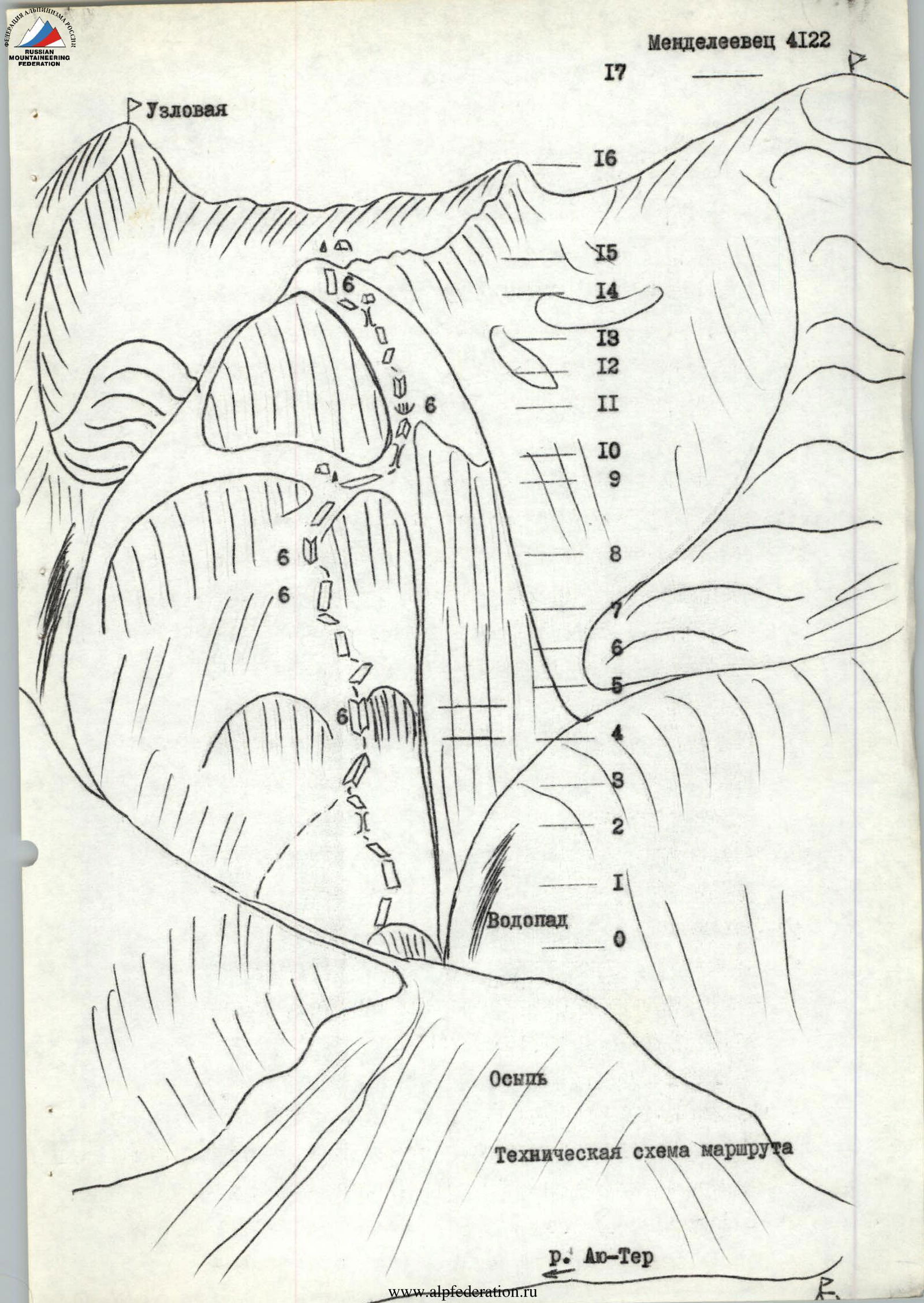
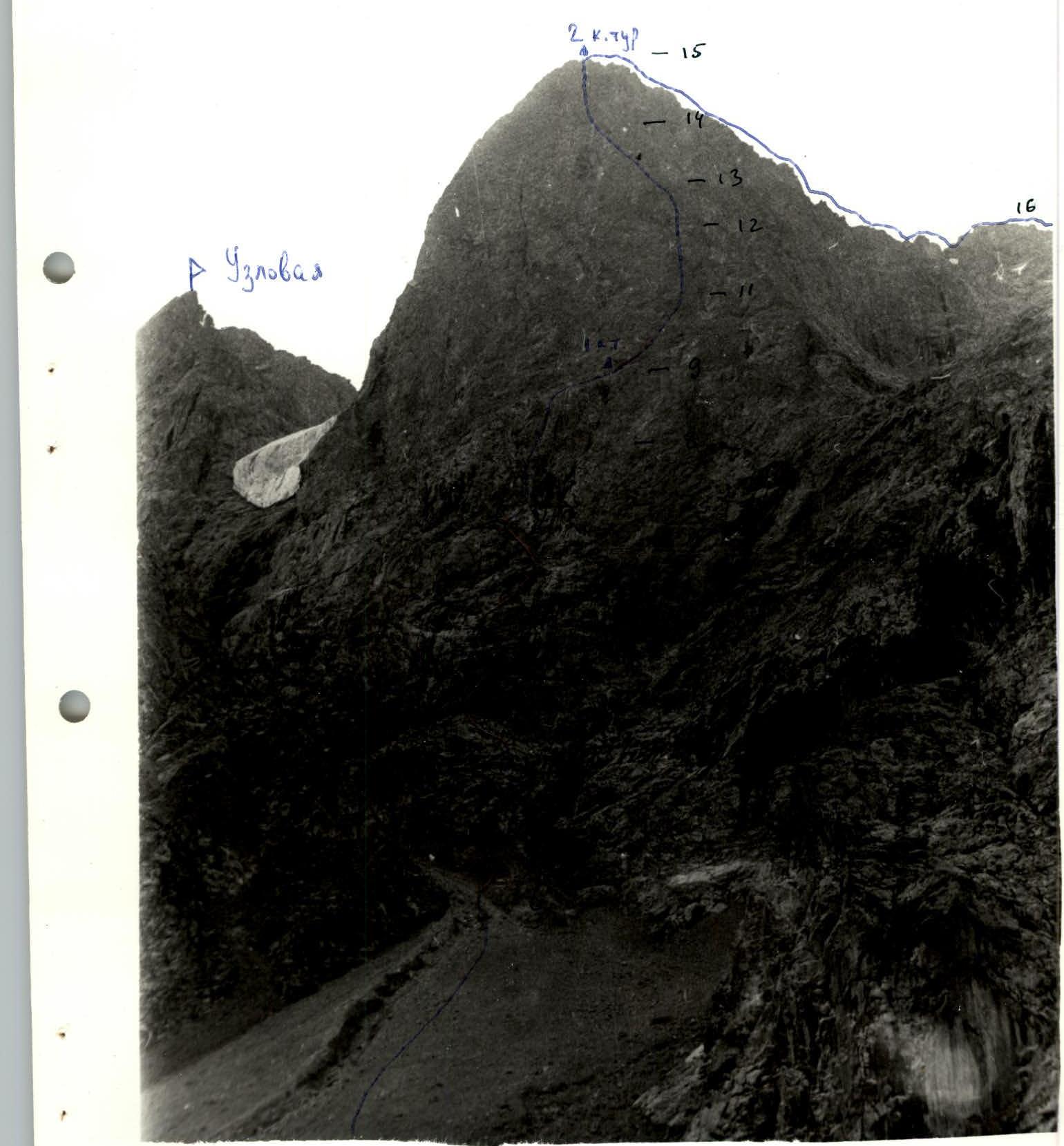 Technical scheme of the route.