Route Description
To the summit of "Lithuanian Climbers" from the east via the wall - Category 4A difficulty:
- A. Petrauskas (leader)
- A. Buiko
- R. Valepetaite
- R. Vosylute
- V. Valatka
- M. Navelukas
Brief Description of the Summit
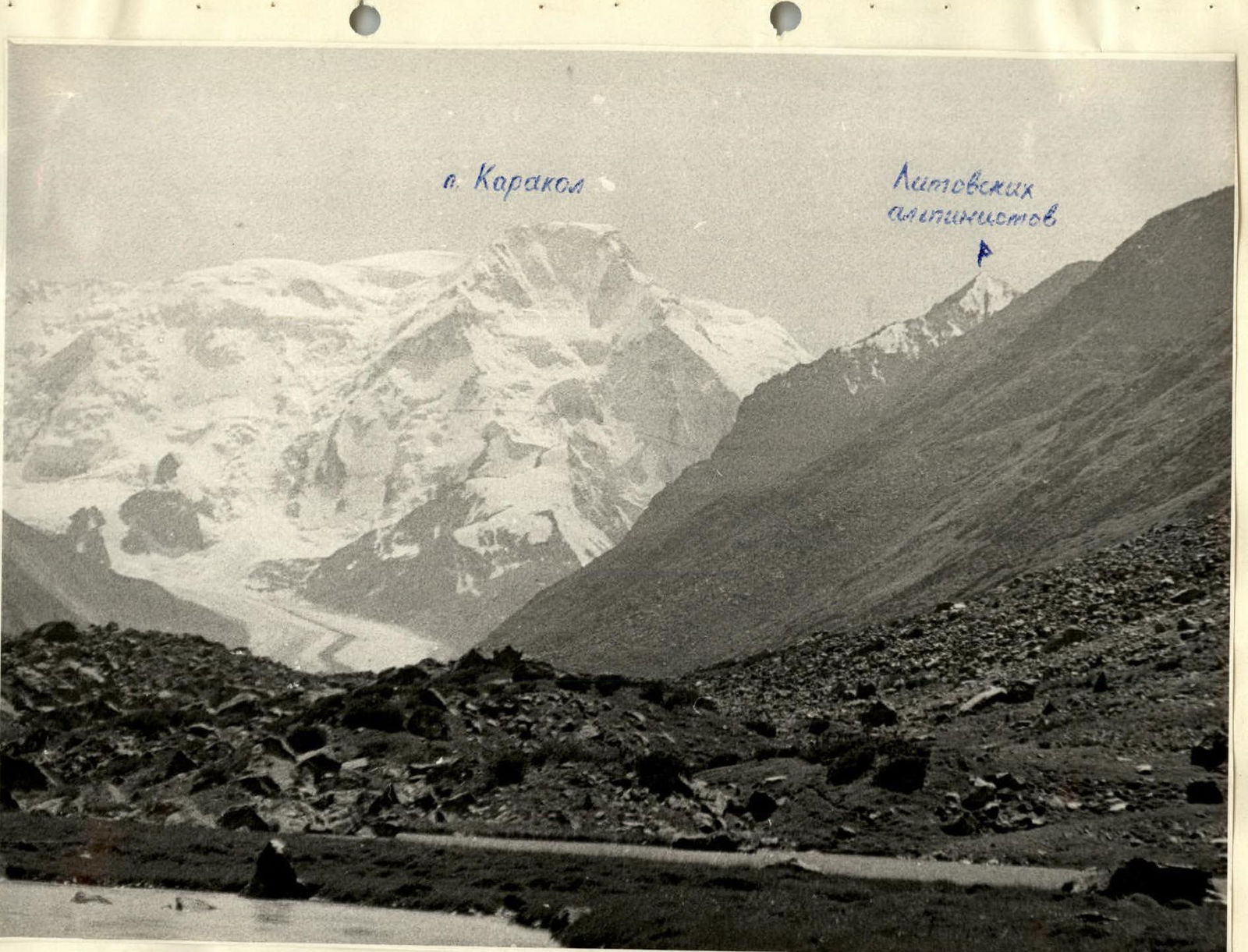
The summit "Lithuanian Climbers" is located in the Teskey Ala-Too ridge, Tian Shan mountain range, in the Karakol gorge. It is situated in the northern spur of the ridge, running through the Jety-Oguz summit and towards Karakol.
The distance from Przhevalsk town to the foot of the "Lithuanian Climbers" summit along the Karakol river gorge is approximately 35 km.
- The eastern slopes of the summit descend into the On-Tor river gorge (where On-Tor and Knol-Tor rivers merge, On-Tor is renamed Karakol) towards the tongue of the On-Tor glacier.
- The northwestern spur, extending from the summit, leads to the "G Akstinas" summit.
- The northern slopes of the summit are largely covered in ice.
- The eastern and southern sides are predominantly rocky with varying structures.
The summit slopes down to the glacier from the south and west. The summit height is 4080 m. The first ascent was made in 1959 from the saddle between "G Akstinas" and "Lithuanian Climbers" summits. The route is classified as Category 2A difficulty. No other routes to the summit have been recorded.
Route Description
I. Approach to the campsite.
From the base camp, located on the right bank of the On-Tor river at its confluence with the Kol-Tor river, ascend along the right orographic bank of the river to a bridge crossing the river (about 40 min). Cross to the left orographic bank and climb a steep ascent to the saz (1 hour). Then, following the slope, the path leads to the tongue of a large scree slope descending from the slope (50 min). The so-called "lower Karakol campsite" is situated on this scree. From this location to the beginning of the flat part of the On-Tor glacier moraine is 40-50 min. A campsite is set up under a large boulder.
- Approach to the start of the route (sections R1 and R2).
Depart from the campsite on August 17, 1953, at 5:00 towards the tongue of the On-Tor glacier. Walk along the large moraine to a stream flowing from the slopes on the right-hand side of the direction of travel. The stream flows through a deep, narrow canyon in the slope. At its confluence with On-Tor, the stream disappears into the scree. Here, turn sharply right and ascend zigzagging directly up the grassy slopes, bypassing protruding "sheep's foreheads" about 150-200 m from the riverbed. The "sheep's foreheads" become more frequent and turn into a rocky ridge.
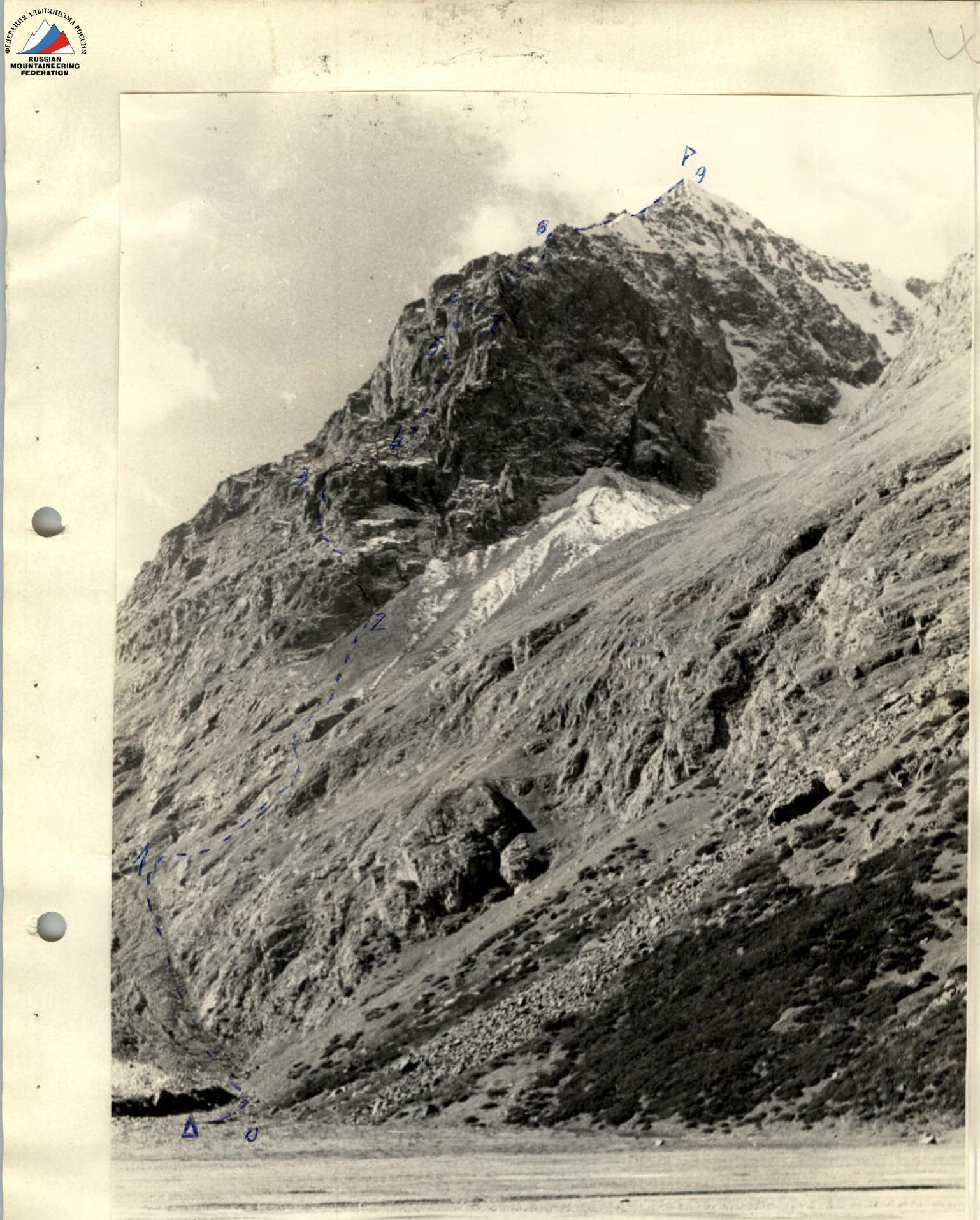
- Approach to the base of the wall (sections R3 and R4, photo 2).
Here, form three pairs. Begin ascending the ridge in a southwest direction. Climbing is of medium and easy difficulty, with some sections on fairly large smooth slabs. The average steepness is 45°–50°, with some steeper sections at 55°–60°. The length is 4-5 ropes. Protection is provided by transverse anchors through protrusions. Upon reaching the ridge, a sport climbing ascent is organized. Two pitons are hammered in. The ridge is sharp. On the other side of the ridge is a couloir, ending in a narrow, steep cleft at its lower part. The ridge ends in "sheep's foreheads" at its base. The couloir leads directly to the base of the wall. It is not recommended to ascend the couloir from the bottom due to the difficulty of the climb and the danger of falling rocks periodically shooting through the lower and middle parts of the couloir. Mountain goats often pass through these areas. From the ridge, without losing height, traverse to the upper part of the couloir and proceed to the base of the wall.
4. The Wall
From the summit, the eastern ridge branches into the southern ridge and the southeastern ridge. To the east, the ridge ends in the eastern wall. To the northeast, the wall turns north, and at the turn, a poorly defined northeastern ridge descends. Under the base of the wall lies a steep slope with couloirs and "sheep's foreheads". See diagram 2.
In the left part of the wall, there is a prominent smooth reddish rock visible even from the campsite. However, to reach the base of this part of the wall, one must cross two more ridges separating couloirs and abutting the wall in a southerly direction. The right part of the wall, through which the route passes, is grey. It features a cleft on its left side (i.e., in the middle of the entire wall), from which a poorly defined buttress descends, separating the grey part of the wall from the reddish part. This cleft resembles an internal corner with smoothed walls in places, and it is not recommended to ascend via this cleft.
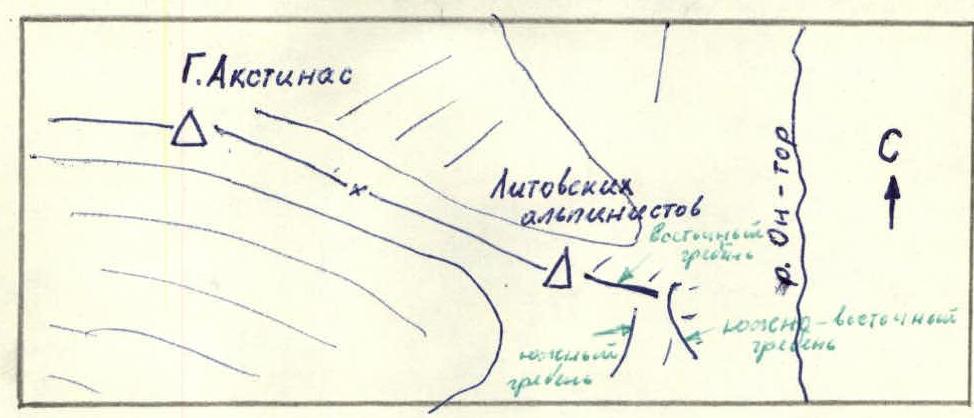
Diagram 2
- Continuation of the wall (section R5, photo 3).
The wall is initially overcome by ascending a depression resembling a very obtuse internal corner, continuing the couloir in a direction upwards to the right. The steepness of the first rope is 40°–50°. After passing the first rope, the corner ends, and one ascends another rope upwards to the left via ledges resembling a ladder. There are no protrusions for protection; intermediate pitons are hammered in. Climbing is of easy to medium difficulty. The average steepness of the slope, which is traversed upwards to the left by the second rope, is 50°–60° (2 pitons). The remaining sections are overcome through sport climbing. The upper platform accommodates no more than 3 people. Protection is provided by pitons (2 pitons). From this platform, the ascent continues directly upwards. The average steepness of the next 20 m is 80°–85°. In the upper part of this section, there is a 1.5-2 m section with a negative angle. Climbing is complex. Protection is piton-based. Three intermediate pitons are hammered in. At the top, there is a narrow green ledge 1 m long. Here, a sport climbing ascent is organized, and two more participants ascend (3 pitons). There are sufficient cracks for piton placement. The green platform is located under the base of the large left cleft, resembling an internal corner with smoothed walls, which separates the wall into grey and reddish parts. Ascending via this cleft is not recommended as it ends in a ceiling at the top. 3 meters to the right of the green ledge is a poorly defined narrow black cleft. Ascending via this cleft and to it is complex. Holds are small and unreliable. The steepness of the cleft is 75°–80°. After ascending about 5 meters, one can exit the cleft to the right onto a protruding corner and ascend to the top of the steep part of the wall. Climbing is complex. Protection is piton-based (4 pitons). At the top, a rope is secured for a sport climbing ascent (1 piton for protection). The average steepness of the protruding corner is 75°–80°. The length of the section from the green platform to the top of the steep part of the wall is 25 m.
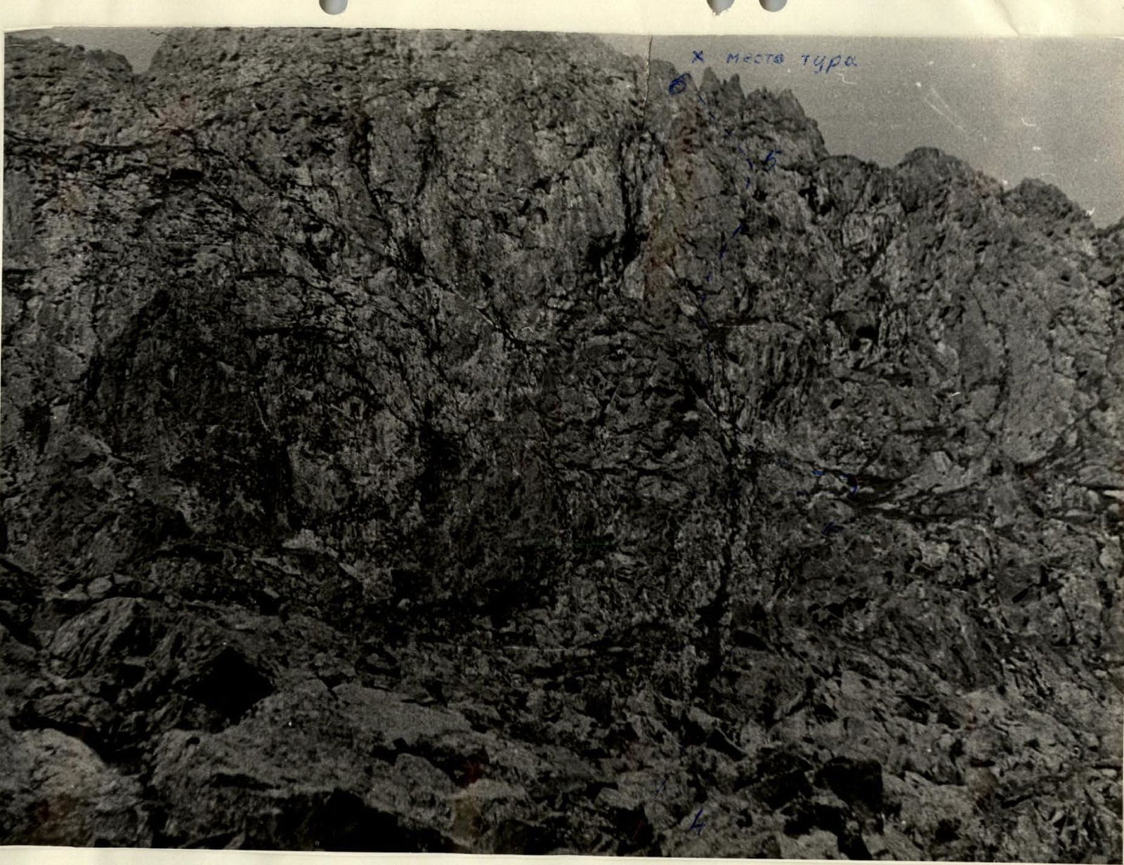
- Exit from the top of the steep part of the wall to the saddle on the ridge (section R6, photo 3).
Following the overcoming of the steep part of the wall, a relatively gentle part of the wall with large ledges covered in earth and vegetation begins. To the saddle on the southeastern ridge, there are 4-5 ropes. The average steepness is 40°–45°. A control cairn is built here. Protection is alternating through protrusions.
- From the saddle to the eastern ridge.
From the saddle, a depression of 2-3 ropes begins (section R7, photo). To the left of the depression is a deep couloir. Descent-climbing is easy; protection is alternating through protrusions. On the northern side of the depression are sheer drops. From the depression, ascend to the junction of the southern ridge with the eastern ridge, then along the eastern ridge for 5-6 ropes (section R8). Ascend along inclined slabs and easy rocks. The average steepness of the ascent is 45°–55°. Many loose rocks! Protection is through protrusions.
- Ascent along the eastern ridge to the summit (section R9, photo 4).
Initially, there is a horizontal part of the eastern ridge 600-700 m long. The ridge is sharp in places. Further, there is an ascent of about 500-600 m with an average steepness of 35°–45°. The rocks are mostly easy. Protection is simultaneous through protrusions. Be cautious; many loose rocks!
9. Descent
The descent begins along the ridge leading to the G. Akstinas summit, to the first couloir on the left (section R10, photo 4), and then down the couloir via medium and small scree to the glacier. In the middle part of the couloir, there is a rocky step about 5 m high. Be cautious! Do not dislodge rocks.
Cross the glacier in the direction of the moraine leading from the summit campsite and the "G Akstinas" summit. From the upper campsite, descend along a marked tourist trail to the tongue of the On-Tor glacier and further to the campsite where the observer groups are located.
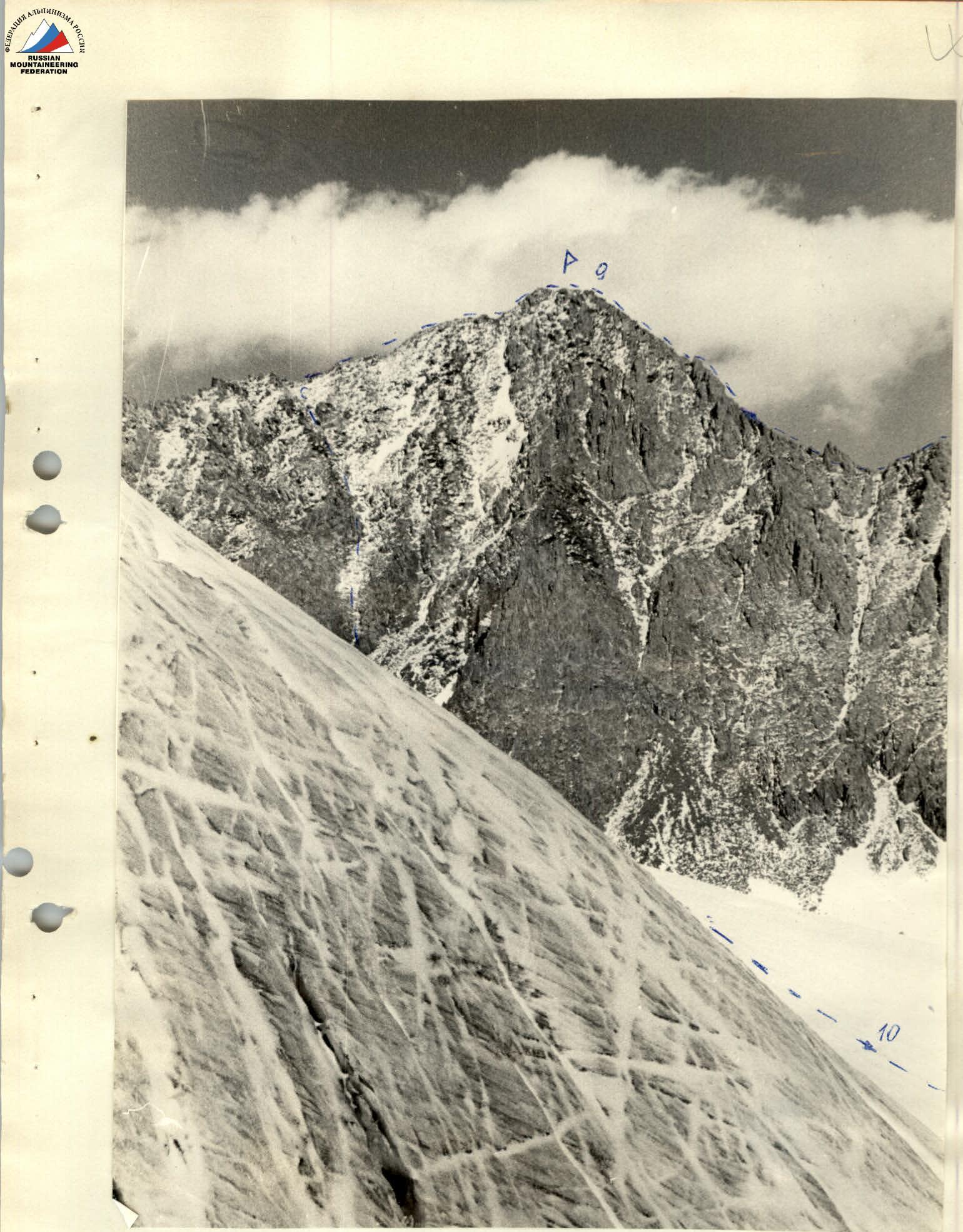
Photo 4


