
- Climbing category — technical.
- Climbing area — Central Tien Shan, ridge, Karakol gorge.
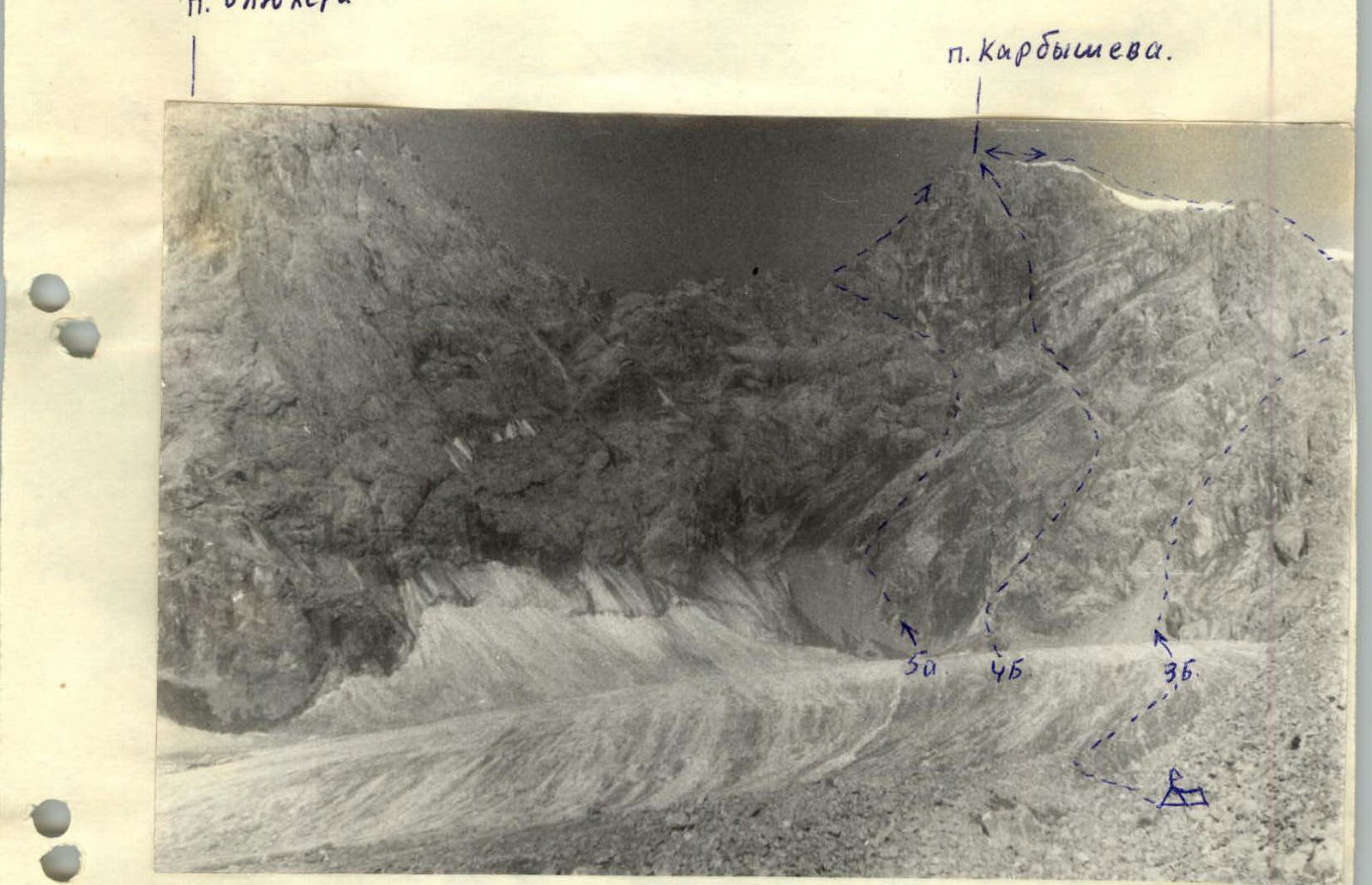
- Peak, its height, climbing route: Peak Karbyshev, 4700 m, via the eastern ridge.
- Estimated difficulty category — 3B.
- Route characteristics: height difference — 780 m, average steepness — 40°.
- Number of pitons for belay: rock pitons — 6 pieces, ice screws were not used for creating intermediate belays.
- Number of climbing hours:
- from the upper base camp under the glacier to the upper campsite — 2 hours.
- from the upper campsite to the couloir — 30 minutes.
- ascent through the couloir — 40 minutes.
- from the control cairn to the summit — 5 hours.
- descent via the ascent route — 1 hour 30 minutes.
- return to the base camp — 1 hour 30 minutes.
Total time — 10 hours.
- Number of campsites and their characteristics: there is a campsite under Peak Karbyshev. The route was completed without overnight stays.
- Surname, name, patronymic of the team leader, participants, and their sports qualification: Serdyukov Ivan Ivanovich 1st sports category — team leader, Nikonov Viktor Petrovich 1st sports category — participant, Belov Sergey Viktorovich 1st sports category — participant, Nemirovsky Yuri Borisovich 1st sports category — participant, Agafonov Gleb Ivanovich 1st sports category — participant, Taran Nikolai Astakhovich 1st sports category — participant
- Team coach — Koreneva Irina Efimovna — Master of Sports
- Date of starting the route and ascent — August 7, 1978.
Route Description
Section R0–R1
At the lower part of the northeastern slope of Peak Karbyshev, there are three distinct talus cones.
From the upper campsite, we proceed along the glacier, keeping to the right-hand side. After 30 minutes, we approach the base of the right cone and begin the ascent. The talus narrows and turns into a couloir. At the top of the couloir, we exit to the right and upwards onto the shoulder of the eastern ridge of Peak Karbyshev via talus shelves.
We build a large control cairn, tie in, and move up the ridge.
Section R1–R2
From the control cairn, we move simultaneously for 5 ropes. The climbing is not complicated, but the ridge is heavily destroyed (Photo 3). We proceed to an internal corner that leads out onto the ridge.
Section R2–R3
We pass the corner with piton belay. The climbing is challenging, with many loose rocks; it is easier because most of the ice in the corner has thawed. Belay: 4 pitons, rock projections (Photos 4–5–6).
Section R3–R4
Further along the ridge, consisting of large blocks (Photo 7), the movement is alternating and simultaneous for the next 3 ropes. We pass the ridge ascent to the right along a shelf to a corner (Photo 8). Behind the corner, there is a challenging traverse along the wall for 4 meters into an internal corner, with 2 pitons and rock projections. The corner leads out onto the ridge (Photos 9–10).
Section R4–R5
Further, a relatively easy ridge with snowfields approaches the main northern slope of the peak. We ascend it via a wet corner (Photo 11) to the left along shelves, alternating. Rock projections. After cutting through a cornice, we exit onto a snowy ridge.
Section R5–R6
Along the snowy, broad ridge, we proceed to the summit. In places, ice is exposed. We put on crampons. We reach the summit. From the upper assault camp to the summit, we spent 5 hours. The descent via the ascent route took 2 hours. We organized two rappels of 20–40 meters.
Recommendations
The route is passable in any weather. When attempting the route early in the season, it is essential to have:
- 2 ice pitons.
The descent from the summit is recommended as the primary and entirely safe option for other routes (4B and 5A) as well.
| Date | Section Designation | Average Steepness in Degrees | Length in Meters | Terrain Characteristics | Difficulty | Condition | Belay (rock/ice pitons) | Weather Conditions |
|---|---|---|---|---|---|---|---|---|
| 8.08.1978 | R0–R1 | 35–40° | 700 | Talus, couloir | II | Loose | - | - |
| R1–R2 | 20–25° | 140 | Destroyed rocks | III | Loose rocks | Simultaneous | ||
| R2–R3 | 55–60° | 40 | Corner, slabs | IV | Rocks, loose rocks | Projections (5 pieces) | ||
| R3–R4 | 25° | 120 | Large blocks | III | Rocks (b.t.) | Alternating, Projections | ||
| R4–R5 | 45° | 400 | Corner, wall, sharp ridge | IV | Rocks, snow | 2. Projections | ||
| R5–R6 | 45° | 500 | Wet corner, snowy ridge | III | Rocks, snow, ice | Alternating, Simultaneous | Good |
Photo 1
Comments
Sign in to leave a comment