Ascent Passport
-
Ascent class — high-altitude and technical
-
Ascent area (№ according to KTMGV) — Terskey Ala-Too, № p/p.
-
Peak, its height, and ascent route — p. Karakolsky, 5281 m, North face (along the "snake").
-
Proposed category of difficulty — 5B
-
Route characteristics: height difference — 1631 m average steepness — 62° (wall) length of sections:
- R1 — 80 m
- R2 — 480 m
- R3 — 340 m
- R4 — 480 m
- R5 — 560 m
- R6 — 120 m.
-
Number of pitons: for belaying, for creating, etc. rock — 115, ice — 78, bolt — 4
-
Number of travel hours — 51 hours
-
Number of nights and their characteristics — 4 (3 semi-reclining, 1 good)
-
Full name of the leader, participants, their sports qualification: leader Bелоусов Vitaly Mikhailovich — CMS, Lebedev Vyacheslav Georgievich — CMS, Shvab Alexander Evgenievich — CMS, Agafonov Gleb Vladimirovich — 1st sports category
-
Team coach: Bелоусов V.M.
-
Date of departure and return: August 1, 1978, August 5, 1978
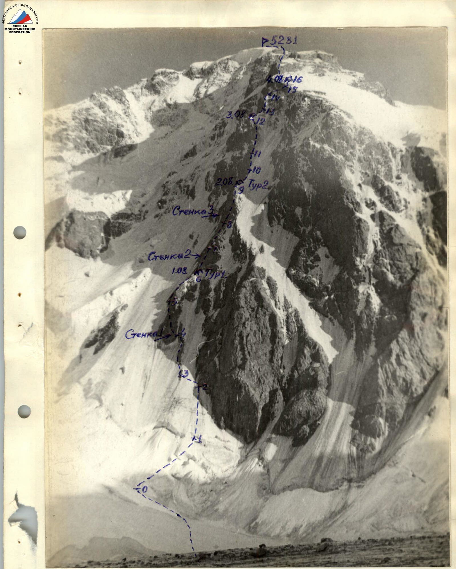
Photo 1. General view of the route.
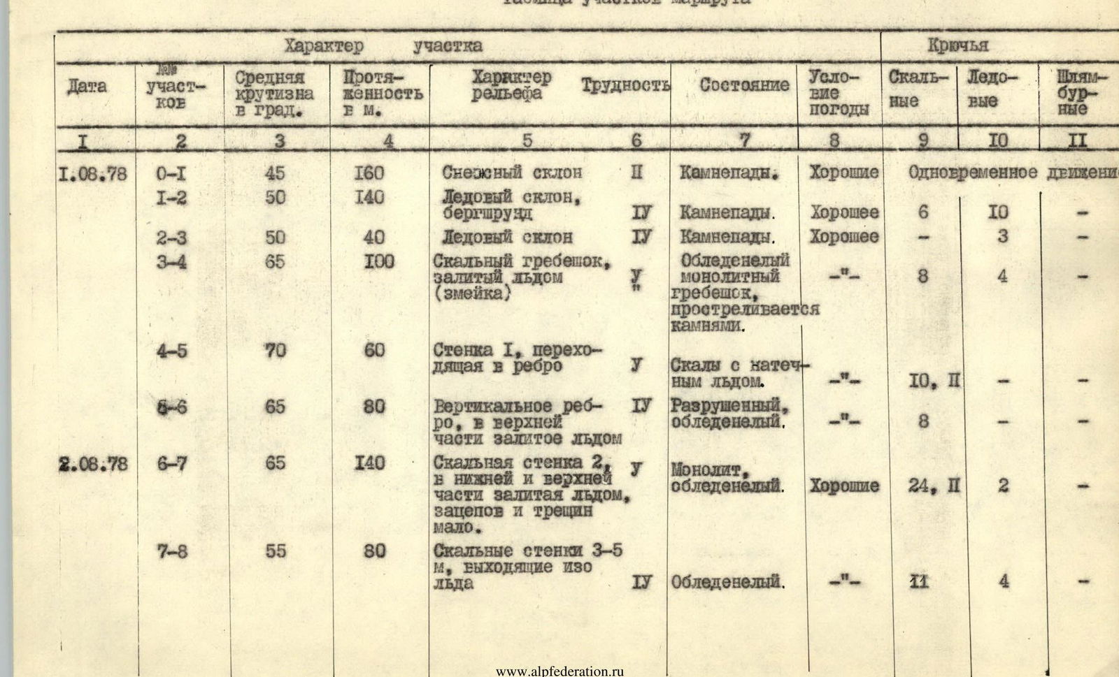
Route Sections Table
| Date | № sections | Average steepness in degrees | Length in meters | Terrain characteristics | Difficulty | Condition | Weather conditions | Pitons: Rock | Pitons: Ice | Pitons: Bolt |
|---|---|---|---|---|---|---|---|---|---|---|
| August 1, 1978 | R0–R1 | 45 | 160 | Snow slope | 1 | Rockfall. | Good | Simultaneous movement | ||
| R1–R2 | 50 | 140 | Ice slope, bergschrund | 4 | Rockfall. | Good | 6 | 10 | — | |
| R2–R3 | 50 | 40 | Ice slope | 4 | Rockfall. | Good | — | 3 | — | |
| R3–R4 | 65 | 100 | Rocky ridge filled with ice ("snake") | 5 | Icy monolithic ridge, exposed to rockfall. | «-» | 8 | 4 | — | |
| R4–R5 | 70 | 60 | Wall 1, turning into a rib | 5 | Rocks with ice accretion. | «-» | 10, 2 | — | — | |
| R5–R6 | 65 | 80 | Vertical rib, filled with ice at the top | 4 | Destroyed, icy. | «-» | 8 | — | — | |
| August 2, 1978 | R6–R7 | 65 | 140 | Rocky wall 2, filled with ice at the bottom and top, few holds and cracks. | 5 | Monolith, icy. | Good | 24, 2 | 2 | — |
| R7–R8 | 55 | 80 | Rocky walls 3–5 m, emerging from ice | 4 | Icy. | «-» | 11 | 4 | — | |
| R8–R9 | 65 | 120 | Rocky wall 3, filled with ice accretion, weakly dissected. Goes along the ice-rock border. | 5 | Icy, many loose rocks | Good | 9 | 12 | — | |
| August 3, 1978 | R9–R10 | 55 | 80 | Rib: rocky on the left, icy on the right | 4 | Ice accretion, rockfall | Cloudy, light snow | 6 | 7 | — |
| R10–R11 | 65 | 80 | Ice slope turning into a rocky wall. | 5 | Ice accretion, rocks monolithic | «-» | 6 | 8 | — | |
| R11–R12 | 65 | 120 | Vertical rocky-icy rib with few holds. | 4 | Monolithic rocks, icy | «-» | 13 | 3 | — | |
| August 4, 1978 | R12–R13 | 50 | 80 | Icy rib | 4 | Monolithic | Cloudy, light snow | — | 5 | — |
| R13–R14 | 67 | 60 | Walls filled with ice. Vertical hanging ice at the top. | 5 | Monoliths with vertical ice accretion covering rocks. | Bad, snowing, wind | 5 | 8 | — | |
| R14–R15 | 60 | 80 | Ice wall with rocky outcrops. | 5, 6 | Steep ice accretion. Rocks covered with ice crust. | «-» | 5 | 12, 3 | ||
| R15–R16 | 30 | 80 | Icy slope with rocks embedded in ice. | 1 | Destroyed, rocks frozen in ice. | Bad, very strong wind, light snow. | Outcrops, simultaneous movement | |||
| August 5, 1978 | R16–R17 | 35 | 240 | Snow ridge with rocky outcrops and small gendarmes. | 2, 3 | Icy rocks, dense snow. | Good | Outcrops, simultaneous movement | ||
| R17–R18 | 30 | 160 | Sharp snow ridge with rocky outcrops. | 2, 3 | Dense snow, rocky outcrops monolithic | «-» | Outcrops, simultaneous movement, ice axe belay. | |||
| R18–R19 | 40 | 140 | Rocky ridge, heavily dissected, small walls. | 3 | Icy, snow-covered | «-» | 4 | Outcrops | ||
| R19–R20 | 30 | 120 | Snow ridge turning into a snow dome. | 2 | Dense snow | «-» | Simultaneous movement |
Descent via the 4B category route on the northeast ridge through the Metallurg pass.
Brief Description of the Route by Sections
August 1, 1978. Section R0–R1
From the very beginning of the route, it is necessary to walk on crampons on a firm snow slope. Starting the route directly from under the "snake", it is necessary to move up to the right, where the bergschrund is closed and easier to pass. Rocks fall from the wall above and to the right of the "snake". It is necessary to carefully pass the icy slope and the "snake" to its upper part.
Section R1–R2
The bergschrund is passed by complex climbing on the ice wall using ice screws and chopping steps and holds. See photo 3. Next is a powerful ice slope, which is climbed on the front teeth of crampons. It is necessary to keep direction under the left part of the powerful rocky wall, ensuring safety from rockfall. The ice is strong and steep. See photo 4.
Section R2–R3
After passing under the rocks of the wall twenty meters up, it is necessary to traverse the slope and exit to the lower part of the rocky "snake". The slope is passed with careful belaying, on crampons using ice screws for belaying and ice axes. The first participant passes the icy sections without a backpack. The passage of the remaining participants is carried out on the rope.
Section R3–R4
It is more convenient to pass the "snake" on the left side. The belaying is piton. The rocks are filled with ice. Climbing is difficult. It is better to move on crampons on the ice accretion, and hold on to and hammer pitons into the rocks.
Section R4–R5
Not reaching the upper edge of the rocky "snake" twenty meters, the route goes to wall 1, which is passed by difficult climbing in Vibram shoes or colo shoes. See photo 6. Backpacks are pulled up. The wall is monolithic, with a small number of cracks and holds. Further, the wall becomes slightly gentler and goes up in the form of a rib.
Section R5–R6
After wall 1, the route goes along a rocky vertical rib. The rocks are composed of large blocks, the cracks are filled with ice. Box-shaped pitons are very good for belaying. The upper part of the rocky rib is filled with ice. Night 1. The site for a sitting bivouac is chopped out in the ice and partially located on a rocky outcrop. The tent is used as a "Zdorка". Here is Tour 1.
August 2, 1978. Section R6–R7
After exiting to the first rocky wall, the route goes straight up along the counterfort, which is periodically interrupted by walls and a steep icy rib. The left part is rocky and drier, the right part is filled with ice. Wall 2 is passed directly by very difficult climbing. The use of ladders is required. The rocks are monolithic. The cracks are mostly filled with ice.
Section R7–R8
After wall 2, the route goes along a steep rocky rib. Short walls are passed by climbing in Vibram shoes. Icy sections require passage in crampons. With the exit to the next wall, crampons are removed and passed by climbing. The rocks are monolithic, but mostly the cracks and holds are filled with ice. It is often necessary to clear holds from ice.
Section R8–R9
The rib turned into wall 3. The rocks are monolithic. Cracks in the ice. It is passed on the right side. See photo 7. The belaying is exclusively piton. The backpack of the leading climber is pulled up. The entire arsenal of rock pitons is used. It is impossible to bypass the wall on the right along the ice — it is rockfall-prone. The wall ends with a slightly flattened rib.
Night 2. Tour 2
The site is chopped out in the icy ridge. See photo 8. A semi-reclining bivouac is organized. The tent can be stretched only halfway. There are no more convenient sites on the route.
August 3, 1978. Section R9–R10
The icy rib turns into a steep icy slope. On the left is a vertical wall, on the right is an icy slope exposed to rockfall. The route goes along the border of ice and rocks. It is passed on crampons. Pitons for belaying are hammered into rocks, and ice screws are used constantly. Ice axes and dorniers are very useful. The passage is difficult. The weather starts to deteriorate, and light snow falls. The first in the group often goes without a backpack. The steep slope pushes back.
Section R10–R11
Rocky wall. On the right is a very steep ice accretion. It is passed on the right side. There are few holds, and they are filled with ice. It is necessary to clear each one from ice. Climbing is very difficult. Backpacks are pulled up. Falling rocks go to the right onto the icy slope. A natural rockfall passes far to the right along the icy slope. It is constantly necessary to put on and take off crampons to pass the alternating rocks and ice.
Section R11–R12
Vertical rocky rib. The rocks are monolithic but alternate with ice. Each hold is stubbornly cleared from ice. Climbing is difficult. Despite the good weather, it is constantly necessary to warm up hands. The rocks require passage without gloves. The sun illuminates the route only early in the morning and at sunset. Vertical rocks end with another icy rib. Night 3. Again, a site is chopped out in the ice for half a tent. See photo 9. The bivouac is semi-reclining. Throughout the entire counterfort, the group did not encounter more than half a tent-sized site for a bivouac.
August 4, 1978. Section R12–R13
Steep icy rib. See photo 10. It is climbed along the ridge with piton belaying under the wall. The upper crust of ice is crumbly and does not hold well on crampons. It is necessary to clear the path to monolithic ice.
Section R13–R14
The icy rib rests against a wall; the route passes it to the right and up by very difficult climbing. See photo 11. The rocks are monolithic and mostly filled with ice. When passing on ice on crampons, the ice splinters off in lenses. Pitons for belaying are screwed into well-cleared ice from lenses. Belaying is mainly carried out using ice screws. The cracks in the rocks are completely sealed with strong ice. The weather has completely deteriorated. Visibility is 40 m. Snow grains are falling.
Section R14–R15
Further, the route is passed to the right and up along rocky outcrops and very steep ice accretion in the direction of the shortest path to the main ridge. Small rocky walls are passed by very difficult climbing. See photo 12. Ladders are used. Icy walls are very steep. For traversing, it is necessary to chop out steps for crampons. To overcome the steepest sections of ice accretion, the "pendulum" method was applied several times. See photo 13. The weather has finally deteriorated. Dry snow is falling. Visibility is minimal.
Section R15–R16
The route exits to a gentle main ridge, where all the ribs of the North face converge, unexpectedly changing steepness. A gentle snow-ice slope opens up. On the left, the slope breaks off into a wall. Destroyed rocks are embedded in ice and hold well. We organize a good site under a tent. Night 4. The wind from the west is of enormous terrible strength. Therefore, we build a protective wall from stones.
August 5, 1978. Section R16–R17
After spending the first comfortable night on a good site, the group continued the passage of the route, moving along a wide ridge. The ridge is relatively short and goes south directly to the summit. The section of the ridge is snow-covered with rocky outcrops and small walls, which are passed by average climbing. Belaying is organized through outcrops or carried out simultaneously. The snow is dense; it holds well on the rocks. Small rocky walls are filled with ice. The weather has settled again, and it is very pleasant to walk along the ridge.
Section R17–R18
A sharp snow ridge with rocky outcrops. A characteristic section of the ridge is shown in photo 14. The snow is dense and holds well. Rocky outcrops are icy; ice cornices and icicles hang, which are chopped off during climbing. Belaying is mainly organized using ice axes stuck in the snow.
Section R18–R19
The snow ridge turns into a rocky one with large walls on the left and right. Some places are passed by climbing with piton belaying. The route is logical and does not present great technical difficulty. The rocks are heavily dissected, slightly snow-covered, and icy. There are many outcrops through which good belaying is organized. The entire group is well-acclimatized and passes the rocky part of the ridge at a good pace.
Section R19–R20
After the rocky section, the ridge becomes slightly gentler again and has several rocky outcrops. Mainly snow-covered. Through a rope — a rope and a half — from the rocky ridge, the snow ridge expands, merging with the snow dome of the summit. The summit itself is a huge dome-shaped snow field. The tour is located on rocky outcrops of the western ridge just below the summit. The height is 5281 m. Another logical route to the beautiful summit is laid. See photo 15. After posing for a self-timer, we begin the descent from the summit along the northeast ridge through the Metallurg pass to the Karakolsky glacier. The descent goes along the 4B category route. During the descent, ice screws were used in large quantities. The group spent 9 travel hours on the entire descent route.

