USSR ALPINISM FEDERATION KIRGHIZ SSR ALPINISM FEDERATION
1965 USSR TEAM CHAMPIONSHIP IN ALPINISM. HIGH-ALTITUDE TECHNICAL CLIMB CLASS.
REPORT
ON THE ASCENT OF KRAKOL'SKY PEAK 5280 m NORTH-EAST COUNTERFORT (TIAN-SHAN, TERSKEY ALA-TAU RANGE) BY THE KIRGHIZ REssoyuzsport TEAM ON JULY 25-30, 1965.
Frunze, 1965
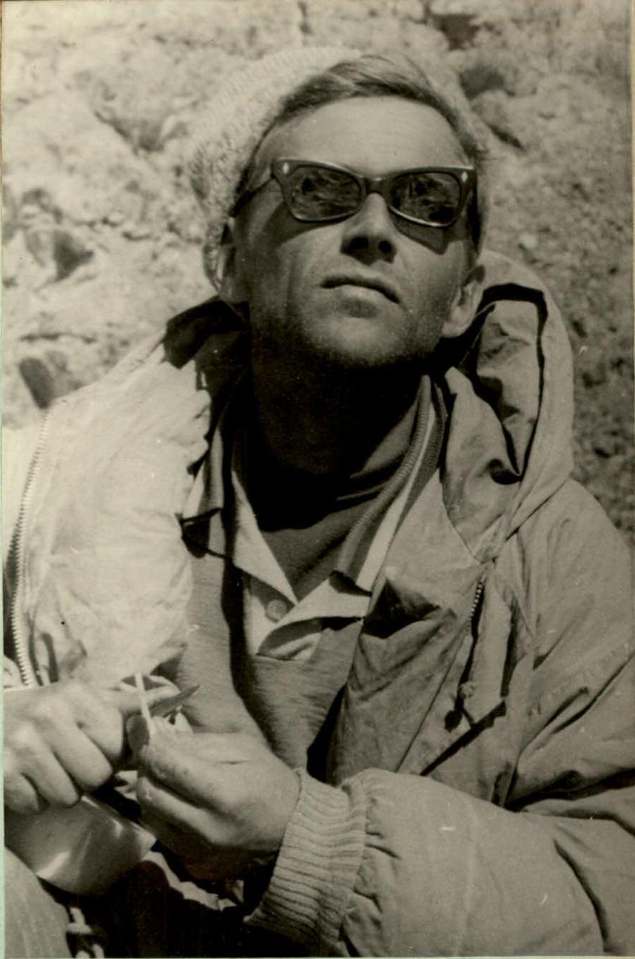
LENGNIK Olgert Mikhaylovich — Master of Sports, participant. Works as a researcher, physicist. Karabalty settlement, Kalinin district, Kirghiz SSR. Has been involved in alpinism since 1952. Participates in the USSR championship for the second time. 1965. Inspection of the counterfort in profile from the western side and 2) "testing" the state of snow when the temperature regime changes throughout the day.
July 20, 1965 — ascent to Giediminas Akstinas Peak (4270 m) via route 2A cat. difficulty.
Group Composition
Yeropunov A. (team leader)
- Aksenov V.
- Lengnik O.
- Tishchenko V.
- Akhsaniv G.
- Podkuyko A.
- Sapalov U.
- Strel'tsov Ye.
- doctor Tveritneva A.
July 23, 1965. First ascent of the unnamed peak 4205 m via a route approximately 3A cat. difficulty, named "Zhashtyk-yunost'" Peak in honor of the 40th anniversary of the Komsomol in Kirghizia.
Group Composition
Strel'tsov Ye. (team leader)
- Aksenov V.
- Romanov A.
- Lengnik O.
- Sapalov U.
- Akhsaniv G.
Due to the fact that all participants of the upcoming ascent were well-trained and had already completed climbs of 4-5 cat. difficulty in the period preceding the ascent, we limited ourselves to these two outings and had a complete understanding of the path to Karakol'sky Peak. It was established that the lower part of the route should be traversed not via the "Bear's Paw" rocks, but along the ridge of rocks adjacent to the ice falls. This was due to safety concerns, as the "Bear's Paw" rocks were prone to avalanches from the slopes above.
During the ascent to "Zhashtyk-yunost'" Peak, we made observations about the state of snow slopes and ridges of various exposures. In particular, our concerns about the snow becoming "slushy" were dispelled. Steep snow ridges with the same exposure as the counterfort maintained their density throughout the day.
Testing of "Nedra-1" radios showed that radio waves were unable to penetrate at a distance of 3-5 km, and even closer, despite the radios being in full working order. A similar situation occurred:
- in 1964, when during a traverse of Karakol'sky Peak, two groups were unable to establish communication with each other;
- in 1959, when an experienced radio operator from the Frunze radio club, V. Mil'ko, was unable to establish communication with Przheval'sk on a short-wave RBM station.
4.
According to the plan, the team was to prepare food and equipment in the "Ala-Archa" alpine camp on July 13-14 and travel to Przheval'sk on July 15-16, then approach the On-Tor glacier. However, two days were lost: one due to a delay in the camp (not the team's fault) and one day due to a bus breakdown. Thus, the team's work on the main route began not on July 22, as planned, but on July 25. Otherwise, the team followed the planned schedule.
The tactical plan for the ascent was designed so that the snow sections would be traversed during the early morning or evening hours. However, the ascent showed that the snow did not become wet even during the day. During the ascent, we were able to distribute the time spent on traversing individual sections very efficiently. The team did not invent new equipment. We widely used:
- cables worn on the middle of the ice axe handle for insurance on snow.
We used:
- universal titanium rock pitons;
- titanium wedges.
The team did not use untested equipment.
5.
The main team consisted of 8 people. At the last moment, A. Balinskiy was unable to join due to work commitments. It was not possible to replace him from the reserve team. In connection with this, according to the team's decision, A. Podkuyko from the main group did not participate in the ascent and joined the observer group.
The team completed the ascent with 6 people:
- Romanov A. V. (team leader)
- Yeropunov A. N. (deputy leader)
- Lengnik O. M.
- Aksenov V. A. (all Master of Sports)
- Akhsaniv G. Z. (Candidate for Master of Sports)
- Tishchenko V. S.
All were from the original main roster.
6.
Route Description (Fig. 2).
The description of the path is given in sections marked with numbers, and within the sections — by points on the route. The time taken to traverse the sections is indicated for the first climber.
July 25.
- Approach from the base camp to the On-Tor glacier 3100 m — 3420 m.
- 2 hours.
- Photo 1
July 26.
- Departure from bivouac at 4:45.
- Crossing the glacier with a slope of 20-25°, ascent up an avalanche cone at 35° to the bergschrund, crossing the bergschrund via a bridge — 30 min.
- Traversing an ice slope covered in snow, slope 55° — 35 m to the right towards rock outcrops, ice is glacial. Movement on crampons. Insurance — two ice screws, rock outcrops. 25 min. Ice-covered rocks, destroyed, 70°, 35 m, insurance — one ice screw, one rock piton, rock outcrops. 25 min. Ice-covered rocks, destroyed, 70°, 35 and 40 m. Insurance — one ice screw, 5 rock pitons, rock outcrops. Time — 57 min. Photo 2a
- Rocks 70° — 25 m, rocks 90° — 10 m. Rocks 80° — 10 m. Pulling up backpacks. Insurance: 6 rock pitons, rock outcrops. Time — 93 min.
- Ice slope 60° — 50 m, then slope 70° — 30 m and another 40 m — rocks with a slope of 75°. Difficult climbing with clearing of handholds from ice and snow. Pulling up backpacks. Insurance: 4 rock pitons, 4 ice screws, rock outcrops. Time — 1 hour 30 min. On a ledge, the group waited for two hours due to a storm: sleet, then snowfall, fog, wind. Photo 2
- Heavily snow-covered monolithic rocks with an overall slope of 65° — 80 m, exiting onto the upper boundary of the rocks. Insurance via pitons and rock outcrops. 5 rock pitons hammered in. Time — 1 hour 25 min. Height 3855 m. Due to bad weather, stopped for bivouac at 13:30. Photo 3
Working time for the day — 6 hours 45 min.
Pitons hammered in:
- Rock — 21
- Ice — 8
Height gain for the day — 435 m.
July 27. Departure from bivouac at 12:00 due to bad weather. Signs of improving weather:
- snowfall,
- breaks in the fog. The path was visible periodically. Movement on crampons.
- From the overnight stop, a snow ridge 40 m — 35°, then an ice slope covered in snow, 25 m — 60°. 55 m of a very steep, up to 80°, ice slope with an exit beyond an ice pyramid. Cutting steps above head level. Insurance via ice screws. Snow slope 40 m — 55° and 40 m along rocks with a slope of 45°. 12 ice screws and 2 rock pitons hammered in. Time — 3 hours 40 min.
- Ice ridge covered in snow, 45 m, slope up to 70° — 6 ice screws hammered in. Cutting steps, time — 1 hour 10 min.
- 110 m snow ridge with a slope of 50°. Insurance via ridge and ice axe — cable. Time — 50 min. Photo 4
- Snow ridge 160 m with a slope up to 60°. Snow is dry, loose. Forming steps. Insurance via ridge and ice axe — cable. Time — 1 hour 30 min.
Second overnight stop at a height of 4170 m above a rock outcrop on the eastern slope of the counterfort. Platforms were cut into the snow slope. Working time for the day — 7 hours. Pitons hammered in: rock — 1, ice — 18. Height gain for the day — 315 m.
July 28. Departure from bivouac at 8:30. Weather is clear. Frost.
- From the bivouac site to the 2nd belt of rocks — a snow ridge with cornices. The slope of the ridge varies. 100 m — 55°, then a section of 45 m with a slope up to 65° and a gradual flattening to 45°, a section of snow ridge with cornices 110 m leads to the base of the second belt of rocks, which are sheer and overhanging. Section 10 was traversed in 2 hours. Insurance via ridge and ice axe — cable. Photo 5, Photo 6
- A cornice is cut through, descent to the left 40 m down a snow-ice slope with a slope up to 80° (under the cornice overhang), crossing a couloir towards a rock ridge. Step cutting. 4 ice screws, two rock pitons. Then upwards along rocks with a slope of 80°. Rocks are monolithic, ice-covered. 80 m of very difficult climbing. 18 rock pitons and one ice screw (in rocks) hammered in on the 80 m section. On two 40 m sections, backpacks were pulled up. Time — 5 hours 30 min. Photo 7
- Rocks of medium difficulty, monolithic — 20 m, slope 60°, two rock pitons, rock outcrops. 20 min. Gentle snow-covered rocks 20 m, a ledge approaches a 10 m sheer, местами нависающей wall. Rocks — crystalline schist, smooth. First climber is "podсажен" (lifted), ladders used. Pulling up backpacks. All subsequent climbers ascended using a sports method with a safety rope. Very difficult spot. 6 rock pitons. Time on 10 m — 2 hours.
- Oblique traverse of a "жандарма" (rock pinnacle) on the left — one rope length 40 m. First, rocks of medium difficulty with a slope of 60°, then a rock wall 10 m with a slope of 75°. Rocks are ice-covered. 4 rock pitons hammered in. 45 min. Then 60 m of snow-covered rock slabs. Climbing with clearing of snow, slope 60°. 3 ice screws hammered into rocks and 3 rock pitons. Time — 1 hour.
- Ascent up a snow ridge transitioning into rocks of an ice fall 60 m — 55° and further 160 m up a snow slope from 45 to 60° to the bergschrund. 4 ice screws hammered in, insurance via ridge, ice axe — cable. Time — 1 hour 45 min. Overnight stop in the bergschrund, under the protection of an ice overhang. Working time for the day — 13 hours. Pitons hammered in: rock — 35, ice — 12. Height gain for the day — 435 m.
July 29. Departure at 8:00. Clear. Frost.
- From the bergschrund, ascent up a snow slope towards rocks on the ridge 120 m, slope 55°. Then under the rocks 80 m, slope 65°, exit onto the ridge. 4 ice screws, 1 rock piton hammered in. Time — 1 hour 40 min. Photo 9
- Along the ridge, traversing a cornice 10 m and then along a snow slope towards the base of a "жандарма" (rock pinnacle), total 40 m, slope 50°. From here, ascent onto the ridge behind the "жандарма" along rocks 50 m, slope 65°. 6 rock pitons hammered in. Snow ridge with cornices 80 m, 30°. Then a steep ridge, ascent 120 m with slope up to 65° in some areas, flattening of the ridge, 80 m with a slope of 35° along the ridge with cornices, but traversing cornices on the left along an ice slope covered in snow with a slope of 55-60°. Insurance via pitons and ice axe. 4 ice screws hammered in. Time — 2 hours 45 min.
- 120 m traverse along the ridge below cornices, exiting towards the base of a "жандарма". Slope 50°. Path character: ice slope covered in snow, movement on crampons. On the ridge at the base of cornices, there are hidden crevasses. Step cutting in some places. Insurance — 5 ice screws, ridge insurance, and from a crevasse. Time — 1 hour 45 min.
Cutting through a cornice 5 m, then ascent onto a "жандарма", ice-covered and snow-covered rocks 40 m with a slope of 80°, some sections are sheer, with loose rock boulders. Insurance via pitons. 6 rock pitons hammered in. Pulling up backpacks. Time — 1 hour.
Ascent up snow-covered and ice-covered rock slabs with a slope of 60° — 40 m. Organization of insurance is very challenging.
Insurance:
- 2 rock pitons
- rock outcrop
- transition to the other side of the "жандарма"
Time — 30 min.
- A 10 m narrow ridge behind the "жандарма": represents a bilateral cornice — a "шапка" (cap) on a rock base. Cutting through this cornice to the rocks. Time — 30 min.
- Very challenging snow ascent on the ridge. First, ascent onto the ridge along a 70° snow slope, then crossing over to the western side of the ridge, where the snow lies almost sheer on the rock base. 1 ice screw hammered into rocks 2 meters below the ridge. Total 40 m. Time — 1 hour 40 min. The ridge was traversed either on top or with the torso leaning to the opposite side.
- Then a bilateral cornice 6 m. Cutting through the cornice. Movement on top of the ridge. Exiting again to the western side of the ridge below a very dangerous cornice, traversing the cornice along a 55° slope — 40 min. Exit to snow-covered rock slabs. 1 rock piton hammered in at the end of the section.
- 100 m of rocks covered with a nearly meter-thick layer of loose snow. Slope 60-65°. Very difficult work clearing rocks from snow. Time — 1 hour 30 min. 8 rock pitons hammered in. Photo 16
- Traverse from the NE counterfort to the eastern short ridge 15 m along an ice slope with a slope of 70°. 2 ice screws, 1 rock piton. Time — 30 min.
- 80 m ascent up a firn-ice slope onto the pre-summit ridge with a slope up to 65°. Insurance via ice axe and 4 ice screws. Time — 20 min.
- Traverse along the ridge with cornices in the direction of the summit along a firn slope with a slope up to 65° on the southern side. Insurance via cable — ice axe. 400 m. Stop for bivouac at 21:00. Overnight location — a wide snow pre-summit plateau at a height of 5235 m. Working time for the day — 13 hours. Pitons hammered in: rock — 25, ice — 20. Height gain for the day — 675 m.
July 30. Departure from bivouac at 7:30. Weather is clear. Frost.
- Along the gentle pre-summit plateau, exit to the summit 15-20 min. Descent along the known path — the eastern ridge with cornices towards "Slonënok" and then onto the On-Tor glacier took the group 8 hours. Photo 17
General data on the route.
Height gain — 1860 m. Average slope — 60-65°. Route length — 2600 m. Working time for ascent — 40 hours. Time for descent — 8 hours. Pitons hammered in:
- Rock — 83
- Ice — 58
- total — 141.

Fig. 2
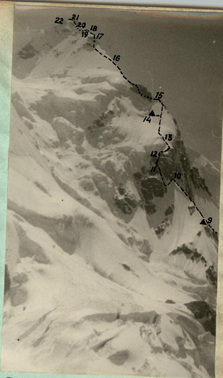
Photo 6. Profile of sections 9 to 22, N-E counterfort from the On-Tor glacier (eastern branch)
Photo 6. Profile of the N-E counterfort from the 9th to the 22nd section. Photo taken from the upper eastern branch of the On-Tor glacier.
TABLE
Main characteristics of the route for ascending Karakol'sky Peak via the north-east counterfort. High-altitude technical climb class.
Height gain on the route: 1860 m. Including the most challenging sections — 520 m: (3-5) — 135 m, section (6) — 55 m, (10-12) — 105 m, section (15) — 50 m, section (16) — 30 m, section (17) — 60 m, section (19) — 20 m, section (20) — traverse of cornices horizontally, sections (21-22) — 65 m. Route slope: variable, average slope 60-65°. Including the most challenging sections: rock sections are sheer, snow ridges with sheer edges and collapsed snowdrifts up to 70°.
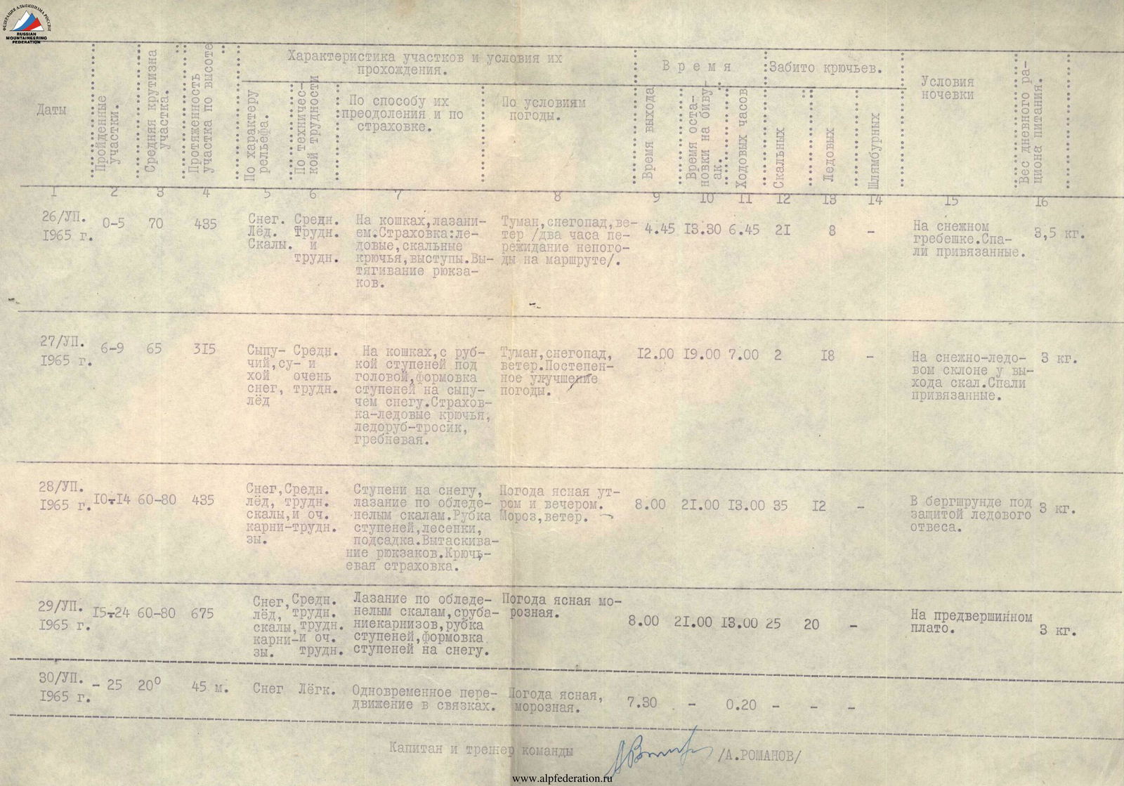
| Date | Sections | Slope (°) | Height Gain (m) | Snow/Ice/Rocks | Difficulty | Movement/Insurance | Weather | Time | Pitons Hammered In (Rock/Ice) | Bivouac Location | Weight (kg) |
|---|---|---|---|---|---|---|---|---|---|---|---|
| 26/VII | 0–5 | 70 | 435 | Snow | Medium | On crampons, climbing. Insurance: ice and rock pitons, rock outcrops. Pulling up backpacks. | Fog, snowfall, wind (two hours weathered on the route). | 4:45 13:30 | 6 h 45 min | 21 8 | On a snow ridge. Tied in. |
| 27/VII | 6–9 | 65 | 315 | Loose dry snow, ice | Medium and very difficult | On crampons, with step cutting above head level, forming steps on loose snow. Insurance — ice screws, ice axe-cable, ridge. | Fog, snowfall, wind. Gradual improvement in weather. | 12:00 19:00 | 7 h 0 min | 2 18 | On a snow-ice slope at rock outcrops. Tied in. |
| 28/VII | 10–14 | 60–80 | 435 | Snow, ice, rocks, cornices | Medium, difficult, and very difficult | Steps on snow, climbing on ice-covered rocks. Step cutting, ladders, "подсадка" (lifting). Pulling up backpacks. Pitons insurance. | Clear weather in the morning and evening. Frost, wind. | 8:00 21:00 | 13 h 0 min | 35 12 | In the bergschrund under an ice overhang. |
| 29/VII | 15–24 | 60–80 | 675 | Snow, ice, rocks, cornices | Medium, difficult, and very difficult | Climbing on ice-covered rocks, cutting through cornices, step cutting, forming steps on snow. | Clear, frosty weather. | 8:00 21:00 | 13 h 0 min | 25 20 | On the pre-summit plateau. |
| 30/VII | — | 25 | 200 45 | Snow | Easy | Simultaneous movement in rope teams. | Clear, frosty weather. | 7:30 | 0 h 20 min |
Photo 7. One of the most challenging sections of the route — the 80 m section of ice-covered rocks of the 2nd rock belt. (sections 11-12).


