ASCENT DESCRIPTION OF "ŽALGIRIS" PEAK
4850 m
VIA SOUTHERN LEFT BUTTRESS 4B cat. diff.
AUGUST 1969
Area of "Žalgiris" Peak
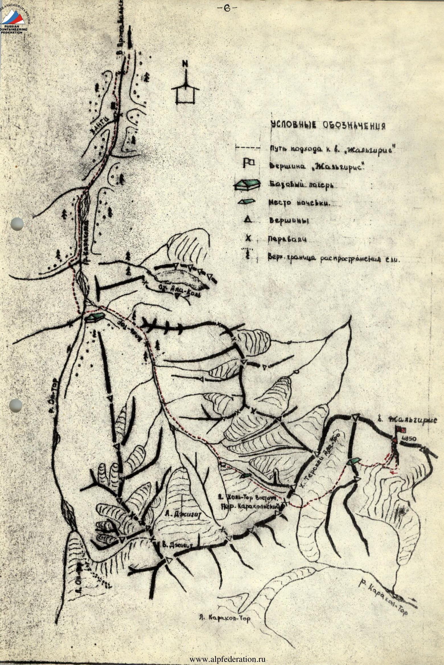
"Žalgiris" peak is located in a spur of the Teskey Ala-Too ridge, between the Sary-Chat and Karakol-Tar valleys, 70 km south of Przhevalsk, Kyrgyz SSR. The peak is composed of granites and in the middle part of yellowish, местами almost white marble.
Height by altimeter — 4850 m
Approach Routes
From Przhevalsk, we move along the Karakol valley to the Köl-Tör river. From here, along the right bank of the Köl-Tör river and the eastern glacier, we ascend to the Karakol pass. From the pass, we descend to the glacier and move east, cross another unnamed pass, and approach the peak along the glacier.
The approach from Teploklyuchenka village along the Altyn-Arašan and Ok-Tor rivers is probably possible but unexplored.
The group left the base camp at the confluence of the Köl-Tör and On-Tor rivers on August 10. Along the right bank of the Köl-Tör river, they approached the campsite on the right-bank moraine of the Karakol glacier. On August 13, the group ascended "Albatross" peak, 5A cat. diff.
On August 15, a group of first-class climbers arrived, with whom they were to interact during the ascent of the unnamed peak with the conditional name "Žalgiris".
On August 16, both groups moved to the area of "Žalgiris" peak. They ascended the Karakol pass and descended to the eastern side of the glacier. They crossed a complex glacier and ascended an unnamed pass. Due to strong winds, they called it "Aerodynamic Tube". The transition took 6 hours. They set up a bivouac here. They studied the route and agreed with the second group, led by Zdanavičus R., on the interaction during the ascent. Their group planned to ascend via the left southern buttress, and the other group — via the right southern buttress.
Route Description
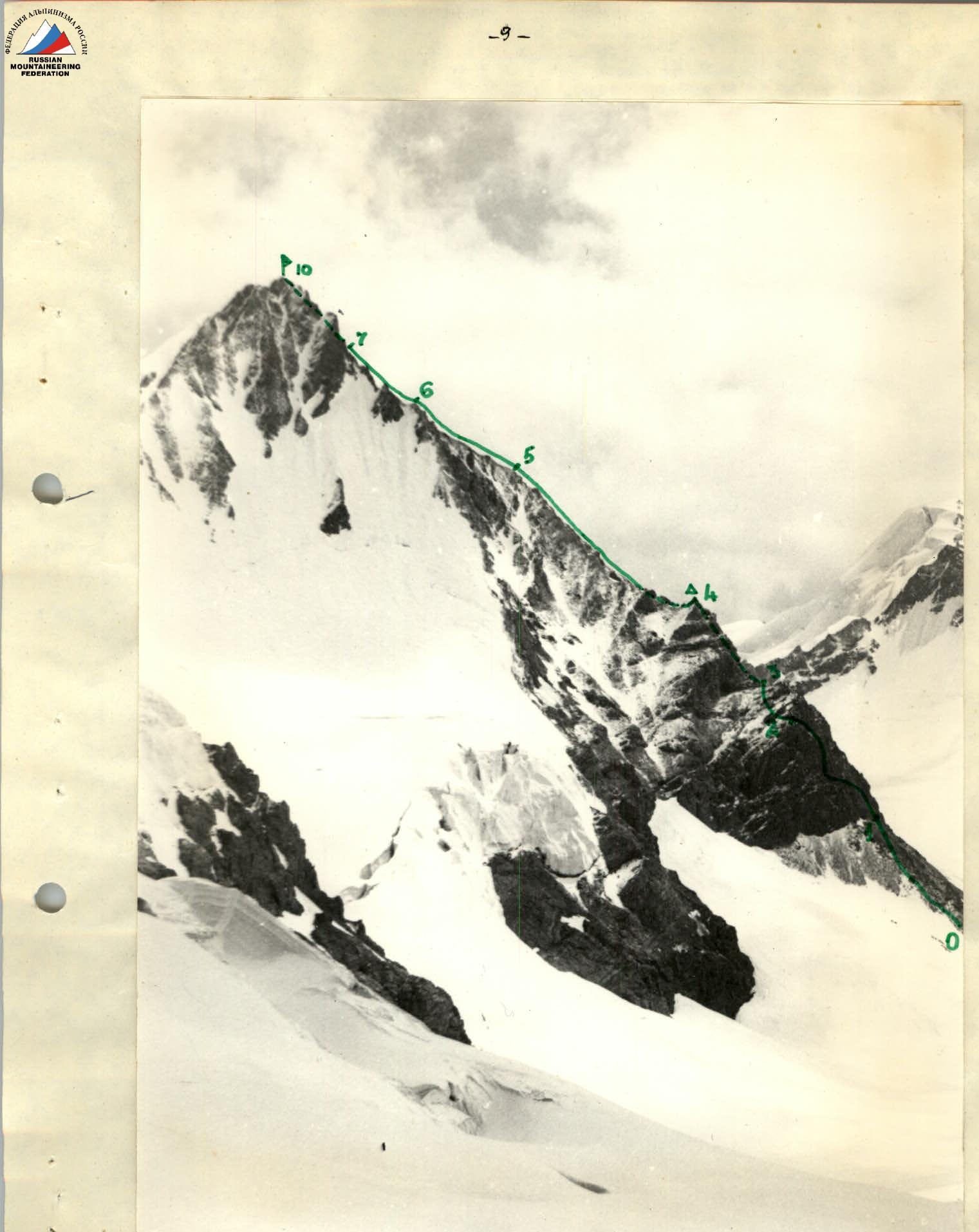
At 5:00, the group left the bivouac located on the "Aerodynamic Tube" pass. They descended along the closed glacier to the east, to the foot of "Žalgiris" peak.
Section R0–R1. Along ice (40°–300 m) and large scree (300–100 m), we approach the left buttress of the peak.
Section R1–R2. Wall 70°–65 m. We ascend via an inner corner with difficult climbing. Then we traverse left and up along difficult rocks. Belay via outcrops and rock pitons. Then we cross a loose couloir. We approach an inner corner (45°–100 m), which we overcome by climbing. Five rock pitons were hammered.
Section R2–R3
Along loose, medium-difficulty rocks, we ascend to the ridge under a light-brown gendarme (40°–0 m).
Section R3–R4
We bypass the gendarme on the right along a steep wall 80°–130 m; five rock pitons (bypass is difficult). If there were pitons and ladders, it would be reasonable to overcome the gendarme "head-on".
Then we descend using a sports method along an icy slope and "ram's foreheads" (70°–40 m). We traverse a wide couloir and ascend along loose rocks to the ridge. Along rocks of medium difficulty, we ascend to a red-brown gendarme. Here we build a control cairn.
Section R4–R5
Further, we move along the ridge with a series of small gendarmes. The first two gendarmes are bypassed on the right. The next gendarmes are overcome "head-on". Belay via outcrops and pitons (35°–110 m; four rock pitons). Rocks are yellowish marble, loose.
Section R5–R6
From the last gendarme, along easy rocks, we reach the junction of the left and right buttresses.
Section R6–R7
Snowy icy slope. Initially, gentle, then steep (50°–80 m; one ice piton). Further, the slope becomes gentle again and then steep again (50°–40 m; one ice piton). We approach a steep couloir leading to the summit.
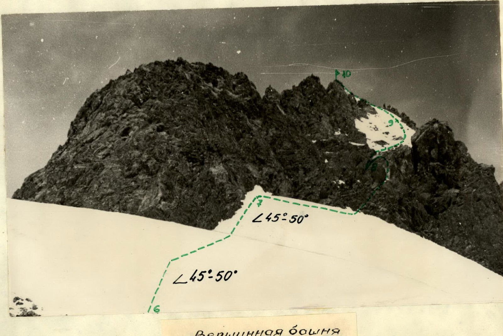
Section R7–R8
The lower part of the couloir is stone-hazardous. Rocks are icy. We bypass this part of the couloir on the right along rocks of medium difficulty (50°–40 m; three rock and two ice pitons).
Section R8–R9
We enter a steep icy couloir (50°–60 m; two ice and two rock pitons). We cut steps.
Section R9–R10
Along a snowy icy slope with rocky outcrops, we reach the summit (45°–30 m; two rock pitons).
The summit is sharp, and only two people can stand on it.
- The southwestern side is a rocky wall
- the northern side — steep snow-ice slopes.
We descend along the ascent route to the junction of the left and right buttresses. Further descent goes along the easier right buttress (approximately 3B cat. diff.). Along the glacier, we returned to the bivouac on the "Aerodynamic Tube" pass.
The ascent took 10 hours. In total, on the route, pitons were hammered: rock — 21, ice — 6. The group evaluates the route as 4B cat. diff.
Group Composition
- Stepuolis V. — group leader, 1st sports category, mountaineer since 1961
- Stankute D. — 1st sports category, mountaineer since 1959
- Žamulaitis Yu. — 1st sports category, mountaineer since 1962
- Šteinas A. — II category, mountaineer since 1962, mountaineering instructor, has experience of ascents to peaks of 4 and 5A cat. diff.
- Pechkaitene I. — II category, mountaineer since 1958, mountaineering instructor, has experience of ascents to peaks of 4 and 5B cat. diff.
- Viršilas V. — II category, mountaineer since 1958, has experience of ascents to peaks of 4 and 5B cat. diff.
Ascent description compiled by: Žamulaitis Viršilas
TABLE OF MAIN CHARACTERISTICS
- Route of the first ascent to "Žalgiris" peak — 4B cat. diff.
- Height difference — 900 m. including complex rocky — 290 m, icy — 190 m.
- Average steepness of the route — 45°. including complex sections: rocky — 80°; icy — 50°.
| Date | Route Sections | Average Steepness | Height of Sections | Characteristics of Sections and Conditions (By relief character) | Characteristics of Sections and Conditions (By technical difficulty) | By Insurance Method | By Weather Conditions | Time (Departure) | Time (Stop on Descent) | Time (Travel, hours) | Pitons Driven (Rock) | Pitons Driven (Bolted) | Pitons Driven (Ice) | Conditions and Weight of Daily Rations | Notes |
|---|---|---|---|---|---|---|---|---|---|---|---|---|---|---|---|
| 1969 | 6:00 | ||||||||||||||
| VIII.17 | R0–R1 | 35° | 90 m | Ice, scree | easy | via outcrops | good | 0.5 | - | - | - | 2 kg | |||
| R1–R2 | 60° | 160 m | Rocks | difficult | via outcrops, pitons | " | 1.0 | 5 | - | - | |||||
| R2–R3 | 45° | 50 m | " | medium | via outcrops, pitons | " | 0.5 | - | - | - | |||||
| R3–R4 | 80° | 130 m | " | difficult | - " - | " | 2.5 | 5 | |||||||
| R4–R5 | 35° | 110 m | Rocks, ice | medium | via outcrops | " | 1.5 | 4 | |||||||
| R5–R6 | 30° | 60 m | Rocks | easy | via outcrops, pitons | " | 0.5 | ||||||||
| R6–R7 | 50° | 170 m | Snow, ice | difficult | via ice axe, pitons | " | 1.0 | 2 | |||||||
| R7–R8 | 50° | 40 m | rocks, ice | medium | via outcrops | " | 0.5 | 3 | 2 | ||||||
| R8–R9 | 50° | 60 m | ice, rocks | difficult | piton belay | " | 1.0 | 2 | 2 | ||||||
| R9–R10 | 50° | 30 m | ice, snow | difficult | piton belay, via outcrops | " | 0.5 | 2 |
 "Žalgiris" peak. View from the west.
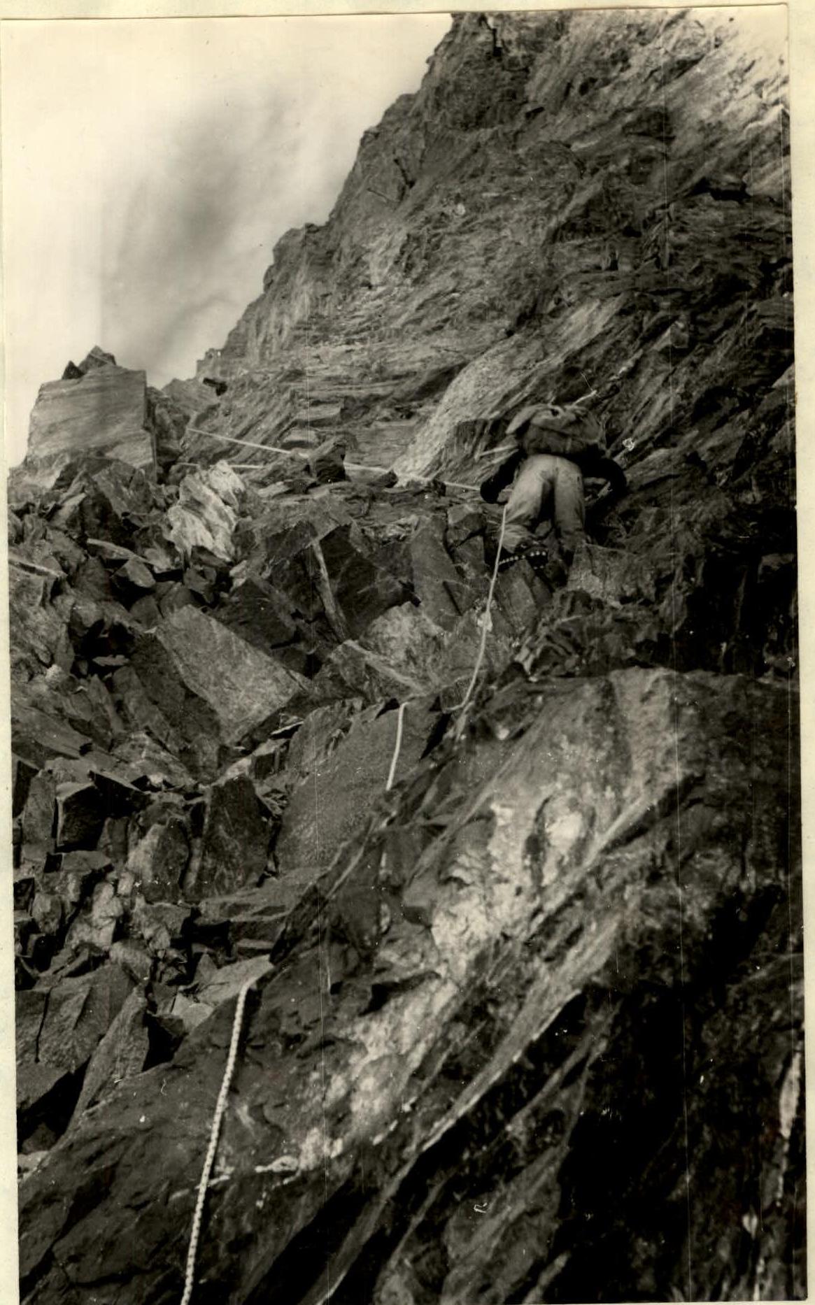
 On section R1–R2
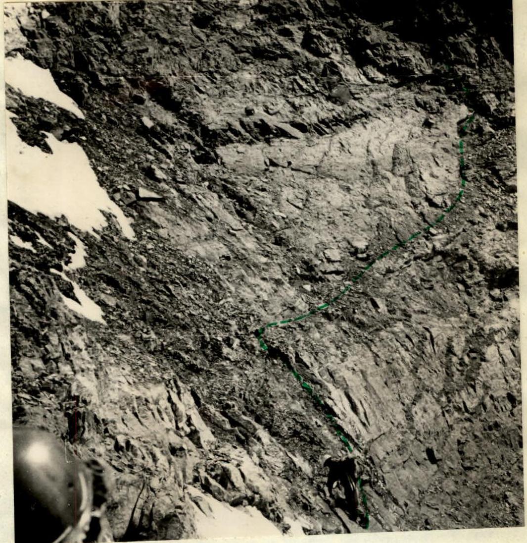
 On section R2–R3
 On section R3–R4