Author: Kirill Belotserkovsky, Almaty
Report on the ascent of Jigit Peak

I wrote a report on our ascent of Jigit Peak. It's a detailed one with numbers, diagrams, and photos. So it doesn't gather dust in the archives of various commissions, I'll post it online, maybe someone will find it interesting.
- Ascent Passport
- Region, valley, section number according to the classification table: Tian Shan, Teskey-Ala-Too, 7.10.44a
- Name of the peak, route name: Jigit via the center of the north face (Slesov's route)
- Category of complexity: 6A
- Nature of the route: combined
- Height difference of the route: 1200 m
- Length of the route: 1400 m
- Average steepness of the main part of the route: 75°
- Average steepness of the entire route: 60°
- Equipment used on the route:
piton - 90 pieces, chocks - 100 pieces, ice screws - 18 pieces, stationary bolts - 15 pieces, including 5 for artificial climbing. Pitons left on the route - none
- Team's total climbing hours: 40 hours 3 minutes 30 seconds
- Leader: Belotserkovsky Kirill Alexandrovich, Candidate Master of Sports
- Participant: Ten Maxim Valentinovich, Candidate Master of Sports
- Coach: Skopin Artem Alekseyevich, Master of Sports
- Departure for the route: August 28, 2014, 4:00 AM
- Summit ascent: August 31, 2014, 12:00 PM
- Return to base camp: August 31, 2014, 6:00 PM
- Organization: FAiS RK
General photo of the summit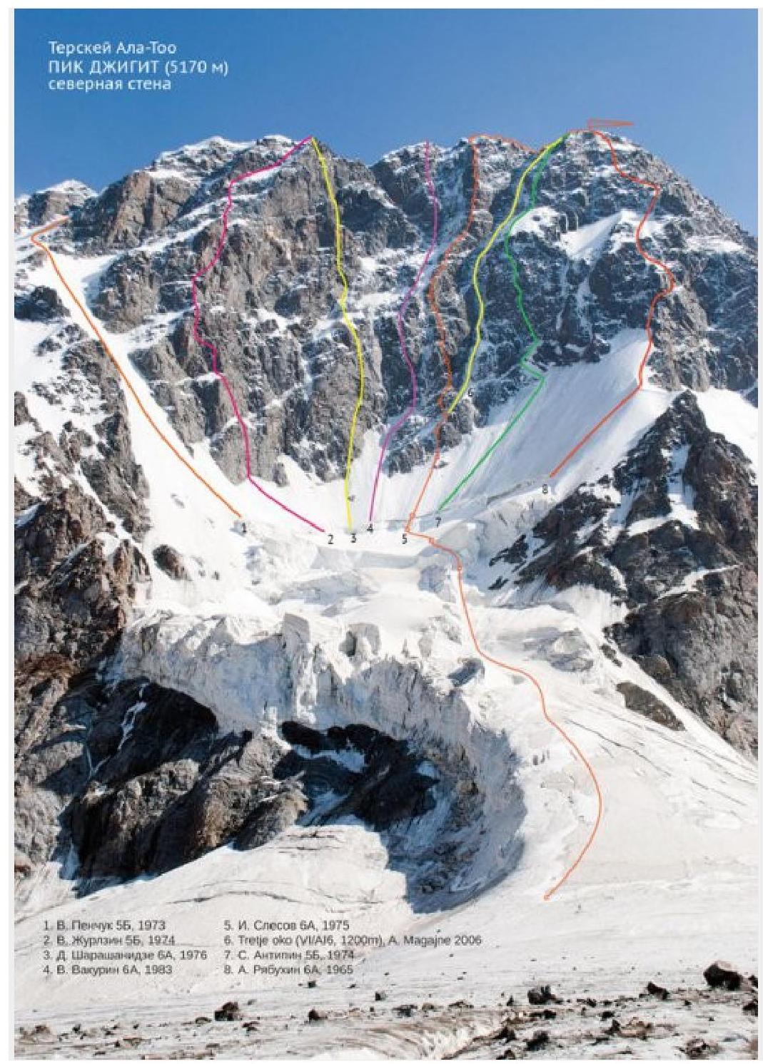
Jigit Peak, routes on the north face
Characteristics of the region and the object of ascent
The Teskey Ala-Too range is located in the northeast of Kyrgyzstan and bounds the Issyk-Kul depression from the south. The average height of the range is 4500 m above sea level, and the maximum is 5281 m (Karakol Peak). The length of the range in the latitudinal direction is about 400 km.
The Teskey Ala-Too range ranks second (after the Meridionalny range) in terms of glaciation in Tian Shan. The area of glaciation is 1081 km². Massive glaciation and the proximity of a large lake are the reasons for the unstable weather in the area.
Jigit Peak (5170 m) is the second highest peak in the area, located in the upper reaches of the Kultor River.
The simplest route is along the western ridge (S. Silchenko, 1966) 4A. It is also the descent route.
The north and northwest faces are of the greatest interest. The northwest face has routes of the fifth category, and the north face has mostly "sixes":
- D. Sharashanidze, 1976 (first place at the USSR championship in the technical class)
- V. Vakurin, 1983
- I. Slesov, 1975 (first place at the USSR championship in the technical class)
- A. Ryabukhin, 1965
All routes have a mix of rock and ice. The rocks are mostly monolithic. Cracks are often filled with snow or ice. There are no convenient ledges on the face, so bivouac sites have to be prepared: ice has to be chopped, stones have to be placed, etc. Comfortable lying-down bivouacs are only available on the ridge.
I. Slesov's route has a combined nature. We often had to switch from rock climbing to ice climbing and then to a combination of both in different proportions. The first climber tried to maximize the use of free climbing on ice tools. Actual climbing, in the usual sense of the word, was almost nonexistent. Constant use of tools on rocks was dictated by both the terrain features (ice-covered rocks) and the bad weather that accompanied us every day. The first climber worked with a lightened backpack, while the second followed on jumars and carried bivouac equipment.
Route diagram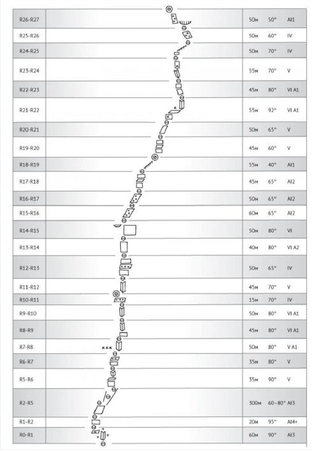
Jigit Peak, Slesov's route
Technical description of the route
The approach from the bivouac site goes along the open glacier in the direction of the right part of the icefall at the lower part of the face. After a long observation, we chose a passage through the icefall in the evening, as it presented a certain difficulty. We linked up before starting the gentle ice slope. We tried to pass the icefall as quickly as possible, encountering fresh ice debris along the way.
R1–R2: exit to the ice slope under the bergschrund. First, on steep ice covered with a thick layer of loose snow, then traversing left along an ice ledge.
R2–R3: approach along simple ice under the bergschrund.
R3–R4: overcoming the bergschrund. An overhanging ice wall, partially covered with a thick layer of loose snow. We had to dig a trench in the snow, using ice screws to organize artificial climbing.
R4–R5: moving right-up towards a steep ice couloir.
R5–R6: alternating between walls and ledges under an internal angle with an ice flow. A complex dry tooling (artificial climbing) upwards.
R6–R7: right-up along walls - ledges, covered in ice, towards an internal angle. To the left of it, judging by the bolts, one can bivouac.
R7–R8: complex climbing up the internal angle.
R8–R9: climbing (artificial climbing) up the angle. The weather started to deteriorate: snow began to fall, and the wind picked up.
R9–R10: towards the top, the angle opens up. Mostly artificial climbing. Station on a local bolt, blocked with something of our own.
R10–R11: along an ice ledge and a rocky internal angle to the top of a spall. There is a ledge one and a half meters wide. Uncomfortable sitting bivouac.
R11–R12: descent to an ice ledge, traverse right. Further movement upwards along an internal angle with ice. Cold. Mostly artificial climbing.
R12–R13: alternating between walls - ledges with ice. Climbing is relatively simple.
R13–R14: confident artificial climbing up a wall to the right of a cornice.
R14–R15: upwards until the terrain becomes gentler. Snow started to fall.
R15–R16: movement upwards along moderately complex rocks, covered in ice.
R16–R17: the same.
R17–R18: through a rocky step to an ice ridge.
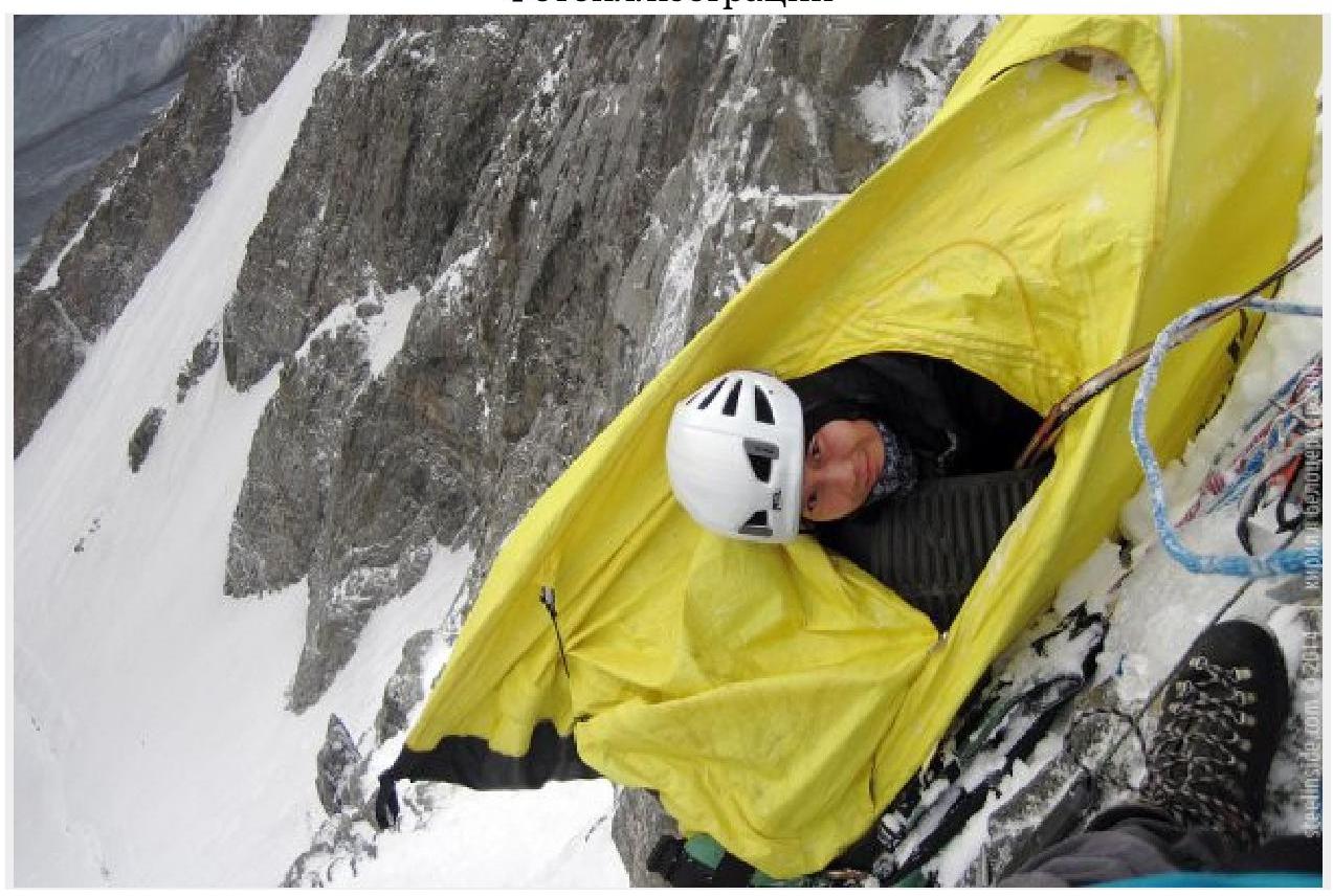
R18–R19: along a simple ice slope upwards to rocks. By this time, visibility had dropped to 10 m. Strong wind, heavy snowfall. Everything suggests a bivouac. We chopped out a ledge in the ice (broke a shovel on one of the tools in the process). Semi-reclining bivouac.
R19–R20: movement upwards along the most logical terrain.
R20–R21: slightly left-up towards an overhanging wall with a bolted route. After it, traverse right, then up a steep internal angle.
R21–R22: left - up along a steep wall onto broken (but ice-cemented) rocks. It's possible that this section can be bypassed if one moves right from the station instead of left.
R22–R23: climbing along steep, sometimes overhanging rocky fins, frozen in ice. Despite the steepness, climbing is not too complex. Dry tooling.
R23–R24: along gentle rocks right - up. Along the way, we encountered an old bolt. Station just below a rocky ridge. The weather started to deteriorate.
R24–R25: along a rocky ridge and further along rocks, covered in ice.
R25–R26: along rocks, covered in ice and snow, upwards under a small cornice. Very strong wind, snowfall. Visibility is severely limited. Powder avalanches constantly pass through the cornice.
R26–R27: from under the cornice left-up along a rocky internal angle and further along a steep snow-ice slope to the ridge. On the slope, we couldn't dig to normal ice even once, so we couldn't organize insurance. On the ridge, we chopped out a small ledge and set up a tent. Comfortable lying-down bivouac.
R27–R28: in conditions of poor visibility, 200 m along a snow-ice ridge with cornices to a short rocky step.
R28–R29: descent 5 m.
R29–R30: 250 m along the ridge with huge cornices to the summit dome. We didn't reach the highest point, as it's likely a cornice.
Tactical actions of the team
On July 28, 1953, at 4:00 AM, we set out on the ascent. We passed the icefall and began working on the route, which consists of steep rocks, interspersed with ice sections.
Throughout the second half of the day, it snowed, accompanied by wind. By 6:00 PM, the bad weather intensified, and we decided to bivouac. We spent the night sitting in a tent on a small ledge (one and a half meters wide).
July 29:
- it snowed all day,
- despite this, by 7:00 PM, we reached a snow-ice ridge before the start of the second steep rocky section,
- to organize a bivouac, we had to chop out part of the ice ridge,
- we slept semi-reclining.
July 30:
- the weather was satisfactory for most of the day,
- thanks to this and the fact that the terrain, despite the retained steepness, became simpler, we managed to reach the ridge,
- we reached the ridge in deep twilight and in conditions of very strong bad weather,
- we chopped out part of the ridge, set up a tent.
July 31:
- along the ridge with large snow cornices, we reached the summit,
- took photos and began our descent,
- within 5 hours, we were back on the glacier,
- through the On-Tor pass, we reached our camp under the face, where we bivouacked.
Technical photography of the route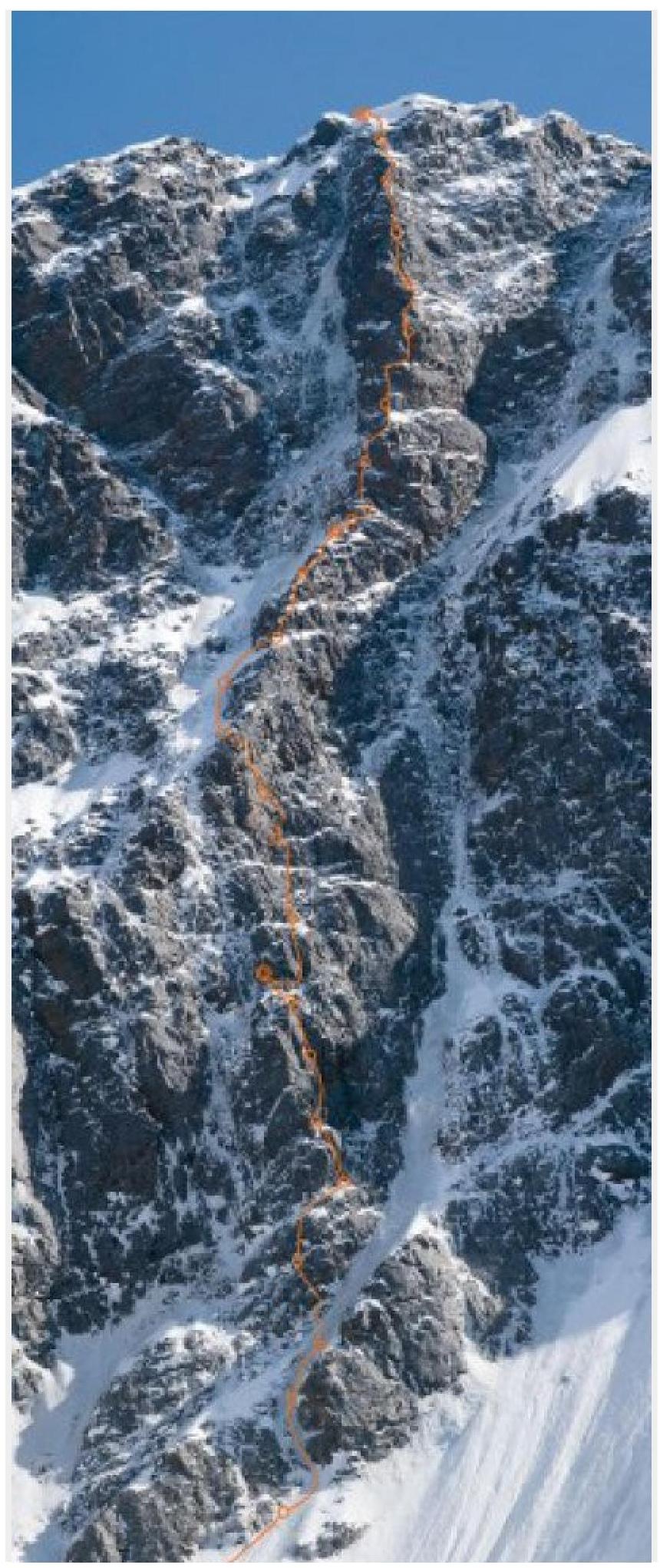
Digitized by Google Jigit, north face. Photo illustrations