- Technical class
- Terskey Ala-Too, Karakol gorge
- Jigit peak via the center of the North wall
- 6B category of complexity, second ascent
- Height difference: 1120 m, length of the wall section of the route to the ridge 1125 m, length of sections 5–6 category of complexity 750 m, average steepness of the main part of the route 77°
- Pitons driven:
| rock | bolt | nuts | ice screws |
|---|---|---|---|
| 81/21 | 0/0 | 76/25 | 26/4 |
- Climbing hours: 29 and days 2.2
- Overnights: 1st sitting on an inclined shelf, 2nd lying on a snowy ridge
- Leader: Sergey M. Antipin Master of Sports of the USSR. Members: Andrey M. Belov Candidate for Master of Sports, Leonid M. Rybalko Candidate for Master of Sports, Vladimir A. Sereda Master of Sports of the USSR, Anatoly K. Shlyopkin Candidate for Master of Sports.
- Coach: Sergey M. Antipin Master of Sports of the USSR. II. Departure to the route: August 7, 1984. Summit August 9, 1984, return August 9, 1984.
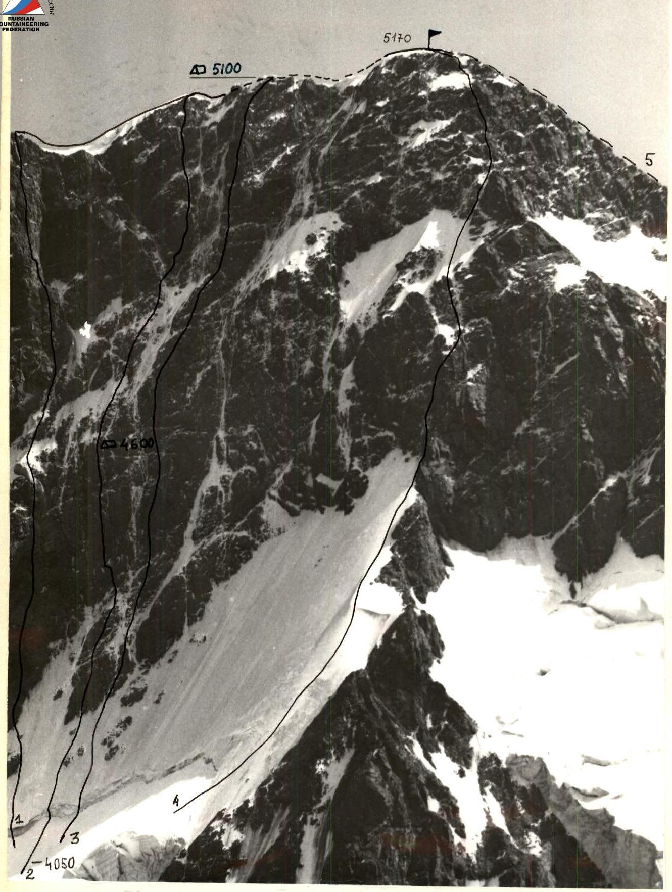
Taken on August 15, 1984 at 16:00, camera "Lyubitel", distance to the wall about 1.5 km, height 4400 m, shooting point #1.
- D. Sharashe nidze's route, 6B category of complexity.
- V. Vakurin's route, 6B category of complexity.
- I. Slesov's route, 6B category of complexity.
- A. Ryabukhin's route, 5B category.
- Route 4A category of complexity (1st descent path)
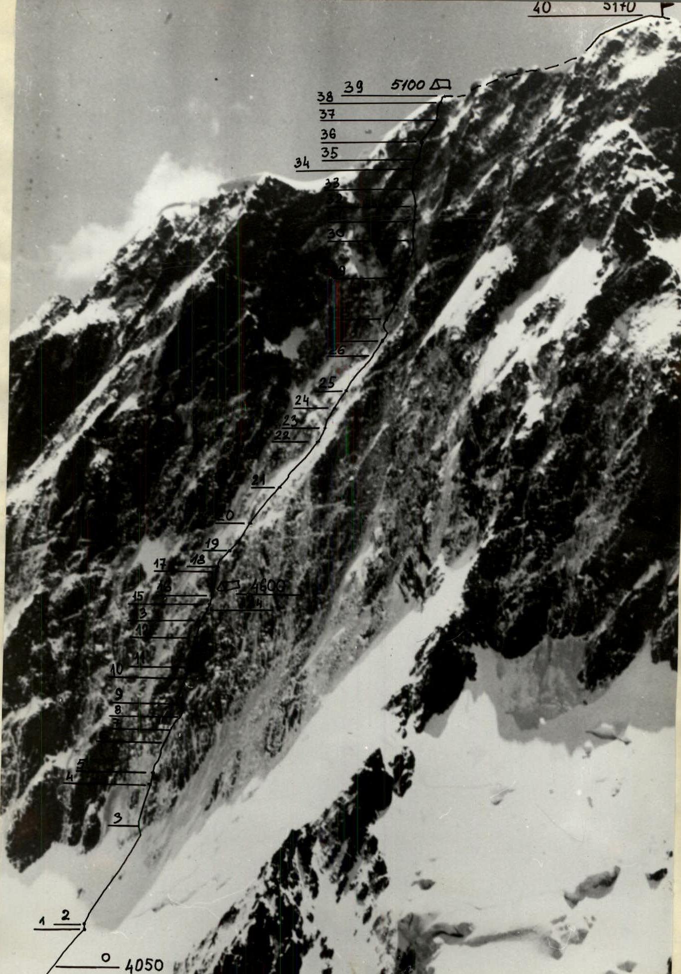
Profile of the wall on the right 4600 — overnight locations indicating height. Taken on July 27, 1984 at 17:00 after three days of bad weather, lens "Helios-44", focal length = 50 mm, distance to the wall about 3 km, shooting point #2.
Tactical actions of the team
The whole route the team worked using a double rope. The scheme of movement is as follows:
- The first one goes on a double rope, fixes one rope, and insures the second participant with the other.
- The second one climbs with top rope on the fixed rope and carries a free rope.
- The fixed ropes are secured by the second participant in the middle of the rope so that two people can move on one rope at once.
- In parallel to the fixed ropes, a second rope is fixed, to which the 3rd and 4th participants are tied with a Prusik knot.
- The last one climbs with top rope on the fixed ropes using two jumar.
Pulling up rucksacks was not planned and was not carried out, as in our opinion, it is a waste of strength and time.
There were no deviations from the tactical plan during the ascent. A change of leader was planned: sections R6–R7 and R20–R22 were passed by V. Sereda, R7–R20 by A. Shlyopkin, R22–R39 by S. Antipin.
During the ascent, daytime stops were not planned. All participants were provided with individual rations, and tea was in flasks, which were evenly distributed among the team members. Hot meals were only on overnight stops.
Only one sitting overnight stay on the wall was planned.
On the overnight stop, the following were organized:
- fixed ropes,
- everyone slept in helmets and on self-arrest.
Although the route is not considered rockfall-prone, an early start was planned and carried out on the first day. The overnight location was chosen under the cover of a cornice, and rockfall-prone sections were passed one by one. Belaying and self-arrest were organized reliably.
Since many sections of the route were iced over, in the leading team, one worked in "Vibram" boots or galoshes, and the other was always in crampons with ice climbing equipment. This allowed for a quick change of leader when changing terrain.
Observers constantly monitored the ascent with binoculars, and they also received information from us every 3 hours, which was communicated via the "Romashka" radio station.
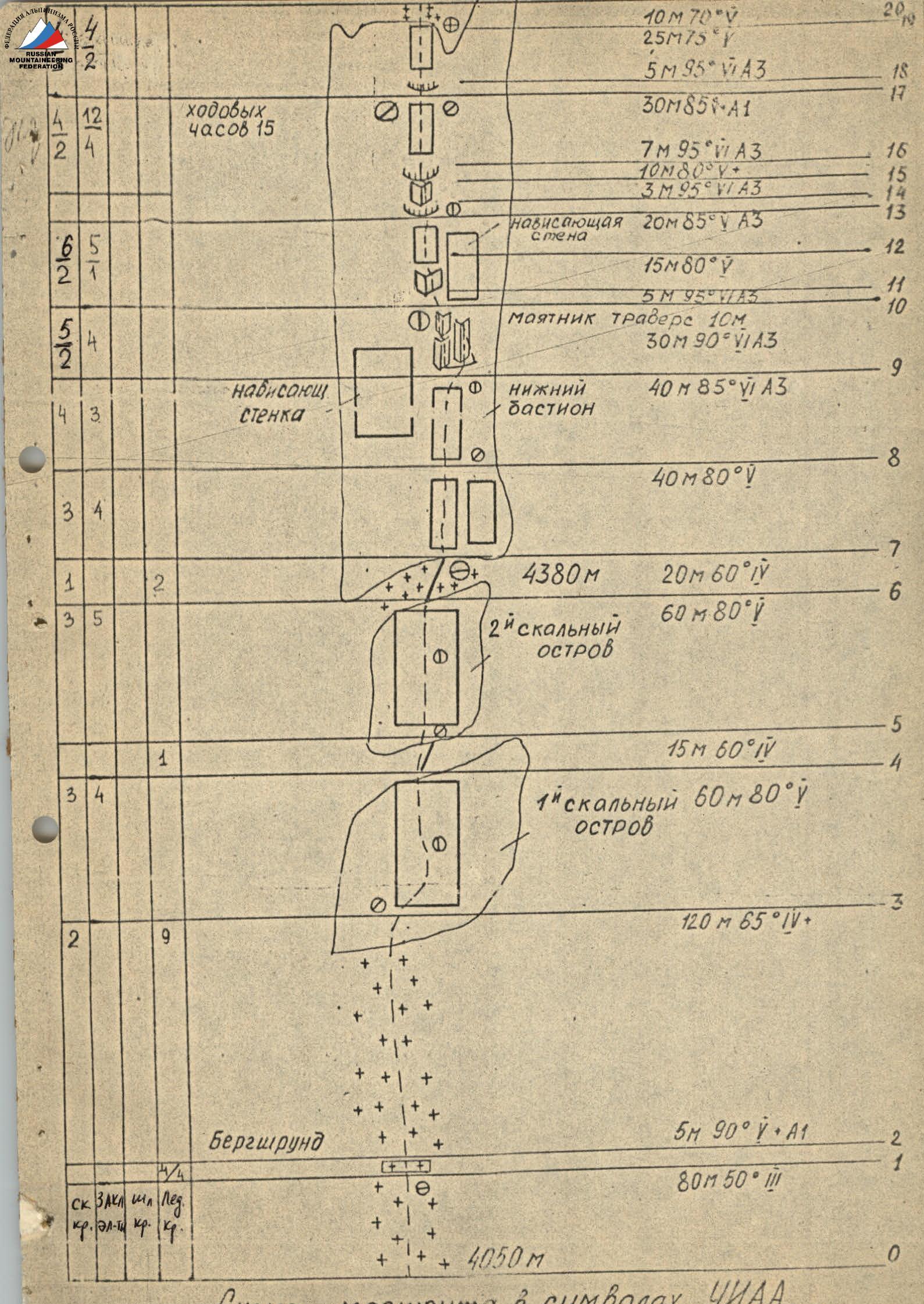
Route diagram in UNAA symbols.

Description of the route by sections
R0–R1. Snow-ice ascent from the snow pad of the cirque to the bergschrund.
R1–R2. Bergschrund, the upper wall slightly overhangs and is covered with a thick crust of loose firn, it is possible to get a hold on the solid ice only after chopping off this crust. Passed with the help of:
- "ice axe leash"
- ice axe
R2–R3. Ice about 120 m long, average steepness.
R3–R4, R5–R6. Two rocky islands. They are steep rocky walls covered with ice. There are no convenient belay points here.
R4–R7. Ice ridge with frozen stones.
R7–R19. Lower bastion. This is a very steep, monolithic wall about 250 m long, its steepness varies from 80 to 90°. This is the key section of the entire route. Passing it is greatly complicated by ice accretion, which has to be chipped away to find cracks and holds. There are no places on this section where the group could gather together, there are no places for comfortable overnight stays or for belaying.
R8–R9. Monolithic rocky wall with an overhang in the upper part. When passing this section, nuts — "stoppers" were used.
R9–R10. Passing this section is only possible using a pendulum, complicated by a small number of cracks. On this section, ladders were used. Very difficult climbing.
R10–R11. Five-meter overhanging rocky wall. Its passage required the use of ladders.
R11–R13. Inner corner filled with ice accretion. Ends with an overhanging wall. There are very few cracks. Ladders were used when passing.
R13–R16. Series of cornices, their passage requires the use of ladders. Very difficult climbing.
R16–R19. Rocky wall, heavily iced, ending in a rocky cornice. When passing this section, nuts are significantly used.
R20–R21. Bend of the lower bastion. In the upper part, there is a convenient place for belaying.
R21–R22. Ice slope, steepness about 70°. The slope rests against an overhanging rocky wall about 15 m high.
R22–R25. Third rocky island. This is a series of rocky walls of the "sheep's forehead" type with a small number of cracks and holds, which have to be chopped out in the ice accretion.
R25–R26. Ice slope of average steepness.
R26–R28. Rocky wall, which ends with a steep shelf filled with ice. From below, this shelf looks like a couloir.
R29–R38. Upper bastion. General characteristic — a wall with a large-block structure. In the lower part and especially in the middle, very steep, in the upper part — it becomes less steep. The rocks are iced over.
R29–R30. Inner corner filled with ice. Very difficult climbing, ladders are used.
R30–R31. Rocky shelf composed of light granite rocks. From below, it looks like a light strip.
R31–R34. Rocky walls, partly iced. Passed using ladders. One of the difficult places on this section is a five-meter overhanging section. The section ends with a feather-like cornice.
R34–R36. Snow ridge and exit to a rocky shelf. Traverse to the left.
R36–R38. Inner corner. Very difficult climbing, rocks are dry, there are cracks for pitons and nuts, ladders are used.
R37–R38. Rocks of average difficulty and exit to a snow-firn ascent of the main ridge.
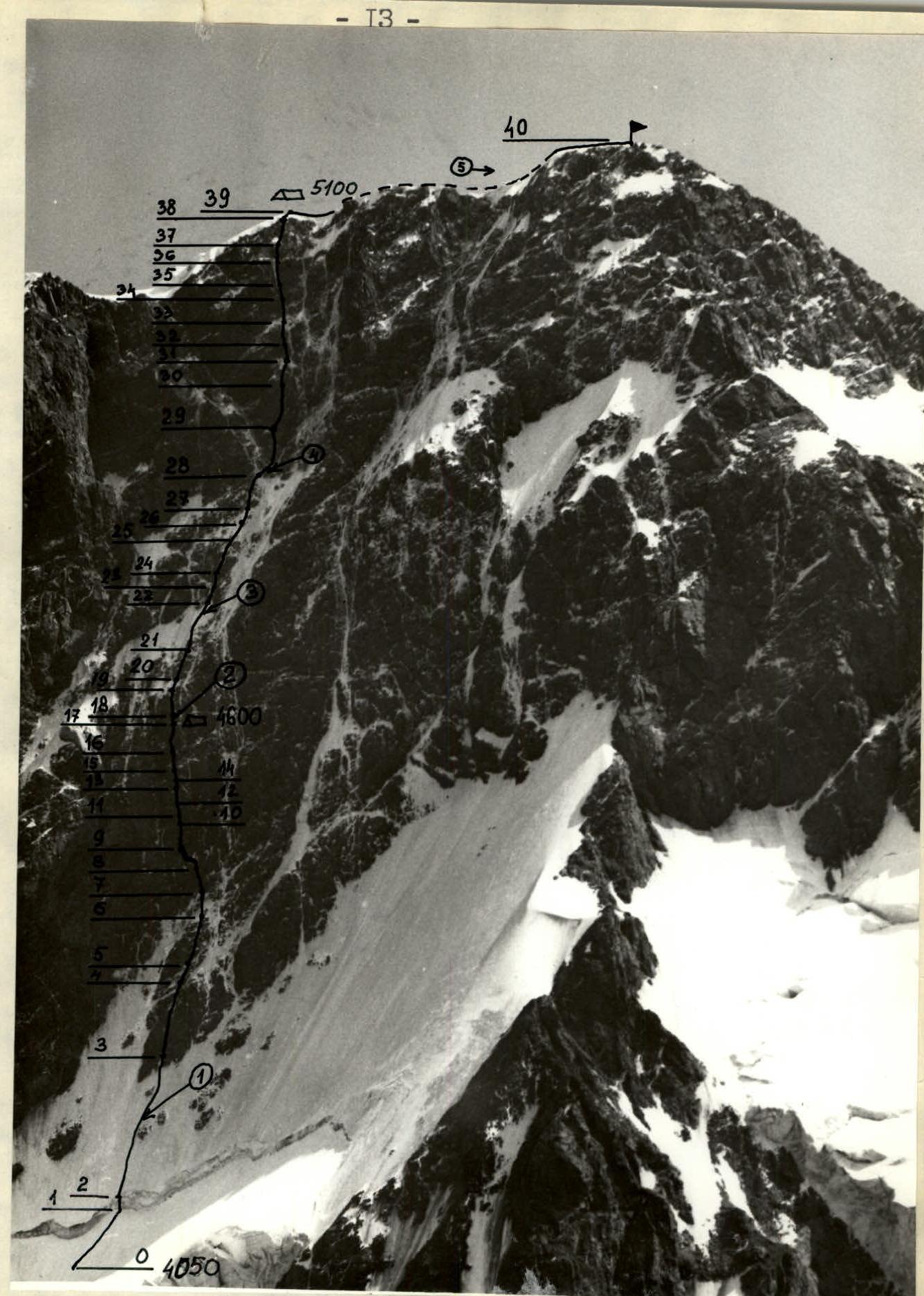
Technical photograph of the route. Taken on August 15, 1984 at 16:00, camera "Lyubitel", distance to the wall about 1.5 km, height 4400 m, shooting point #1.
- 4600 — overnight location indicating height
- ① — shooting location indicating the number of the photograph