Passport
- Technical class.
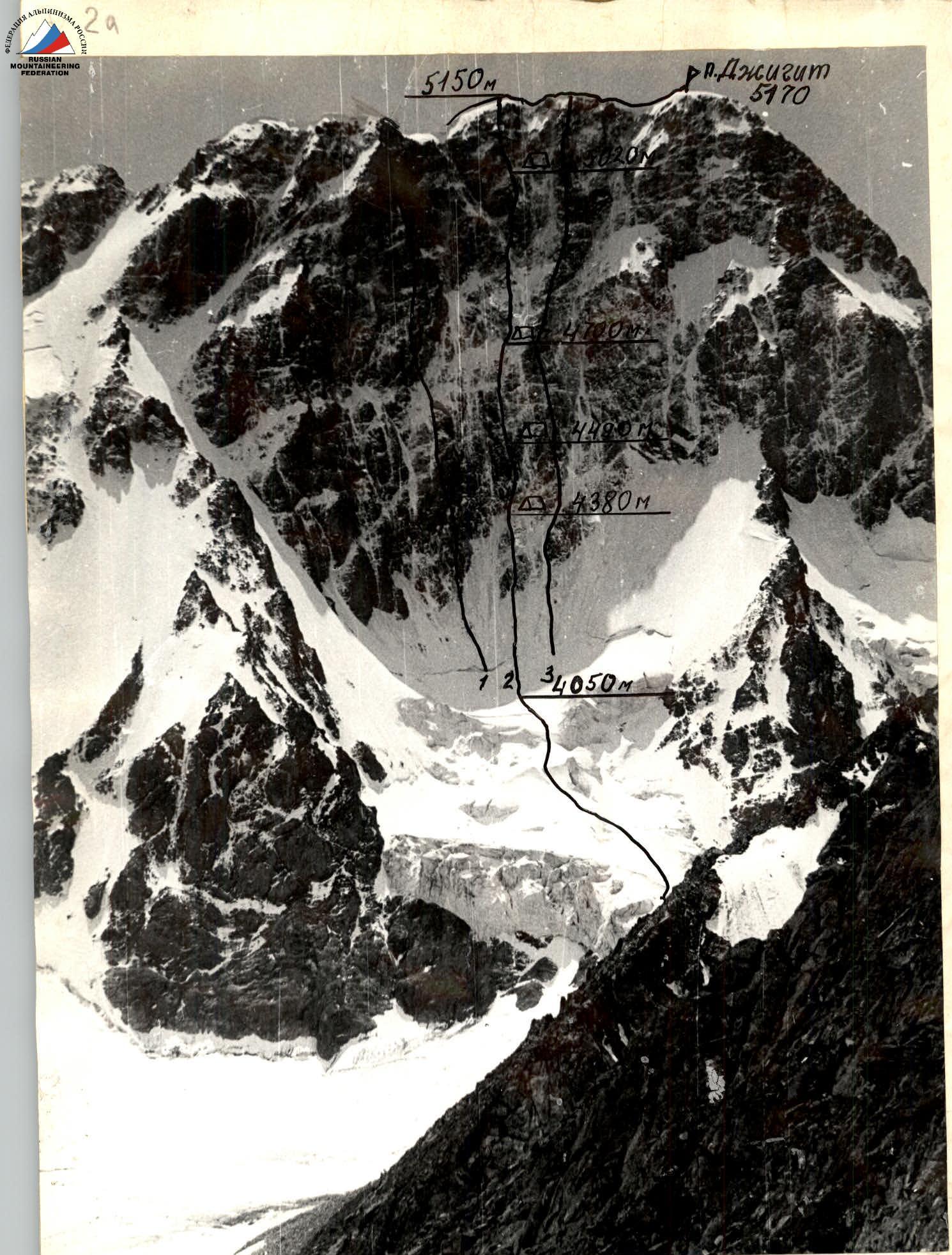
- Terskey Ala-Too, Karakol gorge.
- Peak Jigit, via the center of the north face's kar.
- Proposed 6th category of difficulty, first ascent.
- Elevation gain: 1220 m. Total route length 1565 m, length of sections with 5–6 category of difficulty 715 m.
- Pitons hammered in:
| Category | Hammered in | Left behind |
|---|---|---|
| Rock | 132 | 37 |
| Bolt | 1 | |
| Chocks | 101 | 64 |
| Ice screws | 44 | 6 |
- Climbing hours: 60, days: 5.
- Overnights: 1 — sitting, on an ice ledge; 2, 4 — hanging; 3 — sitting on a snow-ice ledge.
- Team members: Vakurin V.V. — leader, Candidate for Master of Sports; Darmin E.N. — participant, Candidate for Master of Sports; Danichkin A.M. — participant, Candidate for Master of Sports; Shepak S.V. — participant, Candidate for Master of Sports.
- Coach: Boshman V.F.
- Departure to the route: August 11, 1983, summit — August 15, summit day, descent — August 16, 1983.
1st place — Sharashenidze route–6 cat. diff., 1st place in the technical class of the USSR Championship 1976; 2nd place — team of recreation center "Ala-Too", led by Vakurin; 3rd place — Slesova route–6 cat. diff., 1st place in the technical class of the USSR Championship 1975.
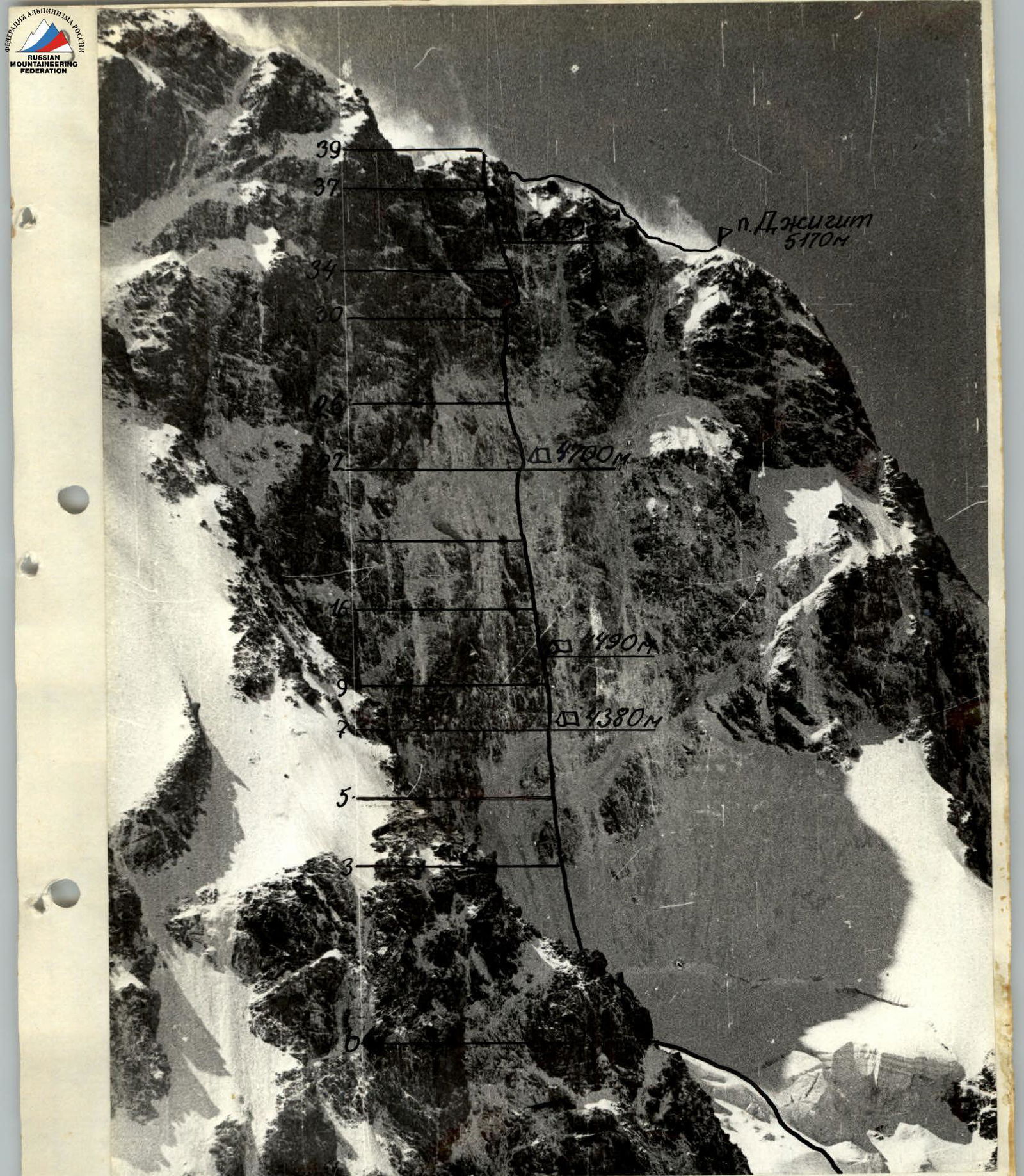
Taken on August 13, 1983, 13:00; lens: "Helios-44", focal length — 58 mm, 2000 m to the object, camera height — 3600 m.
Route profile from the left. Ω — overnight stays. Taken on August 9, 1983, 11:00. Lens "Helios-44", focal length — 50 mm. Camera position #2, height — 3600 m, distance to the wall — 1000 m. The route profile from the left can only be captured from the Sharashenidze route. In the 1983 season, the route was not completed. The route profile from the right can only be captured from the Slesova route.
Tactical Actions
Team
Throughout the ascent, the team operated on a double rope. The scheme was as follows — the first climber ascended on a double rope, securing one rope and using the second as a safety line for the climber below. Since the group had 4 ropes, all participants moved with top-rope protection. The last climber's rope was pulled through.
The pendulum movements of the last climber were particularly challenging. To mitigate this, pitons with loops were left behind. The last climber moved on double ropes with top-rope protection, even if they were pulled through.
Before the ascent, the team had chosen the line of movement. During the climb, there were no deviations from the chosen route. The route was logical from start to finish. In the lower part, it was a wall for all three routes, separated by couloirs.
The team was fully interchangeable, but there was a certain specialization. When working on the route, three participants used ice axes from the same ice axe. (In case of need, each could organize additional belay points.)
The change of lead climber was planned in advance as part of the tactical plan:
- Sections R0–R6 were worked by Shepak S.
- Section R5–R19 on the bastion was worked by Darmin E. (On August 2, he processed 40 m and on August 12, another 40 m were processed.)
- Then, on August 13 and 14, Vakurin worked at the front — sections R20–R31.
- Sections R31–R40 were led by Shepak S.
The team had 3 backpacks on the route:
- The first climber always went without a backpack.
- The last climber had a lightened backpack.
- The second climber always carried part of the climbing gear.
Backpacks were not pulled up for 40 m. The following arrangement was made — the belay line went to the backpack, and then to the climber, i.e., the belayer pulled the backpack up.
During the ascent, there were no group stops for lunch or rest planned. Each team member had an individual lunch pack. The first climber worked with maximum efficiency, as the group's speed on such a route depended solely on the first climber's work.
The route was not rockfall-prone, as all loose rocks were frozen in ice. It was desirable to pass the middle part of the route between the 2nd and 3rd overnight stays before August 15, as from 15:00 onwards, the upper part of the bastion was exposed to the sun, and rockfall was possible.
The team did not stretch out more than 80 m during the ascent. On hazardous sections where rock or ice fall was possible, only one climber moved ahead, while the others observed. A descent in case of unforeseen circumstances was possible.
Overnight stay locations were chosen based on observations from below:
- 1st, 2nd, 3rd overnight stays were protected by rock overhangs.
- 4th overnight stay — on a rocky counterfort.
During overnight stays, everyone wore helmets and was on self-arrest. The overnight stay areas were secured with double rope belays.
Before departing on the route, the team was particularly concerned about rockfall hazards on a certain section. The group developed a specific tactic for passing this section. During the ascent, no spontaneously falling rocks were observed.
A problematic task was navigating the highest category of difficulty in crampons. This affected the time taken by the first climber to pass the lower bastion (2–3 hours to pass one rope length).
The route lacked suitable overnight stay locations, i.e., there was no opportunity for the team to fully rest. Daily, between 15:00–16:00, the weather deteriorated in the gorge, and for 2–3 hours, graupel fell along the wall. The team had to work in such weather conditions, as individual overnight stays were not planned.
The team received accurate and complete information through observers stationed below the wall. Communication was maintained via "Vitalk" radio station.
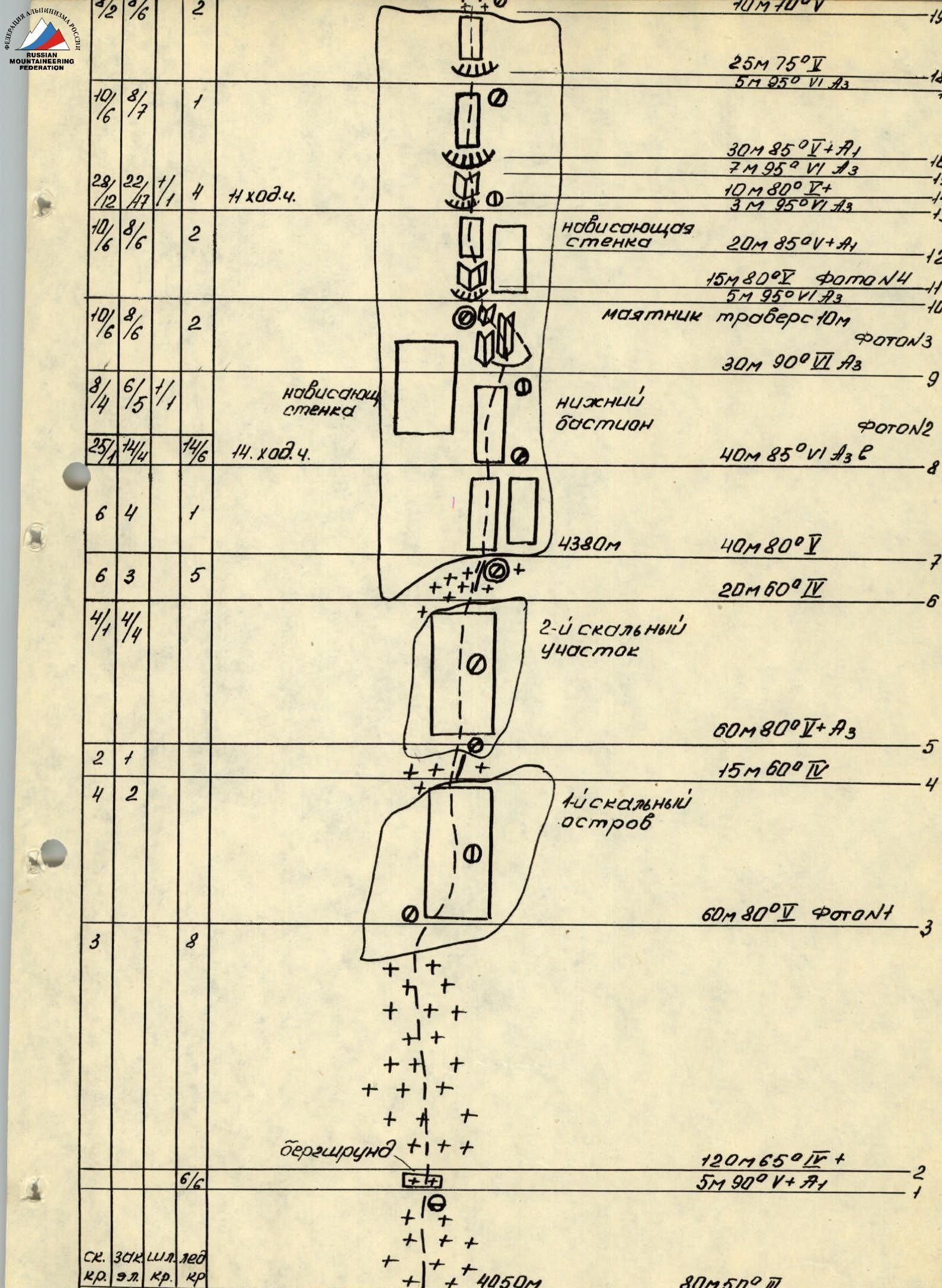
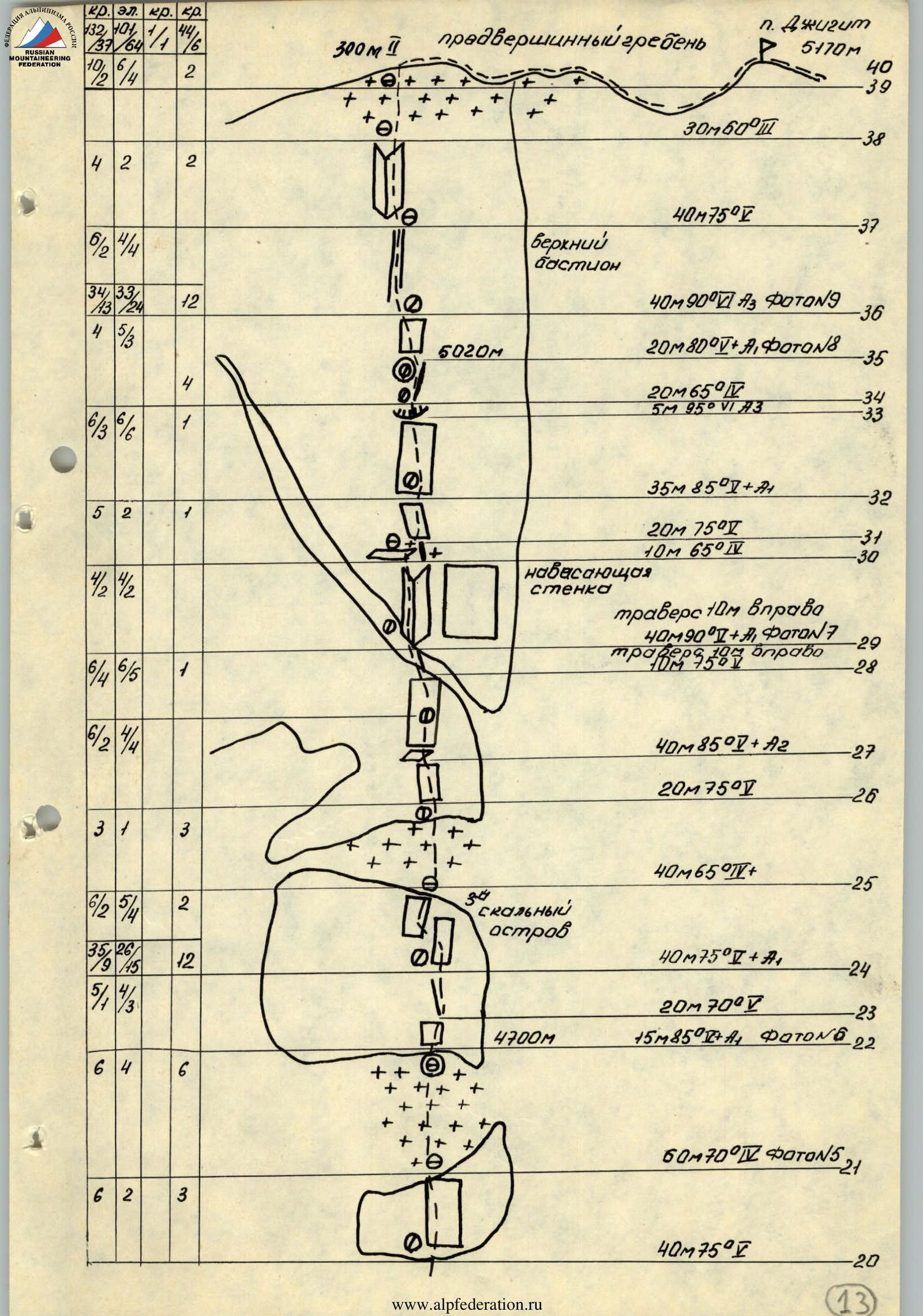
120 m 85° V+
5 m 90° V+ A1 80 m 80° V ФОТОN3 60 m 80° V ФОТОN3 120 m 85° V ФОТОN3
Route Description by Sections
R0–R1 Mixed snow and ice ascent from the adjacent snow patch to the bergschrund.
R1–R2 Bergschrund — 2–3 m wide. The upper boundary has a snow cornice, complicating passage. Passed with the aid of ice axes and ice axe.
R2–R3 Section of moderate steepness.
R3–R4 and R5–R6. Two rocky outcrops. These are two steep rock faces, frozen in ice and covered in snow. All loose rocks and cracks are filled with ice. Convenient belay points are scarce.
R4–R5. Ice ridge with embedded rocks.
R7–R19 — lower bastion.
General characteristic — a very steep, monolithic wall, with a steepness ranging from 80 to 95°, entirely frozen in ice and covered in snow. To find cracks and holds, it is necessary to chip away the ice: the bastion is 250 m long. Passing the entire bastion is a challenging task; it is complicated by daily snowfalls in the afternoon. There are no convenient ledges for overnight stays, belay points, or rest areas on the bastion. R8–R9 Monolithic rock face with very few cracks. The upper part has an overhang. Very strenuous climbing using ladders. R9–R10 Rock face, which took the first climber 3.5 hours to pass. The problem was that a direct ascent was impossible — (overhanging monolithic wall; to the right — a couloir separating it from the Slesova route, to the left — a monolithic corner). Passage of this section is only possible using a pendulum, hindered by the scarcity of cracks. For the rest of the team, a suspended traverse was organized. Movement was complicated by snow in the form of graupel, which flows down the entire wall during bad weather. From below, the overhanging walls appear as two black rock outcrops, which do not lighten even after Karakol snowfalls. On section R10, a hanging overnight stay in a hammock is possible. This is the top of the inner corner, ending in a 40–50 m ledge. R10–R11 Overhanging wall. Passage is only possible using ladders. R11–R13 Inner corner, with a 5–10 cm ice crust. Cracks are virtually absent. Organization of intermediate belays using ice screws. In the upper part — an overhanging wall. Belay organization under a rock overhang. To the right and left of the inner corner, from below, two snow patches are visible — resembling convenient platforms. These are two steep 50–60° rock faces, covered in snow. R13–R16 Series of overhanging ledges. It took the first climber 2.5–3 hours to pass 20 meters. Very strenuous climbing using ladders. R16–R19 Rock face, frozen in ice, ending in a rock overhang. Passage of this overhang is only possible using chockstones like "cheque". R20–R21 Bend of the lower bastion. In the upper part, there is a convenient belay point. R21–R22 Ice and snow slope, abutting an overhanging wall. It is possible to organize the only sitting overnight stay on the entire route. R22–R25 Third rocky outcrop. This is a series of rock faces resembling "ram's foreheads" with few cracks and holds, covered in snow and frozen in ice. R25–R26 Snow and ice slope. R26–R28 Rock face, ending in a steep ledge, frozen in ice and covered in snow. From below, the ledge appears like a couloir. The ledge ends in overhangs in the upper part. R29–R38 Upper bastion. General characteristic — a wall with a large-block structure. In the lower and middle parts, very steep, becoming gentler in the upper part. The rocks are less frozen in ice. There are no platforms for overnight stays. R29–R30 Inner corner, frozen in ice. Very strenuous climbing using artificial holds. R30–R31 Rock ledge, composed of light granite rocks. From below, it appears as a clear light stripe. R31–R34 Rock faces, covered in snow. Passed by free climbing. Exit to an overhanging ledge — feather-like. R34–R36 Snow ridge and exit to a rock ledge. Traverse to the left. R36–R38 Inner corner. With very strenuous climbing. The rocks are dry. During the passage, for the first time on the entire route, crampons were removed. R37–R38 Rocks of moderate difficulty and exit to the mixed snow and ice ascent of the main ridge.

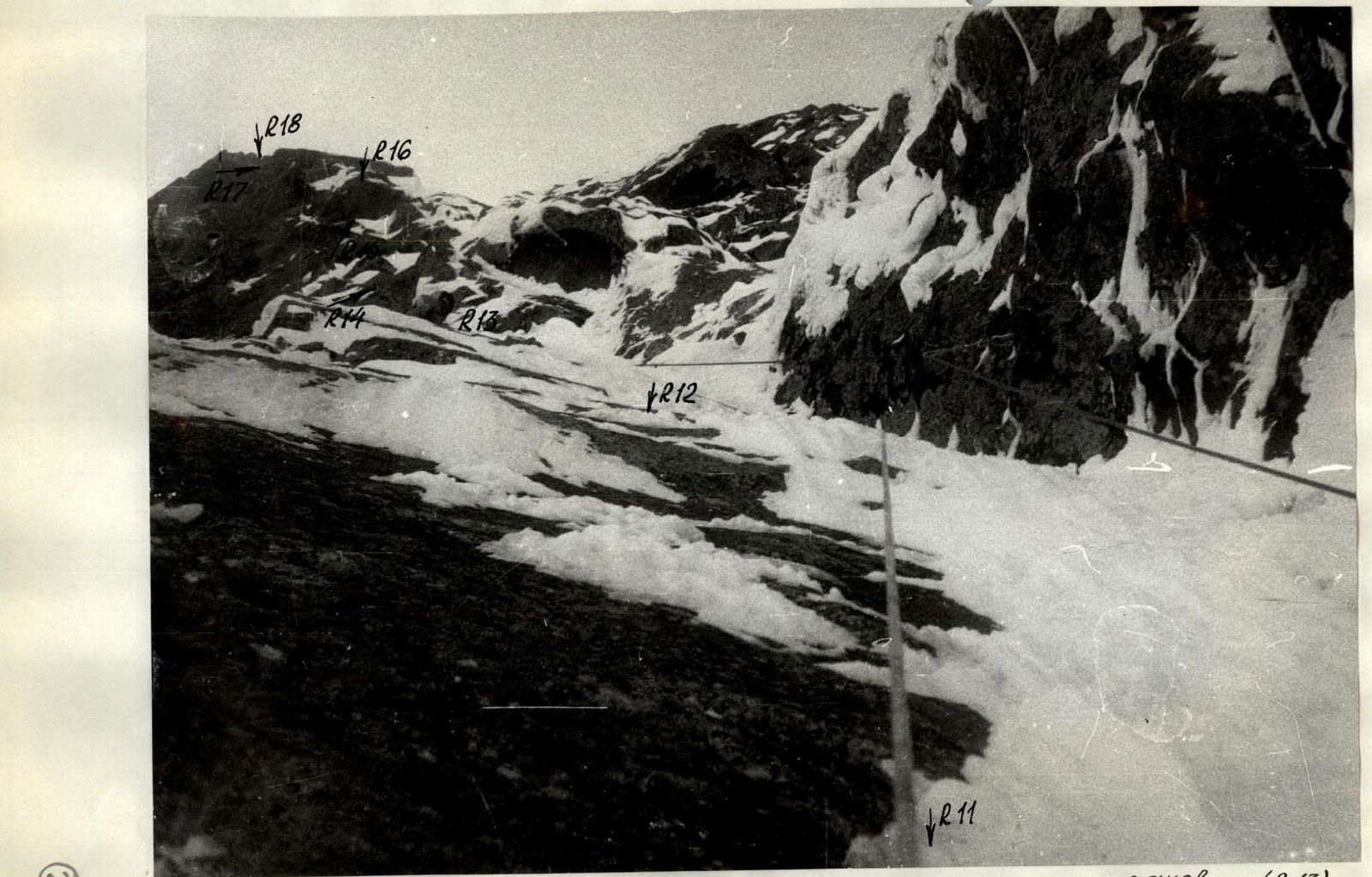
Photo #4. Sections R11–R18. Organization of rope protection and belay points (R13). Taken on August 13, 1983, 9:30; lens "Industar-50", focal length — 50 mm, camera position #6 (R11).