Passport
- Technical class
- Central Tien-Shan, Karakol gorge
- Peak Jigit via bastions of the North face
- 5B category of difficulty — possibly 3rd ascent
- Height difference: 1270 m, length — 1400 m
Length of the complex section — 1000 m. Average steepness of the main part of the route (bergschrund — ridge) 70° (4000–5050 m)
- Pitons left on the route — 0 pcs.
Used previously hammered pitons and not removed — 1 pc.
- Team's travel hours: 32 h and 3 days
- Overnights: 1st on a ridge, built from stones and cut into the ice, 2nd — made from wet snow on the main ridge
- Leader: Ryabukhin S.A. CMS
Members: Ilyin I.V. CMS 3rd category, Kichin V.E. CMS 1st category, Nikokoshev E.V. CMS 10. Coach: Ilyin I.V. CMS 3rd category. 11. Departure to the route: July 22, 1993
Summit: July 24, 1993
Return: July 24, 1993
12. Organization: Kemerovo Regional Sports Committee
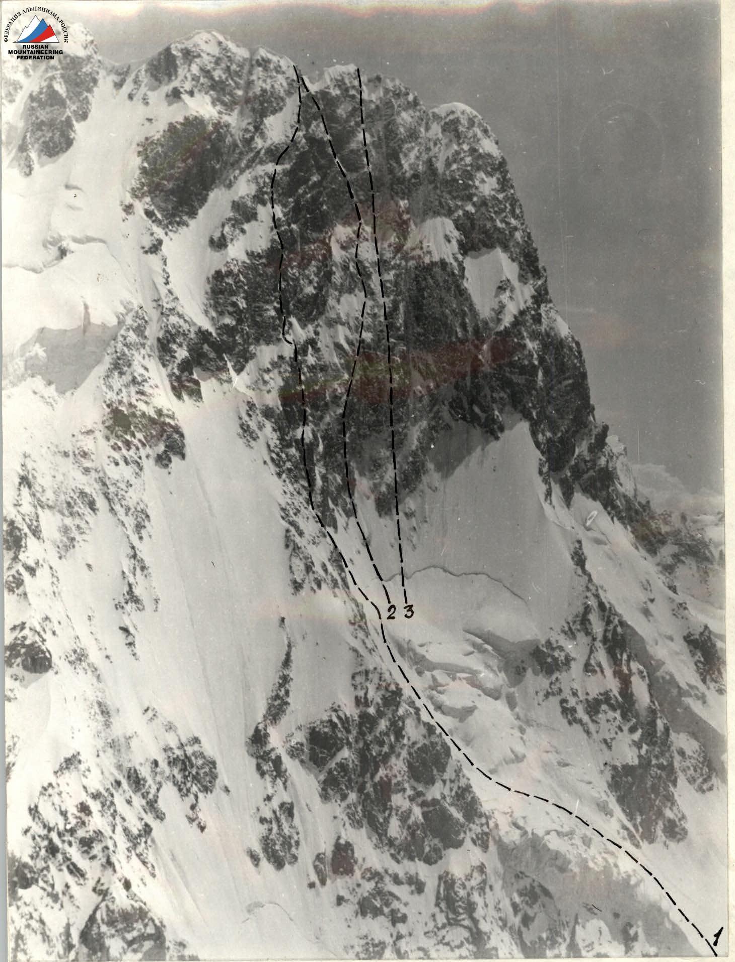
Photo # 1. General photo of the summit. Taken in July 1989 from a helicopter, lens T22 4.5/75 mm.
- Route of Zhurzdin via bastions of the North face 5B category of difficulty.
- Route of Sharshanidze via the triangle of the North face 6A category of difficulty.
- Route of Vakurin via the center of the North face couloir 6B category of difficulty.
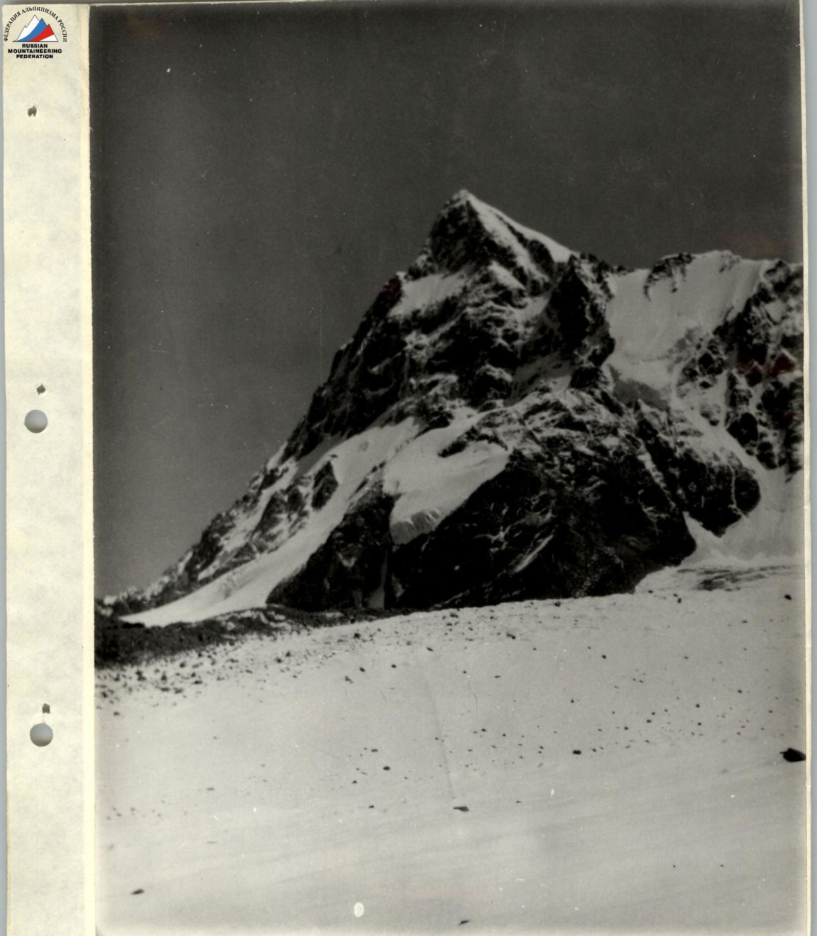
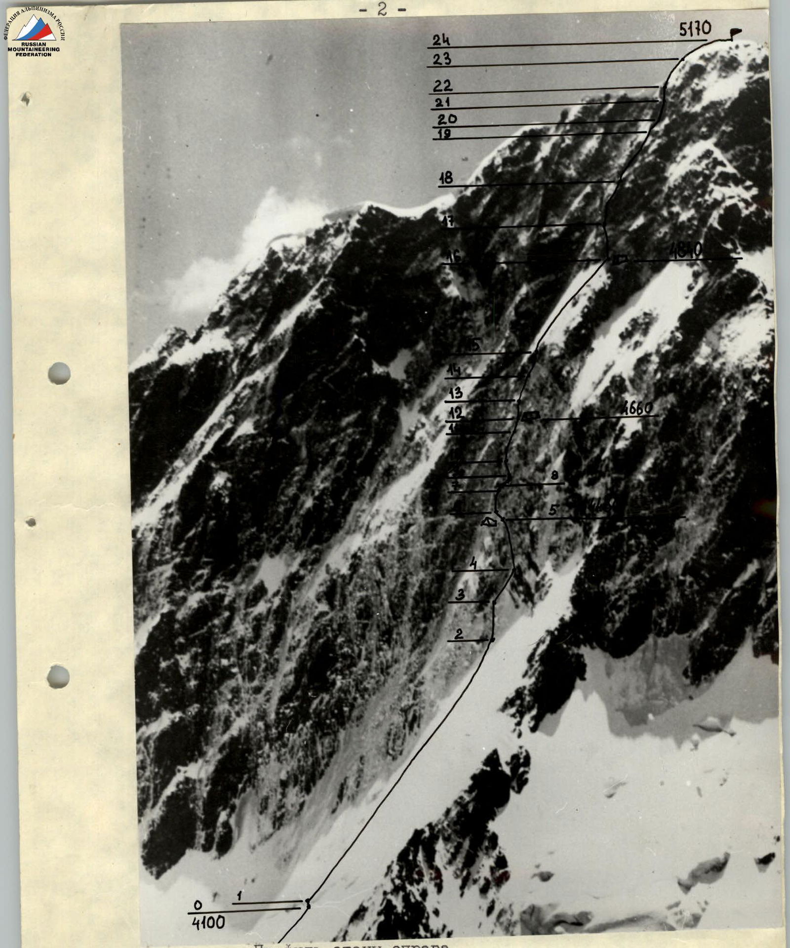
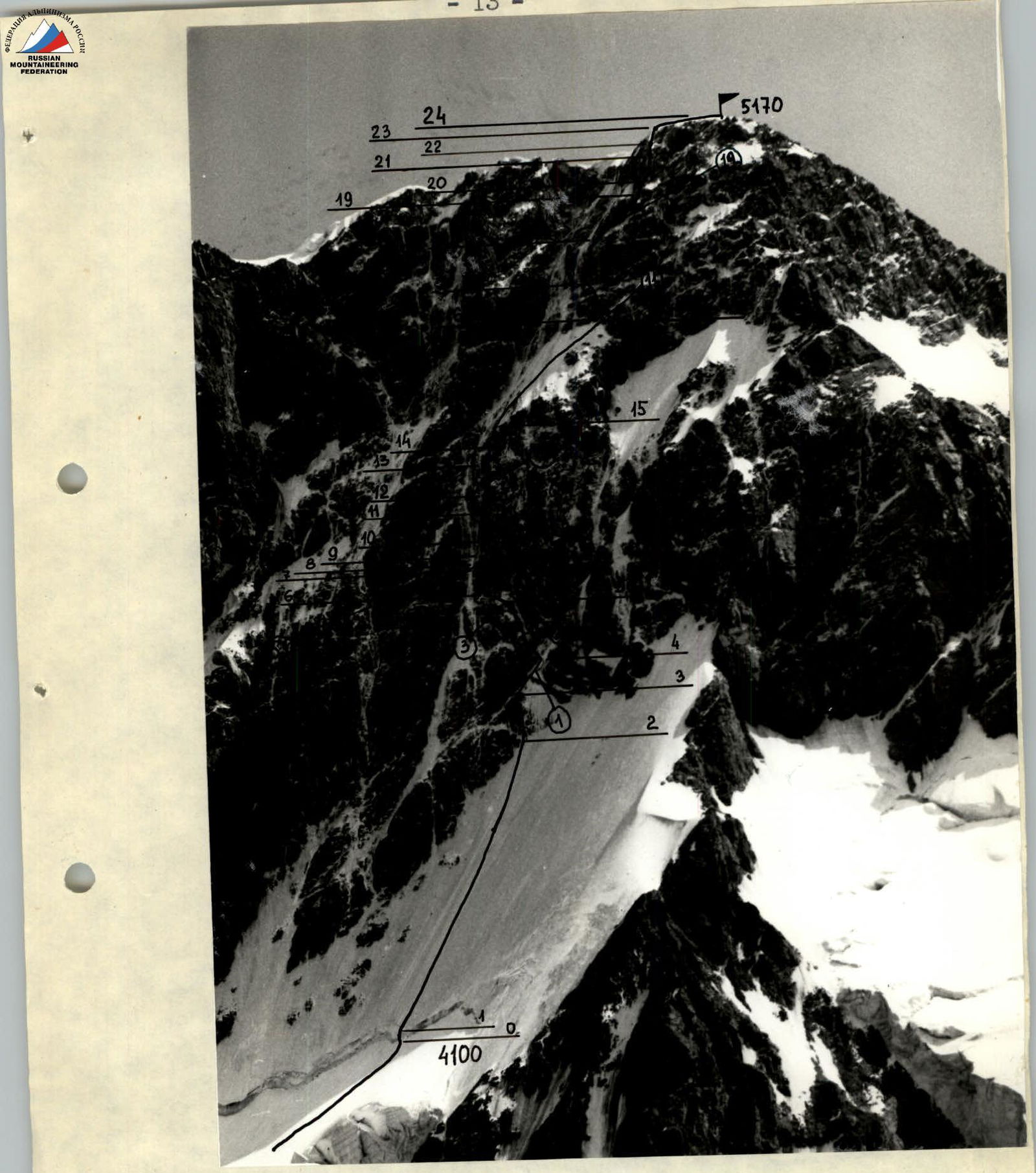
Photo # 2. Route profile from the right. Taken in July 1991 from the V. Ontor glacier, point # 1, lens T22 4.5/75 mm. Team's route.
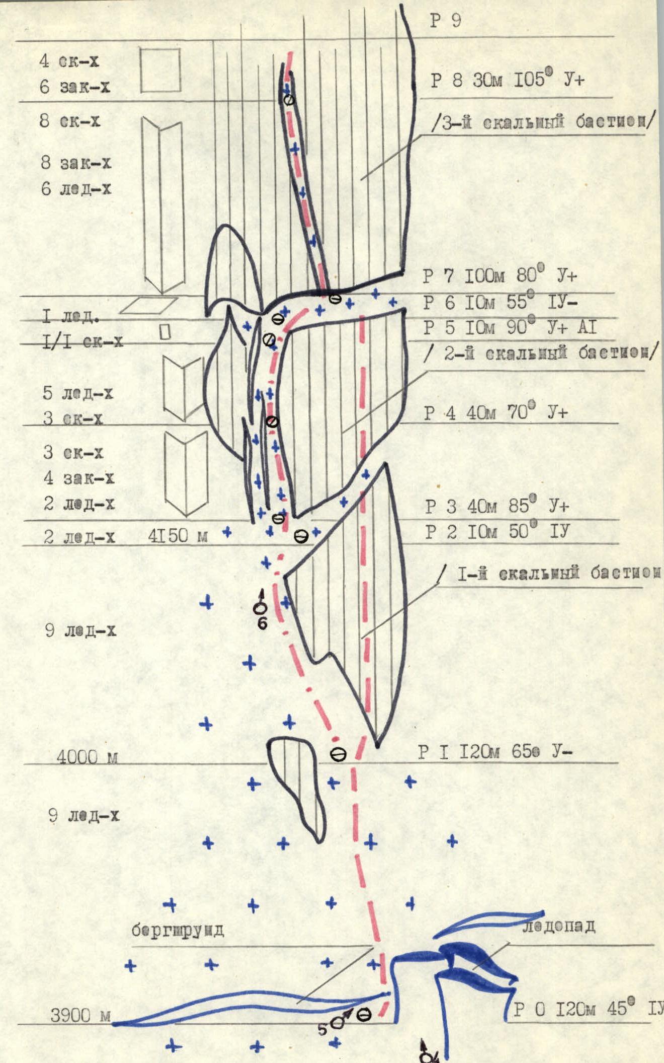
Photo # 3. Route profile from the left. Taken in July 1989 from a helicopter, lens T22 4.5/75 mm. Team's route.
The tactical plan was based on completing the route without prior daytime processing. Overnights were planned to be organized in a tent with the whole group in a lying position on section R10 (see report) and on the main ridge under the summit. On July 22, the group arrived at section R10 at 14:00 and waited out a thunderstorm. During this time, a hot meal was organized. After the storm passed, two options for the group's movement were discussed: 1st — passing the 4th bastion with the organization of a sitting overnight on it, 2nd — overnight on section R10 with processing of the 4th bastion. They settled on the latter; the Ryabukhin — Kichin pair fixed 4 ropes on the bastion, and the Ilyin — Nikokoshev pair organized an overnight stay and prepared dinner. On July 23, bad weather continued throughout the day: wet snow, wind, visibility 20–30 m. The group decided to start moving along the fixed ropes. Passing unprocessed sections became more complicated. The leader changed practically after every rope length of climbing. On this day, food was organized with dry snacks during belays, as it was too cold to stop. After reaching the main ridge, they decided to organize an overnight stay in a depression to shelter from the wind. The team, very wet and tired, used the remaining dry clothes and sleeping bags for the overnight stay. The night was cold. The morning of July 24 arrived at 4:00. Preparing a hot meal, beating and thawing frozen clothes took 2 hours, after which the 1st rope started moving, followed by the 2nd.
Rock bastions were climbed on a double rope in pairs: the first rope processed the section and left one rope as a handrail, and pitons from the second rope; the first person in the second rope climbed the section using the handrail with bottom belay, the last person — using the handrail with top belay, removing pitons.
All equipment was divided into two equal sets, which were with the first rope (after finishing the 1st set, the second participant handed the leader the 2nd set). This allowed the first rope not to depend on the second in waiting for equipment. The first person moved without a backpack, the last — with a lightened one.
For movement along handrails, jammers and Jumars of various types were used. Equipment used on the route was manufactured by both domestic and foreign companies, fully complying with established standards.
Snow and ice sections were climbed by individual ropes using left ice screws.
The main work on rocks was done by Ryabukhin, on ice — by Nikokoshev.
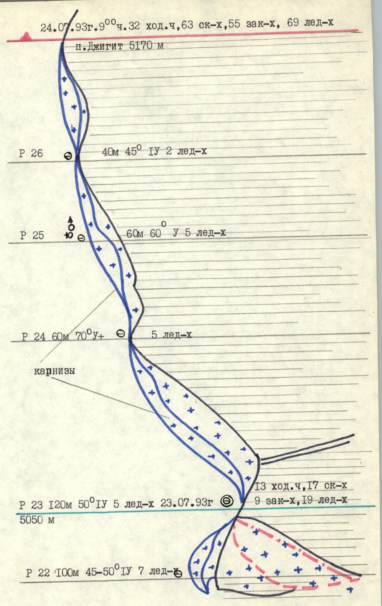
During the ascent, there was a slight (about 50 m in height) deviation from the tactical plan due to bad weather. The organization of the 2nd overnight stay was planned under the very summit (section R26), but during the day, the team got very wet and spent a lot of energy; the danger of a thunderstorm at night and strong wind on the ridge literally forced the group to stop in a depression (section R22).
Observation of the team's actions was carried out from the "Brigantina" camp of the rescue team and from overnights under the Kel'bor pass by observers. On July 22 — using a monocular and radios, on July 23–24 — radios.
List of food products
| № | Product | Weight |
|---|---|---|
| 1. | Bread | 2 kg |
| 2. | Canned meat | 3 kg |
| 3. | Canned fish | 1 kg |
| 4. | Smoked sausage | 0.5 kg |
| 5. | Lard | 0.5 kg |
| 6. | Tea | 50 g |
| 7. | Sugar | 0.5 kg |
| 8. | "Caramel" candies | 0.5 kg |
| 9. | Dried fruits | |
| 10. | Condensed milk | 1 kg |
| 11. | Honey | 0.2 kg |
| 12. | Chicken broth | 10 g (conc.) |
| Noodles | 100 g | |
| 13. | Nuts | 100 g |
| 14. | Chocolate | 100 g |
| 15. | Concentrated drink | 100 g |
| 16. | Salt | 50 g |
| 17. | Packet soup | 100 g (conc.) |
| Total weight | 10 kg 100 g | |
|
Diagram in UIAA symbols. Scale 1 : 20000
July 24, 1993, 9:00, 32 travel hours, 63 rock hours, 55 fixed hours, 69 ice hours
Description of the route by sections
The route can be conditionally divided into three parts:
- passing the icefall and approach under the first bastion
- passing the wall, which in turn is divided into four bastions
- exit to the main ridge and summit The approach under the 1st rock bastion does not present technical difficulty; crevices on the icefall are densely filled with snow. The bergschrund is held by bridges, over which it is overcome. Ice is covered with firn.
The main technical complexity of the route is made up by the bastions of the North face: height difference 700 m, average steepness — 80°, difficulty — 5B–6B category of difficulty. Abundant snowfall and rain before the group's departure to the route significantly complicated the technical difficulty — rocks are covered with ice and snow; ice is covered with "scales," which complicates movement and organization of belays.
Passing the ridge above the 4th bastion and movement along the main ridge represent significant danger. Wet snowfall throughout the day increased the danger of "board" avalanches. Movement along the ridge is hindered by large snow cornices hanging on both sides.
On July 22, 1993, departure from overnight stays under the wall on the left bank of the Jigit glacier under the Kel'bor pass at 4:00. Passing the icefall in ropes with simultaneous belay; above the bergschrund to the 1st rock bastion simultaneously, belay through an ice axe. For passing the 1st bastion, a variant of bypassing it on the left was chosen with an exit under the gully of the 2nd bastion (section R0–R1). Sections R2–R5 are technically complex: rocks are covered with ice, side walls are monolithic. Exit to an inclined shelf over the bastion through an overhang using PIT for a foot. The first person used an ice axe, ice screws, front teeth of crampons for passing. Belay through pitons, chocks, ice screws.
Passing the 3rd bastion begins with a traverse along an inclined shelf to the right to an internal angle. Movement along the left ice gully is impossible due to constant snow flows. Passing the 3rd bastion (section R7–R9) is significantly hindered by overhanging rocks. Exit to the bastion using PIT, Zaltsbug, sometimes — from piton to piton. Rocks are covered with snow, requiring constant clearing; cracks are filled with ice. Movement in crampons using an ice axe (sometimes handholds were cut).
Over the 3rd bastion is a sharp ice ridge, on the edge of which (rocky exit over the wall) is a control cairn; no notes were found. After improving the weather, a pair processed the 4th bastion (section R11–R16), the second pair prepared a site for an overnight stay.
For an overnight stay, they used an old site, expanding it by cutting into the ice and gluing stones using wet snow. Sections R0–R1 were first passed by Nikokoshev, R2–R16 — by Ryabukhin.
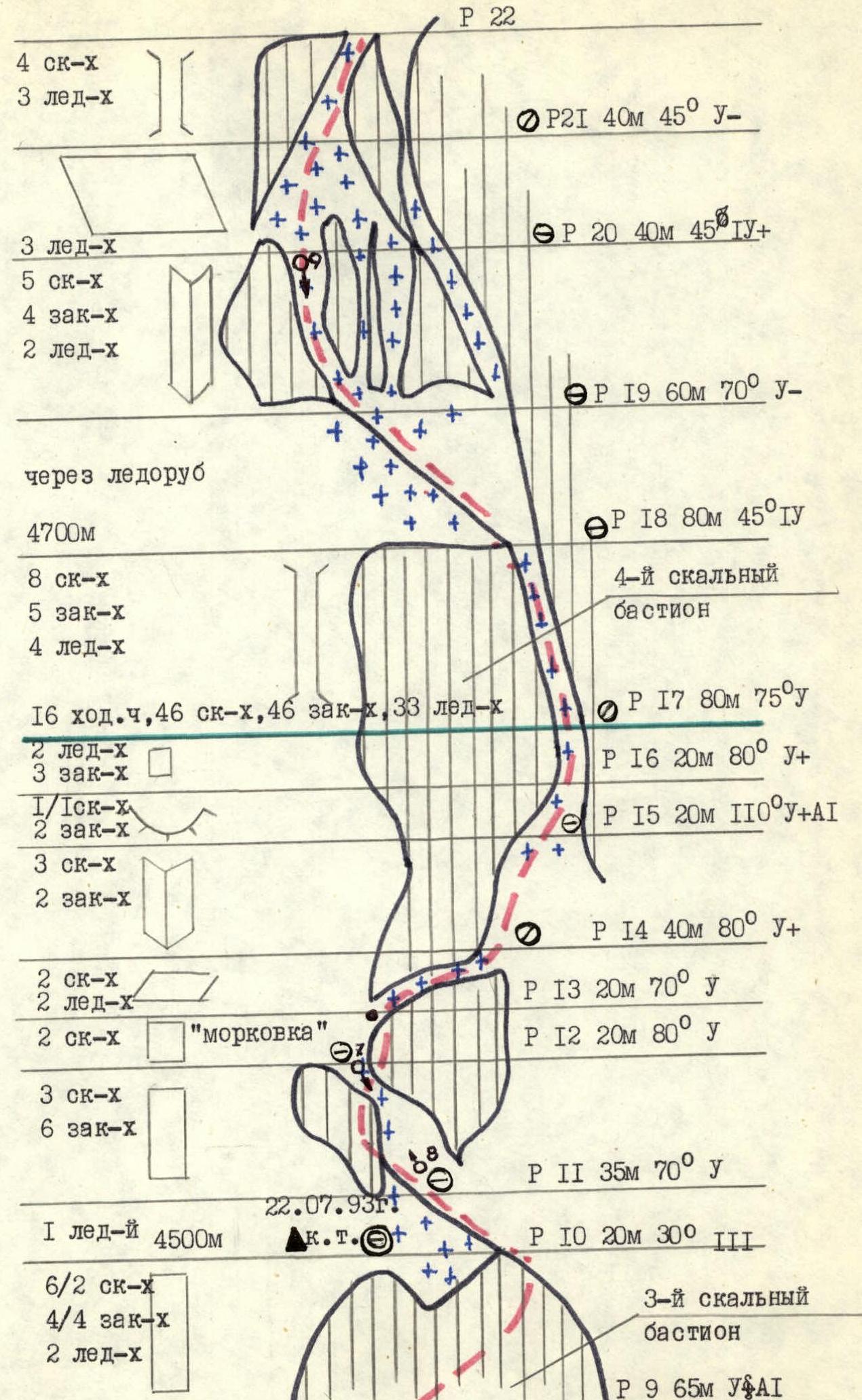
On July 23, 1993, from 6:00, graupel started falling, followed by wet snow. Departure at 8:00, passing the processed section from the evening (4 ropes). Passing a chimney with an exit to the top of the 4th bastion (section R17) was complicated by wet rocks, falling snow, and cold. Approach under the ice-snow ridge through destroyed rocks frozen into ice (sections R18–R21). Constant flow of wet snow. Sometimes handholds were simply dug out, and footholds were made from compacted snow. Hands freeze strongly, sometimes cramped by судорогой; the leader changed after every rope length of climbing. Movement in crampons using an ice axe or ice screws. Belay through pitons, chocks, ice screws, and rocky outcrops. Section R22 was passed straight up along the line of water fall with small traverses at the top. Snow constantly flows; steps had to be tamped from wet snow. Belay alternating through ice screws. Exit to the main ridge to the right of a snow cornice through a snow wall using an ice axe. In a depression of the main ridge, they trampled and made a site for an overnight stay. Strong wind, frost. Sections R17 and R21 were worked on by Ryabukhin, R17–R18 — Nikokoshev, R19 and R22 — Ilyin, R20 — Kichin.
On July 24, 1993, in the morning, there was a strong frost. Due to the cold, they decided to organize an early departure to warm up. The first rope departed at 6:00. Movement along the ridge represents constant maneuvering between cornices (sections R23–R26). Ropes worked independently with alternating belays, sometimes moving simultaneously. Belay through ice screws. Reached the summit at 9:00.
Descent via category 4A along the West ridge in loops, further to the Kel'tor pass. After crossing it, they continued their descent along the Jigit glacier to the location of the rescue team (overnight stays "Brigantina").
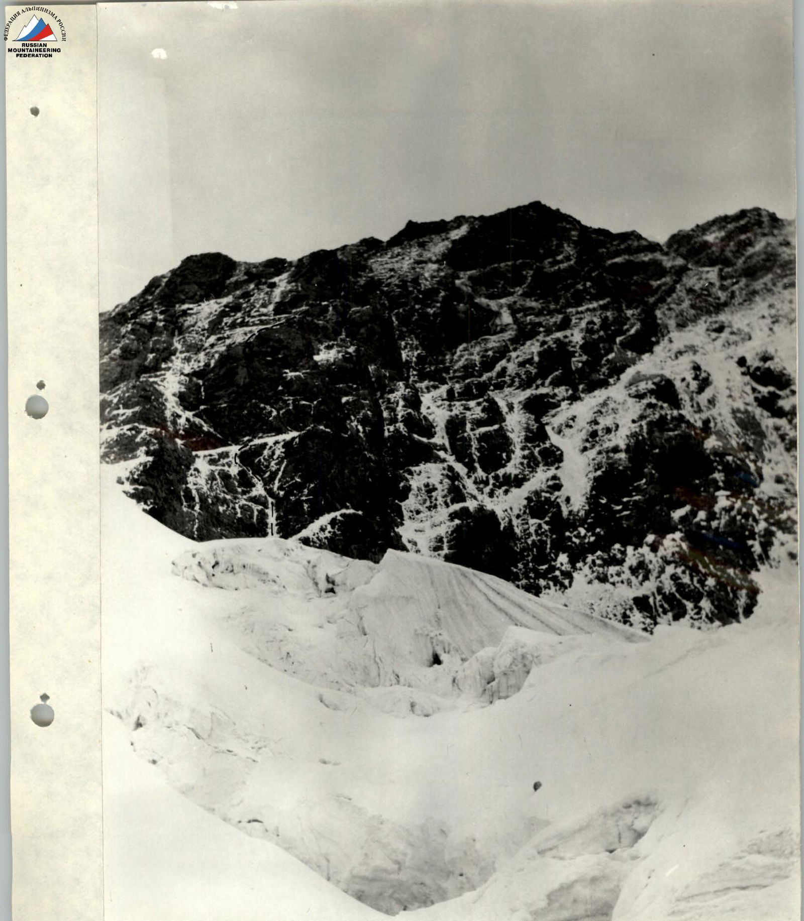
Photo # 6. Bastions of the North face. Team's route, taken on July 22, 1993, from under the icefall, 3900 m, point # 4, lens T22 4.5/75 mm, time — 5:30.

Photo # 8. Sections R3–R9 (2nd and 3rd bastions). Team's route, taken on July 22, 1993, at 6:15, 4100 m, point # 6, lens T22 4.5/75 mm.
Profile of the wall from the right
△ 4480 — overnight stay locations indicating height. Taken on July 27, 1984, at 17:00 after a three-day bad weather, lens "Helios-44", f=50 mm, distance to the wall about 3 km, shooting point # 2.
Tactical actions of the team
The entire route was completed by the team on a double rope according to the following scheme: the first person without a backpack goes out on a double rope, fixes one, and belays the second with the other. The second person climbs with top belay along the handrail on two jammers and carries a free rope. The handrail is fixed by the second person and in the middle of the rope, so that two people can move along one rope at once. In parallel to the handrail, a second rope is fixed, to which the 3rd, 4th, and 5th persons are belayed with a Prusik knot. The last person climbs with top belay along the handrail on two jammers. Pulling backpacks was not planned or done, as it is considered an unnecessary expenditure of strength and time.
The route was chosen, whenever possible, so that participants were not under each other. There were no deviations from the tactical plan and the chosen route. Daytime stops for the whole group for rest or eating were not planned. Everyone was supplied with an individual ration. Tea — flasks of 0.8 l per pair per day were evenly distributed among the group. Hot meals only on overnight stays.
All overnight stays were planned to be sitting or semi-hanging. For arranging sites, ice axes with straight picks were available. On overnight stays, handrails were organized; everyone slept in helmets, on self-belay devices. Although observations showed that the route was not rockfall-dangerous, an early departure was planned and executed on the first day. Overnight stays were chosen under the protection of cornices; rockfall-dangerous sections were passed one by one. Belay and self-belay were organized reliably. In case of unforeseen circumstances, the descent route along the ascent path was studied.
Since rocks on the bastion are covered with ice in many areas, one person in the leading rope worked in rubber boots (Vibram, galoshes), the other was always in crampons with ice equipment. This allowed for quick changing of the leader when changing relief.
On the fourth day of the ascent, on August 21, 1953, at night, a stormy wind blew, and graupel fell. To avoid getting stuck for several days 7 ropes from the ridge, they decided to depart at dawn and pass complex rocks before they were covered with snow, which was done.
Observers had information from us about the group's condition and location every 3 hours via the "Romashka" radio station; they also often listened to our conversations with each other and constantly observed through binoculars.
Route diagram in UIAA symbols
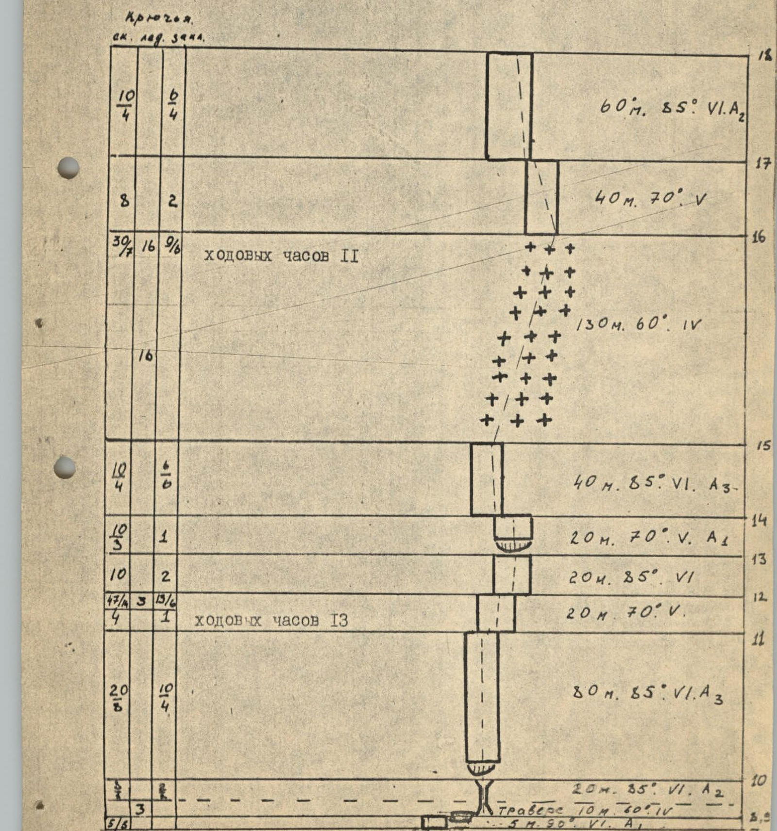
Total travel hours: 45. Total number of pitons: rock 155/43, ice 53/2, chock elements 42/24.

Description of the route by sections
R0–R1 — Bergschrund, width 2–3 m. The upper boundary overhangs, complicating passage. Passed with the help of an ice hammer and two "fi-fi".
R1–R2 — Hard ice with a steepness of 60°. Passed using "fi-fi".
R2–R3 — Ice-covered rocks like "sheep's foreheads". These are steep rock walls heavily covered with ice. Belay through rock and ice pitons. There are live rocks.
R3–R4 — Hard ice with rock inclusions. Due to the large steepness, "fi-fi" are significantly used. There is a danger of dislodging a thawed stone.
R4–R5 — Rocks covered with rime ice like an internal angle. Very complex climbing. When passing this section, ice must be chipped to find suitable cracks for hammering pitons. Often, "fi-fi" were hammered into cracks filled with rime ice.
R5–R6 — 15-meter traverse of rock covered with a thick layer of rime ice. Very complex climbing. A pendulum is possible when the last person moves, so it is necessary to use pitons with loops so that the last person moves along double handrails with subsequent pulling of the handrail rope.
R6–R7 — Monolithic internal angle with ice. There are few holds and cracks. Very complex climbing. Passed using ladders and PIT.
R7–R8 — Vertical five-meter wall. Passed using ladders. Holds have to be chipped out of ice. There are very few cracks.
R8–R9 — Rime ice on rock, steepness about 60°. The complexity of the section is that it starts with heavily smoothed rocks like "sheep's foreheads" and transitions into hard ice. This section ends under a wide internal angle. A pendulum of the last participant is possible.
R9–R10 — Wide 20-meter chimney with smoothed, vertical side walls, ice inside. There are cracks for chocks and pitons. The chimney leads under a cornice. Here is a small site where belay can be organized. Two people can barely fit there.
R10–R11 — After the cornice, passage of which requires ladders, begins a not clearly expressed internal angle, which is one of the key sections of this route. Very complex climbing, few holds, and cracks are often filled with rime ice; rocks are heavily smoothed. Ladders are used for passage. In the upper part, there are live rocks.
R11–R12 — Twenty-meter rock wall. Rocks are covered with ice. In the upper part, there are live rocks that can hit the previous section if participants are not careful. After this section, there is a place where an ice step can be cut for a sitting overnight stay. Control cairn.
R12–R13 — Rock wall. Covered with ice. Ends with a cornice. Ladders are used for passage.
R13–R14 — Rock wall. Rocks are covered with rime ice.
R14–R15 — This is the most complex section of the route. A cornice, and above it, a slit about 10 cm wide, cuts through a vertical wall. The slit is filled with ice and snow. Movement through the slit is possible using chocks — eccentrics and ladders; there are no cracks for hammering pitons here.
R15–R16 — Hard ice, steepness about 60°. In the upper part, there is a place for organizing a semi-hanging overnight stay.
R16–R17 — Section of ice-covered rocks. Holds have to be chipped out.
R17–R18 — Section of steep, heavily destroyed rocks. In some places, rocks overhang. Very complex climbing. There is a danger of dislodging live rocks.
R18–R19 — Rocky ridge with ice sections.
R19–R20 — Strong, monolithic rocks with practically no ice. Small holds. In the middle part, there is a cornice, which is passed using PIT.
R20–R21 — Dry, strong rocks with small holds.
R21–R22 — Uncomplicated snow and ice slope.
R22–R23 — Wide snow ridge, to the left — cornices.
Technical photography of the route
Taken on August 15, 1984, at 16:00, camera "Lubitel'", distance to the wall about 1.5 km, height 4400 m, shooting point # 1. △ 4480 — overnight stay location indicating height (1) — shooting location indicating photo number
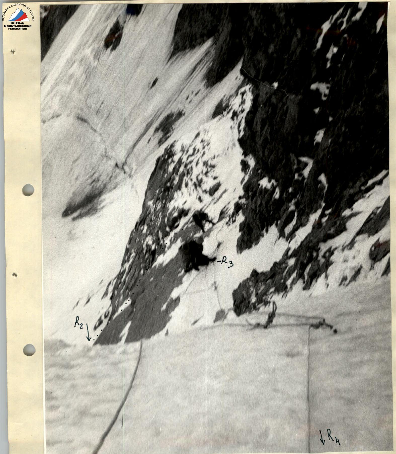
Photo # 1. Section R3–R4. Taken from point # 1 on August 18, 1984, at 11:00.
Note:
- This and subsequent photos were taken with a "Smena" camera.
- Focal length = 38 mm.
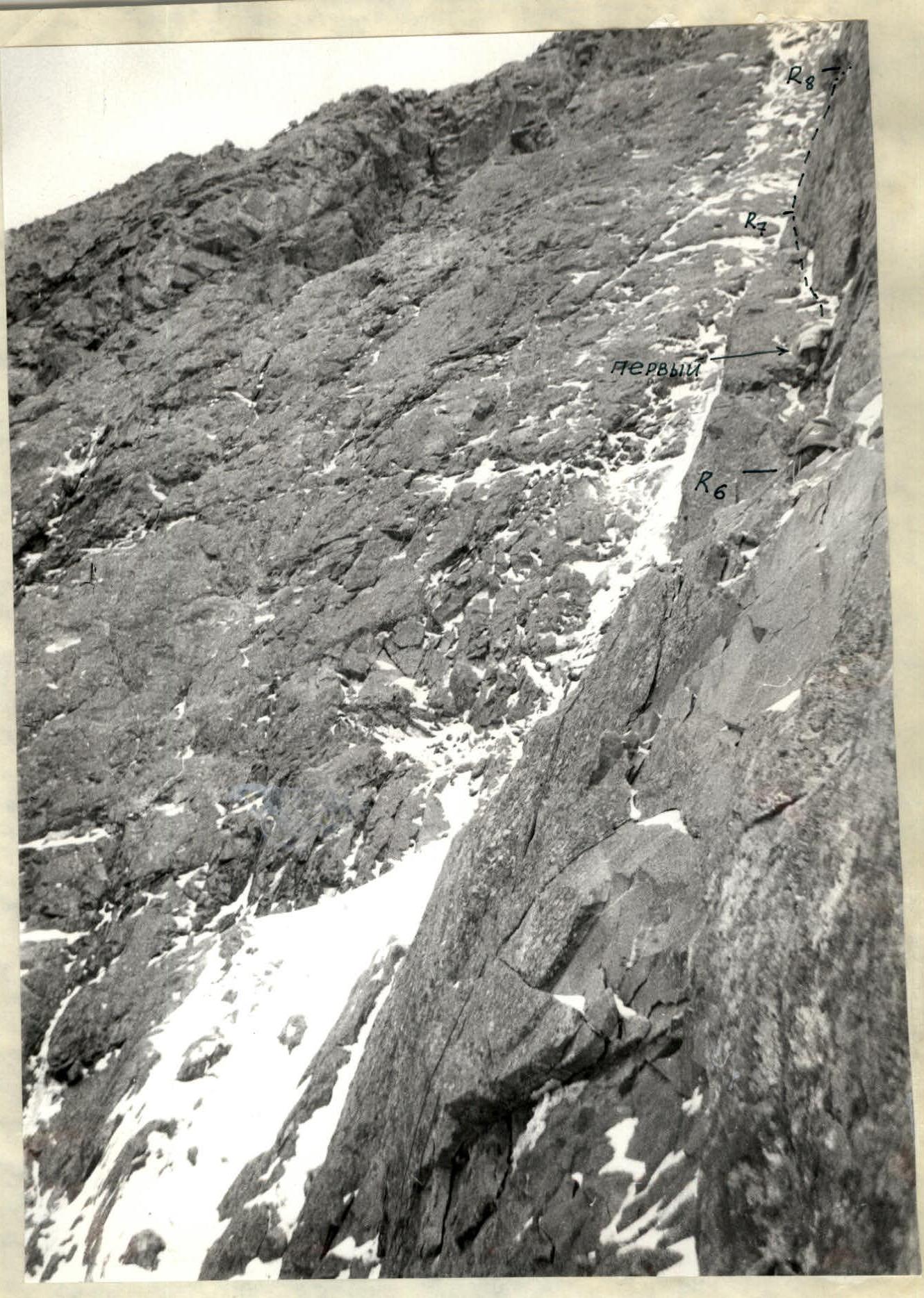
Photo # 3. Section R6–R7. Processing the section. Taken from point # 3 on August 18, 1984, at 19:30.
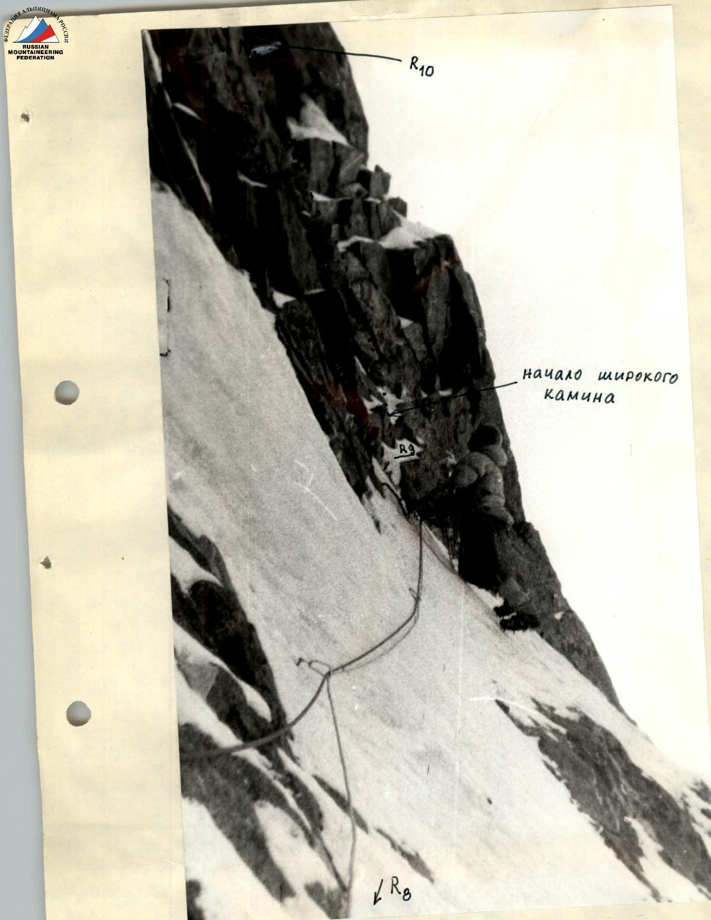
Photo # 5. Section R8–R9. Ice traverse. Taken from point # 5 on August 19, 1984, at 13:00.
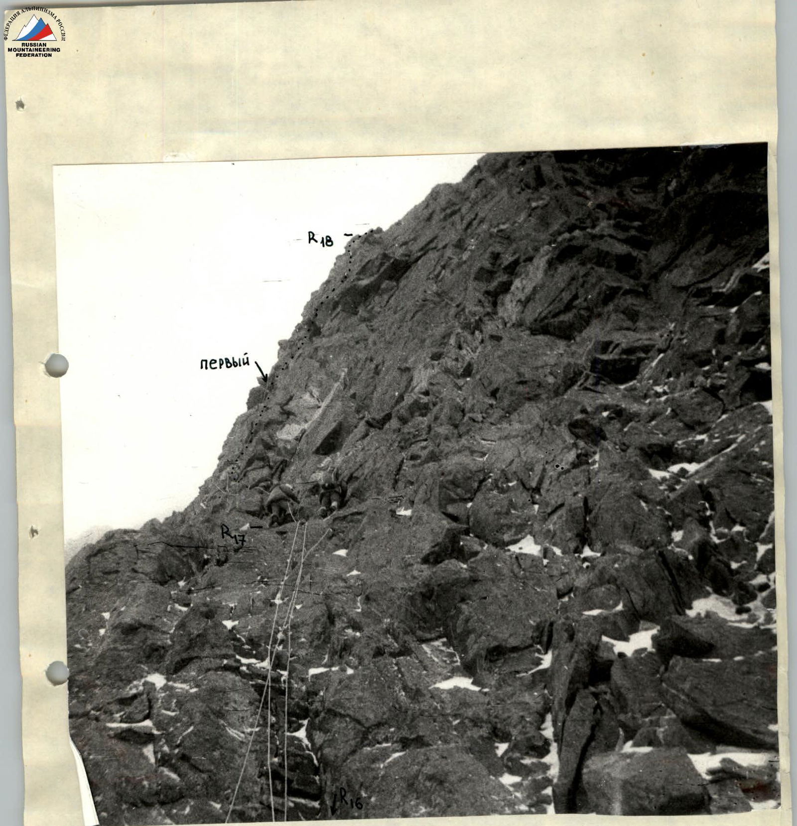
Photo # 13. Section R17–R18. First rope after the third overnight stay. Taken from point # 11 on August 21, 1984, at 8:30.