Ascent Passport
Climbing Area: technical Range: Central Tian-Shan, Terskey Ala-Too Range Peak, its height, ascent route: Jigit, 5th category, via the North face Proposed difficulty category: 5B Route characteristics: height difference: 1500 m average steepness: 70° length of sections: 5–6 cat. diff., 770 m Pitons driven:
| For belay | For I.T.O. | |
|---|---|---|
| rock | 105 | 18 |
| ice | 95 | 8 |
| bolt | – | – |
| Number of climbing hours: 36.5 | ||
| Number of bivouacs and their characteristics: 4; 1, 2 — sitting, 3 — semi-reclining, 4 — lying | ||
| Participants' surname, name, and patronymic: |
- Boshman Verner Frantsevich — CMS
- Usmanov Stanislav Fedorovich — CMS
Team coach: Slepukhin Evgeny Filippovich
Date of departure and return: July 26, 1978 — July 30, 1978
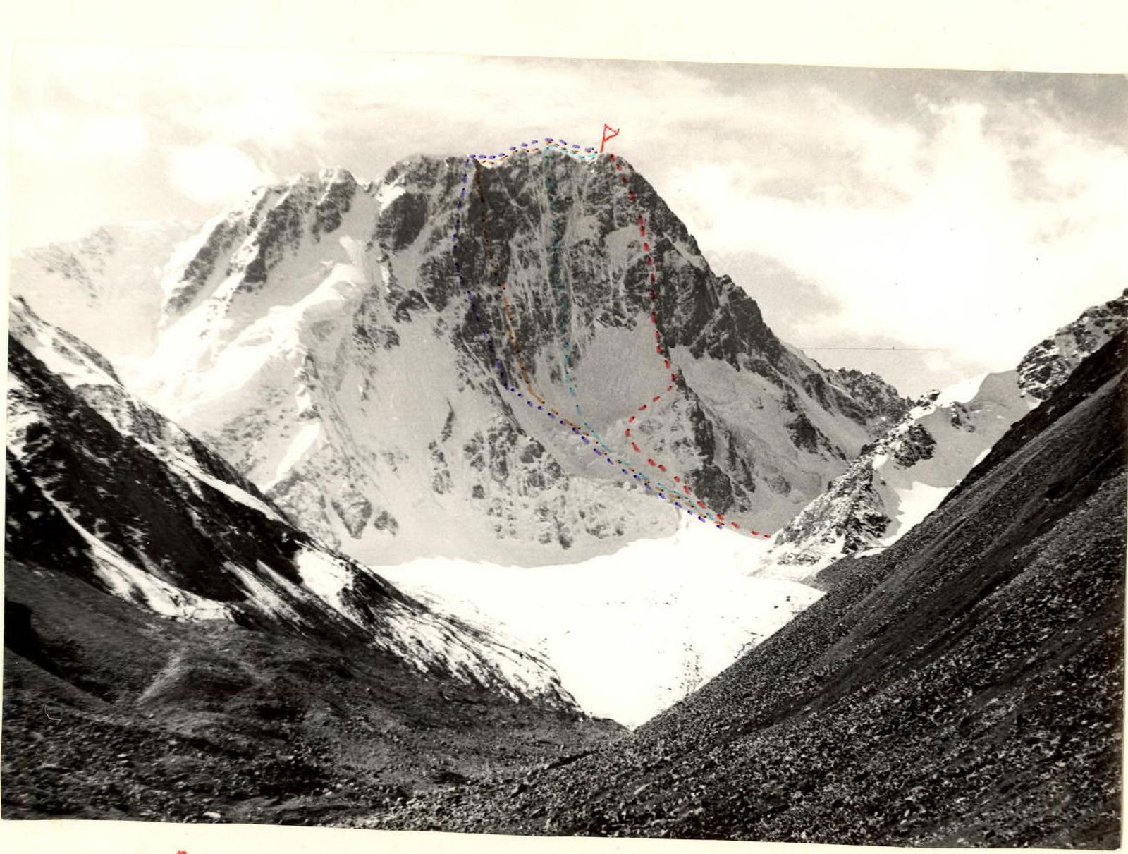
Route Diagrams
- North face — Ryabukhin's route
- Zhurzdin's route
- Slesov's route
- Sharashenidze's route

R21
R18
R16
4950 m, July 29, 1978
R14
R11
4630 m
R6
4400 m, July 26, 27, 1978
R2
R1
3670 m
Table of Main Route Characteristics
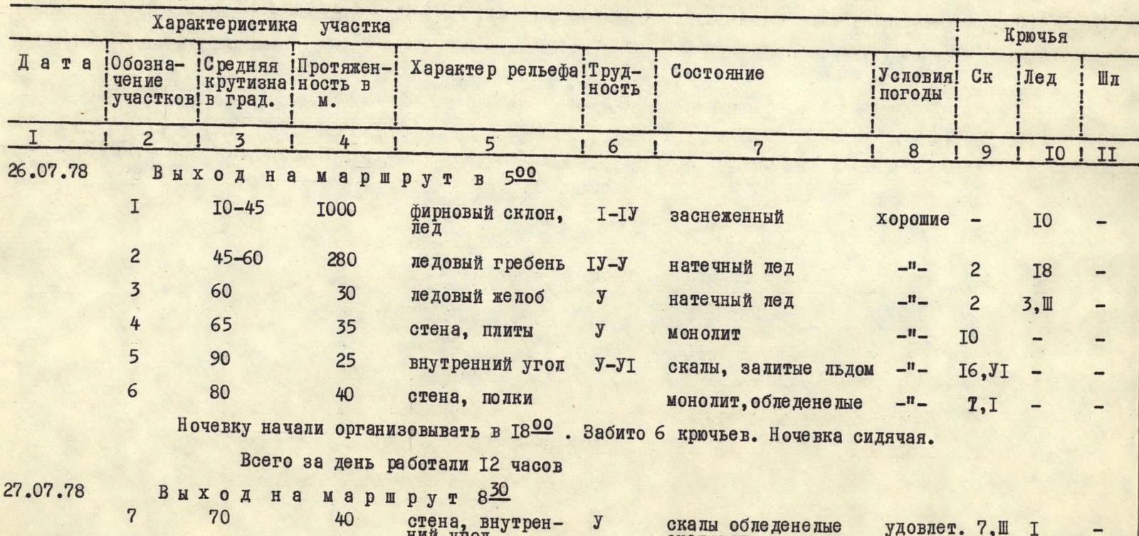
| Date | Designation of sections | Average steepness in degrees | Length in m | Terrain character | Difficulty | Condition | Weather conditions | Rock Pitons | Ice Pitons | Bolt Pitons |
|---|---|---|---|---|---|---|---|---|---|---|
| July 26, 1978 | Departure at 5:00 | |||||||||
| R1 | 10–45 | 100 | firn slope, ice | 1–4 | snow-covered | good | – | 10 | – | |
| R2 | 45–60 | 280 | ice ridge | 4–5 | ice accretion | – | 2 | 18 | – | |
| R3 | 60 | 30 | ice gully | 5 | ice accretion | – | 2 | 3, P | – | |
| R4 | 65 | 35 | wall, slabs | 5 | monolith | – | 10 | – | – | |
| R5 | 90 | 25 | inner corner | 5–6 | rocks covered with ice | – | 16, 5 | – | – | |
| R6 | 80 | 40 | wall, ledges | monolith, icy | – | 7, 1 | – | – | ||
| Started organizing a bivouac at 18:00. 6 pitons driven. Sitting bivouac. | ||||||||||
| Total work time for the day: 12 hours | ||||||||||
| July 27, 1978 | Departure at 8:30 | |||||||||
| R7 | 70 | 40 | wall, inner corner | 5 | icy rocks, snowfall | satisfactory | 1 | – | ||
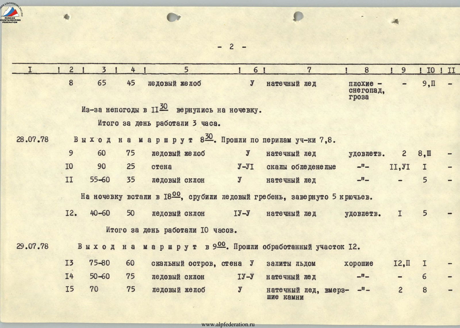
| R8 | 65 | 45 | ice gully | 5 | ice accretion | bad, snowfall, thunderstorm | – | 9, P | – | |
| Returned to bivouac at 11:30 due to bad weather. | ||||||||||
| Total work time for the day: 3 hours | ||||||||||
| July 28, 1978 | Departure at 8:30. Passed R7–R8 via fixed ropes. | |||||||||
| R9 | 60 | 75 | ice gully | 5 | ice accretion | satisfactory | 2 | 8 | – | |
| R10 | 90 | 25 | wall | 5–6 | icy rocks | – | 11, 6 | 1 | – | |
| R11 | 55–60 | 35 | ice slope | 5 | ice accretion | – | – | 5 | – | |
| Established bivouac at 18:00, cut an ice ridge, 5 pitons driven. | ||||||||||
| R12 | 40–60 | 50 | ice slope | 4–5 | ice accretion | satisfactory | 1 | 5 | – | |
| Total work time for the day: 10 hours | ||||||||||
| July 29, 1978 | Departure at 9:00. Passed processed section R12. | |||||||||
| R13 | 75–80 | 60 | rock outcrop, wall | 5 | covered with ice | good | 12, P | 1 | – | |
| R14 | 50–60 | 75 | ice slope | 4–5 | ice accretion | – | – | 6 | – | |
| R15 | 70 | 75 | ice gully | 5 | ice accretion, embedded stones | – | 2 | 8 | – | |
| R16 | 60–70 | 120 | rocky slope | 4–5 | Rocks covered with ice, cut by ice gullies | good | 18 | 5 | – | |
| Established bivouac at 18:00. 3 pitons driven for bivouac organization. | ||||||||||
| Total work time for the day: 8 hours | ||||||||||
| July 30, 1978 | Departure at 9:00 | |||||||||
| R17 | 55 | 35 | ice gully | 4–5 | ice accretion | good | – | 4 | – | |
| R18 | 65 | 40 | couloir | 5 | rocks covered with ice | – | 6 | – | – | |
| R19 | 45–50 | 60 | ice slope | 4 | ice accretion | – | – | 4 | – | |
| R20 | 60 | 50 | rocky slope | 4–5 | rocks covered with ice | – | 9 | 1 | – | |
| R21 | 50–35 | 100 | ice, firn | 4 | snow-covered | – | – | 6 | – | |
| Total work time for the day: ascent — 3.5 hours | ||||||||||
| Descent via the 3rd ridge (4A) — 5 hours |
Brief Explanation of the Table
From the observation camp on the left-bank moraine of the Jigit glacier (3670 m), crossing the glacier and the icefall, we reach the ice ridge (R1). Above the first wall — 1st control point. Between the first and second rises of the ridge — a cornice. Along the ridge (R2) to the overhanging part of the base of the 2nd wall. From here, via the ice gully (R3) to the right and up, then straight up the slabs (R4) to the wall with a characteristic yellow stripe. Next — the inner corner (R5) with a 70–80 cm eave. Then along the wall (R6) via small ledges to the right and up 40 m. Ledge, sitting bivouac.
From the bivouac:
- to the right and up the wall into the inner corner (R7);
- leading into the ice gully with two rock outcrops (R8, R9, R10, R11);
- then crossing it to the left to the top of the 2nd wall under the second ice belt.
At the top of the wall — bivouac and control point.
From the bivouac:
- up the ice slope (R12) to the right part of the rock outcrop (R13);
- after it, along the ice slope (R14) to the base of the ice gully with embedded white stones (R15);
- via it, exit to the snow-ice ridge and along the ridge to the 15-meter wall, which is climbed via the inner corner;
- from the wall, along the snow-ice ridge and then along the rocks up 3 ropes to the start of the wall (R16).
Under the wall — a platform and bivouac.
From the bivouac:
- first, along the ice gully (R17);
- then via a vaguely expressed rocky couloir (R18) to the 4th ice belt;
- along the ice slope (R19) to the last rocky belt;
- along rocks of medium difficulty (R20) to the snow-ice summit dome (R21).
The summit is in the western part on the rocks.
Descent:
- along the western snow-ice ridge to the saddle between the peaks Jigit and Festivalnaya;
- then along the North ice slope;
- further along the corniced ridge to the glacier (6–7 hours).
Protocol
of the ascent review (second passage) to peak Jigit via the North face, 5B cat. diff., made by the group of instructors from a/l "Ala-Too" consisting of Boshman, Usmanov, July 26 — July 30, 1978.
Present:
- Release officer — Slepukhin E.F.
- Head of the rescue team — Sinkovsky A.V.
- Camp instructor — Kapanin V.A.
- Observation group — Borodin S.A., Shnaider K.B.
Boshman: "We departed on the route a day later than planned due to late arrival at the observation camp and lack of communication on the morning of July 25, 1978. In the evening of the 25th, communication was established, and we departed at 5:00.
- The weather on the first day was good, started deteriorating by the end of the day.
- On the second day, we managed to pass only two ropes and had to descend to bivouac due to bad weather — snow, no visibility, thunderstorm.
- On the third day, the weather improved, but we didn't progress much — the uncomfortable bivouac took its toll, and we got very wet.
- On the fourth day, we covered a significant part of the route and finally bivouacked on a good platform.
- At the summit at 12:30 on the fifth day, on the glacier by 18:20, and descended to the base camp the same evening".
Sinkovsky: "Your assessment of the route?"
Usmanov: "The route is very complex, safe, and logical. The rocks are almost entirely icy along the route, and the route has a large height difference (for technical ascents)".
Slepukhin: "Who worked as the lead on the route?"
Boshman: "The lead climbers alternated, but:
- Usmanov worked on the most complex rocky sections.
- I worked on the ice sections".
Sinkovsky: "How was communication?"
Usmanov: "Communication was carried out regularly according to the communication schedule; there were no missed communication sessions".
Kapanin: "Whose notes did you find on the route?"
Boshman:
- "On the first control point, we found a note from Zhurzdin's group, who attempted the route in 1976".
- "No notes were found on the second control point — we left our own".
- "At the summit, we found a note from the Irkutsk gathering group led by Bolousov (via the "sickle" route)".
Slepukhin: "The ascent was performed in accordance with the USSR mountaineering rules and is counted".
Protocol led by: K. Shnaider Release officer: E. Slepukhin July 31, 1978