REPORT
on the ascent to the summit "Brigantina", made by the group of the Novosibirsk Regional Council of the DSO "Zenit" led by V.P. Popov.
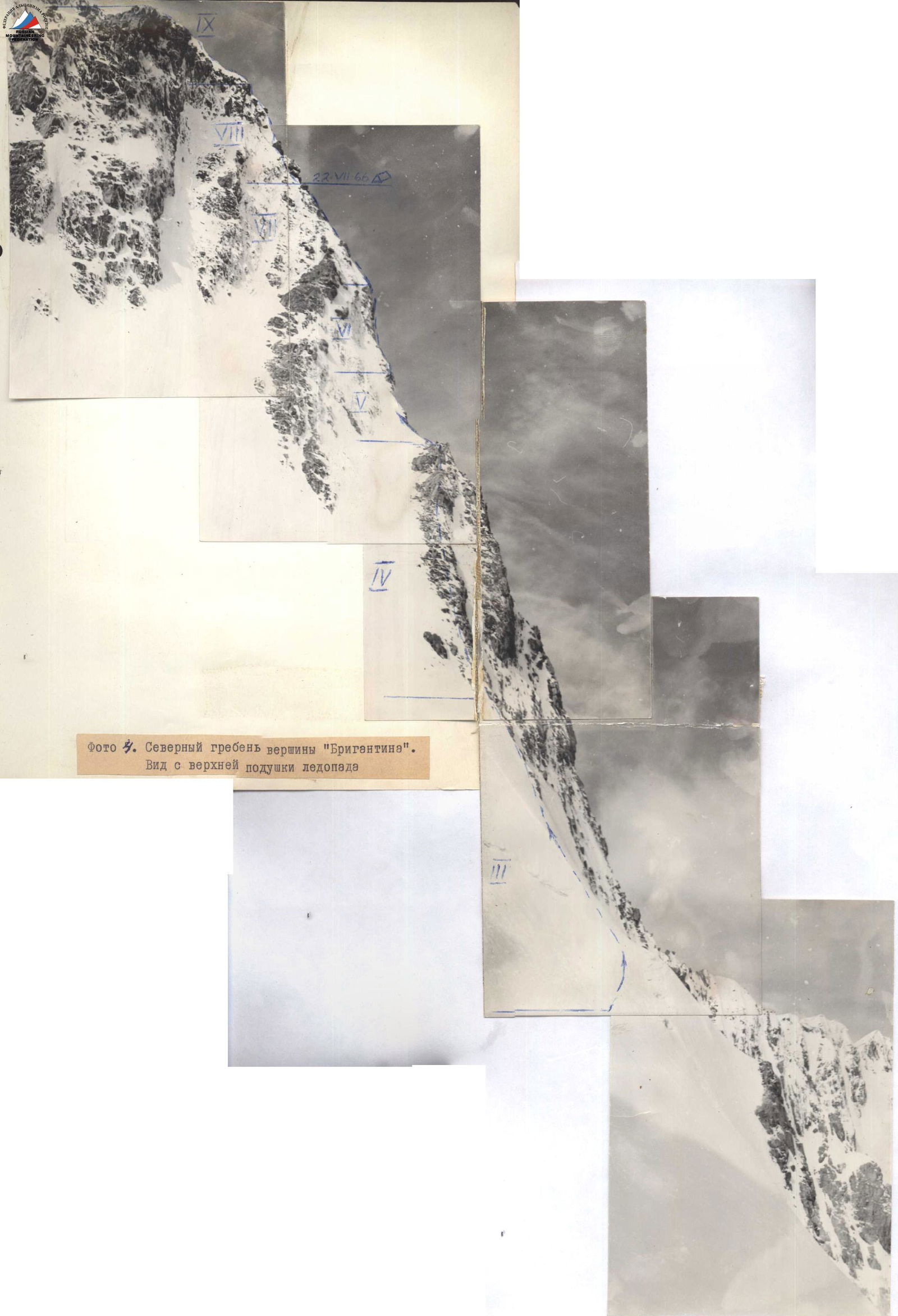
Photo 4. The northern ridge of the summit "Brigantina". View from the upper icefall pad.
1. General description of the area
The summit Brigantina 4800 m is located in the Terskey Ala-Too range, approximately 38 km from Przhevalsk in the northeast direction.
The road goes up to the first saz, from where the distance to the foot of the summit is 8-10 km by horse and foot trail.
The path goes:
- Through the Karakol gorge.
- Further through the Kock-bor gorge - the right bank of the river of the same name, which is a tributary of the Karakol river.
- From the Kock-bor gorge to the left - without a trail through the gorge to the Brigantina glacier.
The weather in this area in August is characterized by instability, with a large number of days with precipitation. Good weather usually lasts from morning until 15:00. On the route, visibility worsens, it snows, which reduces the time of work on the route.
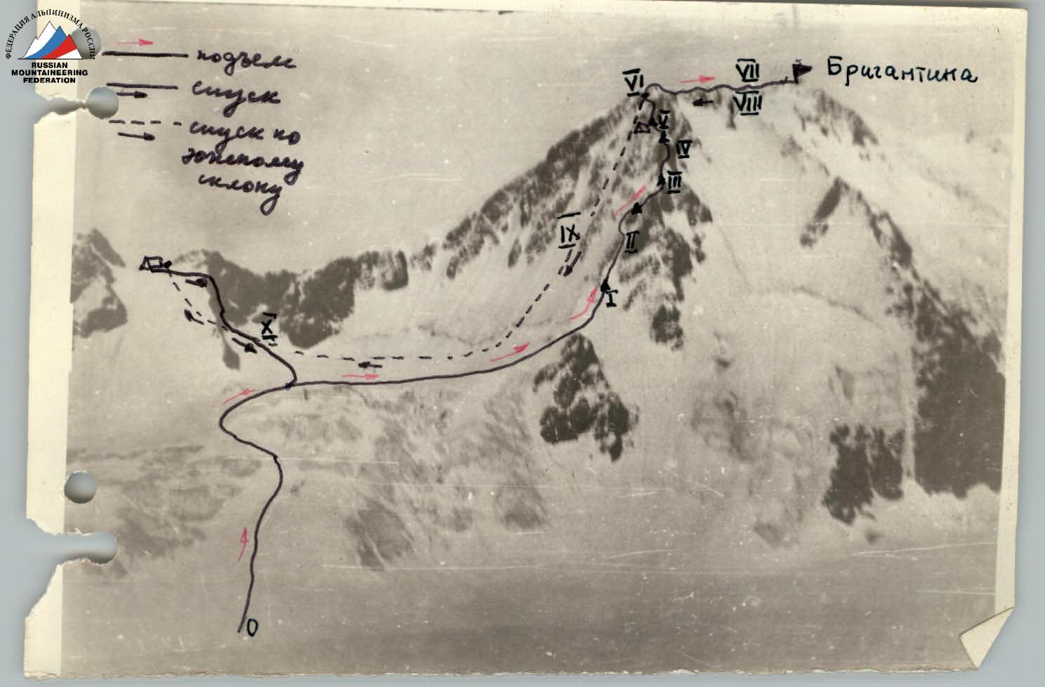
General characteristics of the route. The route to Brigantina along the northern ridge: mixed, snow, ice and rock, rocks are heavily destroyed, many loose stones.
Steps in the snow hold well only at the beginning of the route, where the snow is deep, and after reaching the ridge.
The entire route can be divided into separate sections. R1. Snow - snow and ice from the right icefall pad, a snow slope with a steepness of 20°-90° turns into a snow and ice slope with a steepness of 50°-55°. R2. On the left side of the couloir, rocks of medium complexity, more complex in the upper part, bypassing a large rusty stone along the snow slope on the left, steepness ~50°. R3. Heavily destroyed rocks, climbing of medium complexity, approach to the wall. R4. Rock wall, complex climbing, rocky ridge with a large number of walls 5-10 m (complex climbing). Overnight stay - a place for one tent. R5. At the gendarme - the first one straight - complex climbing, the second one is bypassed on the left, the rest on the right along a steep snow slope near the rocks. Steepness 30°-50°. R6. Snow ridge of medium complexity, two snow and ice drops with a steepness of 35°-40° - exit to the eastern ridge leading to the summit. A place in the hollow for a tent. R7. Destroyed rocky ridge with snow cornices. Before the summit, a snow and ice drop with a steepness of 20° at the bottom to 55°-60° at the top. Descent - by rappel, using a loop. R8. Along the ascent path to the junction of the ridges. R9. Descent along a rocky and icy couloir down to the glacier and ascent to the saddle between the peaks and Brigantina. Overnight stay in a hollow between two gendarmes. R10. Descent along the left edge of the rocks to the upper icefall pad and along one's own tracks to the Brigantina glacier.
Tactical plan of ascent, equipment
Guided by the description of the route and taking into account the weather conditions, it was decided to start the route with an overnight stay under the Brigantina glacier at 16:00. Stop for the first overnight stay after passing the walls in front of the first gendarme. Number of working hours is about 10.
On the second day - exit to the ridge, ascent to the summit and descent from the summit to the saddle on the col between MGMI and Brigantina.
On the third day - descent to the Brigantina glacier from the col and return to the camp under the glacier by one's own tracks.
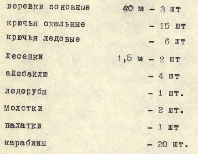
It was decided to take with them - for 5 people:
- main ropes - 40 m - 3 pcs.
- rock pitons - 15 pcs.
- ice pitons - 6 pcs.
- ladders - 1.5 m - 2 pcs.
- ice axes - 4 pcs.
- axe hammers - 1 pc.
- hammers - 2 pcs.
- tents - 1 pc.
- carabiners - 20 pcs.
It was decided to maintain communication with the group under "Dzhigit" by flares.
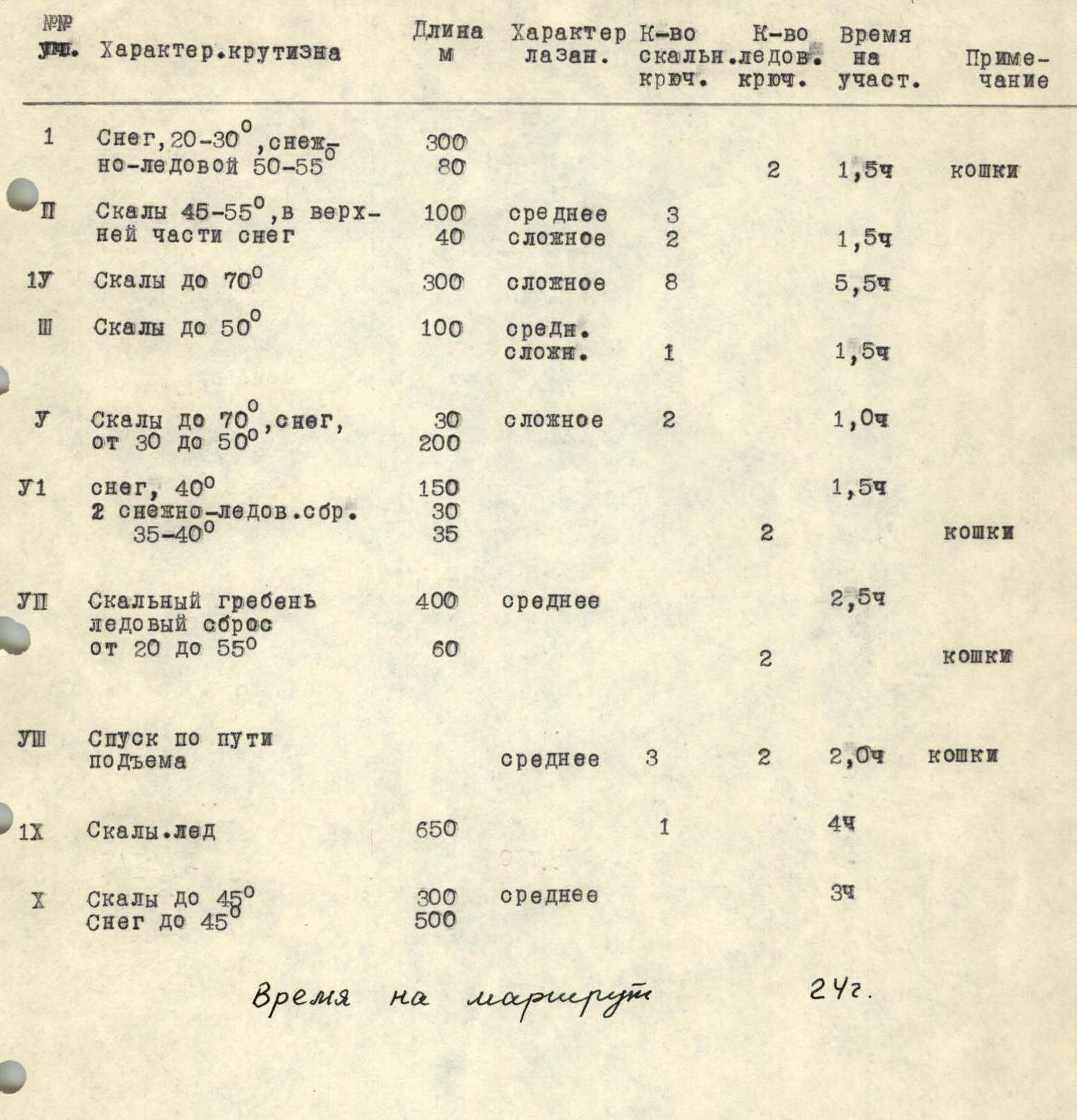
Distribution of the route by sections
| № | Section | Character, steepness | Length, m | Character of climbing | Number of rock pitons | Number of ice pitons | Time on the section, h | Note |
|---|---|---|---|---|---|---|---|---|
| R1 | Snow, 20°–30°, snow and ice 50°–55° | 300, 80 | 2 | 1.5 h | crampons | |||
| R2 | Rocks 45°–55°, snow in the upper part | 100, 40 | medium, complex | 3, 2 | 1.5 h | |||
| R3 | Rocks up to 50° | 100 | medium complexity | 1 | 1.5 h | |||
| R4 | Rocks up to 70° | 300 | complex | 8 | 5.5 h | |||
| R5 | Rocks up to 70°, snow, from 30° to 50° | 30, 200 | complex | 2 | 1.0 h | |||
| R6 | Snow, 40°, 2 snow and ice drops 35°–40° | 150, 30, 35 | 2 | 1.5 h | crampons | |||
| R7 | Rocky ridge, ice drop from 20° to 55° | 400, 60 | medium | 2 | 2.5 h | crampons | ||
| R8 | Descent along the ascent path | medium | 3 | 2 | 2.0 h | crampons | ||
| R9 | Rocks, ice | 650 | 1 | 4.0 h | ||||
| R10 | Rocks up to 45°, snow up to 45° | 300, 500 | medium | 3.0 h |
Time on the route: 24 h.