FIRST ASCENT PASS
- Class — technically challenging ascents.
- Region:
- Tian-Shan,
- Terskey Ala-Too ridge,
- Kara-Kol gorge,
- Brigantina glacier area.
- Route name — Brigantina peak via the North-West ridge.
- Proposed difficulty category — 4A.
- Height difference — 710 m, route length 980 m, average steepness 45–50°. Length of sections with 5th difficulty category — 40 m, 4th difficulty category — 580 m.
- On the route: ice screws screwed in — 12, rock anchors hammered in — 3, chocks placed — 6, cordelettes hung — 8.
- The route took 6 h 30 min from the bastion to the summit and 10 h 30 min from bivouac to bivouac.
- There were no bivouacs on the route.
- Team composition:
- KARELIN Aleksandr Olegovich — leader, 2nd sports category
- ANDREEVA Lyudmila Ivanovna — member, 2nd sports category
- VLASOV Mikhail Andreevich — member, 2nd sports category
- DEMIDENKO Oleg Georgievich — member, 2nd sports category
- NEKLYUDOV Andrey Fedorovich — member, 2nd sports category
- Team coach KOLCHIN Aleksandr Aleksandrovich, Master of Sports of International Class
The ascent was made on August 21, 1983.

Photo 1. North-west ridge of Brigantina peak (4800 m). Taken from the lateral moraine of Brigantina glacier on August 20, 1983. "Smena" camera.
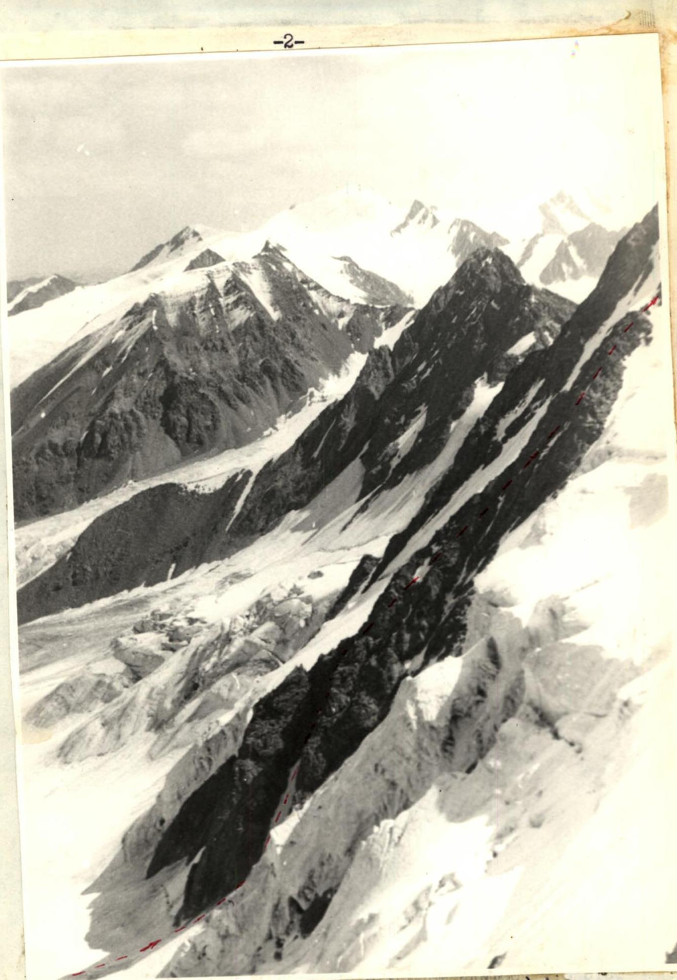
Photo 2. Route profile on the right (lower part). Taken from Solntse pass on August 19, 1983. "Smena" camera.
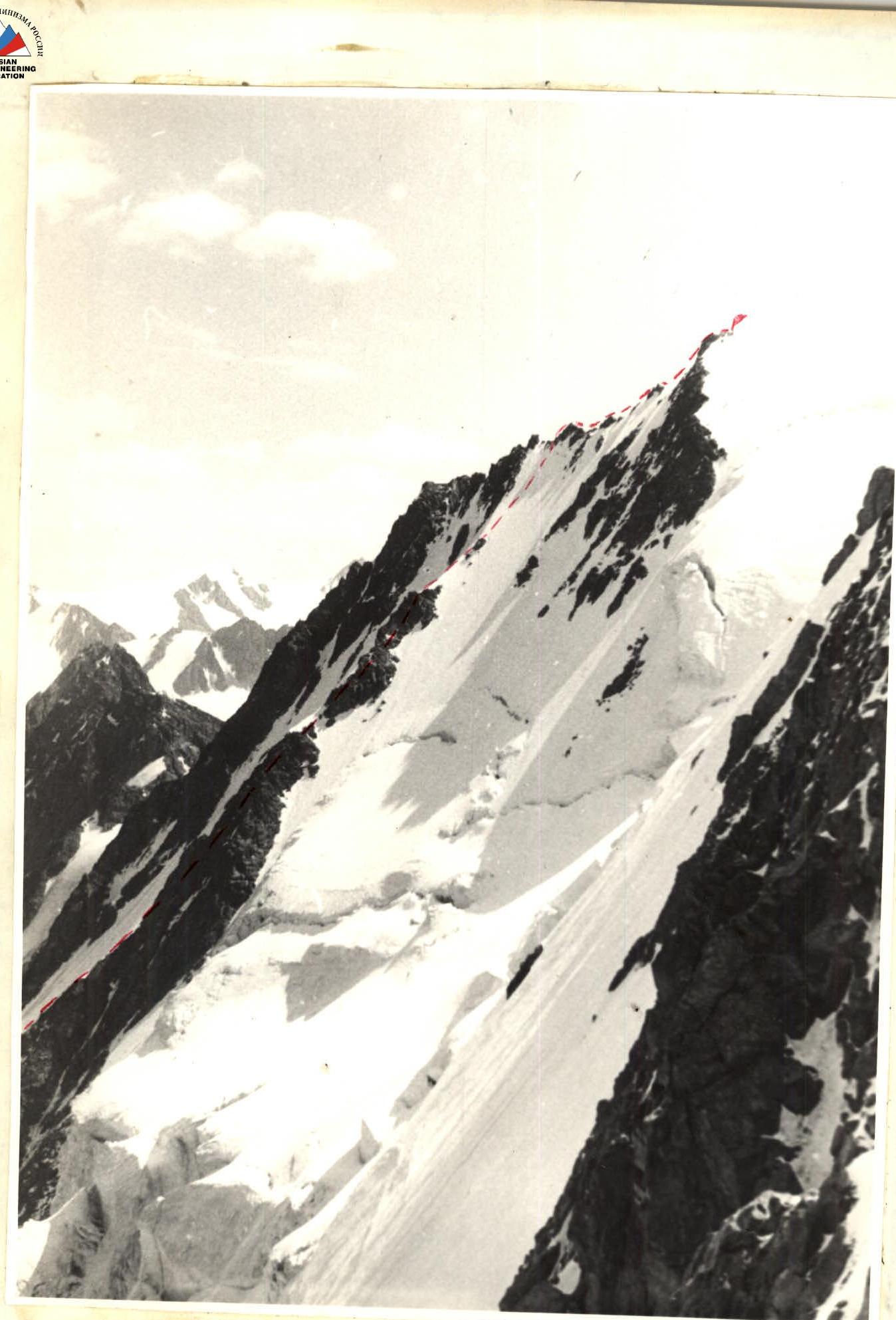
Photo 3. Route profile on the right (upper part). Taken from Solntse pass on August 19, 1983. "Smena" camera.
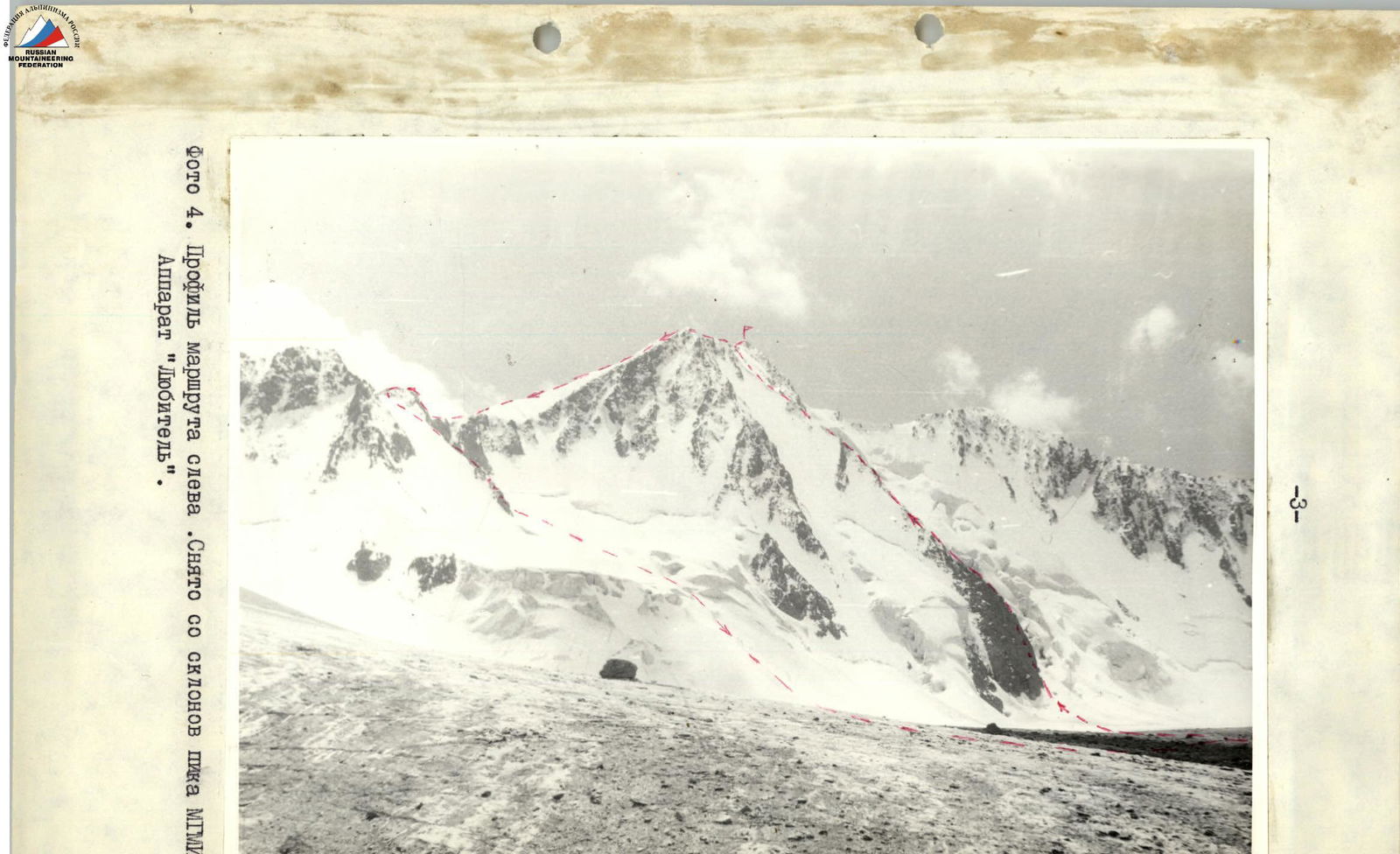
Photo 4. Route profile on the left. Taken from MGMI peak slope. "Lyubitel" camera.
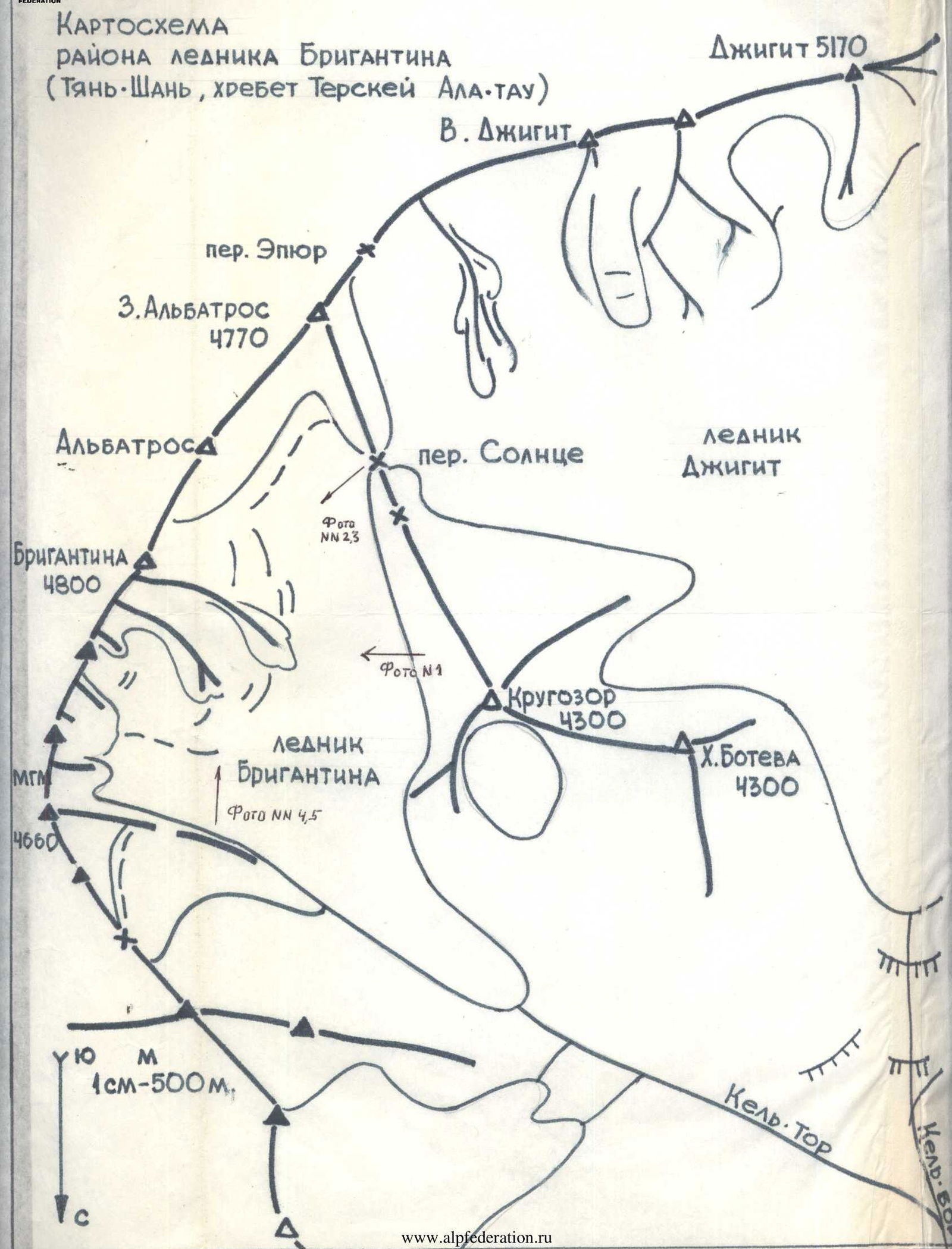
Map of Brigantina glacier area (Tian-Shan, Terskey Ala-Too ridge)
| Route diagram in UIAA symbols | Section # | Time actual | Climbing hours | Difficulty category | Length in m. | Steepness | Terrain characteristics | Equipment |
|---|---|---|---|---|---|---|---|---|
| 7 | 11:00 | 0:30 | 4 | 200 | Summit ridge, sharp | 2 chocks, belay on ledges and via cordelettes. 4 ice screws | ||
| 6 | 11:30 | 0:45 | 5 | 40 | 50–55° | Steep ice | 6 ice screws | |
| 5 | 9:45 | 0:30 | 3 | 80 | 40° | Ice and snow slope | ||
| 4 | 9:15 | 0:30 | 3 | 80 | 35° | Snow ridge | ||
| 3 | 8:45 | 1:15 | 4 | 40 | 60° | Wall ascent. Rock wall | 2 rock anchors | |
| 3 | 300 | 45° | Rock ridge | Belay on ledges and via cordelettes | ||||
| 2 | 7:30 | 0:30 | ||||||
| 1 | 7:00 | 1:00 | 4 | 60 | 60° | Rock couloir (rocks are destroyed) | Belay on ledges and via cordelettes | |
| 0 | 6:00 | 0 | 4 | 160 | 45° | Snow and ice couloir | 2 ice screws, 3 chocks, 1 rock anchor |
Description of the route to Brigantina peak (4800 m) via the North-West ridge, approximately 4A category.
From the initial bivouac on the talus site near Brigantina glacier, we cross the gentle part of the glacier and approach the steep rock counterfort. The beginning of the route goes through a snow and ice couloir, bypassing the counterfort on the right (section R0–R1, 160 m, 4th category).
To the right of the couloir is an icefall, to the left under the counterfort — traces of falling rocks, so you should move along the left part of the couloir along the rocks.
The snow and ice couloir turns into a rock couloir with heavily destroyed rocks (section R1–R2, 80 m, 4th category). Movement is on a shortened rope, close to each other. The couloir leads to the North-West ridge. On the site at the exit from the couloir to the ridge — the first control point.
Further movement goes along the rocky North-West ridge along the top and to the right, as there are steep rocks on the left (section R2–R3, 300 m, 3rd category).
In the upper part of the rock ridge we overcome a wall ascent (section R3–R4, 40 m, 4th category). The ascent leads to a site, from which a snow ridge with cornices begins (section R4–R5, 80 m, 3rd category).
Along the snow ridge we move to a characteristic rock outcrop, from where we start moving along the snow and ice slope (section R5–R6, 80 m, 4th category).
Further movement along the snow ridge leads to the left of the summit, besides, the ridge further ends with destroyed and rockfall-prone rocks. In the upper part, the snow and ice slope turns into a steep ice slope (section R6–R7, 40 m, 5th category). Along it we exit to the North-East summit ridge. This section of the ridge is sharp, combined, consists of small rock and ice gendarmes, with snow bridges and cornices and is one of the key sections of the traverse of the 4B category massif (section R7–R8, 200 m, 4th category). Along the North-East ridge we reach the summit.
Descent is via the ascent route and further along the North-East ridge to Brigantina pass. From the pass we move down the rocks, and then to the right into a snow corrie, from where we descend via an icefall to Brigantina glacier, and from Brigantina glacier — to the initial bivouac.


