Ascent of Pik Blyukhera via the Northeast Face
I. CLIMBING CLASSIFICATION: Technical 2. CLIMBING REGION: Tian Shan, Terskey Ala-Too 3. SUMMIT: Pik Blyukhera (4720 m) via NE face 4. CLAIMED DIFFICULTY CATEGORY: 5A 4A 5. ROUTE CHARACTERISTICS: elevation gain — 600 m average steepness — 70° section lengths: 1st cat. diff. — 30 m, 2nd — 170 m, 3rd — 160 m, 4th — 250 m, 5th — 120 m, 6th — 10 m. 6. PITS SET: for protection: for creating artificial anchors ROCK: 45 ICE: 3 7. TOTAL CLIMBING TIME: 20 hours 8. NUMBER OF NIGHTS SPENT AND THEIR CHARACTERISTICS: 1 night. Platform made of stones on an inclined ledge on the second snow belt. 9. FULL NAME OF THE LEADER, PARTICIPANTS, AND THEIR SPORTS QUALIFICATION: Boyko Vasily Grigorievich — 1st sports category Beda Vasily Onifatovich — 1st sports category Golovaty Alexander Borisovich — 1st sports category Sereda Vladimir Petrovich — 1st sports category Gordeev Vladimir Polikarpovich — Candidate Master of Sports 10. TEAM COACH: 11. DATE OF DEPARTURE AND RETURN: July 30, 1977 — August 2, 1977
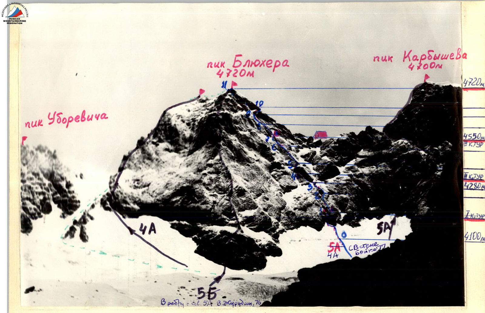
Northeast face of Pik Blyukhera View from the eastern ridge of Pik Karbysheva
ROUTE DESCRIPTION First ascent of Pik Blyukhera (4720 m) via the northeast face.
From the base camp to the left (orographic) moraine of the Karbyshev Glacier. Overnight under the eastern ridge of Pik Karbysheva. 6 hours from the base camp.
From the overnight location, crossing the glacier, to the northeast face of Pik Blyukhera. Along the snow-ice slope under the hanging red rocks on the right part of the NE face, crossing the bergschrund along the edge of the avalanche chute.
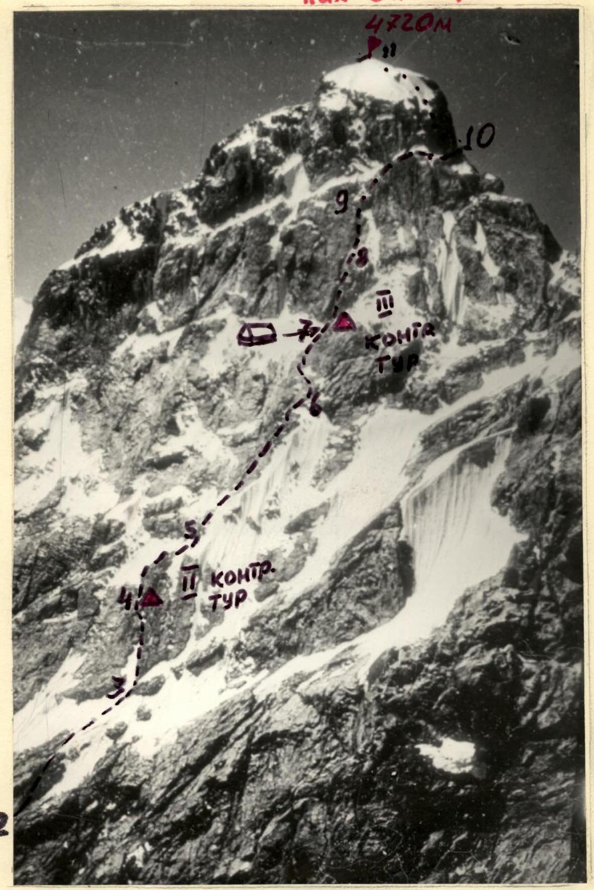
Section R0–R1. After the bergschrund, a 55–60° snow-ice slope — 40 m. Bypassing the "Red" rock on the left, exit to the rocks. Along the right wall of the couloir, a 3 m — 80° steep wall. Using a ladder, exit through steep, crumbling rocks into a wide chimney. Along the right wall of the chimney, using a ladder, exit onto stepped ledges. Along the ledges to the right, exit onto a narrow, inclined ledge. 1 control cairn on the ledge. 5 pitons driven. Difficult climbing in places. Piton protection and upper section protection through ledges.
Section R1–R2. From the end of the ledge straight up the 70° wall, along rocks of medium difficulty, veering right in the upper part, exit under an overhanging rock. 75 m from the 1st control cairn. Piton protection. 10 pitons driven.
Section R2–R3. Exit in the right part of the overhanging rock is relatively easy. First, along an external corner 80° — 10 m, exit to rocks of medium difficulty — 10 m, then along stepped slabs covered with snow, exit to the first snow belt. Crossing the snow-ice slope — 15 m, exit under a rock resembling an iron. Overnight possible. Piton protection, 5 pitons driven.
Section R3–R4. Along the "Iron", bypassing it on the left into the inner corner and through it, exit onto an inclined, wide ledge. 30 m from the base of the "Iron". Piton protection. 4 pitons driven.
Section R4–R5. From the ledge, along the 80° wall — 20 m, veering left through a crack, exit to the top of the "Iron" and along simple, crumbling rocks (STONE FALL HAZARD!), exit to "tile-like" rocks. 35 m from the ledge. Piton protection and protection through ledges. 3 pitons driven.
Section R5–R6. Along "tile-like" blocks 60 m under a vertical
Sections R8 and R9. View from the overnight platform.
wall. Easy climbing. Protection through ledges. STONE FALL HAZARD!
Section R6–R7. Along the monolithic wall straight up 15 m, then traverse left-up 10 m. Difficult climbing. Small holds, washed by running water. Further along the external corner, exit to the top of the wall 15 m. Overnight platform. III control cairn. Piton protection and protection through ledges, 4 pitons driven. 13–15 hours from the glacier overnight.
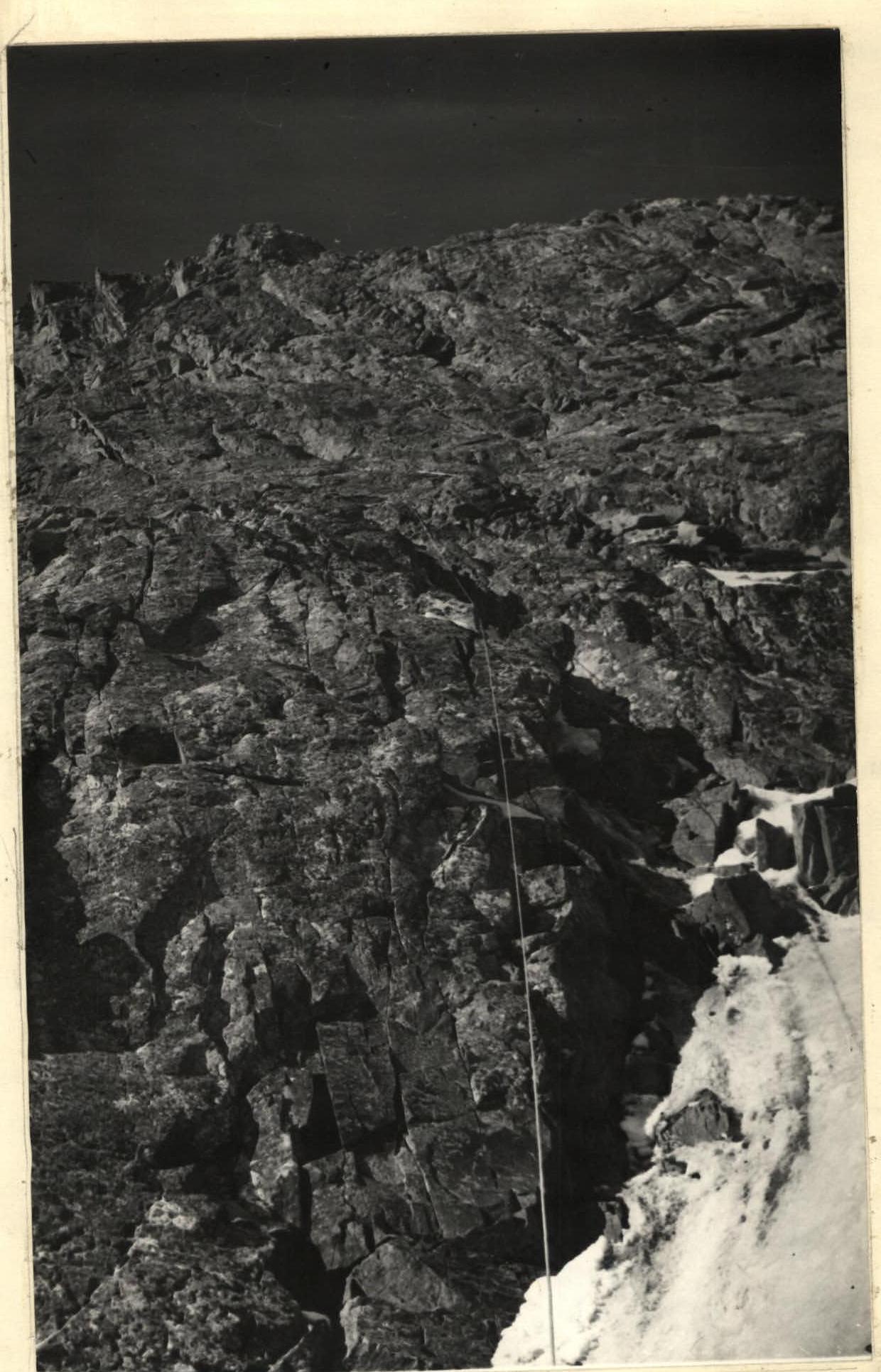
Section R7–R8. From the platform straight up, crossing the snow-ice slope, along the wall 20 m (see photo #5), exit to snow-covered, crumbling rocks — 20 m. STONE FALL HAZARD! Piton protection and protection through ledges.
- 3 pitons
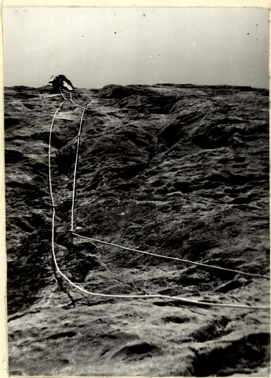
Section R8–R9. Along the monolithic wall 25 m under an overhanging rock with a crack in the left part. Along the crack 10 m, using a ladder, onto the overhanging rock, then transfer to the right part and further up — exit to ledges under the third snow belt. Difficult climbing. 8 pitons driven. See photo #6.
Section R9–R10. Along the ledges to the right — exit to the snow belt (overnight possible). Along the snow belt, traverse to the right — exit to the ridge 30 m. Bypassing the ridge on the right along a ledge 20 m — exit under a large couloir exiting directly to the summit. Easy climbing. Protection through ledges.
Section R10–R11. Along the right wall of the couloir 10 m — exit into a wide chimney 10 m, which again exits into the couloir. Along the couloir 60 m to the summit of Pik Blyukhera. Climbing of medium difficulty. Piton protection and protection through ledges. 6 pitons driven. 7–8 hours from the wall overnight.
From the summit along the ridge to Pik Tukhachevsky 90 m. Then, bypassing the southern ridge on the left, along a ledge 120 m and descend 80 m via rappel. Along debris-covered ledges to the glacier and along it to the overnight location. Descent takes 2–3 hours.
The ascent was made from July 31 to August 2, 1977. Ascent leader V. Boyko

Section #9 — Key Location of the Route
Profile of the Northeast Face of Pik Blyukhera View from Pik Karbysheva.
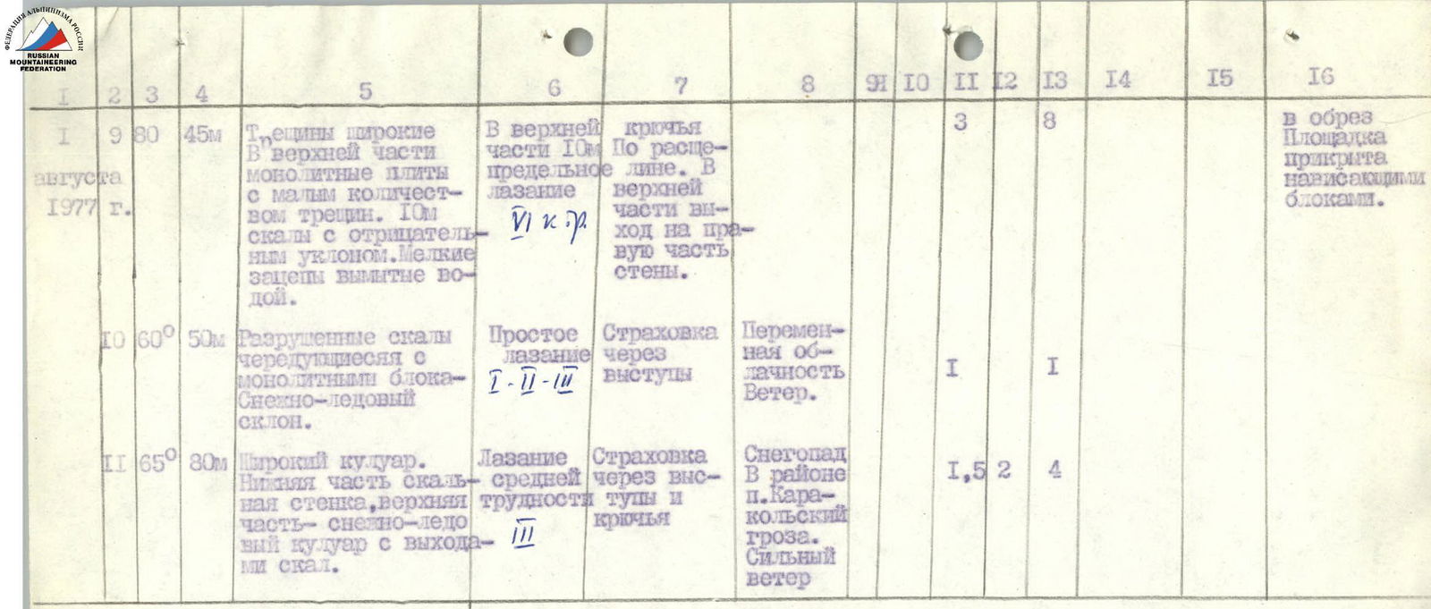
Table
Main Characteristics of the First Ascent Route on Pik Blyukhera via the Northeast Face
| Date | Sections Covered | Average Steepness of Section | Section Length, Slope | Characteristics of Sections and Climbing Conditions (by terrain character) | Technical Difficulty | Climbing Method and Protection | Weather Conditions | Time of Departure to Bivouac | Time of Return | Climbing Hours | Pitons Driven (Rock) | Pitons Driven (Ice) | Pitons Driven (Bolt) | Weather Conditions | Food Ration |
|---|---|---|---|---|---|---|---|---|---|---|---|---|---|---|---|
| 1 | 2 | 3 | 4 | 5 | 6 | 7 | 8 | 9 | 10 | 11 | 12 | 13 | 14 | 15 | 16 |
| 30.07.1977 | From base camp to Karbyshev Glacier | Clear | 11:00 | 18:00 | 6 | 2.5 kg | |||||||||
| 31.07.1977 | 1 | 90° | 35 m | Snow-ice slope, bergschrund | Steps in snow. Protection through ice axe. | Variable cloudiness | 1 | ||||||||
| 70° | 40 m | Granite, monolithic rocks in the middle part, broken blocks. Small holds. Smooth slabs in places. | Difficult climbing 4–5 cat. diff. | Free climbing. On slabs using ladders. Piton protection. | 1.5 | 5 | 1.5 kg | ||||||||
| 2 | 70° | 30 m | Granite. Monolithic rocks. Cracks for bolt pitons. | Climbing of medium difficulty 3–4 cat. diff. | Free climbing. Piton protection. | Fog | 2 | 10 | |||||||
| 3 | 65° | 45 m | Monolithic rock in the lower part, slabs like "ram's foreheads", rime ice. Snow-ice slope. | Difficult climbing in the lower part 4–5 cat. diff. | Protection | Snowfall, fog | 1.5 | 5 | |||||||
| 31.07.1977 | 4 | 75° | 35 m | Monolithic rock, steep ice slope. | Climbing of medium difficulty 3–4 cat. diff. | Piton protection | Snowfall, fog | 1 | 1 | 3 | |||||
| 5 | 70° | 35 m | Monolithic rock in the lower part with vertical cracks. Above, slabs like "ram's foreheads". Loose stones on ledges. | Difficult climbing in the lower part 4–5 cat. diff. | Piton protection and protection through ledges. | Variable cloudiness | 1 | 2 | |||||||
| 6 | 70° | 90 m | Severely dissected rocks, cracks filled with ice. | Easy climbing 2–3 cat. diff. | Protection through ledges | Clear, temperature 10° | 1 | ||||||||
| 7 | 80° | 35 m | Monolithic rock with few cracks. Water on rocks in the upper part, small holds. | Difficult climbing 4–5 cat. diff. | Along the left part of the wall. Piton protection and protection through ledges. | Variable cloudiness | 2 | 4 | |||||||
| 01.08.1977 | 8 | 70° | 35 m | Ice slope, ice chute, crumbling, snow-covered rocks. Cracks filled with ice. | Difficult climbing 4–5 cat. diff. | Steps on ice. Protection through ledges and pitons. | Clear | 20:00 | 7:30 | 1.5 | 3 | Platform made of stones on an inclined rock ledge. Snow-ice slope nearby. Tent fits on the platform. | |||
| 9 | 80° | 45 m | Broken blocks in the lower part. Monolithic slabs in the upper part with few cracks. 10 m rock with negative slope. Wet holds, washed by water. | 10 m in the upper part — extreme climbing 5 cat. diff. | Pitons. Along the crack. In the upper part, exit to the right part of the wall. | Clear | 3 | 8 | |||||||
| 10 | 60° | 50 m | Crumbling rocks alternating with monolithic blocks. Snow-ice slope. | Easy climbing 2–3 cat. diff. | Protection through ledges | Variable cloudiness. Wind. | 1 | 1 | |||||||
| 11 | 65° | 80 m | Wide couloir. Lower part — rock wall, upper part — snow-ice couloir with rock outcrops. | Climbing of medium difficulty 3 cat. diff. | Protection through ledges and pitons. | Snowfall in the Karakolsky Peak area. Thunderstorm. Strong wind. | 1.5 | 2 | 4 | Barely enough. Platform is sheltered by overhanging blocks. |
Team leader of the Dnepropetrovsk gatherings V. Boyko