Ascent Passport
-
Ascent class — technical
-
Ascent area: Terskey Ala-Too ridge
-
Peak, its height, ascent route: p. Albatros Zap. (4700), via the spur on the N wall
-
Estimated difficulty category: 4B
-
Route characteristics:
height difference — 600 m, length of sections with 5th cat. diff. — 180 m, average steepness — 60°, number of rock pitons hammered — 35, number of placements — 14, number of ice screws — 18
-
Number of travel hours: 15
-
One overnight stay — on the moraine of Djigit glacier
-
Team composition:
- Sveshnikov Boris Vladimirovich — CMS
- Lapshin Dmitriy Viktorovich — CMS
- Spiridonov Igor Olegovich — 2nd sports category
- Rogov Anatoliy Veniaminovich — 2nd sports category
-
Team coach: Kuvator Gennadiy Dmitrievich — CMS, 2nd category instructor
-
Date of departure on the route: August 2, 1984 Date of return from the route: August 2, 1984
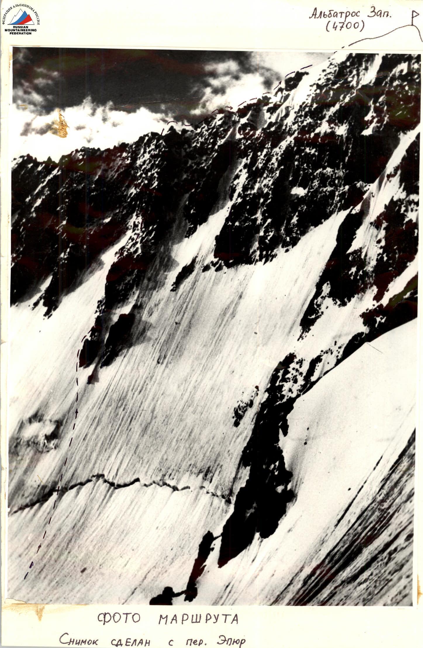
Photo taken from p. Epyur
Table of main characteristics of the ascent route
| Designations | Average steepness (degrees) | Length (m) | Terrain characteristics | Difficulty cat. | Condition | Rock pitons | Placement pitons | Ice screws |
|---|---|---|---|---|---|---|---|---|
| R0–R1 | 50 | 180 | ice wall | 4 | ice | 16 | ||
| R1–R2 | 80 | 20 | rock wall | 4 | rocks with snow | 2 | ||
| R2–R3 | 60 | 25 | — | 4 | — | 1 | 1 | |
| R3–R4 | 70 | 15 | — | 5 | rocks with ice accretion | 1 | 2 | |
| R4–R5 | 70 | 8 | internal corner | 5 | — | 2 | 1 | |
| R5–R6 | 80 | 10 | rock wall | 5 | dry rocks | 2 | 1 | |
| R6–R7 | 60 | 25 | — | 4 | snow-covered rocks | ledges | ||
| R7–R8 | 30 | 40 | rocks | 2 | — | 1 | 1 | |
| R8–R9 | 60 | 15 | rock wall | 4 | rocks with ice accretion | ledges | ||
| R9–R10 | 80 | 5 | — | 5 | — | 3 | ||
| R10–R11 | 65 | 15 | — | 5 | — | 2 | 1 | |
| R11–R12 | 75 | 30 | internal corner | 5 | — | 4 | 1 | |
| R12–R13 | 70 | 15 | rock wall | 5 | dry rocks | 3 | ||
| R13–R14 | 90 | 8 | — | 5 | — | 1 | 1 | |
| R14–R15 | 80 | 30 | — | 5 | — | 5 | 1 | |
| R15–R16 | 30 | 20 | rocks | 2 | snow-covered rocks | ledges | ||
| R16–R17 | 65 | 40 | rock wall | 5 | rocks with ice accretion | 5 | 2 | 1 |
| R17–R18 | 50 | 40 | — | 4 | — | 4 | 2 | |
| R18–R19 | 35 | 20 | snow ascent | 3 | snow | |||
| R19–R20 | 50 | 50 | rocks | 3 | snow-covered rocks | ledges | ||
| R20–R21 | 40 | 10 | ice wall | 3 | ice | |||
| R21–R22 | 10 | 200 | rocks on the ridge | 3 | snow-covered rocks | ledges |

Descent to p. Epyur and further along the glacier to the moraine on Djigit glacier
Route description
The route goes first along the ice wall, then along a clearly defined spur in the center of the North wall of p. Albatros.
- R0–R1: Along the ice wall, bypassing the first rocky island on the left, then exiting onto the spur.
- R1–R2: Rocky wall.
- R2–R3: To the left of the outer corner along the rocky wall.
- R3–R4: Along the wall with a crevice — exit onto a ledge.
- R4–R5: Bypassing the wall with an overhang on the right along the internal corner.
- R5–R6: Exit onto a ledge and bypassing the overhang on the right along the wall.
- R6–R7: Exit onto a ledge, further along the wall and internal corner.
- R7–R8: Rocky ridge.
- R8–R9: Wall with ice accretion.
- R9–R10: Along the wall with ice accretion — exit onto a ledge.
- R10–R11: Wall with ice accretion.
- R11–R12: Bypassing the red wall on the right and further up the wall — exit onto a ledge.
- R12–R13: Along the internal corner — exit onto a ledge.
- R13–R14: Wall with an overhang.
- R14–R15: Wall with dry rocks.
- R15–R16: Simple rocks.
- R16–R17: Along the wall with ice accretion — exit onto a ledge.
- R17–R18: Wall with ice accretion.
- R18–R19: Snow ascent.
- R19–R20: Snow-covered rocks.
- R20–R21: Snow-ice ascent, exit onto the ridge.
- R21–R22: Along the ridge to the summit.