Ascent Certificate (First Ascent) I. Category - technically difficult ascents.
- Region - Tian Shan, Terskey Ala-Too, Karakol Valley, Brigantina Glacier area.
- Route Name: To the peak Zapadny Albattros via the North face.
- Proposed difficulty category - 5B cat. diff. 46 pitches. 528, p.1. From the bergschrund to the summit.
- Elevation gain 400 m. Length - 700 m. Length of 5 cat. diff. section - 370 m.
- On the route: ice screws - 24
rock pitons - 8
placed chocks - 6
used slings - 11
- The route took 12 hours of climbing (from the bergschrund to the summit, including 3 hours of preparation)
16.5 hours of climbing from bivouac to bivouac.
- Team members: Kolchin Alexander Alexandrovich, Master of Sports of International Class
Osipov Yuri Afanasievich, 1st sports category
- Coach: Kolchin Alexander Alexandrovich.
- The ascent was made on August 13, 1983.
(1–83)
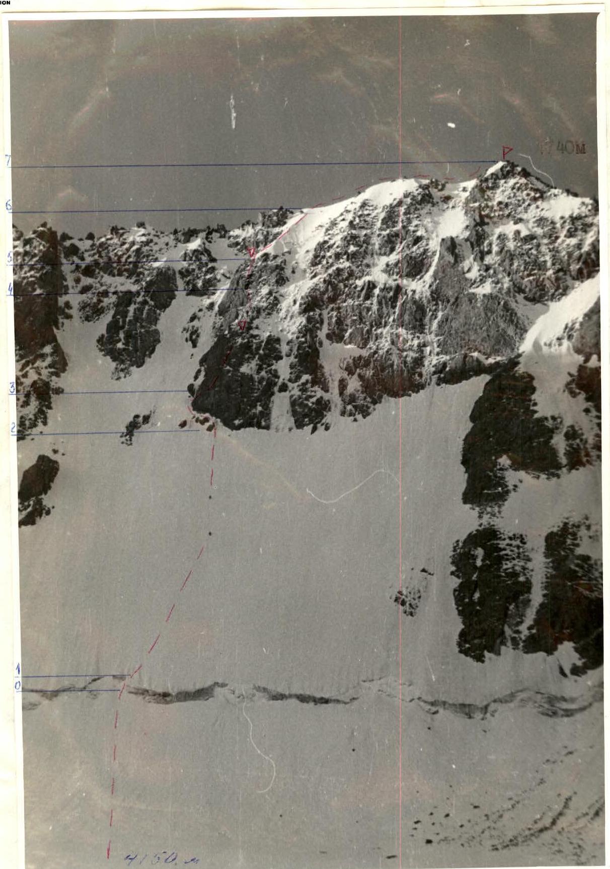
Photo 1. North face of peak Zapadny Albattros (4740 m). Taken from the upper reaches of the Brigantina Glacier on August 13, 1983. A working rope pair is visible on the route. Camera "Smena".
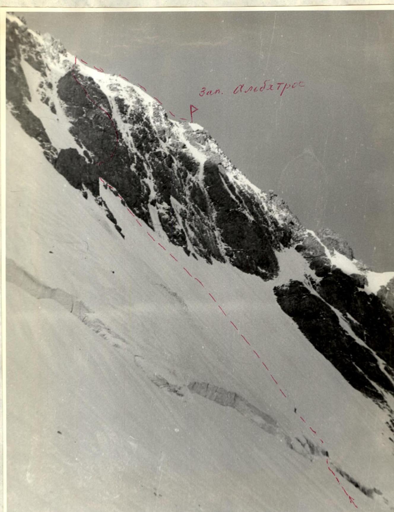
Photo 2. Profile of the route from the left from the upper cirque of the Brigantina Glacier. Taken on August 13, 1983. Camera "Smena".
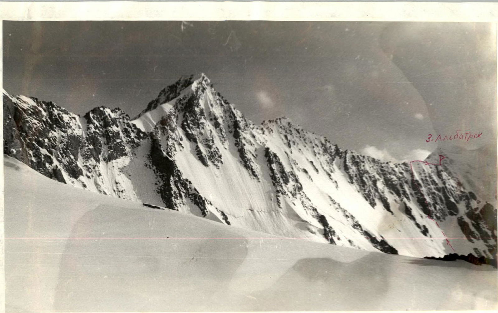
Photo 3. Profile of the route from the left, from the MGMI Glacier. Taken in July 1982. Camera "Smena".
Photo 4. Panorama of the Brigantina—Albattros massif. Previously climbed routes and camera positions are marked:
- photo 1
- photo 2
Photo 10. Alpine pass. Lens Voigtländer Helomar 1:3.5 f=10.5 6x9.

Description of the Brigantina—Albattros Massif
Central Tian Shan, Terskey Ala-Too ridge. The peaks Brigantina—Albattros form a single massif, very beautiful and representing great climbing interest with combined routes of 4B–5B cat. diff. The massif is located on the main crest of the Terskey Ala-Too ridge. The crest of the massif stretches from SW from the Epur Pass (which separates it from the Dzhigit massif) to NE to the Brigantina Pass (which separates it from the MGMI massif).
The massif includes the peaks: Brigantina (4800 m), East (main) Albattros, West Albattros (4740 m).
From peak Zapadny Albattros, a spur extends to the NW with relatively low peaks, which are of little climbing interest:
- Krogzor
- p. Kh. Boteva (1B cat. diff. by any route)
They are excellent panoramic points. These peaks are separated from the main massif by the Solntse Pass.
The following routes have been laid on the massif:
- Traverse of the massif with ascent to peak Brigantina via the NE ridge 4B cat. diff. (V. Samokhvalov, 1965). The route was long considered 5A cat. diff.
- Brigantina via the N ridge (O. Trubnikova, 1965).
- Brigantina via the NW ridge. The route was never classified. However, for many years, groups from the camp traversed with ascent via the NW ridge, rather than via Samokhvalov's route. There is a camp description of this traverse as a 4B cat. diff. route. In 1983, this ridge was climbed independently (without traverse) by A. Karelin's group and rated 4A cat. diff.
- Zapadny Albattros via the NW ridge 4B cat. diff.
- Zapadny Albattros via the S ridge (from the Epur Pass) 2B cat. diff. (Yu. Myasin). The route is the most convenient descent route from peak Albattros. In the 1981 classifier, routes 4 and 5 are not specified as leading to the Western peak.
- Zapadny Albattros via the N face. Climbed on August 13, 1983, by A. Kolchin—Yu. Osipov's group, repeated by I. Korkin—S. Chernogorov's group. Approximately 5A cat. diff.
Description of the Approach
Base camp "Ala-Too" is located on a clearing at the confluence of the Kok-Bor and Oyunn-Tor streams, which form the Karakol River, 25 km from Przhevalsk.
Along the Kok-Bor River and its tributary Kel-Tor, there is a trail to the tongue of the Brigantina Glacier (4 hours of walking). From the glacier tongue, ascend via the left-bank moraine, and then along the edge of the glacier (1–1.5 hours of walking) to the glacier's upper reaches. On the scree slope to the right is a convenient starting bivouac for ascents via all routes from the Brigantina Glacier.
Route Selection and Ascent Preparation
The N face of peak Albattros immediately attracts climbers' attention. Routes on it should be more difficult and interesting than the ridge routes to the left and right. Reconnaissance and observations of the face in the 1982–1983 seasons showed that safe routes exist only in the central part of the face. The right part of the face is particularly prone to rockfall. The planned route appeared to be the steepest and most difficult on the face and, at the same time, the safest. In the very warm and rockfall-prone season of 1983, not a single spontaneous rockfall was observed on the route.
Ascent Tactics
Since the route appeared to be quite challenging, it was decided to conduct preliminary preparation. Fixing three ropes across the bergschrund and up the ice slope took about 3 hours:
- First rope - across the bergschrund
- Second rope - up the ice slope
- Third rope - continuation up the ice slope
Climbing these ropes on August 13, 1983, took about 20 minutes.
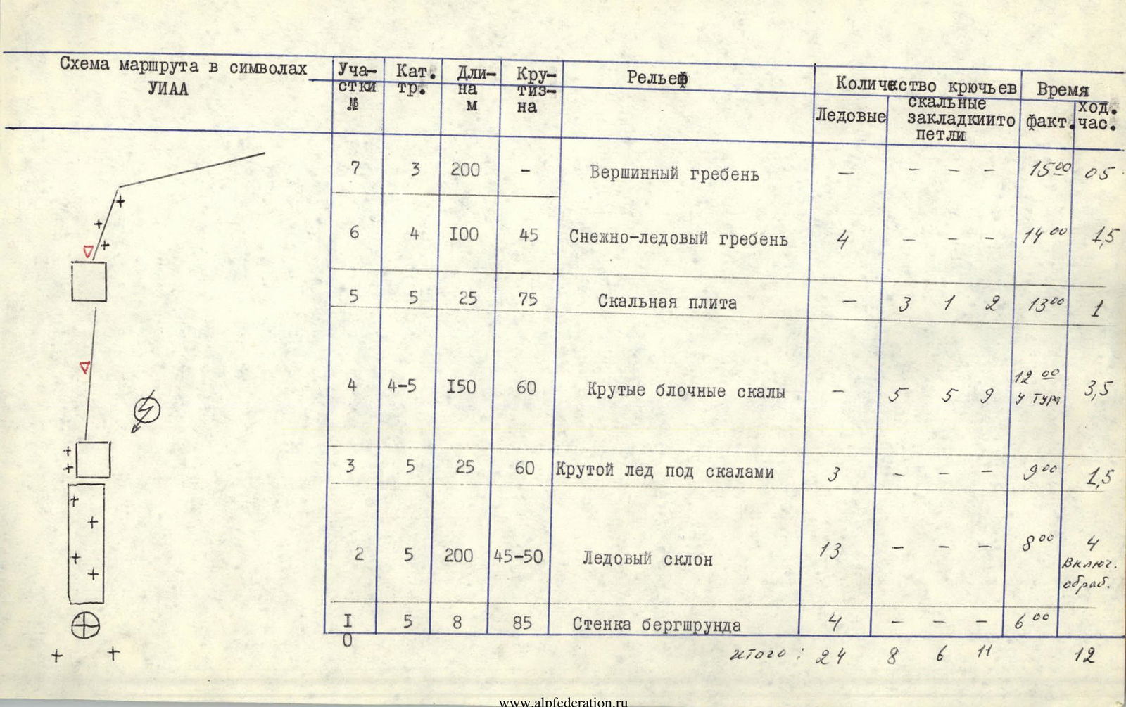
| Route Diagram in Symbols | Section # | Cat. Diff. | Length, m | Steepness | Relief | Number of Pitons | Time | ||
|---|---|---|---|---|---|---|---|---|---|
| Ice | Rock, Chocks, Slings | Actual | Climbing Hours | ||||||
| R7 | 3 | 200 | - | Summit Ridge | - | - | 15:20 | 05 | |
| R6 | 4 | 100 | 45° | Snow-Ice Ridge | 4 | - | 14:00 | 1.5 | |
| R5 | 5 | 25 | 75° | Rock Slab | - | 3, 1, 2 | 13:00 | 1 | |
| R4 | 4–5 | 150 | 60° | Steep Blocky Rocks | - | 5, 5, 9 | 12:00 at cairn | 3.5 | |
| R3 | 5 | 25 | 60° | Steep Ice under Rocks | 3 | - | 9:00 | 1.5 | |
| R2 | 5 | 200 | 45–50° | Ice Slope | 13 | - | 8:00 | 4 | |
| R0–R1 | 5 | 8 | 85° | Bergschrund Wall | 4 | - | 6:00 | ||
| Total: | 24 | 8, 6, 11 | 12 |
Route Description
To peak Zapadny Albattros (4740 m) via the N face, approximately 5A cat. diff. The North face of the Albattros massif in its upper part is a system of not very prominent rock buttresses separated by ice couloirs. The lower part of the face is purely ice. The buttress followed by the route leads slightly left of the summit of Zapadny Albattros onto the main crest of the massif and has a characteristic snow-ice ridge at the top. All buttresses to the right of this one are prone to rockfall.
To reach the route from the standard bivouac on the left-bank moraine of the Brigantina Glacier under peak Krogzor, follow:
- along the edge of the glacier towards the Solntse Pass,
- then cross the upper cirque of the glacier.
The start of the route (bergschrund) is reached by a steep snow slope (100 m, 35°).
The route begins with crossing the bergschrund (R0–R1, ice wall 8 m, 85°, 5). Then, climb the ice slope (R1–R2, 200 m, 45–50°, 5). Under the rocks, the ice becomes steeper (up to 50°). The base of the buttress, which is a rock wall (~20 m, 80°), is bypassed on the left via ice (R2–R3, 25 m, 60°, 5). Bypassing to the right is prone to rockfall! Via the first convenient ledge - exit onto the rocks. Then, follow the crest of the buttress (R3–R4, 150 m, 60°, 4–5). The last section of rocks is a smooth slab (R4–R5, 25 m, 75°, 5), which is climbed on the left. Then, follow the upper snow-ice ridge (R5–R6, 100 m, 45°, 4) to the main crest and along it (R6–R7, 200 m, 3) to the summit.
Descent is made to the Epur Pass and then to the Dzhigit Glacier. Two control cairns are left on the route:
- 1st - in the middle part of the rock buttress under characteristic "feathers";
- 2nd - at the end of the buttress under the snow-ice ridge.
Bivouacking on the route is convenient only near the 2nd control cairn.
Equipment recommendations: have 12-tooth crampons and an ice axe.