Yunost 4300 25 to the Summit ridge
P. Magomedova + 2
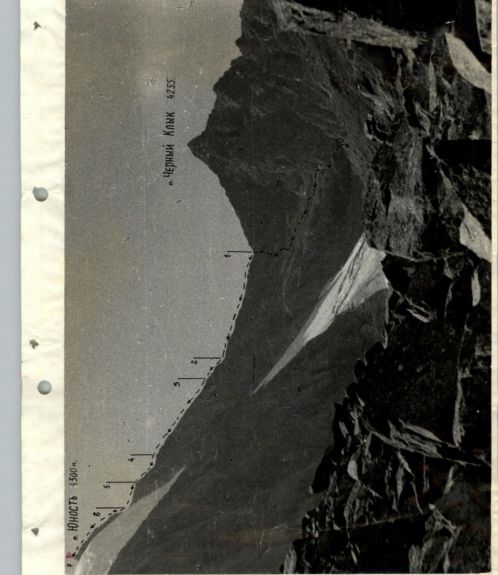
"Black Fang" 4255

Map of the axial part of the Terskey-Alatau ridge — upper reaches of the Djety-Oguz river.
Brief description of the approach to the route
Peak "Yunost" 4300 m (the height of the peak is given based on the topographic survey on a scale of 1:100,000, ed. 1962, is located in the northern spur of the Terskey-Ada-Too watershed ridge in the upper reaches of the left component of the Djety-Oguz river - the Baitor river, in the left part of the Baitor gorge (see map)).
From Przewalsk by bus to the Djety-Oguz resort. Further along the Djety-Oguz gorge along the road to the Telety gorge 12 km.
Then on foot along the Djety-Oguz gorge to the fork of the Baitor gorge:
- Ford to the left bank of the Djety-Oguz,
- Then cross over a log to the left bank of its tributary - Baitor.
On the left bank of the Djety-Oguz river, you can cross right at the Telety camp.
Along the Baitor gorge to the fork, then along the left bank of the Baitor river rise to the Baitor camp.
Movement everywhere along the horse trail. From Telety to Baitor camp about 4-5 hours with full backpacks. The camp has clean water, all camps are a good grassy ground.
From the camp 2-2.5 hours walk along the grassy slopes and along the moraine under the route. From the camp, the route is not visible.
Thus, the approaches to the route take:
- 2 hours by car
- 6-7.5 hours on foot, i.e. one full working day.
Table of main characteristics of the ascent route
Appendix No. 2

| Date | Section designation | Average steepness in degrees | Length in m. | Relief characteristics | Difficulty category | Condition | Weather conditions | Rock | Ice | Pitons | Exit to the route |
|---|---|---|---|---|---|---|---|---|---|---|---|
| August 10, 1978 | R0–R1 | 45° | 400 | Rocky shelves | 2 | Destruction rocks | Sunny, warm | 2 | – | – | Exit from camp 4:00 |
| R1–R2 | 20°–35° | 300 | Large stones | 1 | Covered with snow | " | Simultaneous movement | Exit to the route 7:00 | |||
| R2–R3 | 70° | 60 | Ridge | 3 | Vertical slabs | " | 2/4 | – | – | ||
| R3–R4 | 45° | 200 | " | 3 | Destruction rocks, shelves | " | 0/5 | – | – | ||
| R4–R5 | 40°–50° | 80 | " | 3 | Clean slabs | " | 2/3 | – | – | ||
| R5–R6 | 40° | 80 | " | 3 | Clean rocks | " | 2 | – | – | ||
| R6–R7 | 50°–60° | 160 | " | 3 | " | " | 3/6 | – | – | Exit to the summit 16:00. Descent along the ascent path | |
| Total | 1280 m | ||||||||||
| Average steepness 45° | |||||||||||
| Length of sections 3-4 difficulty category 580 m. |
Notation: numerator - rock hooks, denominator - ledges.


