Ascent Passport
Appendix No. 1 24 ASCENT PASSPORT
- Ascent class — technical
- Ascent area — Central Tian-Shan, Terskey Ala-Too ridge
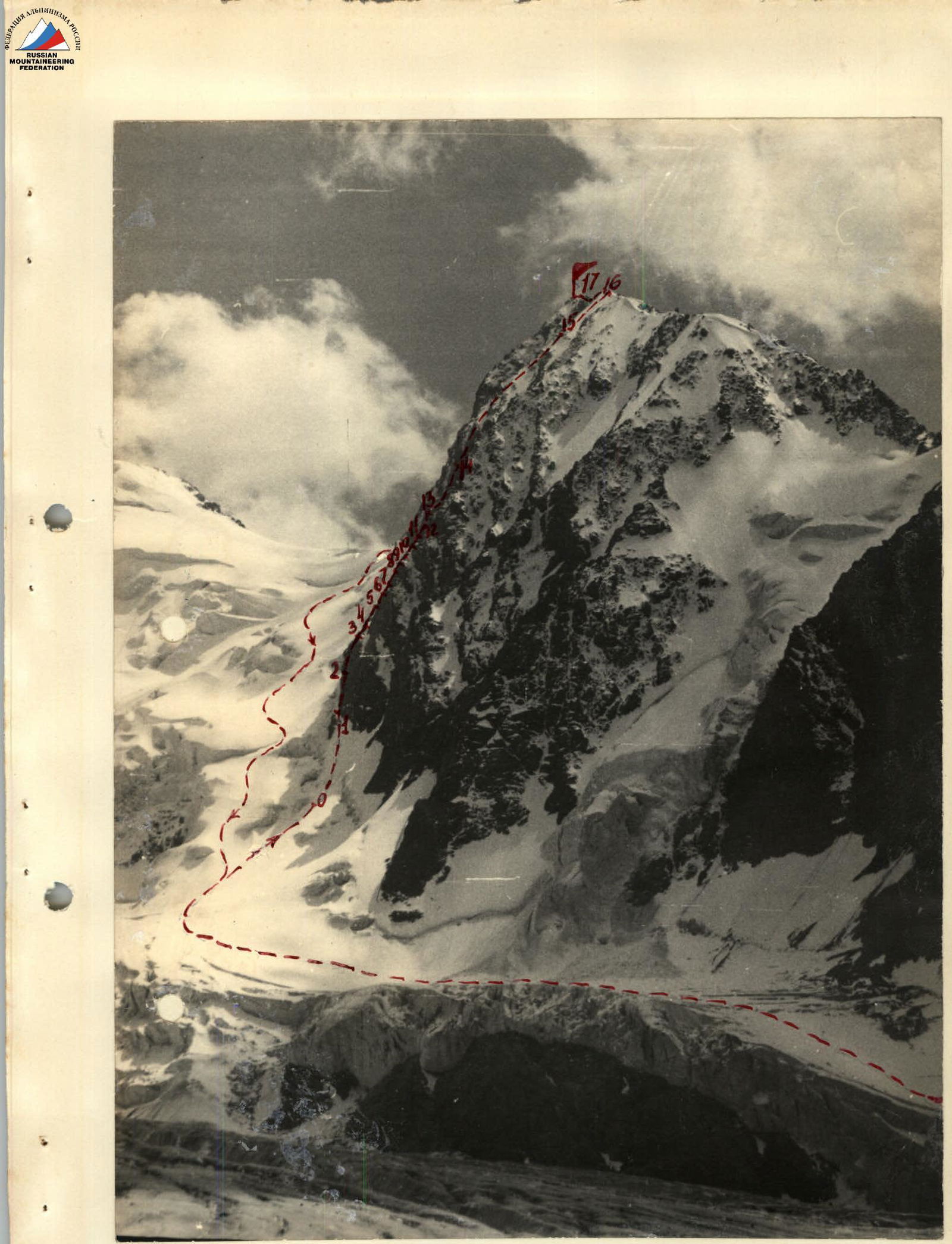
- Peak — p. 60-letiya Velikoy Oktyabr'skoy Sotsialisticheskoy revolyutsii, height 4906 m, ascent route — via the eastern counterfort (3rd ascent)
- Expected difficulty category — 5B
- Route characteristics: height difference — 900 m average steepness — 75° length of sections with 5–6 difficulty category — 530 m
- Pitons driven: for belaying — 92, including rock — 76, ice — 16, bolt — 0 for creating artificial holds, including rock — 5, ice — 0, bolt — 0
- Number of climbing hours — 14:30
- Number of bivouacs and their characteristics — without bivouacs
- Full name of the leader, participants, and their qualification:
- Orlov Sergey Tikhonovich, 1st sports category
- Onin Alexander Alexandrovich, 1st sports category
- Team coach: Biryukov V.N., Candidate Master of Sports, senior instructor
- Date of departure on the route — August 4, 1978 date of return — August 1, 1978
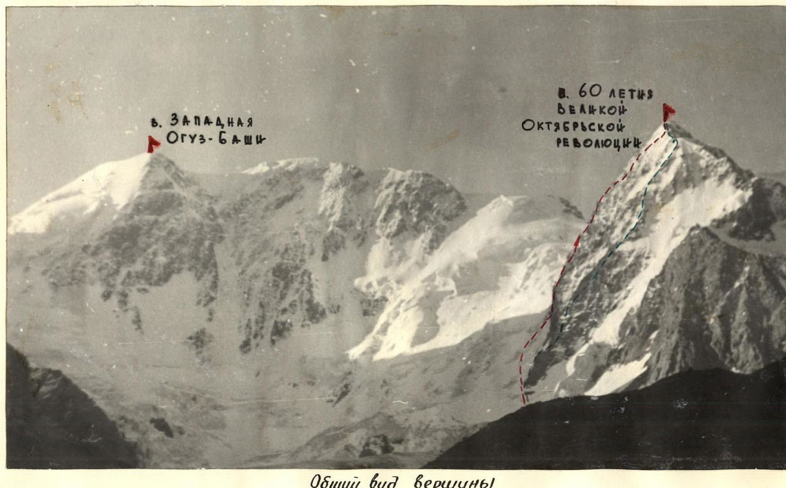
General view of the peak
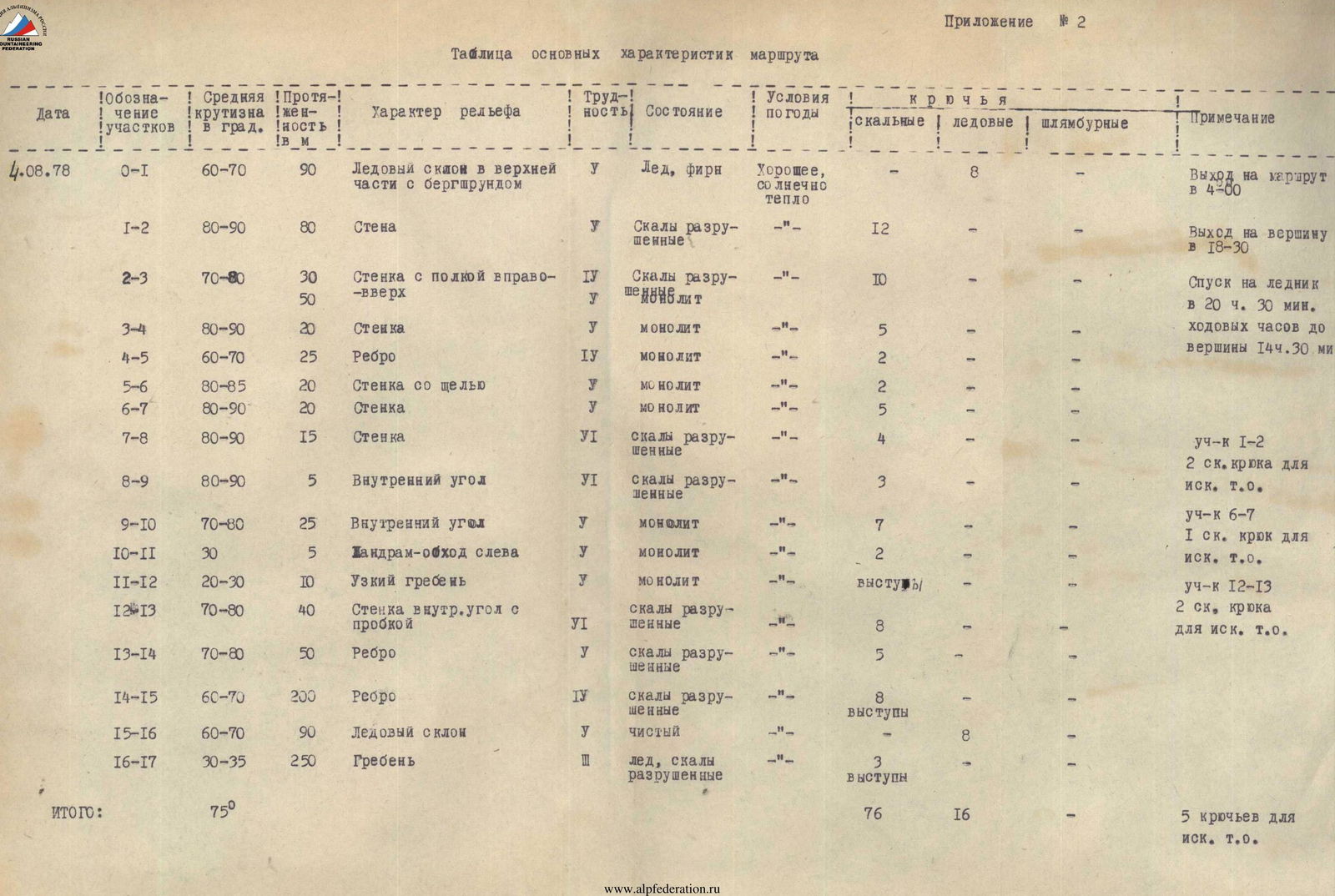
Appendix No. 2
Table of main route characteristics
| Date | Designation of sections | Average steepness in degrees | Length in m | Terrain characteristics | Difficulty | Condition | Weather conditions | Rock pitons | Ice pitons | Bolt pitons | Notes |
|---|---|---|---|---|---|---|---|---|---|---|---|
| 4.08.78 | R0–R1 | 60–70 | 90 | Ice slope with a bergschrund in the upper part | Y | Ice, firn | Good, sunny, warm | 8 | Departure on the route at 4:00 | ||
| R1–R2 | 80–90 | 80 | Wall | Y | Broken rocks | 12 | Reach the summit at 18:30 | ||||
| R2–R3 | 70–80 | 30 | Wall with a shelf to the right-up | IY | Broken rocks | 10 | Descent to the glacier at 20:30. Climbing hours to the summit 14:30. | ||||
| 50 | Y | Monolith | |||||||||
| R3–R4 | 80–90 | 20 | Wall | Y | Monolith | 5 | |||||
| R4–R5 | 60–70 | 25 | Ridge | IY | Monolith | 2 | |||||
| R5–R6 | 80–85 | 20 | Wall with a crevice | F | Monolith | 2 | |||||
| R6–R7 | 80–90 | 20 | Wall | Y | Monolith | 5 | Section R1–R2: 2 rock pitons for artificial holds | ||||
| R7–R8 | 80–90 | 15 | Wall | VI | Broken rocks | 4 | Section R6–R7: 1 rock piton for artificial holds | ||||
| R8–R9 | 80–90 | 5 | Inner corner | VI | Broken rocks | 3 | Section R12–R13: 2 rock pitons for artificial holds | ||||
| R9–R10 | 70–80 | 25 | Inner corner | Y | Monolith | 7 | |||||
| R10–R11 | 30 | 5 | Gendarme bypass to the left | Y | Monolith | 2 | |||||
| R11–R12 | 20–30 | 10 | Narrow ridge | Y | Monolith | ledges | |||||
| R12–R13 | 70–80 | 40 | Wall with an inner corner and a plug | VI | Broken rocks | 8 | |||||
| R13–R14 | 70–80 | 50 | Ridge | Y | Broken rocks | 5 | |||||
| R14–R15 | 60–70 | 200 | Ridge | IY | Broken rocks | 8 ledges | |||||
| R15–R16 | 60–70 | 90 | Ice slope | Y | Clean | 8 | |||||
| R16–R17 | 30–35 | 250 | Ridge | Ice, broken rocks | 3 ledges | ||||||
| Total: | 75° | 76 | 16 | 5 pitons for artificial holds |
Brief description of the table
3.08.1978. At 18:00 the group departed from the Baitor camp and approached the observers' tent on the medial moraine of the Baitor glacier within 1 hour's walk from the route. 4.08.1978. At 2:30 the pair of climbers departed from the bivouac site and approached the route at 3:30. Movement on the route began at 4:00. Having passed a relatively gentle (60–65°) left slope and overcome the bergschrund, the pair approached the wall via steep ice. From the moment the wall was lit by the sun, stones began to fall in large quantities along the adjacent couloirs to the right of the wall; however, the pair was in relative safety under the wall. The walls are predominantly very steep (up to 82–90°), heavily broken rocks (less often monolithic). Passing the wall with a move to the left on a vaguely expressed ridge, exit to a narrow oblique shelf and, adhering to it, move to the right-up. There are few holds, and pitons were used in some places to hang ladders. Two stone-hazardous gullies were crossed, through which water was flowing. Traverse to the right, up a monolithic steep wall, pass the rock ridge leading up from it, and after 40 m of difficult rocks, move to the right-up to the main ridge. The ridge is very steep, heavily broken, representing a system of parallel narrow ridges and an inner corner between them. Exit via a wall of "live" stones and then via the inner corner to the second bivouac site of the first ascenders. Above the site is a steep inner corner (30 m) of very complex climbing; exit to a narrow rock ridge "knife". The immediately rising gendarme after the "knife" is bypassed to the left via a wall — through narrow rock cracks (complex climbing). Further behind the gendarme is a narrow rock ridge "knife" and an approach via a steep wall (40 m) with an inner corner, almost a chimney, in which a large stone — a "plug" — is weakly wedged. The rocks are very steep, broken, and stone-hazardous; the "plug" in the chimney is also unreliable. Very complex and cautious climbing. After passing this wall, there is a section of rock ridge (50 m) with very unreliable mobile blocks, also requiring very cautious and complex climbing. Further, the ridge (200 m) becomes somewhat gentler (70°), but is heavily broken, and its passage requires extreme caution.
Further — an ice slope (90 m) from 65° in the lower part to 70° in the upper part — exit to the ridge. On the ridge, sections of rock and ice alternate — passed quickly. At 18:30 the pair reached the summit. Descent from the summit to the saddle towards the Baitor pass and from the saddle to the glacier under the bergschrund took 2 hours (20:30). Following the route marked by observers through the icefall, descended to the tent in 1 hour (21:30). Within 2 hours, the group of climbers and observers returned to the Baitor camp (23:30)
Route profile