Ascent Passport
I. Ascent class - technical 2. Ascent area - Central Tien Shan, Terskey-Alatau ridge. 3. Peak - p. 60-letiya Velikoy Oktyabrskoy Sotsialisticheskoy Revolyutsii, height 4906 m, ascent route - via the eastern counterfort. 4. Proposed difficulty category - 5B. 5. Route characteristics: height difference - 900 m average steepness - 75° length of sections with 5-6 cat. diff. - 532 m. 6. Pitons driven: for belay - 94, including rock - 76 ice - 18 bolt - 0 for creating artificial holds, including rock - 8 ice - 0 bolt - 0 7. Number of climbing hours - 13 8. Number of nights and their characteristics: - no overnight stays. 9. Surname, first name, patronymic of the leader, participants and their qualification:
- Streletsov E.A., CMS
- Bochkov D.S., 1st sports category
- Team coach - Biryukov V.N., CMS, senior instructor.
- Date of departure on the route - August 1, 1978, date of return - August 3, 1978.
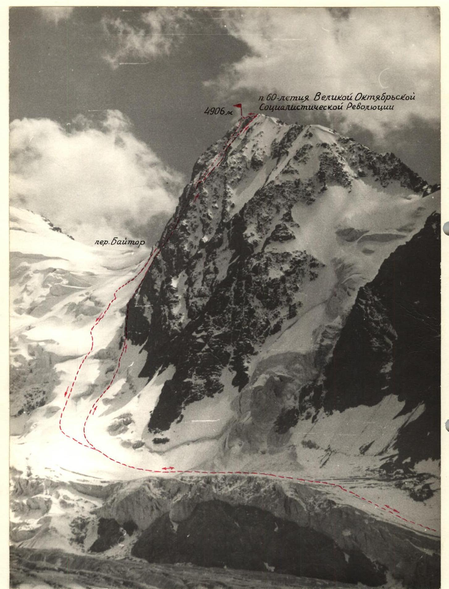
The group's route (following the path of the first ascenders - the group of the Kyrgyz RS DSO "Burevestnik" in 1977).
Brief explanation of the table
- August 7, 1978. At 16:00, the group left the Baytor campsite accompanied by two observers and set up a tent on the median moraine of the Baytor glacier, a 1-hour walk from the route.
- August 7, 1978. At 4:20, the climbing duo left the tent and approached the route by 5:30. Half an hour later, i.e., at 6:00, they began moving along the route. After passing a relatively gentle (60-65°) left slope and overcoming the bergschrund, the duo approached the wall via steep ice. As the wall was exposed to sunlight, rocks began to fall in large quantities through the adjacent couloirs to the right and left of the wall, but the duo was relatively safe under the wall. The walls are predominantly very steep (up to 85-90°), heavily deteriorated rocks (less often monolithic). The passage of the wall is done by veering left, onto a vaguely defined rib, exiting onto a narrow oblique shelf, and, adhering to it, moving up to the right. There are few holds, and pitons were used in some places to hang ladders. They crossed the mouths of two rockfall-prone gullies through which water was flowing. They traverse up to the right, along a monolithic steep wall, pass a rock rib leading up from it, and after 35 m of difficult rock climbing, they exit onto the main rib.
The rib is very steep, heavily deteriorated, representing a system of parallel narrow ribs and an internal angle between them. Exit is made via a wall of "live" rocks and then along the internal angle - to the second campsite of the first ascenders.
Above the platform - a steep internal angle (30 m) of very complex climbing; exit onto a narrow rock ridge-"knife". The immediately following gendarme is bypassed on the left via a wall - through narrow cracks and rock ledges (complex climbing). Further beyond the gendarme - a narrow rock ridge-"knife" and an approach to a steep wall (35 m) with an internal angle, almost a chimney, in which a large rock "plug" is weakly wedged. The rocks are very steep, deteriorated, and rockfall-prone; the "plug" in the chimney is also unreliable. Very complex and cautious climbing. After passing this wall - a section of rock rib (50 m) with very unreliable mobile blocks, also requiring very cautious and complex climbing.
Further, the rib (200 m) becomes somewhat gentler (70°), but is heavily deteriorated, and its passage requires extreme caution.
Next - an ice slope (80 m) from 65° in the lower part to 70° in the upper, with carving out a cornice on the ridge - exit onto the ridge. On the ridge - alternating sections of rock and ice - are passed quickly. At 19:00, the duo reached the summit. The descent from the summit to the saddle towards the Baytor pass and from the saddle to the glacier under the bergschrund took 2 hours (by 21:00). Following the path marked by observers through the icefall, they descended to the tent in 1 hour (22:00). August 3, 1978. The group of climbers and observers returned to the Baytor campsite by 12:00.
In case of a possible overnight stay, the climbing duo took with them foam pads, percale cloaks, down jackets, a "Febus" stove, and fur socks. The duo of observers had a "Nedra" radio station for communication with the Telety base camp and the Baytor campsite.
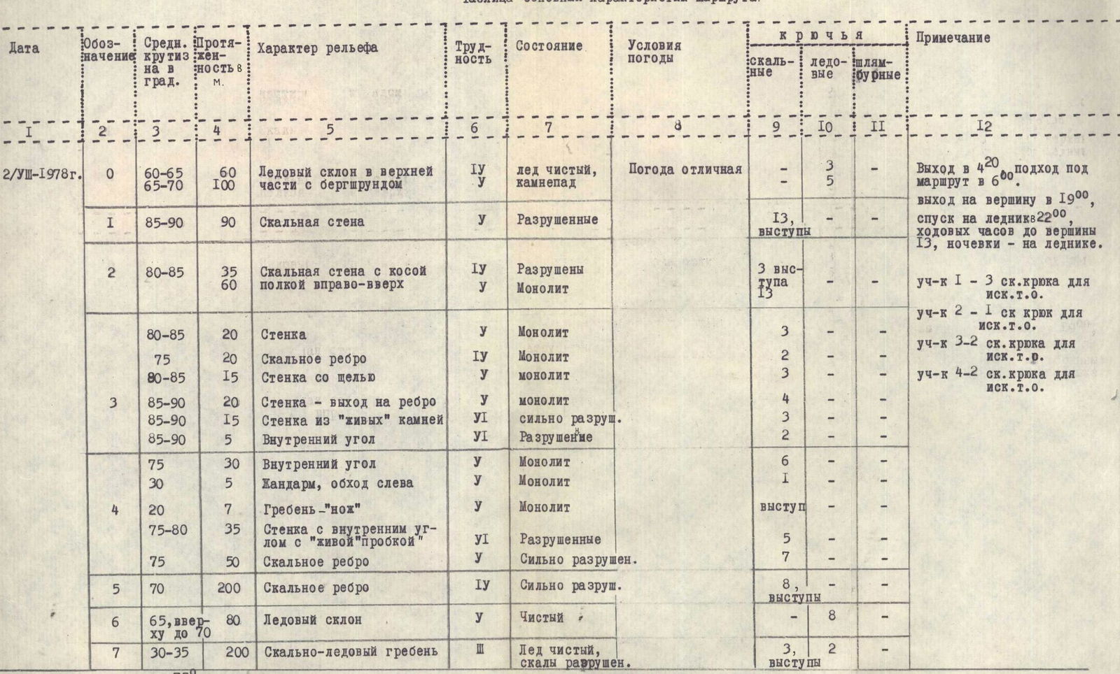
Table of main route characteristics.
| Date | Designation | Average steepness in degrees | Length in m | Nature of terrain | Difficulty | Condition | Weather conditions | Pitons: rock | Pitons: ice | Pitons: bolt | Notes |
|---|---|---|---|---|---|---|---|---|---|---|---|
| August 2, 1978 | 0 | 60–65 | 60 | Ice slope in the upper part with bergschrund | 1 | Ice clean, rockfall | Excellent weather | 3 | – | – | Departure at 4:20, approach to the route at 6:00. |
| 65–70 | 100 | 2 | 5 | Reached the summit at 19:00, descended to the glacier by 22:00, climbing hours to the summit 13, no overnight stays on the glacier. | |||||||
| 1 | 85–90 | 90 | Rock wall | 2 | Deteriorated | 13, ledges | – | – | |||
| 2 | 80–85 | 35 | Rock wall with an oblique shelf up to the right | 1 | Deteriorated | 3, ledges | Section 1 - 3 rock pitons for artificial holds | ||||
| 60 | 2 | Monolithic | 13 | Section 2 - 1 rock piton for artificial holds | |||||||
| 80–85 | 20 | Wall | 2 | Monolithic | 3 | – | – | Section 3 - 2 rock pitons for artificial holds | |||
| 75 | 20 | Rock rib | 1 | Monolithic | 2 | – | – | ||||
| 80–85 | 15 | Wall with a slit | 2 | Monolithic | 3 | – | – | Section 4 - 2 rock pitons for artificial holds | |||
| 3 | 85–90 | 20 | Wall - exit onto rib | 2 | Monolithic | 4 | – | – | |||
| 85–90 | 15 | Wall of "live" rocks | 6 | Heavily deteriorated | 3 | – | – | ||||
| 85–90 | 5 | Internal angle | 6 | Deterioration | 2 | – | – | ||||
| 75 | 30 | Internal angle | 2 | Monolithic | 6 | – | – | ||||
| 30 | 5 | Gendarme, bypass on the left | 2 | Monolithic | 1 | – | – | ||||
| 4 | 20 | 7 | Ridge-"knife" | 2 | Monolithic | ledge | |||||
| 75–80 | 35 | Wall with an internal angle with a "live 'plug'" | 6 | Deteriorated | 5 | – | – | ||||
| 75 | 50 | Rock rib | 6 | Heavily deteriorated | 7 | – | – | ||||
| 5 | 70 | 200 | Rock rib | 1 | Heavily deteriorated | 8, ledges | – | – | |||
| 6 | 65, up to 70 at the top | 80 | Ice slope | 2 | Clean | 8 | – | – | |||
| 7 | 30–35 | 200 | Rock-ice ridge | 3 | Ice clean, rocks deteriorated | 3, ledges | 2 | – | |||
| Average | |||||||||||
| Total 94 pitons driven for belay, including 76 rock, 18 ice. 8 rock pitons driven for artificial holds. |