REPORT
on the ascent to the peak "60 лет Октябрьской революции" via the north-eastern edge (second ascent) 4Б cat. diff., accomplished by the group of Kyrgyz RS DSO "Spartak" Frunze, 1978.
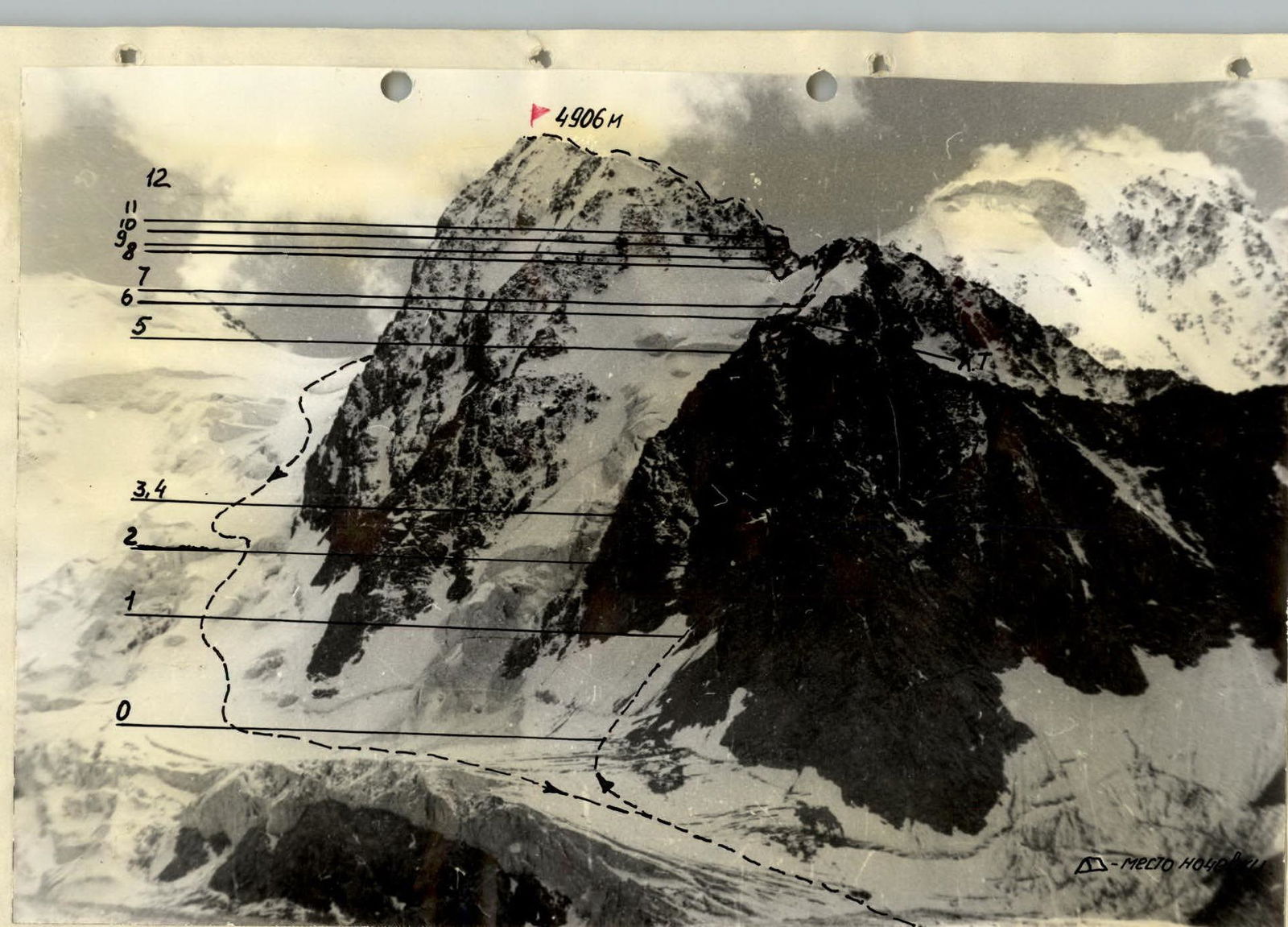
General view of the route
BRIEF EXPLANATION OF THE TABLE
Approach from the Baitor camp to the route. The route follows a not clearly defined broad counterfort. Passable ice slope 45°, 80 m. Exit into a narrow couloir, which leads to a ledge in front of a monolithic rock wall. We move left along a snow-ice slope with step cutting, piton belay. Further, two ropes of difficult rock directly upwards, rocks are heavily destroyed. Control cairn on the ledge. From the ledge upwards along difficult rocks, three ropes. Further 20 m of easy rocks, exit onto the ridge. At 20:00, we stop for the night on a rock ledge. Control cairn. Departure from the bivouac at 8:00. Along an ice slope with rock outcrops, we exit onto the main ridge. Along easy rocks, we reach a saddle. Further, one rope of snow-ice slope, one rope of rock ascent, and the ridge continues with easy rocks, steepness up to 40°. Along it, we exit onto the summit. Descent towards the Baitor pass, further down the icefall onto the Baitor glacier and down to the camp.
Appendix 2
Characteristics of the route sections, part 1
| Date | Section designation | Average steepness, ° | Length, m | Terrain character | Difficulty | Condition | Weather conditions | Belay, rock pitons | Belay, ice pitons | Belay, bolt pitons | Passage, rocks, m | Passage, ice, m | Passage, bolts, m | Length (day/section), m | Time of departure/arrival, climbing hours, bivouac conditions |
|---|---|---|---|---|---|---|---|---|---|---|---|---|---|---|---|
| July 26, 1977 | O–1 | 60° | 80 | ice | IУ | Clean | excellent | 9 | Departure 14:00, Arrival – 20:00, Climbing – 8:00, Bivouac lying | ||||||
| 1–2 | 65° | 80 | ice | IУ | Clean | 10 | |||||||||
| 2–3 | 85° | 250 | slope | УА | destroyed | 26 | – | ||||||||
| average for the day | 78° | 410 | 26 | 20 | – | 2 | |||||||||
| July 27, 1977 | 3–4 | 40° | 20 | ice ledge | IУ | Clean | satisfactory | 1 | Departure – 7:00, Arrival – 20:00, Climbing – 12:00, Bivouac sitting, Convenient ledge | ||||||
| 4–5 | 90° | 30 | wall | VI | destroyed | 2 | |||||||||
| 5–6 | 90° | 40 | internal angle | УБ | destroyed | 12 | |||||||||
| 6–7 | 80° | 40 | wall | УБ | destroyed | 18 | |||||||||
| 7–8 | 85° | 40 | wall | УБ | destroyed | 15 | |||||||||
| 8–9 | 95° | 5 | overhanging rock | VI | monolith | 17 | |||||||||
| 9–10 | 85° | 120 | wall | УА | destroyed | 3 | |||||||||
| 10–11 | 80° | 215 | wall | УА | destroyed | 19 | |||||||||
| average for the day | 79° | 510 | 30 | 1 | 2 | 7 | |||||||||
| July 28 | 11–12 | 70° | 130 | rocks covered with ice | УБ | destroyed | poor snow | 18 | Started working at 7:00, Arrival at 15:00, Climbing – 8:00, Bivouac lying | ||||||
| 12–13 | 60° | 160 | ice | IУ | Clean | ||||||||||
| average for the day | 65° | 290 | 18 | 17 | |||||||||||
| Total on the wall: | 76° | 1210 m | 159 | 39 | 9 | ||||||||||
| average steepness | |||||||||||||||
| July 29, 1977 | 13–14 | 30° | 250 | ice ridge | IУ | Clean | wind, snow | 1 | departure at 7:30, arrival – 19:00, climbing – 10:00, bivouac lying under p. Karakolsky | ||||||
| 14–15 | 40° | 85 | ice slope | III | Clean | 10 | |||||||||
| 15–16 | 85° | 20 | wall | УБ | rocks covered with ice | 4 | |||||||||
| 16–17 | 20° | 160 | snow-ice ridge | УА | cornices | 3 | |||||||||
| 17–18 | 85° | 8 | wall | УБ | monolith | 6 | |||||||||
| First summit | |||||||||||||||
| 18–19 | 0° | 120 | snow-ice ridge | УА | cornices | 1 | |||||||||
| 19–21 | -20° | 75 | snow-ice ridge | УА | cornices | 6 |
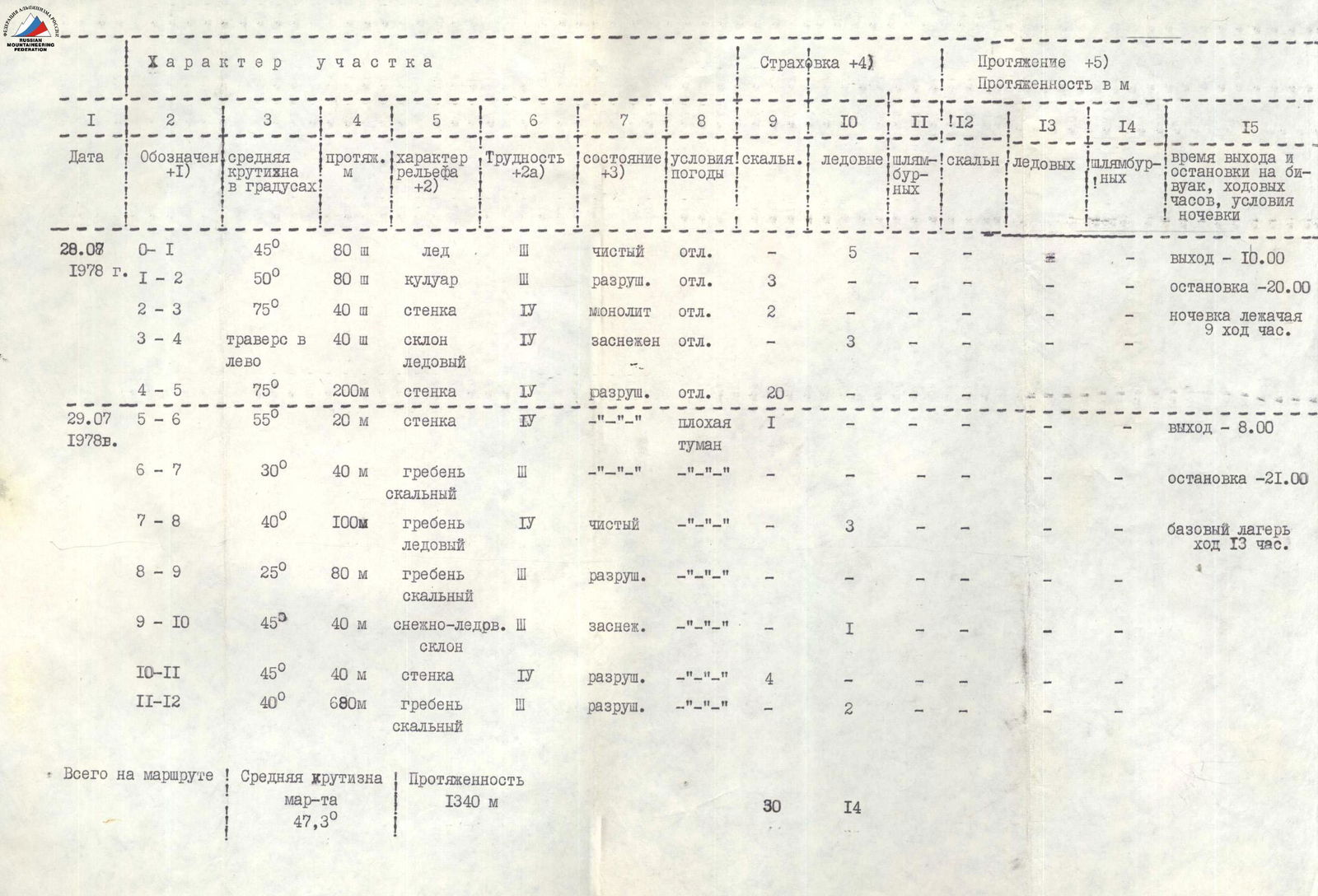
Characteristics of the route sections, part 2
| Date | Section designation | Average steepness, ° | Length, m | Terrain character | Difficulty | Condition | Weather conditions | Belay, rock pitons | Belay, ice pitons | Belay, bolt pitons | Passage, rocks, m | Passage, ice, m | Passage, bolts, m | Length (day/section), m | Time of departure/arrival, climbing hours, bivouac conditions |
|---|---|---|---|---|---|---|---|---|---|---|---|---|---|---|---|
| July 28, 1978 | O–1 | 45° | 80 | ice | III | clean | excellent | 5 | departure – 10:00, arrival – 20:00, bivouac lying 9 hours | ||||||
| 1–2 | 50° | 80 | couloir | III | destroyed | excellent | 3 | ||||||||
| 2–3 | 75° | 40 | wall | IУ | monolith | excellent | 2 | ||||||||
| 3–4 | traverse left | 40 | ice slope | IУ | snow-covered | excellent | 3 | ||||||||
| 4–5 | 75° | 200 | wall | IУ | destroyed | excellent | 20 | ||||||||
| July 29, 1978 | 5–6 | 55° | 20 | wall | IУ | poor fog | 1 | departure – 8:00 | |||||||
| 6–7 | 30° | 40 | rock ridge | III | arrival – 21:00 | ||||||||||
| 7–8 | 40° | 100 | ice ridge | IУ | clean | 3 | |||||||||
| 8–9 | 25° | 80 | rock ridge | III | destroyed | ||||||||||
| 9–10 | 45° | 40 | snow-ice slope | III | snow-covered | 1 | |||||||||
| 10–11 | 45° | 40 | wall | IУ | destroyed | 4 | |||||||||
| 11–12 | 40° | 680 | rock ridge | III | destroyed | 2 | |||||||||
| Total on the route | Average steepness of the route 47.3° | 1340 m | 30 | 14 | base camp, 13 hours of climbing |
Protocol of the ascent review
July 30, 1978
review of the ascent to the summit "60 лет Октябрьской революции" via the north-eastern edge, on a route of 4Б cat. diff. in the composition:
Trempol'tsev G.I. Keleberdenko T.N. July 28–29, 1978, second ascent.
Present: Trempol'tsev G.I., Keleberdenko T.N., Viryukov V.N. — supervisor, Duiko V.I. — head of the rescue team.
Trempol'tsev G.I. We left the base camp at 6:00, approached the route at 9:30. We started the route at 10:00.
- We traversed the ice slope on crampons.
- We entered a couloir, where we moved with piton belay, and drove in 3 rock pitons.
- Further, left along a snow-ice slope on crampons with step cutting, belay via ice pitons, exit onto rocks.
- Above, 5 ropes of rock, in the middle of this section, a control cairn.
- Exit onto a small ridge.
Bivouac at 20:00. We departed the bivouac at 8:00, the weather deteriorated.
- Along rocks and an ice slope onto the main ridge.
- Along the ridge to the summit.
We reached the summit at 15:00. Descent towards the Baitor pass and further down the icefall onto the Baitor glacier.
The ascent was enjoyable, and I am satisfied with my partner.
Keleberdenko T.N. — I would like to add that the rocks are quite destroyed, and therefore it is necessary to be extremely cautious during the ascent and to climb in a group of 2–3 people. The route corresponds to 4Б cat. diff.
Viryukov V.N. — supervisor. The ascent was carried out in accordance with the rules of mountaineering in the USSR. The ascent is confirmed.