Ascent Passport
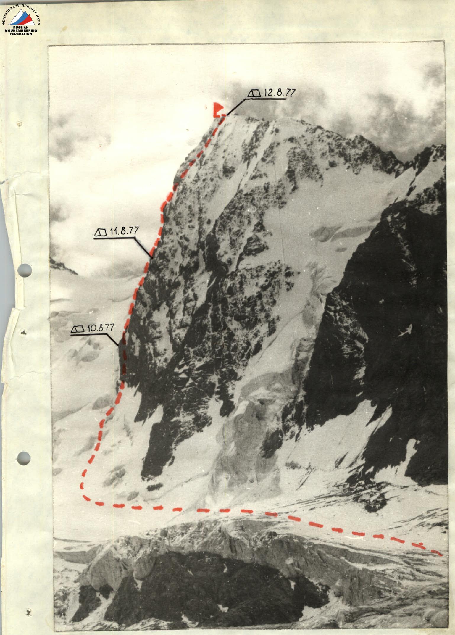
I. Ascent class — technical 2. Ascent area — Central Tien Shan, Terskey Ala-Too ridge, Jety-Oguz gorge. 3. Peak, its height, ascent route: 60 let Velikoy Oktyabr'skoy Sotsialisticheskoy Revolyutsii (5006) via W buttress. 4. Expected difficulty category — 5B 5. Ascent characteristics: height difference — 900 m, average steepness — 75°, length of complex section 5–6 cat. diff. 620 m 6. Pitons hammered: rock 143, ice 25, bolt 0, of which for creating artificial holds — 15 7. Number of climbing hours — 44 8. Number of overnight stays and their characteristics: 1. Sitting bivouac 2. Semi-reclining 3. Lying bivouac 9. Surname, name, patronymic of the leader, participants and their qualification: 1. Popov F.E. — leader, CMS — instructor 2. Kuzmenko B.S. — participant, CMS 3. Kudashkin Yu.V. — participant, CMS — instructor 4. Biryukov V.N. — participant, CMS — senior instructor 5. Sabirov M.S. — participant, CMS — instructor 6. Alibegashvili L.M. — participant, CMS — instructor 10. Team coach Popov F.E. 11. Date of departure on the route August 10, 1977 and return August 13, 1977
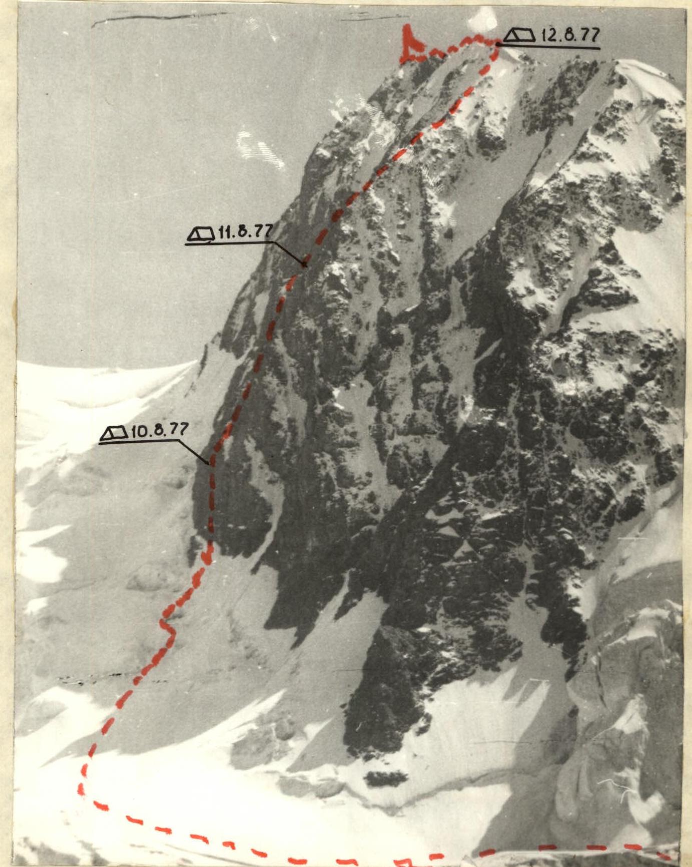
ROUTE TAKEN BY THE GROUP
ROUTE PROFILE
II. Approach to the route
From the "Jety-Oguz" sanatorium, we drive by car to the Telety gorge, which takes 2 hours. The road ends here. Then follows a 3-hour transition along the Jety-Oguz gorge to the fork (the gorge splits into the Jety-Oguz gorge and the Bay-Tor gorge). After an overnight stay, we ascend along the Baytor gorge to the location of the base camp, which was situated 17 km below the glacier, immediately behind the valley plateau. The last transition takes 2 hours. From the base camp, we reach the Western Oguz-Bashi glacier and along it, a 3-hour transition on the right side of the glacier (along the route) to the peak 60th anniversary of the Great October Socialist Revolution.
Character of the section Appendix 2
| Date | Designation | Average steepness (°) | Length (m) | Terrain characteristics | Difficulty | Condition | Weather conditions | Hammered: rock | Hammered: ice | Hammered: bolt | For passage: rock | For passage: ice | For passage: bolt | Time, bivouac conditions |
|---|---|---|---|---|---|---|---|---|---|---|---|---|---|---|
| August 10, 1977 | R0–R1 | 60° | 50 m | ice | 1 | snow-covered | excellent | 3 | Departure at 9:00, stop at 19:00, climbing hours 9 h 30 min, sitting bivouac | |||||
| R1–R2 | 65° | 110 m | ice | 1 | clean | 9 | 10 | |||||||
| R2–R3 | 80° | 80 m | wall | 3 | destroyed | 20 | ||||||||
| R3–R4 | 85° | 20 m | wall | 1 | destroyed | 5 | ||||||||
| August 11, 1977 | R4–R5 | 80° | 80 m | wall | 1 | monolithic | good | 20 | Departure at 7:30, stop at 21:00, climbing hours 14 h, semi-reclining | |||||
| R5–R6 | 85° | 20 m | chimney | 3 | iced | 6 | 3 | |||||||
| R6–R7 | 75° | 40 m | slope | 1 | destroyed | 2 | 10 | |||||||
| R7–R8 | 85° | 80 m | wall | 1 | destroyed | 1 | 23 | |||||||
| August 12, 1977 | R8–R9 | 75° | 40 m | slope | 1 | destroyed | satisfactory | 8 | Departure at 7:00, stop at 20:00, climbing hours 12 h, good lying bivouac | |||||
| R9–R10 | 80° | 20 m | knife-edge | 1 | monolithic | 4 | 3 | |||||||
| R10–R11 | 95° | 5 m | cornice | 3 | monolithic | 2 | ||||||||
| R11–R12 | 85° | 15 m | wall | 1 | monolithic | 1 | ||||||||
| R12–R13 | 75° | 60 m | wall | 1 | destroyed | 4 | 16 | |||||||
| R13–R14 | 90° | 10 m | wall | 1 | monolithic | 1 | 8 | |||||||
| R14–R15 | 75° | 120 m | slope | 1 | destroyed | 1 | 10 | |||||||
| R15–R16 | 65° | 80 m | ice | 1 | clean | 12 | ||||||||
| August 13, 1977 | R16–R17 | 30° | 200 m | rocky-ice ridge | poor | 6 | Departure at 11:00, stop at 20:00, climbing hours 9 h | |||||||
| Total on the route | 75° | 1020 m | 143 | 25 | 0 |