Passport
I CLASS 2-technical. Central Tian-Shan, Terskey Ala-Too ridge, Jety-Oguz gorge. Oguz-Bashi Peak (5170) via North-East wall. 4A cat. diff.
Height difference: 1600 m, wall section: 900 m. Length: 2700 m (including descent to the glacier). Length of sections with 5-6 diff.: 700 m. Average slope of the route: 55°, with 6 diff.: 75°.
Pitons used:
- rock: 25
- ice: 32
- chocks: 16.5
Team's travel time: 48 hours, days: 4.
Nights:
- 1st — sitting on a ledge
- 2nd — all four on an inclined ice ledge, sitting
- 3rd — comfortable in a tent (on the ridge, in a hollow)
Leader: Yermolaev Yuri Alexandrovich, CMS. Members:
- Gaydamak Vladimir Alekseevich, CMS
- Kozhin Evgeny Ivanovich, CMS
- Katz Matvey Semenovich, CMS
Coach: Yermolaev Yuri Alexandrovich, CMS.
Route start: July 22, 1990. Summit: July 24, 1990. Return: July 25, 1990.
Organization: Committee for Physical Culture and Sports of Omsk Regional Executive Committee. 644010, Omsk, Lenina, 41.
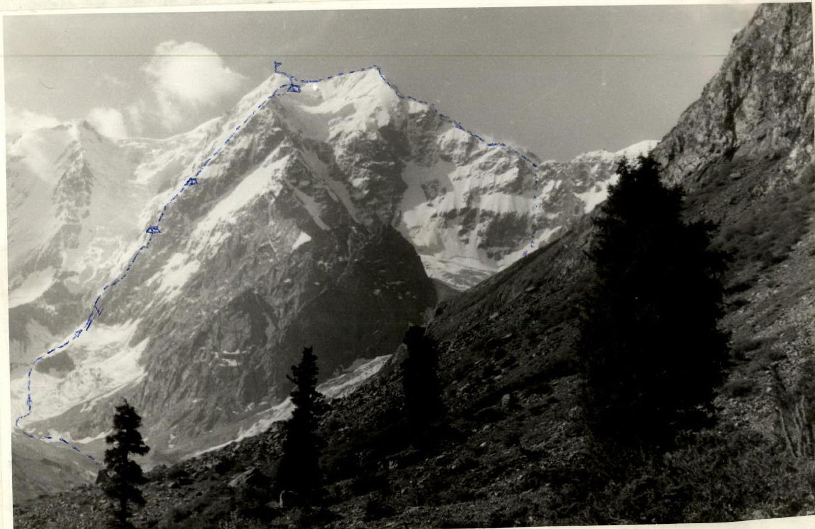
General view. "Zenit" camera. View from the moraine.
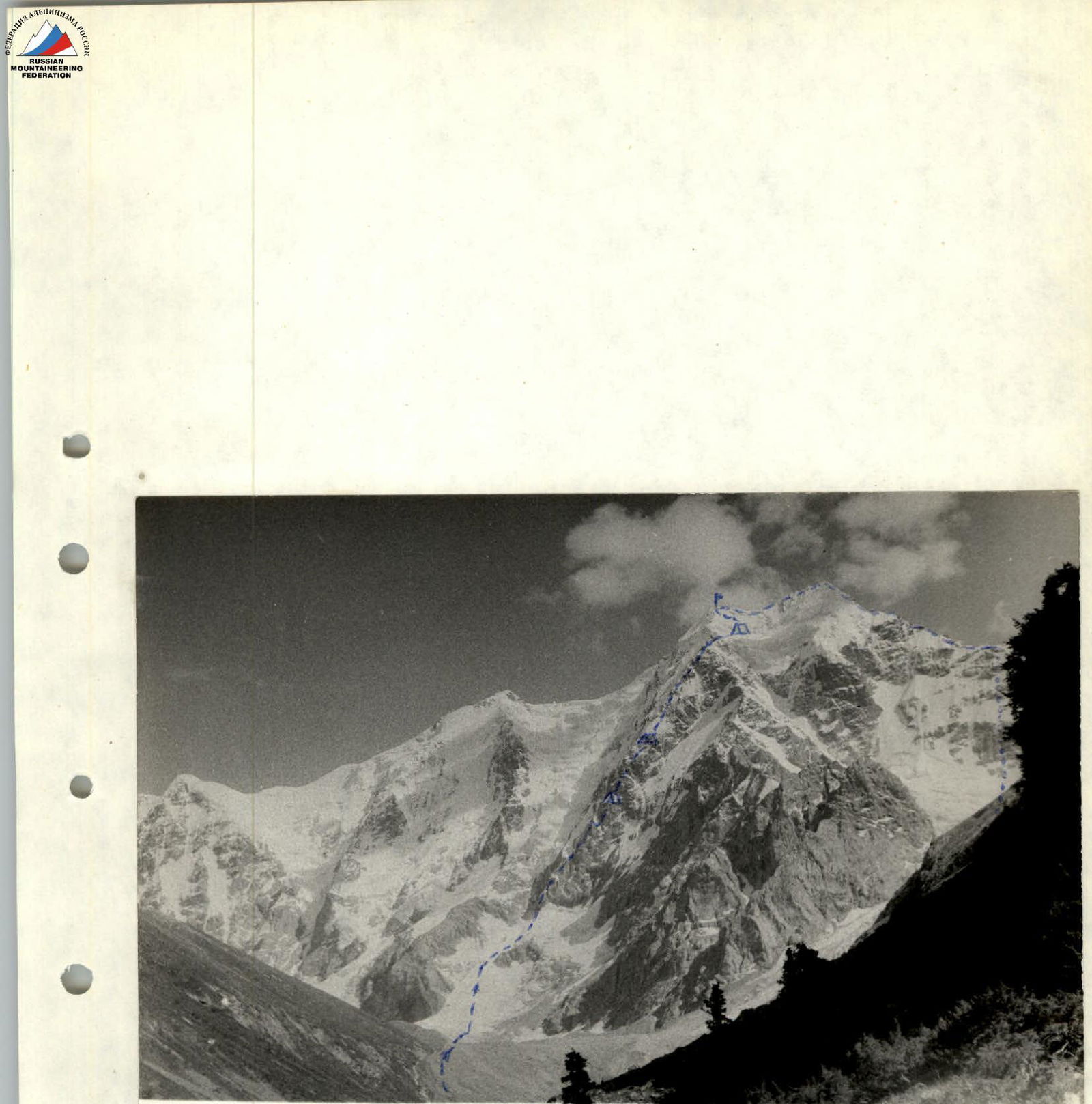
General view.
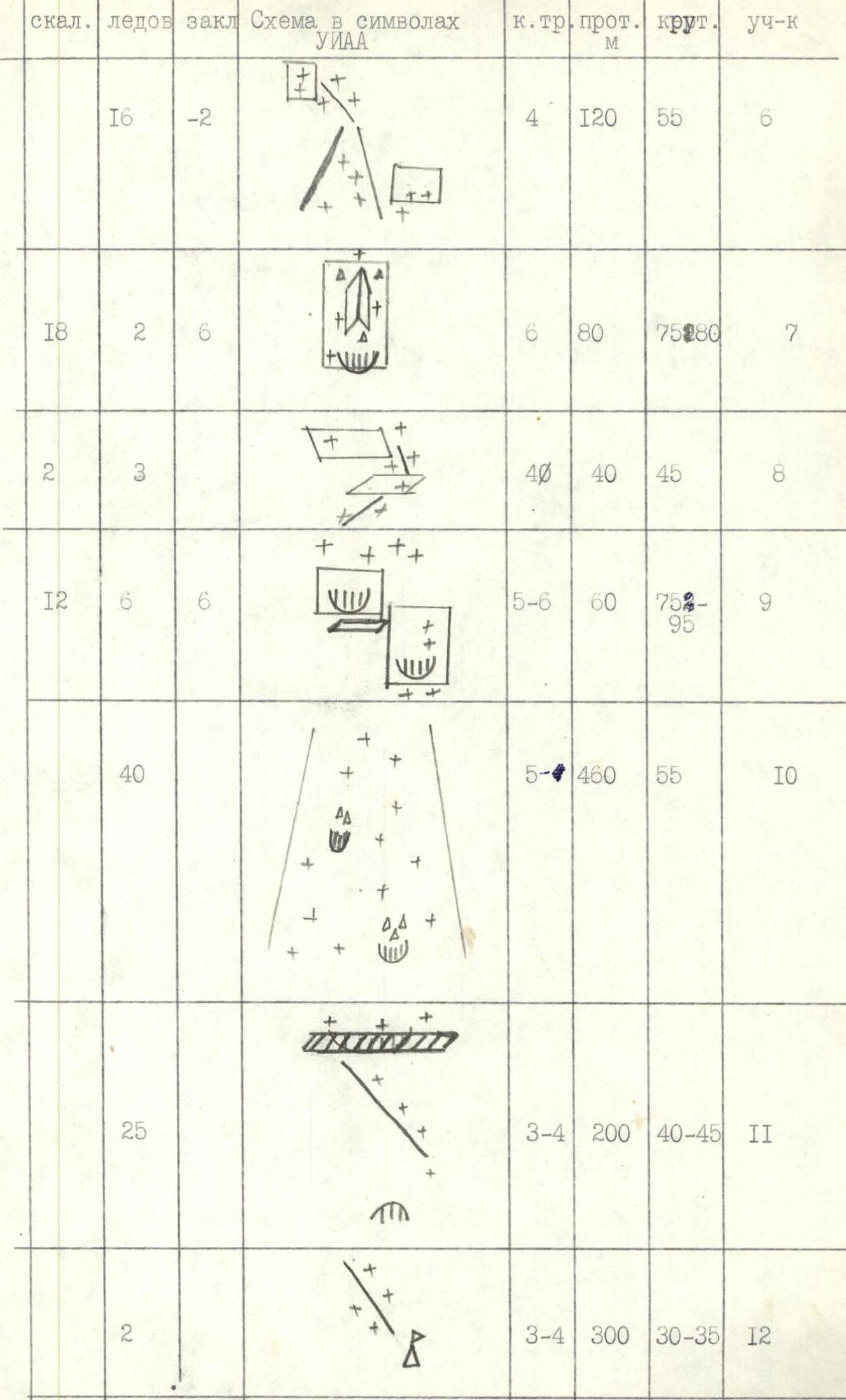
Technical description of the route, UIAA symbol scheme (M I: 2000)
| Rock | Ice | Chocks | UIAA Route Symbol | Diff. cat. | Length, m | Slope, ° | Section |
|---|---|---|---|---|---|---|---|
| 4 | 3 | 40 | 40 | R1 | |||
| 5 | 3 | 2 | 4–3 | 200 | 35–45 | R2 | |
| 12 | 6 | 4 | 6–5 | 100 | 60–75 | R3 | |
| 3 | 24 | 4 | 6–5 | 120 | 60–80 | R4 | |
| 4 | 6 | 2 | 4 | 80 | 55 | R5 | |
| 16 | -2 | 4 | 120 | 55 | R6 | ||
| 18 | 2 | 6 | 6 | 80 | 75–80 | R7 | |
| 2 | 3 | 40 | 40 | 45 | R8 | ||
| 12 | 6 | 6 | 5–6 | 60 | 75–95 | R9 | |
| 40 | 5 | 460 | 55 | R10 | |||
| 25 | 3–4 | 200 | 40–45 | R11 | |||
| 2 | 3–4 | 300 | 30–35 | R12 |
Route scheme.
The entire route was traversed with the organization of the first belay and passage by the other participants with backpacks, using jammers with upper protection. The first climber was completely unloaded, except for technical equipment. The entire route, due to the icy rocks, was traversed in crampons.
Route description by sections
R1 — steep ice-snow slope. At the top — bergschrund. Movement on crampons — on the front teeth. Belay through ice screws, using shock tools (ice axe, ice hammer).
R2 — internal angle turning into a couloir. Rocks are icy. Used: all forms of rock pitons, chocks, ice-axes.
R3 — inclined shelves, then wall. Difficult climbing. Used: schweller pitons, hook-nogs. Rocks with ice accretion.
R4 — slabs and oblique shelves with ice. Difficult climbing on front teeth, on hook-nogs. Used: ice screws, chocks, rock pitons. Walls with niches and cornices.
R5 — inclined slabs alternating with walls. Walls with cornices, much ice accretion. Used ice-axes, rock and ice pitons. Overnight stay on an inclined rock shelf, safe.
R6 — fallen snow made movement on crampons on ice difficult. Belay with ice axes and ice screws.
R7 — wall with internal angle and cornices, rockfall hazard. Climbing is very difficult, piton belay.
R8 — inclined shelves with snowy ridges, ice under the snow. Good place for overnight stay. Belay with rock and ice pitons.
R9 — ice slope turning into a rock wall with slabs of negative inclination. Very difficult climbing using hook-nogs and piton belay.
R10 — steep ice-snow slope. Movement on front teeth. Option: to avoid being under the cornices, go right between rock outcrops. Belay with ice screws. Overnight stay extremely uncomfortable, on a narrow ice ledge, sitting.
R11 — snow-ice slope with rock islands. Exit through a cornice onto the ridge (Myslovsky's 5B route). Cornice is traversed from right to left. Belay with ice pitons.
R12 — snowy ridge with individual ice outcrops, traversed simultaneously. Overnight stay under an ice rise before the main ridge, in a hollow, very comfortable, without wind.
R13 — pre-summit rise is snowy. Summit is dome-shaped. Cairn is below to the right of the summit, among rocks. Descent is difficult along the north-eastern ridge — sharp, high cornices on both sides. Belay is alternating and simultaneous with ice screws and ice axes.